donsutherland1
-
Posts
24,194 -
Joined
Content Type
Profiles
Blogs
Forums
American Weather
Media Demo
Store
Gallery
Everything posted by donsutherland1
-
Strong ENSO Climatology: A Pair of Hideous Maps: It should be noted that skill deteriorates during Week 2. It remains more likely than not that the maps are showing a pause in Winter 2023-24, not its demise, even as the CFSv2 is showing a February 2016-type outcome with almost coast-to-coast warmth. A lot more evidence would be needed to adopt the more extreme idea that Winter 2023-24 is all but finished.


-
I suspect that if it snows near the end of the month, and that's not certain, it would be a light snowfall. A lot of the forecast pattern would need to change for there to be a real opportunity for a moderate or greater snowfall. At present, the operational 12z ECMWF is an outlier relative to its own ensembles.
-
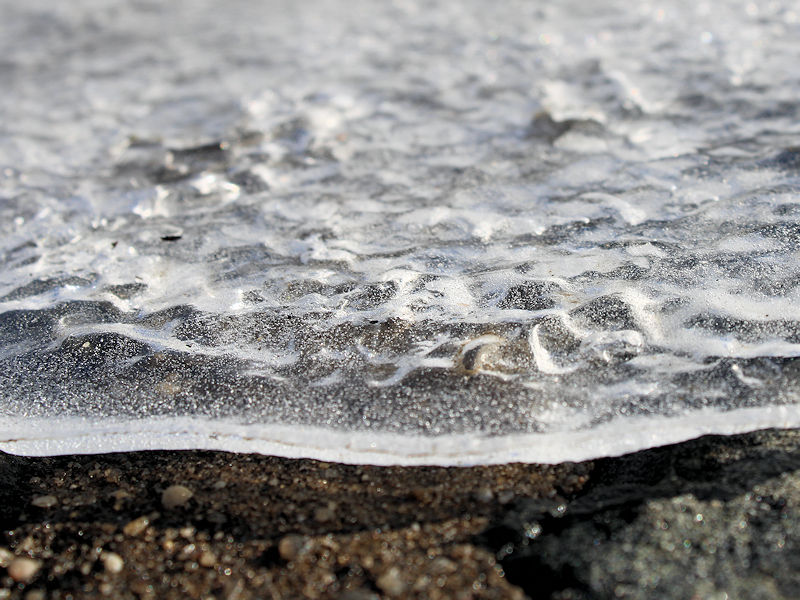
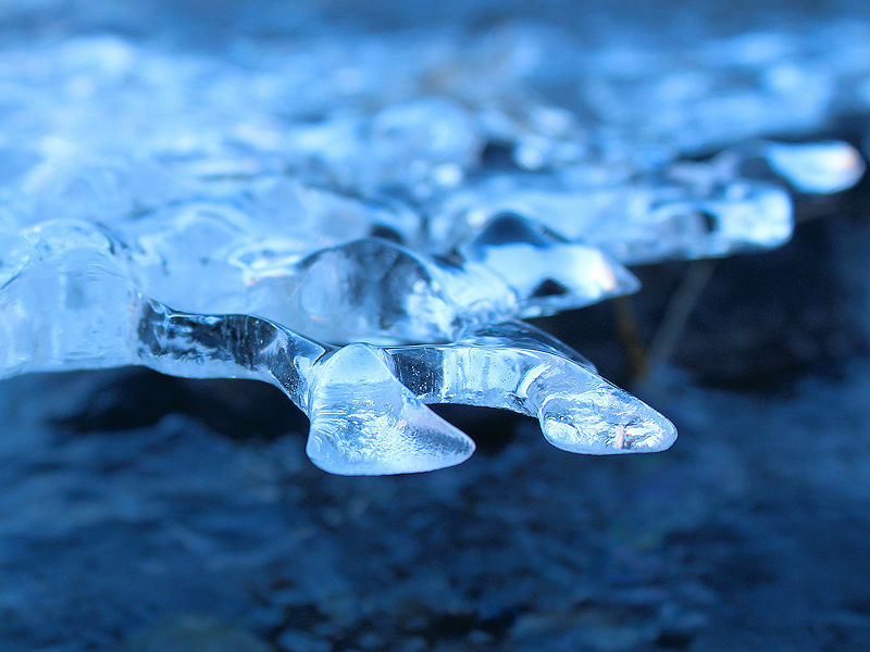
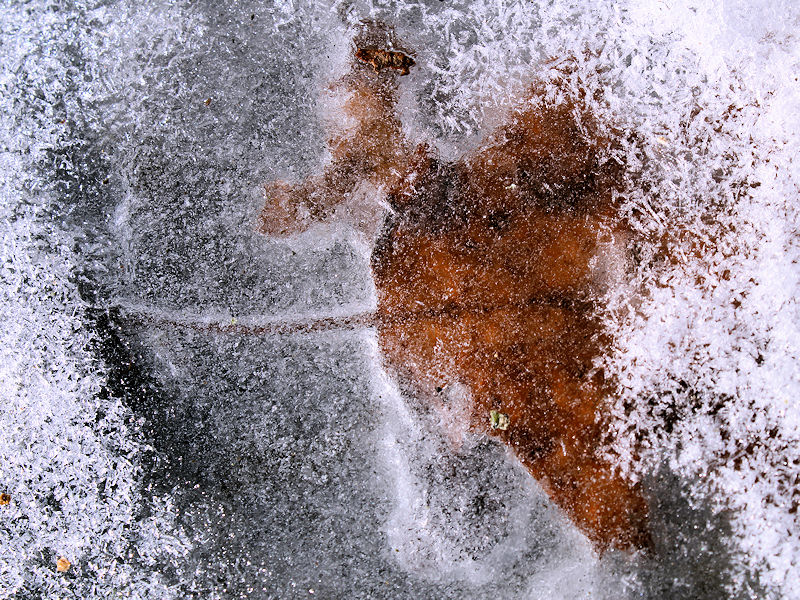
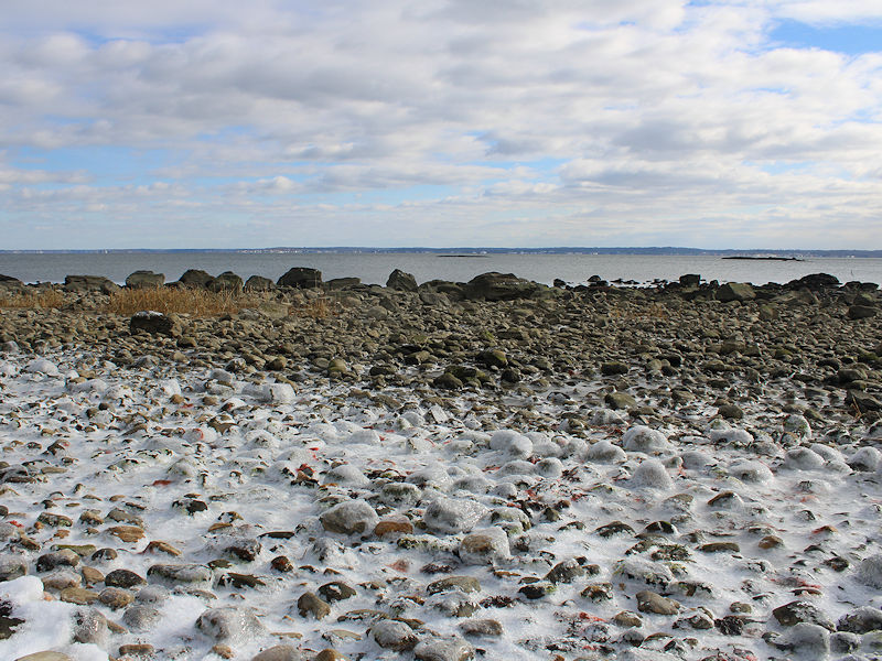
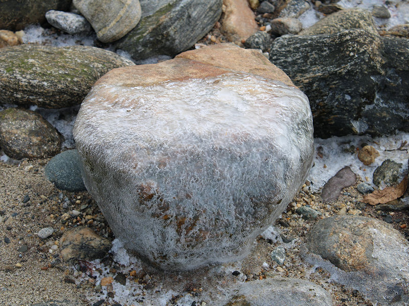
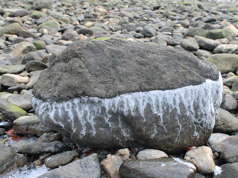
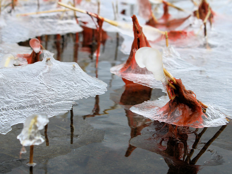
Ice photos from today. The freeze will be ending tomorrow.

-
-11 is the record for ACY and -16 is the record for Trenton.
-
I actually ran across the storm while doing some research at the New York Public Library. Ludlum's books are historical weather treasures.
-
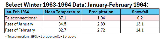
Monthly snowfall totals for 1963-64: November: Trace December: 11.3" January: 13.3" February 14.1" March: 6.1" April: Trace Total: 44.8"
-
Here's a summary of data for January and February 1964 in New York City:
-
Even as prospects for snowfall have diminished for at least the next week, Wednesday could see some ice issues, generally from the Hudson Valley north and westward.
-
-2 at JFK.
-
Yes, but that winter’s patterns were generally very good for snowfall. The 12 days of a horrible pattern didn’t have much impact. The lack of snow during those 12 days during a snowy winter illustrates just what a bad pattern it is.
-
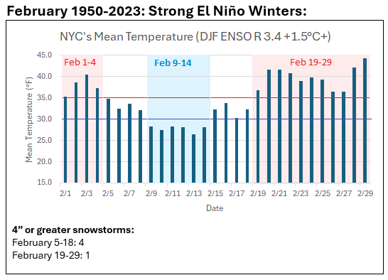
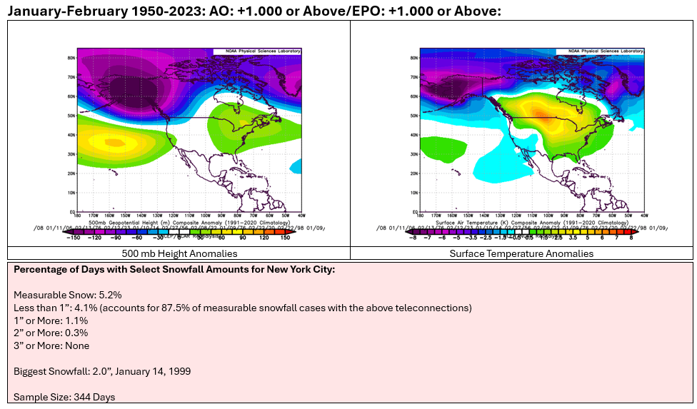
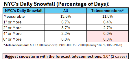
Such patterns are not common. For the January-February 1950-2023 period, there were 4,606 days with 344 (7.5%) meeting the criteria (AO: +1.000 or above /EPO +1.000 or above). There were three winters where January-February saw 10 or more such days. 1963-64: 14 days; Total snowfall during those days: 0.2" 1988-89: 22 days; Total snowfall during those days: None 2019-20: 12 days; Total snowfall during those days: 0.2"
-
Week ahead numbers: Mild with perhaps a strong shot of warmth and wet.
-
I agree. That’s why I termed it a pause.
-
It’s a much weaker signal than for December and January. So far, the Washington, DC area has had some snowfall. Hopefully, after the upcoming pause, there will be some bigger storms.
-
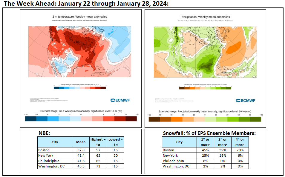
A genuine "kiss of death" for snowfall pattern for January and February would be the combination of an AO of +1.000 or above and EPO of +1.000 or above. Such a pattern yields much below climatological frequency of measurable snowfall in New York City. The largest snowfall among the 344 dates that met those criteria was just 2.0". So far, the guidance does not show more than a few such days. Therefore, even as the forecast pattern for the closing 7-10 days of January is not a good one, it could be worse.
-
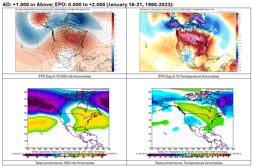
Following another night in the teens in New York City and some single-digits outside of New York City and Newark, tomorrow will be fair and cold. Readings will approach or reach freezing in parts of the region. Afterward, the development of an EPO+/AO+ pattern will lead to a noticeable warming trend that could send temperatures well into the 40s across the region and even into the 50s in parts of the region. This warm period will assure that January will wind up as a warmer than normal month and Winter 2023-24 will become yet another warmer than normal winter in the New York City and Philadelphia areas. The expected monthly warm anomaly has increased in recent days as the development of this pattern has grown increasingly likely. The generally mild conditions could continue into the first week of February with only brief interruptions. The ENSO Region 1+2 anomaly was +0.9°C and the Region 3.4 anomaly was +1.9°C for the week centered around January 10. For the past six weeks, the ENSO Region 1+2 anomaly has averaged +1.18°C and the ENSO Region 3.4 anomaly has averaged +1.95°C. A basinwide El Niño event is ongoing. The ongoing El Niño event has recently peaked. The SOI was +15.13 today. The preliminary Arctic Oscillation (AO) was +0.568 today. That is the first positive reading this month. Should the AO remain positive for the remainder of this month as is indicated on the guidance, it will have been negative on 58% of days during December and January. That is consistent with historic experience. Strong blocking in the final week of November, as occurred this year, has often been followed by frequent blocking in December and January. On January 18 the MJO was in Phase 5 at an amplitude of 2.993 (RMM). The January 17-adjusted amplitude was 2.729 (RMM). Based on sensitivity analysis applied to the latest guidance, there is an implied 93% probability that New York City will have a warmer than normal January (1991-2020 normal). January will likely finish with a mean temperature near 36.2° (2.5° above normal).
-
Lighter events with the EPO+/AO+ combination being forecast. The biggest was 3”. 8”+ shown on the 6z GFS wasn’t realistic. It’s worth tracking things while having an idea of what’s plausible and what’s unlikely.
-
With temperatures remaining below freezing, water is beginning to freeze over in the New York City suburbs. The cold will be shortlived.

-
I agree. The forecast pattern for the end of January is hostile. Solutions such as the 6z GFS for significant snowstorms should be discounted.
-
We've had measurable snow. The percentage of days with measurable snow with an AO+/NAO+ is lower than it is when the AO and NAO are negative. The chart I posted had specific ranges of teleconnections (AO: +1.000 or above; EPO: 0.000 to +2.000) as forecast on the EPS and GEFS. NYC has not seen a greater than 3" snowstorm during the second half of January with that pattern. It had measurable snowfall on almost 12% of such days (little lower than climatology).
-
Some snow is certainly plausible. The kind of snowfall shown on the 6z GFS (and retracted on the following 12z run) is not. Unfortunately, no measurable snowfall is also a possible outcome (above climatological probability). The PNA+ should blunt the magnitude of warmth, but overall, the remainder of the January should be warmer than normal. As for the AO-/NAO-, all of NYC's measurable snowfall has occurred with the AO- and almost all of its measurable snowfall has occurred with the NAO-. The PNA- limited opportunities for a big snowfall. The kind of AO+/EPO+ pattern that is forecast is not a snowy one, even when the PNA is positive.
-
Today, the Arctic Oscillation rose to positive levels for the first time this month. That is the first piece of what is forecast to become an AO+/EPO+ pattern. Such patterns consistent with the forecast (AO: +1.000 or above/EPO: 0.000 to +2.000) support below normal frequency of measurable snow events during the second half of January. Based on the guidance (temperature anomalies and forecast pattern), New York City will likely see little or no snowfall for the remainder of this month.
-
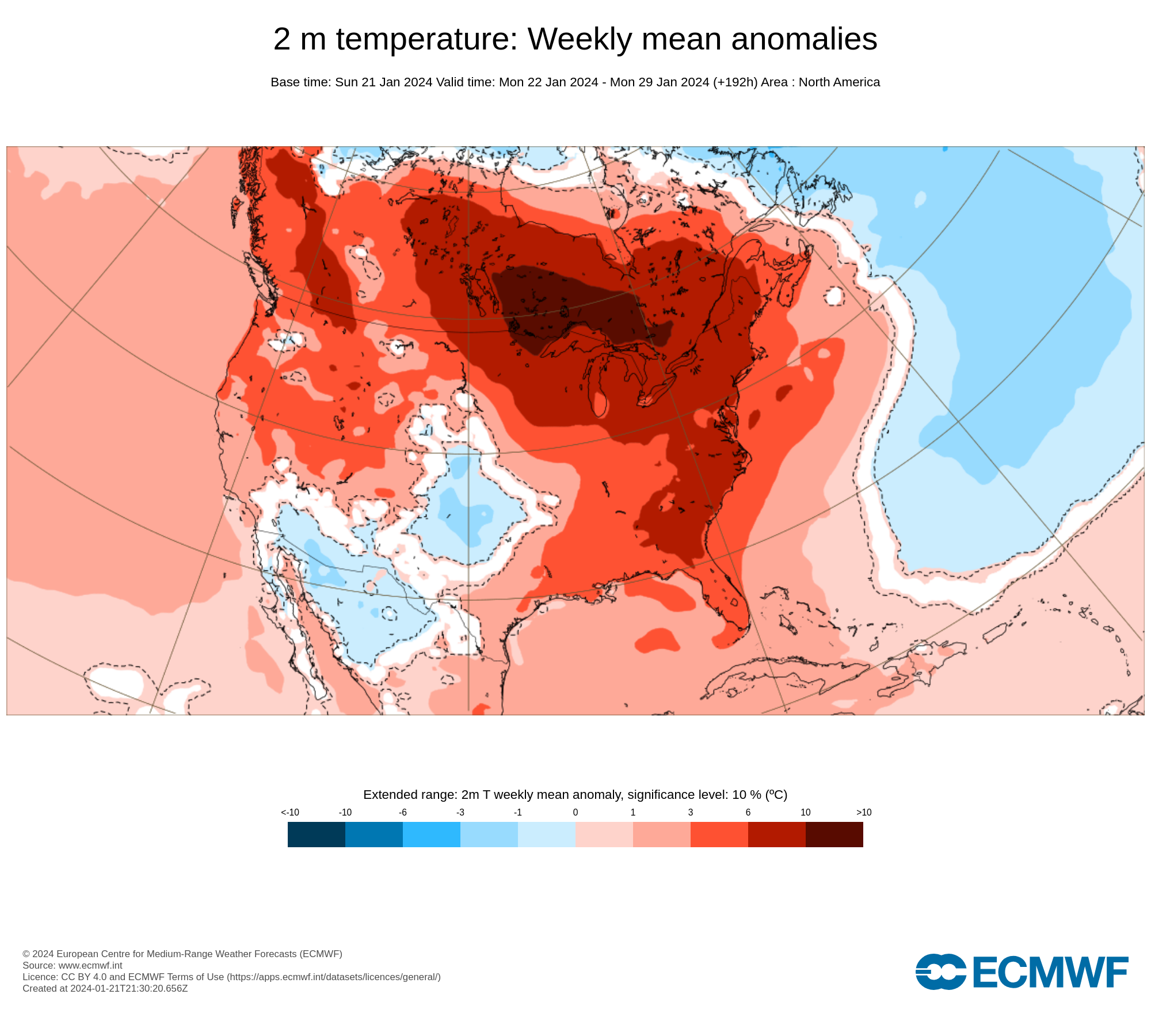
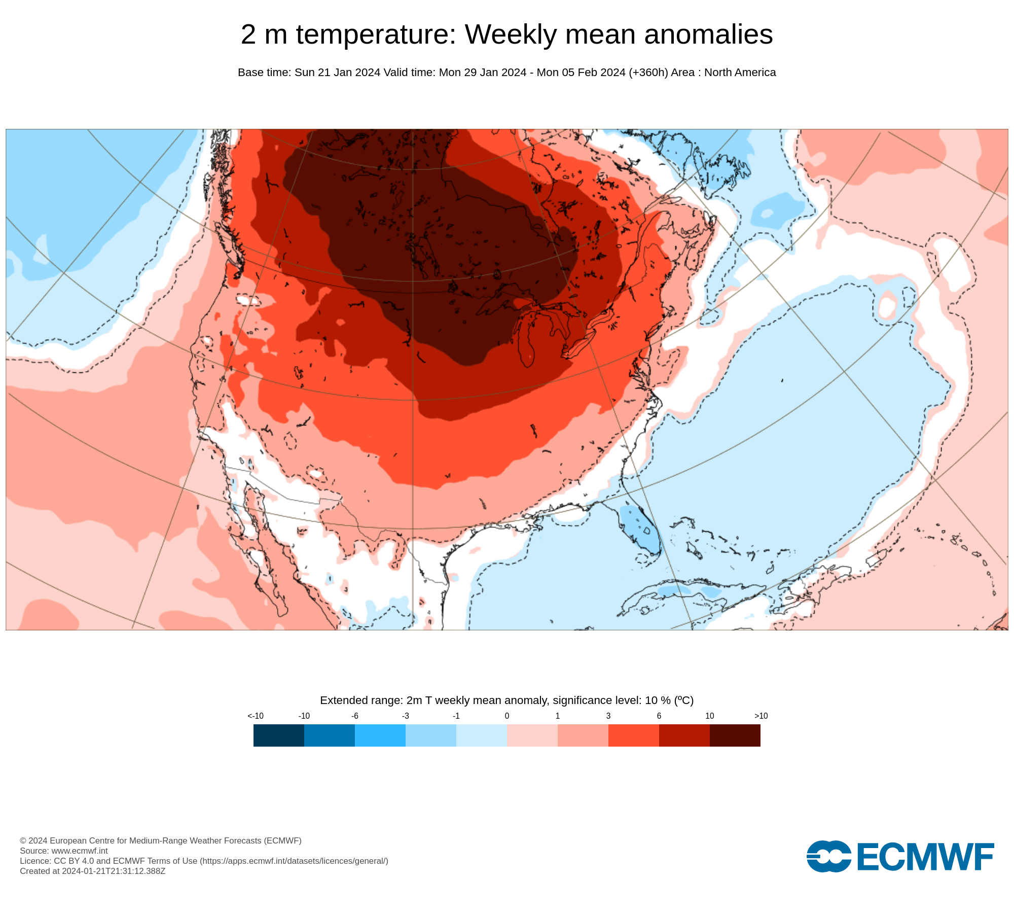
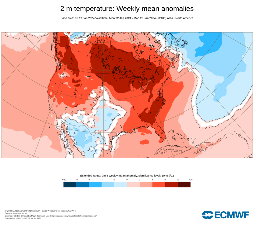
The closing 7-10 days of January will feature an EPO+/AO+ pattern. The latest EPS shows 500 mb height anomalies and surface temperature anomalies that are as close to a textbook case of what one has historically seen from such a pattern: The ECMWF Weeklies: January 22-29: This is a high confidence idea that the closing week to 10 days of January will be warmer than normal across most of North America except for Alaska, parts of the Southwest, and parts of Mexico.
-
Bias can be an issue regardless of one's position on climate change. However, objectivity requires that one consider the climate context when assessing, for example, potential analogs. All things being equal, identical 500 mb patterns will be warmer than those in the past. Thus, one can't conclude that every pattern similar to past one that brought extreme cold will bring similar magnitude cold today. Bitter cold outbreaks can still occur, but they have decreased in frequency and expanse. Patterns can also get "stuck" more often than in the past. That means warmth can persist for longer periods of time and the more limited areas of cold can persist for longer periods of time. December 2023's exceptional warmth in North America and notable cold in Scandinavia are examples of what can happen when the pattern largely becomes "stuck." Globally, of course, December 2023 was the warmest December on record on all the major datasets.