donsutherland1
-
Posts
24,194 -
Joined
Content Type
Profiles
Blogs
Forums
American Weather
Media Demo
Store
Gallery
Everything posted by donsutherland1
-
Another intense Great Lakes storm late Friday 1/12 with the brunt of 1" rain/shore gusts ~50 MPH Friday night, followed by widespread west gusts 40- possibly 50 MPH late Sat-Sun 1/13-14/2024. This serves as the OBS thread late Fri onward.
donsutherland1 replied to wdrag's topic in New York City Metro
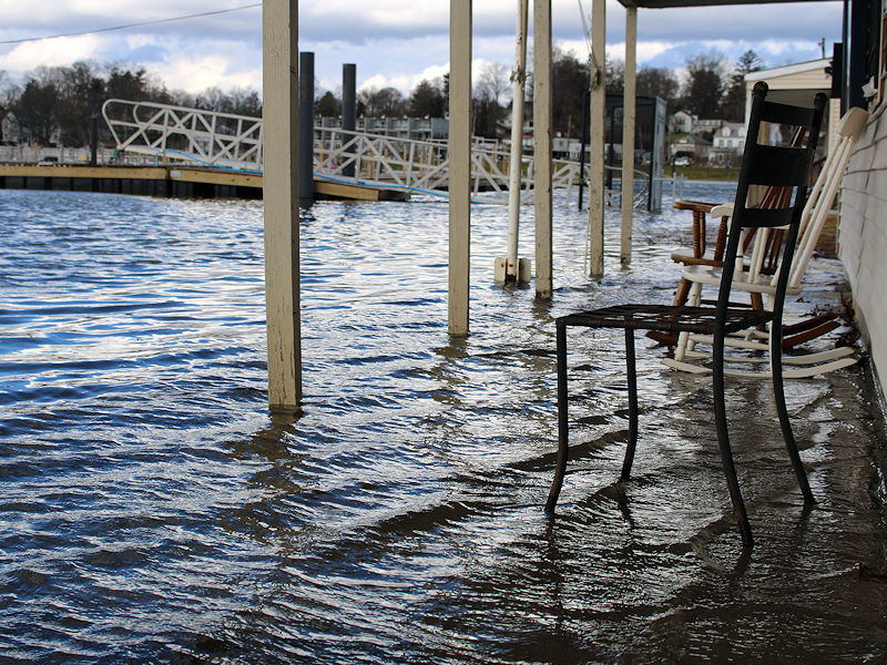
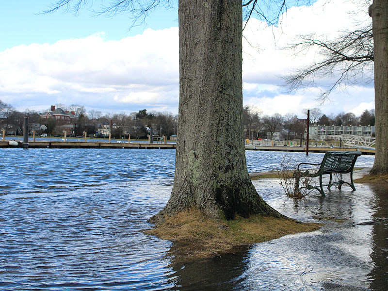
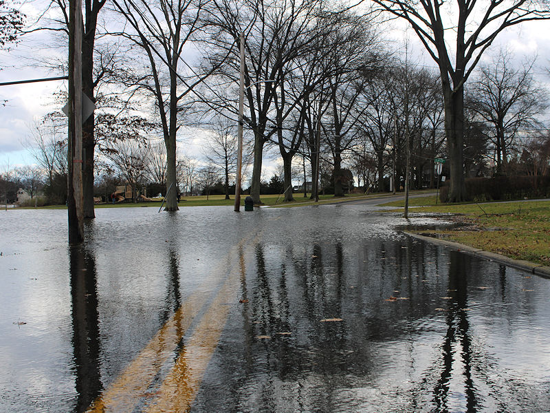
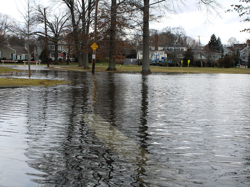
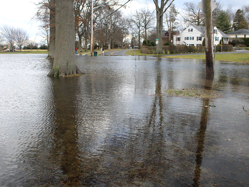
Some photos of the storm tide in Mamaroneck, NY. Some yards and basements were flooded.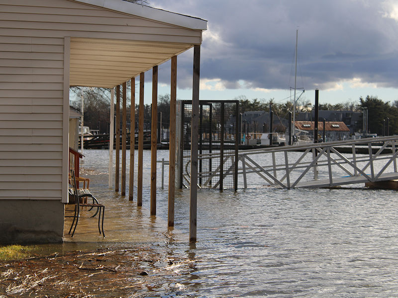
- 90 replies
-
- 7
-

-
- flooding rains
- damaging wind? squalls?
- (and 2 more)
-
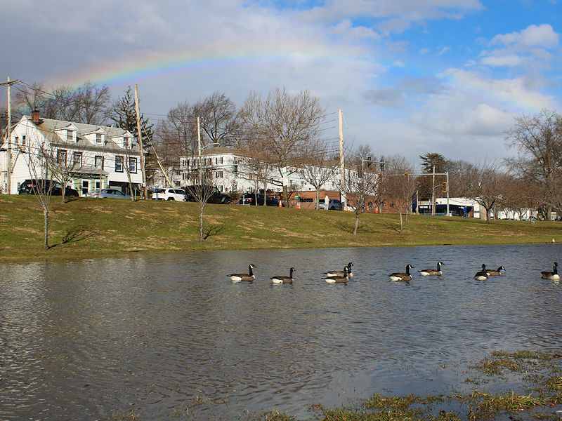
There were several sun showers and a rainbow in Mamaroneck about an hour ago.
-
Another intense Great Lakes storm late Friday 1/12 with the brunt of 1" rain/shore gusts ~50 MPH Friday night, followed by widespread west gusts 40- possibly 50 MPH late Sat-Sun 1/13-14/2024. This serves as the OBS thread late Fri onward.
donsutherland1 replied to wdrag's topic in New York City Metro
NYC: 60 at 10 am -
Overall, things remain on track for a light snow event in the northern Middle Atlantic region and a light to perhaps moderate event in southern New England. The number of EPS members showing a moderate or significant event in New York City has declined overnight. The Graphcast AI solution using the ECMWF also moved into alignment with the emerging consensus for a light event after having consistently shown a moderate/significant event. These developments fit historic experience with the forecast pattern and are consistent with the solutions on some of the higher-skill computer guidance.

-
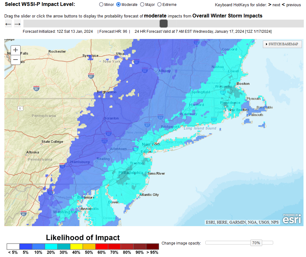
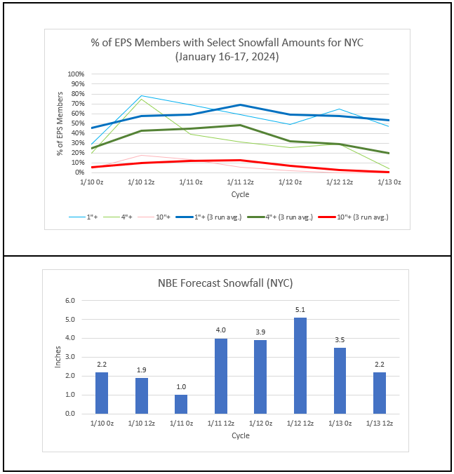
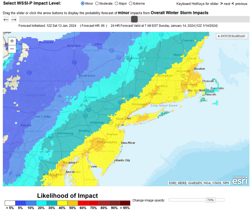
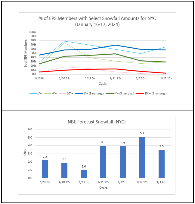
January 16-17, 2024: The complexity of the situation (which shortwave to emphasize, location and impact of the polar vortex, etc.) continued to play out in poor run-to-run continuing and lack of agreement among the guidance. That could be the case into Sunday before the guidance begins to converge and grow more consistent. Historic experience with the forecast pattern suggests that a light event would be favored in the northern Mid-Atlantic region with somewhat higher prospects for a moderate event in southern New England. Until the guidance begins to move toward consensus, it makes sense to stick with historic experience rather than riding the model roller coaster from the peaks of certain models at certain cycles to the valleys of other guidance. The WPC's probabilistic Winter Storm Severity Index shows about a 50%-60% probability of a minor impact and a 30% probability of a moderate impact (40% in parts of southern New England). For now, scenarios ranging from a moderate snowfall to little or none remain on the table. There's no need to commit to amounts this early, especially given the complexity of the pattern and resulting uncertainty.
-
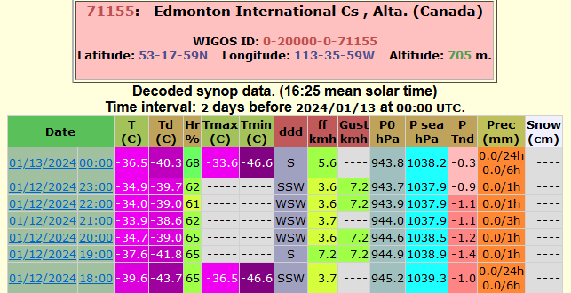
Today's frigid data from Edmonton (-46.6C/-52F):
-
Another strong storm will bring rain and wind to the region tonight into tomorrow. The storm will bring a general 0.50"-1.50" rainfall with locally higher amounts. In addition, the temperature will surge into the 50s across the region. Coastal flooding and beach erosion are likely. Winds could gust past 50 mph. Meanwhile, an Arctic air mass that saw temperatures fall as low as -56° at Watson Lake, YT and -52° at Edmononton International Airport (where the all-time low of -56° could be challenged tomorrow or Sunday) in Canada this morning, will continue to advance deeper into the Continental U.S. over coming days. This cold air will come eastward in modified fashion with the brunt of the cold never quite making it to the major cities of the northern Middle Atlantic region. The low temperature could fall into the teens in New York City during the middle of next week for the first time this season. Prospects for at least some snowfall could also increase following the coming weekend. One such opportunity exists for January 16-17. Filtering for teleconnections (AO -3.5 to -1.5, NAO-, and PNA+ as currently forecast by the GEFS), there were 9 storms that brought 2" or more snow to at least one of the following cities during January 5-25, 1950-2023: Boston, New York City, Philadelphia, or Washington, DC. Those cities fared as follows: Boston: 2" or more: 67%; 4" or more: 44%; 6" or more: 11% New York City: 2" or more: 22%; 4" or more: 11%; 6" or more: 11% Philadelphia: 2" or more: 33%; 4" or more: 11%; 6" or more: 11% Washington, DC: 2" or more: 22%; 4" or more: 11%; 6" or more: 11% The 6"+ storm was the legendary January 1996 blizzard. The situation remains complex and uncertain resulting in model divergence and a lack of run-to-run continuity. Historic data would suggest that a light snowfall remains a plausible outcome. Developments in coming days will be crucial in determining whether this latest opportunity for snowfall will be realized or if the region's snow drought will continue. Both options remain on the table. The ENSO Region 1+2 anomaly was +1.0°C and the Region 3.4 anomaly was +1.9°C for the week centered around January 3. For the past six weeks, the ENSO Region 1+2 anomaly has averaged +1.38°C and the ENSO Region 3.4 anomaly has averaged +1.97°C. A basinwide El Niño event is ongoing. The SOI was +13.10 today. The preliminary Arctic Oscillation (AO) was -2.588 today. Strong blocking in the final week of November, as occurred this year, has often been followed by frequent blocking in December and January. On January 10 the MJO was in Phase 2 at an amplitude of 1.237 (RMM). The January 9-adjusted amplitude was 1.284 (RMM). Based on sensitivity analysis applied to the latest guidance, there is an implied 59% probability that New York City will have a warmer than normal January (1991-2020 normal). January will likely finish with a mean temperature near 34.5° (0.8° above normal).
-
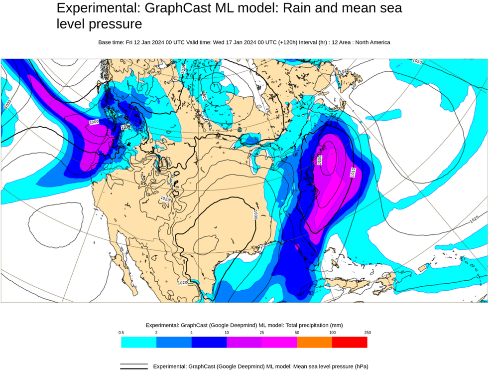
Several AI models are being run off the ECMWF. I'm not sure if AI has been integrated into the ECMWF itself. FWIW, here's the 1/12 0z Graphcast (Google AI system) run for 12-hour precipitation (snow isn't part of the test runs) through 120 hours:
-
For reference: Edmonton International Airport's all-time low: -48.3C (-55F), January 26, 1972 Edmonton Area's all-time low: -49.4C (-57F), January 19, 1886
-
For January through mid-February, the PNA is often a critical factor.
-
I agree. The sample size of these events is small, which is unfortunate. Hopefully, the guidance will move toward a more impactful snow event.
-
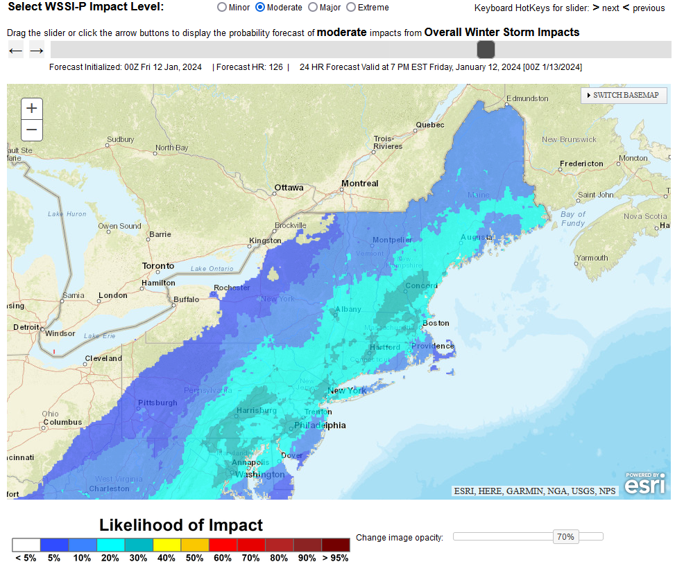
The guidance is still in its early stages regarding the potential January 16-17 snow event. The 12z ECMWF showed a complete miss to the south and east, but so far that's an outlier. Historic experience with the forecast teleconnections would favor a light event in the northern Mid-Atlantic region and potentially a light or moderate event in southern New England. There was a single case during the forecast teleconnections that saw a major event: the historic January 1996 blizzard. EPS and NBE Outcomes: The 1/12 0z Probabilistic Winter Storm Severity Index: The situation remains complex. However, the guidance should begin to converge on a solution over the next several days.

-
Another strong storm will bring rain and wind to the region later tomorrow into Saturday. The storm should bring a general 0.50"-1.50" rainfall with locally higher amounts. In addition, the temperature will again surge into the 50s across the region. Coastal flooding and beach erosion are likely. Winds could gust past 50 mph. Meanwhile, a genuine Arctic air mass will continue to advance deeper into the Continental U.S. over coming days. Severe cold is likely in the affected region. This cold air will likely come eastward in modified fashion. There is a chance that the low temperature could fall into the teens in New York City during the middle of next week. Prospects for at least some snowfall could also increase following the coming weekend. One such opportunity exists for January 16-17. Filtering for teleconnections (AO -3.5 to -1.5, NAO-, and PNA+ as currently forecast by the GEFS), there were 9 storms that brought 2" or more snow to at least one of the following cities during January 5-25, 1950-2023: Boston, New York City, Philadelphia, or Washington, DC. Those cities fared as follows: Boston: 2" or more: 67%; 4" or more: 44%; 6" or more: 11% New York City: 2" or more: 22%; 4" or more: 11%; 6" or more: 11% Philadelphia: 2" or more: 33%; 4" or more: 11%; 6" or more: 11% Washington, DC: 2" or more: 22%; 4" or more: 11%; 6" or more: 11% The 6"+ storm was the legendary January 1996 blizzard. Developments in coming days will be crucial in determining whether this latest opportunity for snowfall will be realized or if the region's snow drought will continue. Both options remain on the table. The ENSO Region 1+2 anomaly was +1.0°C and the Region 3.4 anomaly was +1.9°C for the week centered around January 3. For the past six weeks, the ENSO Region 1+2 anomaly has averaged +1.38°C and the ENSO Region 3.4 anomaly has averaged +1.97°C. A basinwide El Niño event is ongoing. The SOI was +7.73 today. The preliminary Arctic Oscillation (AO) was -2.147 today. Strong blocking in the final week of November, as occurred this year, has often been followed by frequent blocking in December and January. On January 9 the MJO was in Phase 2 at an amplitude of 1.284 (RMM). The January 8-adjusted amplitude was 0.929 (RMM). Based on sensitivity analysis applied to the latest guidance, there is an implied 63% probability that New York City will have a warmer than normal January (1991-2020 normal). January will likely finish with a mean temperature near 34.6° (0.9° above normal).
-
Upcoming storms: January 12-13: Model continuity remains good. A general 0.50"-1.50" rainfall with locally higher amounts remains likely. Strong winds gusting toward or above 50 mph, significant beach erosion, and coastal flooding are also likely. January 16-17: The guidance continues to offer a wide range of solutions. The 12z GFS shows a moderate to significant snowfall across the region. The 12z ECMWF has now suppresses the development and track of the storm well to the south and east of the region. Under the ECMWF's scenario, the regional snow drought would continue. Confidence in the development of a storm is medium. Confidence in details such as location of development, track and outcomes remains low. The NBE has taken a middle ground of sorts showing about 3" in New York City. Historically, most events in the forecast pattern have been light (<2") in the New York City and Philadelphia areas. The single exception is the Blizzard of January 1996. Odds may lean somewhat toward a lighter event than a heavy one. Overall, the situation is complex. Small changes in details concerning the synoptic pattern and short wave(s) can have a significant impact. Due to the level of uncertainty, all of the potential solutions remain on the table right now. Finally, a strong shot of cold air should advance into the region by midweek next week. New York City could see its first teens of the season.
-
Yes, but it's nothing like the GFS.
-
Lots of uncertainty still exists with regard to the potential storm. It’s too early to celebrate (GFS) or mourn (GGEM).
-
Another strong storm will bring additional rain and wind to the region Friday into Saturday. A general 0.50"-1.50" rainfall with locally higher amounts appears likely. In addition, the temperature will again surge into the 50s across the region. Coastal flooding appears likely. Meanwhile, a genuine Arctic air mass will be slowly advancing into the Pacific Northwest and Northern Plains. Severe cold is likely in the affected region. Afterward, this cold air could come eastward in modified fashion. That could set the stage for the coldest period so far this winter beginning on Sunday or Monday. There is a chance that the low temperature could fall into the teens in New York City during the middle of next week. Prospects for at least some snowfall could increase after the weekend. One such opportunity exists for January 16-17. Filtering for teleconnections (AO -3.5 to -1.5, NAO-, and PNA+ as currently forecast by the GEFS), there were 9 storms that brought 2" or more snow to at least one of the following cities during January 5-25, 1950-2023: Boston, New York City, Philadelphia, or Washington, DC. Those cities fared as follows: Boston: 2" or more: 67%; 4" or more: 44%; 6" or more: 11% New York City: 2" or more: 22%; 4" or more: 11%; 6" or more: 11% Philadelphia: 2" or more: 33%; 4" or more: 11%; 6" or more: 11% Washington, DC: 2" or more: 22%; 4" or more: 11%; 6" or more: 11% The 6"+ storm was the legendary January 1996 blizzard. Developments in coming days will be crucial in determining whether this latest opportunity for snowfall will be realized or if the region's snow drought will continue. For now, nothing is cast in stone, as can be seen from the dramatic differences between the January 10 12z and 18z runs of the GFS Model. The ENSO Region 1+2 anomaly was +1.0°C and the Region 3.4 anomaly was +1.9°C for the week centered around January 3. For the past six weeks, the ENSO Region 1+2 anomaly has averaged +1.38°C and the ENSO Region 3.4 anomaly has averaged +1.97°C. A basinwide El Niño event is ongoing. The SOI was +1.51 today. The preliminary Arctic Oscillation (AO) was -1.212 today. Strong blocking in the final week of November, as occurred this year, has often been followed by frequent blocking in December and January. Through January 10th, the AO has been negative on 66% of days and at or below -1.000 on 49% of days. On January 8 the MJO was in Phase 3 at an amplitude of 0.929 (RMM). The January 7-adjusted amplitude was 1.261 (RMM). Based on sensitivity analysis applied to the latest guidance, there is an implied 60% probability that New York City will have a warmer than normal January (1991-2020 normal). January will likely finish with a mean temperature near 34.5° (0.8° above normal).
-
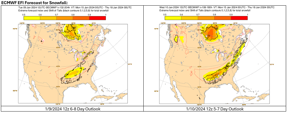
Ensemble support for a possible January 16-17, 2024 snow event has increased among the EPS members. The ECMWF's Extreme Forecast Index (EFI) snowfall forecast has also improved for the timeframe over the past 24 hours. These are encouraging developments, but it is premature to reach concrete and detailed conclusions about the possible event.
-
There was a nice improvement on the 12z GFS and GGEM runs. All of the region picks up a light snowfall for 1/16-17 on the guidance, parts of New England see a moderate snowfall. The GGEM has a more robust solution. There still remains considerable uncertainty. Hopefully, continuity and consistency among the guidance can develop over the next few days.
-
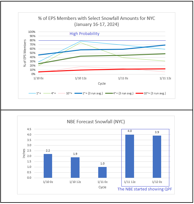
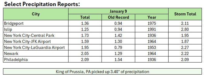
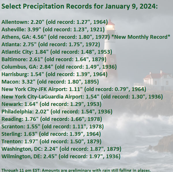
The January 9-10, 2024 storm behaved quite well relative to expectations. Much of the region saw a general 1"-3" rainfall with some locally higher amounts. Winds gusted as high as 72 mph in the region. Another significant storm will affect the region later this week. January 12-13, 2024: Confidence in the storm remains high. An intensifying storm will bring moderate to heavy rain to the region (generally 0.50"-1.50" with some locally higher amounts of 2.00" or more). Gusty winds and coastal flooding are likely. The temperature will again surge into the 50s across the region. The same storm will bring Chicago a 6"-12" snowfall with potentially more. January 16-18, 2024: Low-to-Medium Confidence: Generally, the ECMWF had been hinting at a significant snowstorm during this range. Unlike with the January 6-7 event that was a very low ratio snowfall in parts of the region except well north and west of New York City and Newark, this storm would likely feature more typical ratios as per the guidance with the snowy outcomes. A few GFS runs subsequently picked up on the storm (as primarily a snowstorm) but the model abandoned that idea afterward. Overall, support for the snowstorm idea has not been strong or consistent. Ensemble support has recently decreased. On the 1/10 0z EPS, 29% of members had 1" or more snow in New York City while 20% had 4" or more. The 3-cycle averages were 46% and 25% respectively. At present, it is somewhat more likely than not that the New York City and Philadelphia areas won't see a moderate or greater snowstorm. It's a closer call for the Boston area. The arrival of the season's coldest weather so far by the middle of next week remains on course. New York City could see its low temperatures fall into the lower 20s or even the teens at the height of the cold. Elsewhere, Buffalo will end its record stretch without a low temperature in the teens, which will reach 319 days today. In doing so, Buffalo will record its latest first teens of the season. The old record was January 3 during winters 2015-16 and 2021-22. Four of Buffalo's five first teens in January (2023-24 is counted) have occurred since winter 2000-01. Buffalo's seasonal records go back to winter 1874-75.
-
Two Mdt to high impact events NYC subforum; wknd Jan 6-7 Incl OBS, and mid week Jan 9-10 (incl OBS). Total water equiv by 00z/11 general 2", possibly 6" includes snow-ice mainly interior. RVR flood potential increases Jan 10 and beyond. Damaging wind.
donsutherland1 replied to wdrag's topic in New York City Metro
Happy birthday.- 3,610 replies
-
- 1
-
-
- snow
- heavy rain
- (and 5 more)
-
Two Mdt to high impact events NYC subforum; wknd Jan 6-7 Incl OBS, and mid week Jan 9-10 (incl OBS). Total water equiv by 00z/11 general 2", possibly 6" includes snow-ice mainly interior. RVR flood potential increases Jan 10 and beyond. Damaging wind.
donsutherland1 replied to wdrag's topic in New York City Metro
Happy birthday in advance.- 3,610 replies
-
- 2
-
-
- snow
- heavy rain
- (and 5 more)
-
Two Mdt to high impact events NYC subforum; wknd Jan 6-7 Incl OBS, and mid week Jan 9-10 (incl OBS). Total water equiv by 00z/11 general 2", possibly 6" includes snow-ice mainly interior. RVR flood potential increases Jan 10 and beyond. Damaging wind.
donsutherland1 replied to wdrag's topic in New York City Metro
1 S Mamaroneck, NY recently recorded a 64 mph gust. -
Two Mdt to high impact events NYC subforum; wknd Jan 6-7 Incl OBS, and mid week Jan 9-10 (incl OBS). Total water equiv by 00z/11 general 2", possibly 6" includes snow-ice mainly interior. RVR flood potential increases Jan 10 and beyond. Damaging wind.
donsutherland1 replied to wdrag's topic in New York City Metro
- 3,610 replies
-
- 1
-
-
- snow
- heavy rain
- (and 5 more)
-
Two Mdt to high impact events NYC subforum; wknd Jan 6-7 Incl OBS, and mid week Jan 9-10 (incl OBS). Total water equiv by 00z/11 general 2", possibly 6" includes snow-ice mainly interior. RVR flood potential increases Jan 10 and beyond. Damaging wind.
donsutherland1 replied to wdrag's topic in New York City Metro
Atlantic City has had gusts of 56 mph so far. 1 NE Brigantine, NJ had a 62 mph gust at 8:39 pm. JFK's 0.86" rainfall so far breaks the January 9th record of 0.79" from 1964.