

donsutherland1
-
Posts
24,194 -
Joined
Content Type
Profiles
Blogs
Forums
American Weather
Media Demo
Store
Gallery
Everything posted by donsutherland1
-
Two Mdt to high impact events NYC subforum; wknd Jan 6-7 Incl OBS, and mid week Jan 9-10 (incl OBS). Total water equiv by 00z/11 general 2", possibly 6" includes snow-ice mainly interior. RVR flood potential increases Jan 10 and beyond. Damaging wind.
donsutherland1 replied to wdrag's topic in New York City Metro
Probably 3”-5” (more at higher elevations).- 3,610 replies
-
- 2
-

-
- snow
- heavy rain
- (and 5 more)
-
Two Mdt to high impact events NYC subforum; wknd Jan 6-7 Incl OBS, and mid week Jan 9-10 (incl OBS). Total water equiv by 00z/11 general 2", possibly 6" includes snow-ice mainly interior. RVR flood potential increases Jan 10 and beyond. Damaging wind.
donsutherland1 replied to wdrag's topic in New York City Metro
Hopefully, that scenario will play out. -
Two Mdt to high impact events NYC subforum; wknd Jan 6-7 Incl OBS, and mid week Jan 9-10 (incl OBS). Total water equiv by 00z/11 general 2", possibly 6" includes snow-ice mainly interior. RVR flood potential increases Jan 10 and beyond. Damaging wind.
donsutherland1 replied to wdrag's topic in New York City Metro
I don’t know how the maps are programmed. -
Two Mdt to high impact events NYC subforum; wknd Jan 6-7 Incl OBS, and mid week Jan 9-10 (incl OBS). Total water equiv by 00z/11 general 2", possibly 6" includes snow-ice mainly interior. RVR flood potential increases Jan 10 and beyond. Damaging wind.
donsutherland1 replied to wdrag's topic in New York City Metro
The GFS shows snow at HPN until near 42 hours. Then, there's at least some sleet mixing in. Surface temperatures are above freezing, though.- 3,610 replies
-
- 2
-

-
- snow
- heavy rain
- (and 5 more)
-
Two Mdt to high impact events NYC subforum; wknd Jan 6-7 Incl OBS, and mid week Jan 9-10 (incl OBS). Total water equiv by 00z/11 general 2", possibly 6" includes snow-ice mainly interior. RVR flood potential increases Jan 10 and beyond. Damaging wind.
donsutherland1 replied to wdrag's topic in New York City Metro
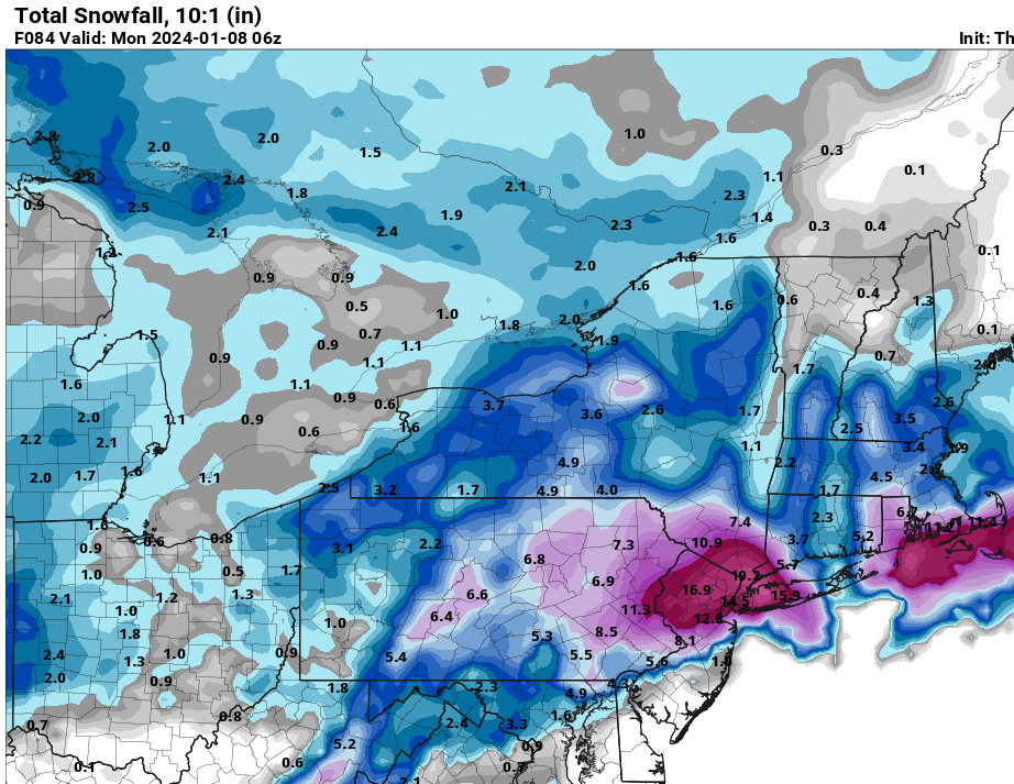
Reminder: Avoid 10:1 Snow Maps. Go to the Soundings. Latest illustration: 12z GFS at 36 hours. The maps show moderate to heavy snow at JFK. The sounding supports rain. The column is above freezing until one reaches 925 mb. The surface temperature is 38°. Based on the soundings, JFK has little or no accumulation of snow rather than the amounts shown on the 10:1 maps. I highlighted the 0°C line for ease of viewing.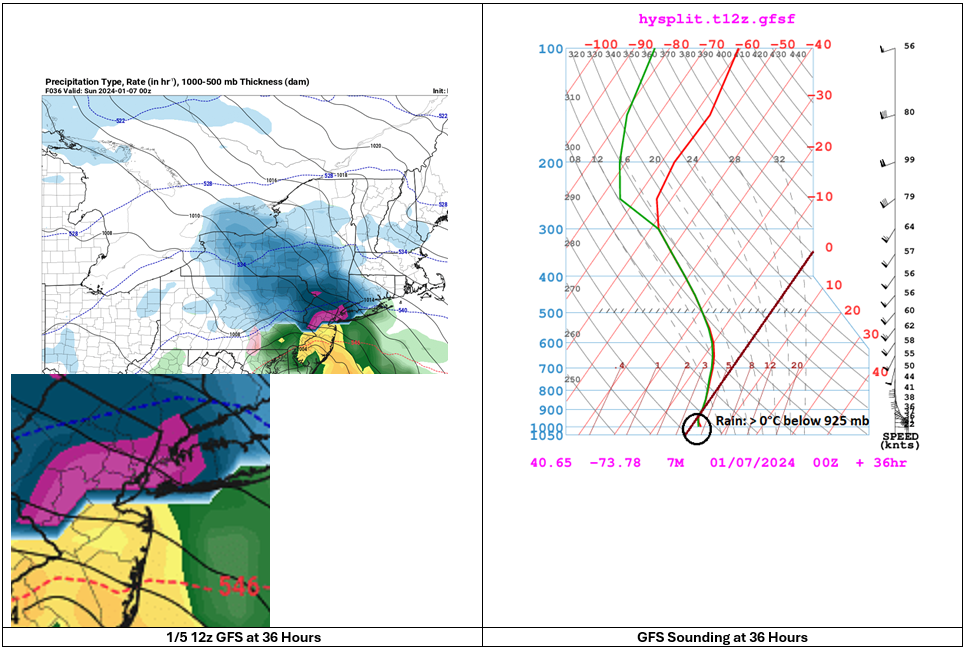
- 3,610 replies
-
- 7
-
-
-
- snow
- heavy rain
- (and 5 more)
-
Two Mdt to high impact events NYC subforum; wknd Jan 6-7 Incl OBS, and mid week Jan 9-10 (incl OBS). Total water equiv by 00z/11 general 2", possibly 6" includes snow-ice mainly interior. RVR flood potential increases Jan 10 and beyond. Damaging wind.
donsutherland1 replied to wdrag's topic in New York City Metro
HREF through 1/7 12z: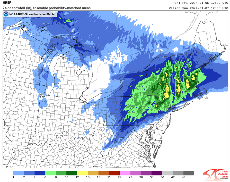
- 3,610 replies
-
- 2
-
-
- snow
- heavy rain
- (and 5 more)
-
Two Mdt to high impact events NYC subforum; wknd Jan 6-7 Incl OBS, and mid week Jan 9-10 (incl OBS). Total water equiv by 00z/11 general 2", possibly 6" includes snow-ice mainly interior. RVR flood potential increases Jan 10 and beyond. Damaging wind.
donsutherland1 replied to wdrag's topic in New York City Metro
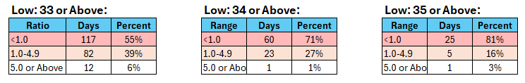
Distribution of Daily Snowfall Amounts by Minimum Temperature with Total Precipitation of 0.50" or More and Measurable Snowfall: Distribution of Event Average Snow-to-Liquid Ratios: The mean event average snow-to-liquid ratio was 1.4 (standard deviation: 1.5). The lowest was near 0. The highest was 9.2. This data was taken from the combined climate records for Bridgeport, Islip, New York City, Newark, and Philadelphia. At present, it appears that Central Park's low temperature during the precipitation will likely be 34° or above. NAM and GFS MOS: 34°. NBE: 36° +/- 3°. This historic data also argues for a low ratio and light accumulation of snow for New York City.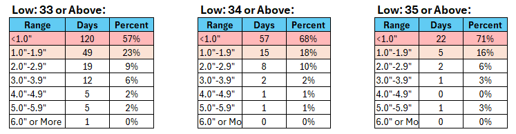
-
Two Mdt to high impact events NYC subforum; wknd Jan 6-7 Incl OBS, and mid week Jan 9-10 (incl OBS). Total water equiv by 00z/11 general 2", possibly 6" includes snow-ice mainly interior. RVR flood potential increases Jan 10 and beyond. Damaging wind.
donsutherland1 replied to wdrag's topic in New York City Metro
National Blend of Models Output (0z and 12z cycles): The 1/5 14z run decreased a little more to 0.5". It shows a minimum temperature of 36° during the precipitation. Any snow that falls in the NYC area will be low- to very low-ratio snow.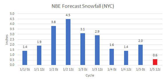
- 3,610 replies
-
- 1
-
-
- snow
- heavy rain
- (and 5 more)
-
Two Mdt to high impact events NYC subforum; wknd Jan 6-7 Incl OBS, and mid week Jan 9-10 (incl OBS). Total water equiv by 00z/11 general 2", possibly 6" includes snow-ice mainly interior. RVR flood potential increases Jan 10 and beyond. Damaging wind.
donsutherland1 replied to wdrag's topic in New York City Metro
In the past, I used to ignore it. But the problem has become so widespread that I now call them out. It's unfortunate, as it really takes time that I'd prefer to be doing some other things.- 3,610 replies
-
- 3
-
-
- snow
- heavy rain
- (and 5 more)
-
Two Mdt to high impact events NYC subforum; wknd Jan 6-7 Incl OBS, and mid week Jan 9-10 (incl OBS). Total water equiv by 00z/11 general 2", possibly 6" includes snow-ice mainly interior. RVR flood potential increases Jan 10 and beyond. Damaging wind.
donsutherland1 replied to wdrag's topic in New York City Metro
Those maps are a huge problem. I've increasingly starting calling out and verifying the extreme maps posted on Twitter. Those posts provide no useful guidance and only serve to undermine professional credibility of meteorologists, many of whom are outstanding, but whose insights and forecasts are drowned out by the noise of the extreme posts, blind rush to be first to make a call, etc. Indeed, a female TV meteorologist from Philadelphia was criticized on social media for not making an early call for snowfall amounts when uncertainty was high. She made a forecast for a coating to an inch in Philadelphia yesterday (her first call). That looks good. Contrast that to the social media maps showing 4"-8" or even 4"-12" in Philadelphia that dated as far back as January 1. Quite bluntly, those who consistently post extreme solutions or earliest calls but wind up wrong over and over again lack skill. They can spin it any way they like, but skill is a function of consistent accuracy. Nothing more. Unfortunately, the public and those who read social media don't realize the absence of skill among those who take sensationalist stands. Thus, the misleading perception that meteorologists 'can't forecast' prevails even as those perceptions are far off the mark.- 3,610 replies
-
- 6
-
-
-
- snow
- heavy rain
- (and 5 more)
-
Two Mdt to high impact events NYC subforum; wknd Jan 6-7 Incl OBS, and mid week Jan 9-10 (incl OBS). Total water equiv by 00z/11 general 2", possibly 6" includes snow-ice mainly interior. RVR flood potential increases Jan 10 and beyond. Damaging wind.
donsutherland1 replied to wdrag's topic in New York City Metro
In terms of the concern about "waffling," there was a lot of good analysis provided by numerous people. Wdrag, Bluewave, Dark Star, among others, provided good insight. Others provided good arguments why the event could be better. It should be noted that people can provide good insight and still be wrong in the end. Forecasting is inherently uncertain and all who engage in it encounter error from time to time. From my vantage point (which has been wrong at times and will again be wrong), there were persistent "red flags" that urged caution from the onset: Overall synoptic pattern, persistent surface temperature projections, emergent soundings data, and risks associated with extreme outlier solutions that lacked strong support. For illustrative purposes to show how these "red flags" came into play, excerpts from some posts follow. One should also read through Bluewave's posts, as he consistently raised issues that are now playing out e.g., the impact of the upstream trough in the Southwest. January 3: Of concern remains surface temperatures that will be above freezing for most or all of the event. Soundings will become increasingly important as the event draws closer, but this still looks to be a wet, low ratio snowfall for NYC and its nearby suburbs. January 3: The importance of recognizing that the upcoming event will be a low- to very low-ratio event in New York City cannot be overstated. Most of the guidance keeps NYC above freezing throughout the storm. While model solutions showing 6"+ snow appear attractive, the early surface temperature forecasts and early soundings suggest that such figures based on a 10:1 ratio will likely be far off the mark. January 4: There was more downside risk than upside risk. Unfortunately, even at this point in time, there still remains somewhat more downside risk than upside risk, namely that the 1" of slushy snow to perhaps 3", if everything went well, could evolve into a coating to an inch-type scenario. The low ratios (high confidence assumption given the consistently forecast temperatures) rendered 10:1 snowfall maps irrelevant. That included individual ensemble maps based on 10:1 ratios. In both cases, the operational and ensemble maps overstated what was likely. For an illustrative example, maps assessing the probability of 4" or more snowfall were actually assessing the probability of 2" or more snow in and around NYC and along the coastal plain, because their 10:1 ratios were not realistic. As a result of the overnight guidance, the probability that New York City's streak without 1" or more daily snowfall, which will reach 690 days today, will continue has increased. January 4: Be wary of snow maps e.g., the 18z NAM's depictions... A significant share of the precipitation is rain or mixed precipitation, not snow. For example, at 75 hours when the NAM is piling on the digital snow, the sounding shows the above freezing layer extending almost to 975 mb with above-freezing surface temperatures. Over New York City's urban heat island, that's not accumulating snow. The precipitation ends as snow, but accumulations will likely be limited. Outlier models for heavy snowfall that lack support should be disregarded given the marginal air mass and historic experience with snowfall at above freezing temperatures in New York City.- 3,610 replies
-
- 10
-
-
-
- snow
- heavy rain
- (and 5 more)
-
I don't know about the timing, as sometimes the guidance rushes things, but I am highly confident that we will get in the teens this winter (probably second half of this month).
-
Two Mdt to high impact events NYC subforum; wknd Jan 6-7 Incl OBS, and mid week Jan 9-10 (incl OBS). Total water equiv by 00z/11 general 2", possibly 6" includes snow-ice mainly interior. RVR flood potential increases Jan 10 and beyond. Damaging wind.
donsutherland1 replied to wdrag's topic in New York City Metro
Overnight, the NAM finally "woke up" to reality in abandoning its high snowfall amounts that were not supported by its own soundings. The guidance also consolidated toward a minor event in the NYC area and a moderate event well north and west of the City i.e., West Milford, Goshen, Danbury, etc. The coating to 1" scenario for Central Park remains on the table. In fact, the 11z NBE now shows just 0.6" in the Park. The <1" daily snowfall streak will reach 691 days today and could continue through the upcoming storm. Next week's rain and wind storm will be a much higher-impact event for the region.- 3,610 replies
-
- 4
-
-
-
- snow
- heavy rain
- (and 5 more)
-
No. Winter 2001-02 came closest with a minimum temperature of 19.
-
Two Mdt to high impact events NYC subforum; wknd Jan 6-7 Incl OBS, and mid week Jan 9-10 (incl OBS). Total water equiv by 00z/11 general 2", possibly 6" includes snow-ice mainly interior. RVR flood potential increases Jan 10 and beyond. Damaging wind.
donsutherland1 replied to wdrag's topic in New York City Metro
The 2.0” figure I showed was for Central Park, not JFK. I commented on JFK, because soundings are available for JFK. Sorry about any confusion. -
Two Mdt to high impact events NYC subforum; wknd Jan 6-7 Incl OBS, and mid week Jan 9-10 (incl OBS). Total water equiv by 00z/11 general 2", possibly 6" includes snow-ice mainly interior. RVR flood potential increases Jan 10 and beyond. Damaging wind.
donsutherland1 replied to wdrag's topic in New York City Metro
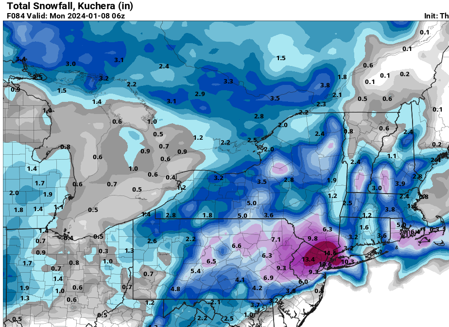
Latest EPS and NBE information: Be wary of snow maps e.g., the 18z NAM's depictions below: A significant share of the precipitation is rain or mixed precipitation, not snow. For example, at 75 hours when the NAM is piling on the digital snow, the sounding shows the above freezing layer extending almost to 975 mb with above-freezing surface temperatures. Over New York City's urban heat island, that's not accumulating snow. The precipitation ends as snow, but accumulations will likely be limited. Outlier models for heavy snowfall that lack support should be disregarded given the marginal air mass and historic experience with snowfall at above freezing temperatures in New York City.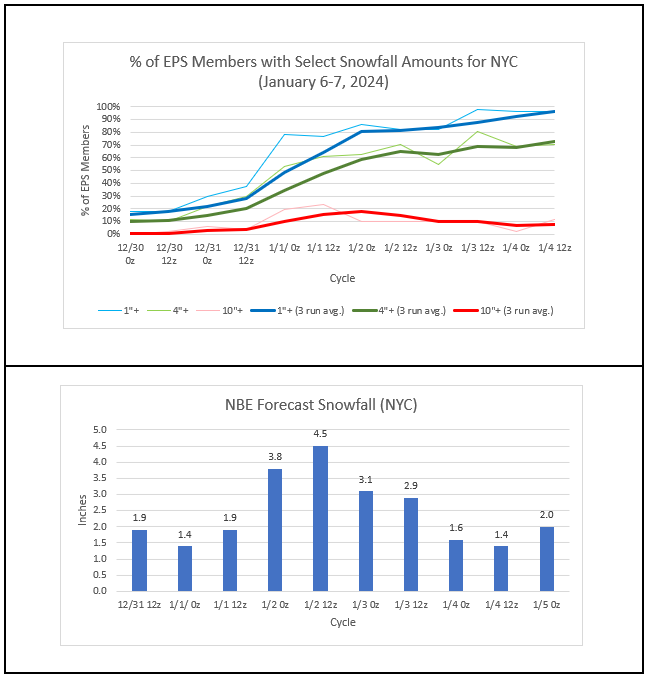
- 3,610 replies
-
- 5
-
-
- snow
- heavy rain
- (and 5 more)
-
Generally dry weather will continue through tomorrow. Afterward, a series of storms will impact the region. A storm will bring measurable snowfall to parts of the region Saturday afternoon into Sunday. This appears to be the kind of storm that could bring a general 1" to perhaps 3" of slushy snow to New York City (lowest amounts in Queens, Brooklyn, and Staten Island and highest amounts in the Bronx) with 3"-6" of snow well north and west of New York City. The probability of a significant (6" or greater) snowfall in Boston has increased. There remains a degree of uncertainty in coastal regions, including the New York City area. Following the region's first winter storm, a major storm could bring a heavy windswept rain to much of the region during the middle of next week. The potential exists for a 1"-3" rainfall with locally higher amounts. Temperatures could surge toward or into the 50s. The ENSO Region 1+2 anomaly was +0.8°C and the Region 3.4 anomaly was +2.0°C for the week centered around December 27. For the past six weeks, the ENSO Region 1+2 anomaly has averaged +1.55°C and the ENSO Region 3.4 anomaly has averaged +2.00°C. A basinwide El Niño event is ongoing. The SOI was -5.74 today. The preliminary Arctic Oscillation (AO) was -0.696 today. Strong blocking in the final week of November, as occurred this year, has often been followed by frequent blocking in December and January. On January 2 the MJO was in Phase 2 at an amplitude of 2.276 (RMM). The January 1-adjusted amplitude was 1.959 (RMM).
-
Two Mdt to high impact events NYC subforum; wknd Jan 6-7 Incl OBS, and mid week Jan 9-10 (incl OBS). Total water equiv by 00z/11 general 2", possibly 6" includes snow-ice mainly interior. RVR flood potential increases Jan 10 and beyond. Damaging wind.
donsutherland1 replied to wdrag's topic in New York City Metro
- 3,610 replies
-
- 2
-
-
-
- snow
- heavy rain
- (and 5 more)
-
Two Mdt to high impact events NYC subforum; wknd Jan 6-7 Incl OBS, and mid week Jan 9-10 (incl OBS). Total water equiv by 00z/11 general 2", possibly 6" includes snow-ice mainly interior. RVR flood potential increases Jan 10 and beyond. Damaging wind.
donsutherland1 replied to wdrag's topic in New York City Metro
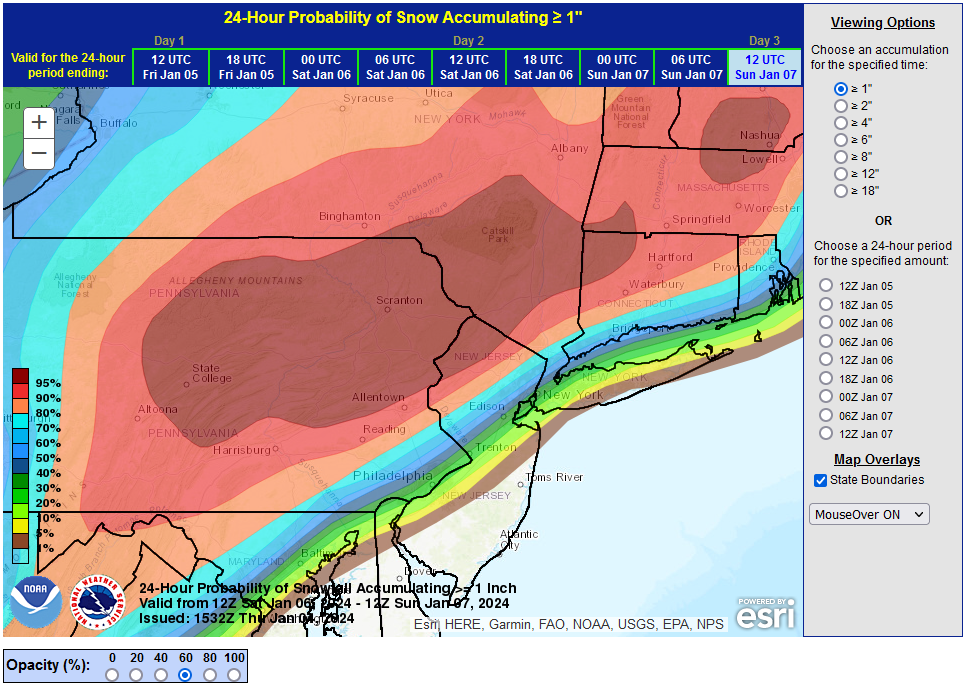
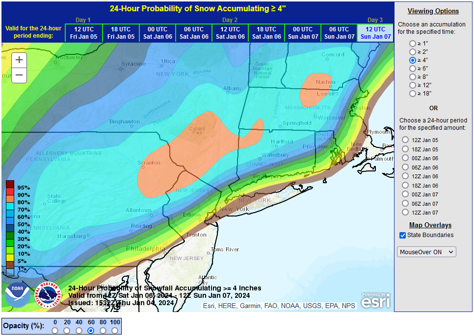
Overnight, the guidance began to consolidate toward a scenario where snowfall is limited in the New York City area with appreciable amounts (4"+) occurring only well north and west of the City. The 1/4 6z GFS soundings were brutal. A meaningful share of the precipitation e.g., between 72 hours-75 hours would fall as rain. The 1/4 12z NBE's estimated snowfall for the City was 1.4" at Central Park, 1.1" at LaGuardia Airport, and 0.6" at JFK Airport. Temperatures are currently forecast to remain above freezing throughout the storm in New York City leading to very low ratios. Historic data for January 1-15, 1869-2023 with low temperatures above freezing highlighted the issue of low ratios. With some of the guidance now showing a low of 35° or above, a wider look at all cases revealed that just 26% of such cases saw 1" or more snowfall while 74% saw less than 1" of snow (Mean: 0.8"; Median: 0.5"). The mean figure was skewed by April 9, 1907 (5.0") and November 9, 1892 (2.3") snowfalls. In both cases the snow fell very heavily over a short period of time. Such dynamics are not likely this time around. With the strong short wave digging into the Southwest, this kind of solution was a danger. There was more downside risk than upside risk. Unfortunately, even at this point in time, there still remains somewhat more downside risk than upside risk, namely that the 1" of slushy snow to perhaps 3", if everything went well, could evolve into a coating to an inch-type scenario. The low ratios (high confidence assumption given the consistently forecast temperatures) rendered 10:1 snowfall maps irrelevant. That included individual ensemble maps based on 10:1 ratios. In both cases, the operational and ensemble maps overstated what was likely. For an illustrative example, maps assessing the probability of 4" or more snowfall were actually assessing the probability of 2" or more snow in and around NYC and along the coastal plain, because their 10:1 ratios were not realistic. As a result of the overnight guidance, the probability that New York City's streak without 1" or more daily snowfall, which will reach 690 days today, will continue has increased. However, even as the New York City area will have to wait for another storm for the opportunity for a moderate or significant snowfall, it should be noted that 75% of seasonal snowfall during strong El Niño winters falls after January 15th and around 50% falls on or after February 1st. Therefore, it is likely that there will be additional opportunities as the current winter progresses deeper into January and then beyond.- 3,610 replies
-
- 7
-
-
-
- snow
- heavy rain
- (and 5 more)
-
Two Mdt to high impact events NYC subforum; wknd Jan 6-7 Incl OBS, and mid week Jan 9-10 (incl OBS). Total water equiv by 00z/11 general 2", possibly 6" includes snow-ice mainly interior. RVR flood potential increases Jan 10 and beyond. Damaging wind.
donsutherland1 replied to wdrag's topic in New York City Metro
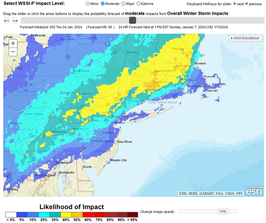
Latest EPS and NBE information: Note: EPS amounts are based on 10:1 ratios. The actual ratios in NYC could be closer to 4:1 to 6:1 given that readings could remain several degrees above freezing throughout most or even all of the storm. In fact, the NBE shows < 0.5" at JFK Airport. WPC's probabilistic Winter Storm Severity Index: Probability of a moderate impact: It is possible that the 1"+ daily snowfall droughts could continue in parts of the region. Baltimore and Philadelphia are at highest risk, but there is a non-negligible risk at Central Park. The overnight 0z model runs or tomorrow's model cycles could begin to converge toward a consensus. Uncertainty remains higher than usual given the marginal air mass involved and impact that small changes in the track could have on where the precipitation is predominantly liquid or predominantly frozen.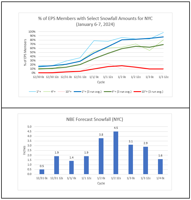
- 3,610 replies
-
- 1
-
-
- snow
- heavy rain
- (and 5 more)
-
Generally cool, dry weather will continue through the remainder of the week. A few locations could see a rain or snow shower tomorrow morning. Overall, the first week of January remains in line for somewhat above normal temperatures. A storm could bring measurable snowfall to parts of the region Saturday afternoon into Sunday. There are currently two leading scenarios. The first involves significant snow (6" or more) falling well north and west of an area that includes Philadelphia and New York City. The second involves significant snowfall extending south and east into the area that includes New York City and Philadelphia. The first scenario is currently more likely than the second. The probability of such an outcome has increased over the past 24 hours. Details remain to be worked out. However, this appears to be the kind of storm that could bring a general 1" to perhaps 3" of slushy snow to New York City (lowest amounts in Queens, Brooklyn, and Staten Island and highest amounts in the Bronx) with 3"-6" of snow well north and west of New York City. Afterward, a major storm could bring a heavy windswept rain to much of the region during the middle of next week. The potential exists for a 1"-3" rainfall with locally higher amounts. Temperatures could surge toward or into the 50s. The ENSO Region 1+2 anomaly was +0.8°C and the Region 3.4 anomaly was +2.0°C for the week centered around December 27. For the past six weeks, the ENSO Region 1+2 anomaly has averaged +1.55°C and the ENSO Region 3.4 anomaly has averaged +2.00°C. A basinwide El Niño event is ongoing. The SOI was +0.81 today. The preliminary Arctic Oscillation (AO) was -1.127 today. Strong blocking in the final week of November, as occurred this year, has often been followed by frequent blocking in December and January. On January 1 the MJO was in Phase 2 at an amplitude of 1.959 (RMM). The December 31-adjusted amplitude was 1.894 (RMM).
-
Two Mdt to high impact events NYC subforum; wknd Jan 6-7 Incl OBS, and mid week Jan 9-10 (incl OBS). Total water equiv by 00z/11 general 2", possibly 6" includes snow-ice mainly interior. RVR flood potential increases Jan 10 and beyond. Damaging wind.
donsutherland1 replied to wdrag's topic in New York City Metro
From NWS-New York: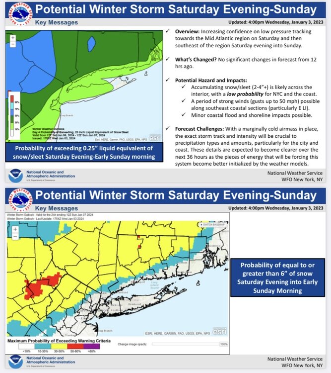
- 3,610 replies
-
- 3
-
-
- snow
- heavy rain
- (and 5 more)
-
Two Mdt to high impact events NYC subforum; wknd Jan 6-7 Incl OBS, and mid week Jan 9-10 (incl OBS). Total water equiv by 00z/11 general 2", possibly 6" includes snow-ice mainly interior. RVR flood potential increases Jan 10 and beyond. Damaging wind.
donsutherland1 replied to wdrag's topic in New York City Metro
From NWS Boston:
- 3,610 replies
-
- 3
-
-
- snow
- heavy rain
- (and 5 more)
-
Two Mdt to high impact events NYC subforum; wknd Jan 6-7 Incl OBS, and mid week Jan 9-10 (incl OBS). Total water equiv by 00z/11 general 2", possibly 6" includes snow-ice mainly interior. RVR flood potential increases Jan 10 and beyond. Damaging wind.
donsutherland1 replied to wdrag's topic in New York City Metro
And some wind up posting exaggerated snowfall totals from such maps on Social Media which creates real headaches for the professional community. It creates perceptions that the professional community of private- and public-sector meteorologists are "wrong" when the exaggerated amounts don't verify, as is typically the case for extreme solutions that have little support. Such maps are starting to be called out more frequently on social media. But there is no sign yet that the pushing of reckless speculation is slowing. One such map: If everything went right, Allentown would have a shot at 6"-12", but right now 4"-8" seems likely (downside risk is greater than upside risk). The latest NBE forecast is for just under 6" there.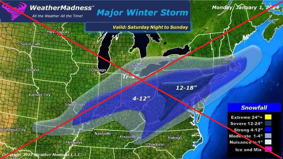
- 3,610 replies
-
- 4
-
-
- snow
- heavy rain
- (and 5 more)
-
Two Mdt to high impact events NYC subforum; wknd Jan 6-7 Incl OBS, and mid week Jan 9-10 (incl OBS). Total water equiv by 00z/11 general 2", possibly 6" includes snow-ice mainly interior. RVR flood potential increases Jan 10 and beyond. Damaging wind.
donsutherland1 replied to wdrag's topic in New York City Metro
This page explains it and has some links to more detailed discussions: https://home.pivotalweather.com/guides/snowfall- 3,610 replies
-
- 8
-
-
- snow
- heavy rain
- (and 5 more)


