-
Posts
23,892 -
Joined
Content Type
Profiles
Blogs
Forums
American Weather
Media Demo
Store
Gallery
Everything posted by donsutherland1
-
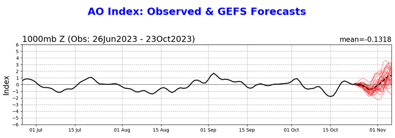
The tendency toward a strengthening SPV may be starting to show up in the extended range of the AO forecast, which is now showing a pronounced rise.
-
Tomorrow through Tuesday will be chilly late autumnlike days. Some frost will be possible in areas outside New York City and Newark. However, by the middle of the week, temperatures will surge to above and much above normal levels. During the peak of the warmth, the temperature will likely reach 70° or above as far north as southern New England. Parts of the Middle Atlantic Region including Philadelphia could see the temperature top out in the middle and upper 70s. Baltimore and Washington, DC could reach 80°. Much cooler air could return to close out October. The new guidance is notably warmer than recent guidance. Both the operational GFS and ECMWF are much warmer than their ensembles and the National Blend of Models. As a result, there is now a distinct possibility of a 60° October mean temperature in New York City. All said, October is on track to finish as a warmer than normal month. Since 1950, only a single El Niño event with a monthly ENSO R3.4 anomaly of +1.00°C or above was warmer than normal in New York City during October: 2015 (sample size: 6). If one lowers the ENSO R3.4 anomaly to +0.75°C or above, only two 2/12 (17%) of El Niño cases saw a warmer than normal October in New York City: 1963 and 2015. Both years saw warm Octobers followed by warm Novembers. The ENSO Region 1+2 anomaly was +2.3°C and the Region 3.4 anomaly was +1.5°C for the week centered around October 11. For the past six weeks, the ENSO Region 1+2 anomaly has averaged +2.67°C and the ENSO Region 3.4 anomaly has averaged +1.57°C. El Niño conditions will likely continue to strengthen into the fall with the current East-based event transitioning to a basinwide El Niño for the upcoming winter. That transition is currently underway. The SOI was -22.18 today. The preliminary Arctic Oscillation (AO) was -0.060 today. On October 19 the MJO was in Phase 8 at an amplitude of 0.278 (RMM). The October 18-adjusted amplitude was 0.252 (RMM). Based on sensitivity analysis applied to the latest guidance, there is an implied 93% probability that New York City will have a warmer than normal October (1991-2020 normal). October will likely finish with a mean temperature near 59.7° (1.8° above normal).
-
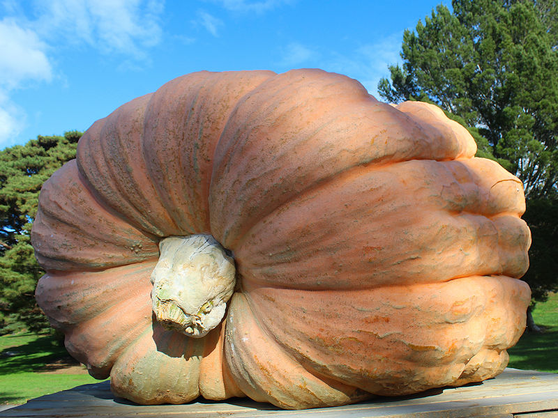
Some fall scenes at the New York Botanical Garden, including a 2,469-lb (1,120 kg) pumpkin grown by Steve Sperry in Rhode Island.
-
The coolest air so far this season will move into the region tonight as the clouds continue to depart. Tomorrow through Tuesday will be chilly late autumnlike days. Some frost will be possible in areas outside New York City and Newark. However, by the middle of the week, temperatures will surge to above and perhaps much above normal levels. During the peak of the warmth, the temperature could reach 70° or above as far north as southern New England. Much cooler air could return to close out October. Nevertheless, October is on track to finish as a warmer than normal month. Since 1950, only a single El Niño event with a monthly ENSO R3.4 anomaly of +1.00°C or above was warmer than normal in New York City during October: 2015 (sample size: 6). If one lowers the ENSO R3.4 anomaly to +0.75°C or above, only two 2/12 (17%) of El Niño cases saw a warmer than normal October in New York City: 1963 and 2015. The ENSO Region 1+2 anomaly was +2.3°C and the Region 3.4 anomaly was +1.5°C for the week centered around October 11. For the past six weeks, the ENSO Region 1+2 anomaly has averaged +2.67°C and the ENSO Region 3.4 anomaly has averaged +1.57°C. El Niño conditions will likely continue to strengthen into the fall with the current East-based event transitioning to a basinwide El Niño for the upcoming winter. The SOI was -23.47 today. The preliminary Arctic Oscillation (AO) was +0.482 today. On October 18 the MJO was in Phase 1 at an amplitude of 0.252 (RMM). The October 17-adjusted amplitude was 0.229 (RMM). Based on sensitivity analysis applied to the latest guidance, there is an implied 79% probability that New York City will have a warmer than normal October (1991-2020 normal). October will likely finish with a mean temperature near 59.1° (1.2° above normal).
-
Periods of rain are likely overnight. Showers will continue into tomorrow across the region before tapering off from west to east. Afterward, the weekend into early next week will likely see its coolest weather so far this fall. Frost will be possible in areas outside New York City and Newark. Temperatures will surge to above and perhaps much above normal levels by the middle of next week. The ENSO Region 1+2 anomaly was +2.3°C and the Region 3.4 anomaly was +1.5°C for the week centered around October 11. For the past six weeks, the ENSO Region 1+2 anomaly has averaged +2.67°C and the ENSO Region 3.4 anomaly has averaged +1.57°C. El Niño conditions will likely continue to strengthen into the fall with the current East-based event transitioning to a basinwide El Niño for the upcoming winter. The SOI was -22.56 today. The preliminary Arctic Oscillation (AO) was +0.723 today. On October 17 the MJO was in Phase 8 at an amplitude of 0.229 (RMM). The October 16-adjusted amplitude was 0.346 (RMM). Based on sensitivity analysis applied to the latest guidance, there is an implied 79% probability that New York City will have a warmer than normal October (1991-2020 normal). October will likely finish with a mean temperature near 59.0° (1.1° above normal).
-
A strong cold front coupled with an offshore storm will bring periods of rain tomorrow into Saturday. A general 0.50" to 1.00" rainfall is likely with some locally higher amounts. Afterward, the weekend into early next week will likely see its coolest weather so far this fall. Frost will be possible in areas outside New York City and Newark. The strong cold shot will then be followed by a potentially impressive warmup. The ENSO Region 1+2 anomaly was +2.3°C and the Region 3.4 anomaly was +1.5°C for the week centered around October 11. For the past six weeks, the ENSO Region 1+2 anomaly has averaged +2.67°C and the ENSO Region 3.4 anomaly has averaged +1.57°C. El Niño conditions will likely continue to strengthen into the fall with the current East-based event transitioning to a basinwide El Niño for the upcoming winter. The SOI was -15.09 today. The preliminary Arctic Oscillation (AO) was +0.403 today. On October 16 the MJO was in Phase 7 at an amplitude of 0.346 (RMM). The October 15-adjusted amplitude was 0.486 (RMM). Based on sensitivity analysis applied to the latest guidance, there is an implied 70% probability that New York City will have a warmer than normal October (1991-2020 normal). October will likely finish with a mean temperature near 58.7° (0.8° above normal).
-
Tomorrow will be fair and noticeably warmer. Much of the region will see the mercury rise into the middle and perhaps upper 60s. The warmest sections could reach 70°. Friday will see clouds increase and showers arrive. A strong cold front will likely bring periods of rain late Friday and during the weekend. Saturday could feature the most rain. Afterward, the weekend into early next week will likely see its coolest weather so far this fall. Frost will be possible in areas outside New York City and Newark. The ENSO Region 1+2 anomaly was +2.3°C and the Region 3.4 anomaly was +1.5°C for the week centered around October 11. For the past six weeks, the ENSO Region 1+2 anomaly has averaged +2.67°C and the ENSO Region 3.4 anomaly has averaged +1.57°C. El Niño conditions will likely continue to strengthen into the fall with the current East-based event transitioning to a basinwide El Niño for the upcoming winter. The SOI was -13.09 today. The preliminary Arctic Oscillation (AO) was -0.208 today. On October 15 the MJO was in Phase 6 at an amplitude of 0.486 (RMM). The October 14-adjusted amplitude was 0.351 (RMM). Based on sensitivity analysis applied to the latest guidance, there is an implied 61% probability that New York City will have a warmer than normal October (1991-2020 normal). October will likely finish with a mean temperature near 58.5° (0.6° above normal).
-
Unseasonably cool conditions will persist through tomorrow. Afterward, readings could reach near normal to somewhat above normal levels. A strong cold front could bring periods of rain during the weekend. Saturday could feature the most rain. The ENSO Region 1+2 anomaly was +2.3°C and the Region 3.4 anomaly was +1.5°C for the week centered around October 11. For the past six weeks, the ENSO Region 1+2 anomaly has averaged +2.67°C and the ENSO Region 3.4 anomaly has averaged +1.57°C. El Niño conditions will likely continue to strengthen into the fall with the current East-based event transitioning to a basinwide El Niño for the upcoming winter. The SOI was -5.55 today. The preliminary Arctic Oscillation (AO) was -1.264 today. Based on sensitivity analysis applied to the latest guidance, there is an implied 63% probability that New York City will have a warmer than normal October (1991-2020 normal). October will likely finish with a mean temperature near 58.6° (0.7° above normal). On October 14 the MJO was in Phase 7 at an amplitude of 0.351 (RMM). The October 13-adjusted amplitude was 0.163 (RMM).
-
Unseasonably cool conditions will persist through at least the middle of the week. Afterward, readings could reach near normal to somewhat above normal levels. A strong cold front could bring periods of rain during the weekend. The ENSO Region 1+2 anomaly was +2.3°C and the Region 3.4 anomaly was +1.5°C for the week centered around October 11. For the past six weeks, the ENSO Region 1+2 anomaly has averaged +2.67°C and the ENSO Region 3.4 anomaly has averaged +1.57°C. El Niño conditions will likely continue to strengthen into the fall with the current East-based event transitioning to a basinwide El Niño for the upcoming winter. The SOI was not available today. The preliminary Arctic Oscillation (AO) was -1.941 today. Based on sensitivity analysis applied to the latest guidance, there is an implied 58% probability that New York City will have a warmer than normal October (1991-2020 normal). October will likely finish with a mean temperature near 58.5° (0.6° above normal). On October 12 the MJO was in Phase 8 at an amplitude of 0.295 (RMM). The October 11-adjusted amplitude was 0.298 (RMM).
-

Occasional Thoughts on Climate Change
donsutherland1 replied to donsutherland1's topic in Climate Change
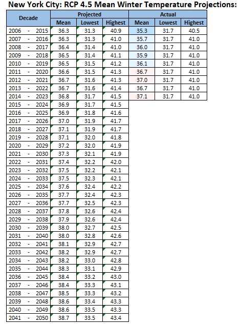
I doubt that NYC will have a frost-free winter through the current century absent some anomalous event that amplifies climate change. There will likely be more winters where the coldest temperature stays in the 20s. I also think that by the mid-2030s, the 30-year average snowfall at Central Park will fall toward or perhaps below 20" based on the rising temperatures and warming oceans. Until recently, New York City's decadal mean winter temperatures had been running below the RCP 4.5 projections. The decadal extremes (coldest and warmest winters for the 10-year period in question) fell within the modeled projections. Recently, the decadal winter averages have been running somewhat warmer than the RCP 4.5 projections. All in all, the climate model projections have been reasonably skillful. -
Unseasonably cool conditions will persist through at least the middle of the week. Afterward, readings could reach near normal to somewhat above normal levels. A strong cold front could bring showers and a period of rain during the weekend. The ENSO Region 1+2 anomaly was +2.8°C and the Region 3.4 anomaly was +1.5°C for the week centered around September 27. For the past six weeks, the ENSO Region 1+2 anomaly has averaged +2.90°C and the ENSO Region 3.4 anomaly has averaged +1.58°C. El Niño conditions will likely continue to strengthen into the fall with the current East-based event transitioning to a basinwide El Niño for the upcoming winter. The SOI was -11.73 today. The preliminary Arctic Oscillation (AO) was -1.865 today. Based on sensitivity analysis applied to the latest guidance, there is an implied 55% probability that New York City will have a warmer than normal October (1991-2020 normal). October will likely finish with a mean temperature near 58.5° (0.6° above normal).
-
Much of the region excepting northern areas remains on track to receive 0.50"-1.50" of rain. The steady rain will continue into the night before tapering off to showers. Tomorrow will likely see some additional showers before clouds break. A gusty chilly wind will prevail throughout the day as another round of unseasonably cool air overspreads the region. The unseasonably cool conditions will likely persist through at least the middle of the week. Afterward, readings could reach near normal to somewhat above normal levels. The ENSO Region 1+2 anomaly was +2.8°C and the Region 3.4 anomaly was +1.5°C for the week centered around September 27. For the past six weeks, the ENSO Region 1+2 anomaly has averaged +2.90°C and the ENSO Region 3.4 anomaly has averaged +1.58°C. El Niño conditions will likely continue to strengthen into the fall with the current East-based event transitioning to a basinwide El Niño for the upcoming winter. The SOI was -4.90 today. The preliminary Arctic Oscillation (AO) was -1.653 today. Based on sensitivity analysis applied to the latest guidance, there is an implied 63% probability that New York City will have a warmer than normal October (1991-2020 normal). October will likely finish with a mean temperature near 58.7° (0.8° above normal).
-

Occasional Thoughts on Climate Change
donsutherland1 replied to donsutherland1's topic in Climate Change
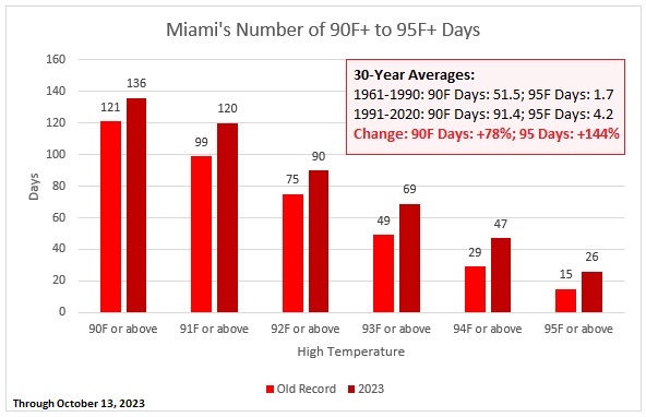
Between 1961-1990 and 1991-2020, Miami has had an increase of 40 90-degree or above days. This year has seen a record number of 90 or above through 95 or above days. Climate change is leading to warming air temperatures and more frequent marine heatwaves, both of which impact Miami. -
A moderate to locally significant rain and wind storm is likely tomorrow into Sunday. A general 0.50"-1.50" rainfall appears likely across much of the area. Northern parts of the region could see much lower amounts. The storm will be followed by another round of unseasonably cool air. Unseasonably cool conditions will likely persist through at least the middle of next week. The ENSO Region 1+2 anomaly was +2.8°C and the Region 3.4 anomaly was +1.5°C for the week centered around September 27. For the past six weeks, the ENSO Region 1+2 anomaly has averaged +2.90°C and the ENSO Region 3.4 anomaly has averaged +1.58°C. El Niño conditions will likely continue to strengthen into the fall with the current East-based event transitioning to a basinwide El Niño for the upcoming winter. The SOI was -4.77 today. The preliminary Arctic Oscillation (AO) was -1.514 today. Based on sensitivity analysis applied to the latest guidance, there is an implied 61% probability that New York City will have a warmer than normal October (1991-2020 normal). October will likely finish with a mean temperature near 58.5° (0.6° above normal).
-

Occasional Thoughts on Climate Change
donsutherland1 replied to donsutherland1's topic in Climate Change
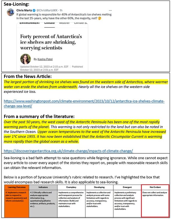
With global temperatures continuing to set records and the impacts of climate change becoming more prominent, there has been increased news coverage. Climate change deniers are trying to attack the stories, often through asking innocent-looking but dishonest and bad faith questions. Below is one example where, even if one had only minimal research skills, one could quickly find the answer to the question that was raised. -
It will turn somewhat cooler tomorrow as clouds increase ahead of the next storm. A moderate to locally significant rain and wind storm is likely Saturday into Sunday. A general 0.50"-1.50" rainfall appears likely across much of the area. Northern parts of the region could see much lower amounts. The storm will be followed by another round of unseasonably cool air. Unseasonably cool conditions will likely persist through at least the middle of next week. The ENSO Region 1+2 anomaly was +2.8°C and the Region 3.4 anomaly was +1.5°C for the week centered around September 27. For the past six weeks, the ENSO Region 1+2 anomaly has averaged +2.90°C and the ENSO Region 3.4 anomaly has averaged +1.58°C. El Niño conditions will likely continue to strengthen into the fall with the current East-based event transitioning to a basinwide El Niño for the upcoming winter. The SOI was -0.58 today. The preliminary Arctic Oscillation (AO) was -0.651 today. Based on sensitivity analysis applied to the latest guidance, there is an implied 58% probability that New York City will have a warmer than normal October (1991-2020 normal). October will likely finish with a mean temperature near 58.4° (0.5° above normal).
-
Readings will again generally reach the upper 60s across the region with warmer spots reaching or exceeding 70°. A moderate or significant rain and wind storm is likely next weekend. The storm will likely be followed by another round of unseasonably cool air. The ENSO Region 1+2 anomaly was +2.8°C and the Region 3.4 anomaly was +1.5°C for the week centered around September 27. For the past six weeks, the ENSO Region 1+2 anomaly has averaged +2.90°C and the ENSO Region 3.4 anomaly has averaged +1.58°C. El Niño conditions will likely continue to strengthen into the fall with the current East-based event transitioning to a basinwide El Niño for the upcoming winter. The SOI was -2.77 today. The preliminary Arctic Oscillation (AO) was -0.015 today. Based on sensitivity analysis applied to the latest guidance, there is an implied 55% probability that New York City will have a warmer than normal October (1991-2020 normal). October will likely finish with a mean temperature near 58.3° (0.4° above normal).
-
Coastal flooding (probably moderate) is a real possibility. We'll have to see how much rain falls and at what rate. Right now, it's looking like a 1"-2" event, which could lead to some flooding, but nowhere near the widespread flooding seen on September 29th.
-
Temperatures rose into the lower and middle 60s across the region today. The warming trend will continue tomorrow. Readings will generally reach the upper 60s across the region with warmer spots reaching or exceeding 70°. Looking farther ahead, the probability of a moderate or significant rain and wind storm next weekend has increased. The storm will likely be followed by another round of unseasonably cool air. The ENSO Region 1+2 anomaly was +2.8°C and the Region 3.4 anomaly was +1.5°C for the week centered around September 27. For the past six weeks, the ENSO Region 1+2 anomaly has averaged +2.90°C and the ENSO Region 3.4 anomaly has averaged +1.58°C. El Niño conditions will likely continue to strengthen into the fall with the current East-based event transitioning to a basinwide El Niño for the upcoming winter. The SOI was -5.87 today. The preliminary Arctic Oscillation (AO) was -0.361 today. Based on sensitivity analysis applied to the latest guidance, there is an implied 55% probability that New York City will have a warmer than normal October (1991-2020 normal). October will likely finish with a mean temperature near 58.3° (0.4° above normal).
-
Temperatures will slowly warm starting tomorrow.Readings will generally reach the lower and middle 60s in the northern Mid-Atlantic region and middle and upper 60s across southern New Jersey southward. Looking farther ahead, the probability of a moderate or significant rain and wind storm next weekend has increased. The storm will likely be followed by another round of unseasonably cool air. The ENSO Region 1+2 anomaly was +2.8°C and the Region 3.4 anomaly was +1.5°C for the week centered around September 27. For the past six weeks, the ENSO Region 1+2 anomaly has averaged +2.90°C and the ENSO Region 3.4 anomaly has averaged +1.58°C. El Niño conditions will likely continue to strengthen into the fall with the current East-based event transitioning to a basinwide El Niño for the upcoming winter. The SOI was -5.87 today. The preliminary Arctic Oscillation (AO) was -0.688 today. Based on sensitivity analysis applied to the latest guidance, there is an implied 55% probability that New York City will have a warmer than normal October (1991-2020 normal). October will likely finish with a mean temperature near 58.4° (0.5° above normal).
-
Tomorrow will be another brisk and cool day. Temperatures will remain below 60° in parts of the region. Temperatures will slowly warm afterward. Looking farther ahead, there is the possibility of a moderate or significant rain and wind storm next weekend followed by another round of unseasonably cool air. The ENSO Region 1+2 anomaly was +2.8°C and the Region 3.4 anomaly was +1.5°C for the week centered around September 27. For the past six weeks, the ENSO Region 1+2 anomaly has averaged +2.90°C and the ENSO Region 3.4 anomaly has averaged +1.58°C. El Niño conditions will likely continue to strengthen into the fall with the current East-based event transitioning to a basinwide El Niño for the upcoming winter. The SOI was -6.45 today. The preliminary Arctic Oscillation (AO) was -0.714 today. Based on sensitivity analysis applied to the latest guidance, there is an implied 56% probability that New York City will have a warmer than normal October (1991-2020 normal). October will likely finish with a mean temperature near 58.5° (0.6° above normal).
-
Following this evening's frontal passage, the coolest air mass so far this season will overspread the region. Tomorrow and Monday will be brisk and cool days. Temperatures will remain below 60° in parts of the region even as sunshine prevails. Temperatures will slowly warm afterward. The ENSO Region 1+2 anomaly was +2.8°C and the Region 3.4 anomaly was +1.5°C for the week centered around September 27. For the past six weeks, the ENSO Region 1+2 anomaly has averaged +2.90°C and the ENSO Region 3.4 anomaly has averaged +1.58°C. El Niño conditions will likely continue to strengthen into the fall with the current East-based event transitioning to a basinwide El Niño for the upcoming winter. The SOI was -5.16 today. The preliminary Arctic Oscillation (AO) was -0.511 today. Based on sensitivity analysis applied to the latest guidance, there is an implied 58% probability that New York City will have a warmer than normal October (1991-2020 normal). October will likely finish with a mean temperature near 58.7° (0.8° above normal).
-
Tomorrow will be rainy and still mild. A general 0.50"-1.50" rainfall with locally higher amounts is likely. The New York City area and nearby suburbs will likely see 1.00"-3.00" of rain. Locally higher amounts in this area could approach or reach 5.00". Following the frontal passage, the coolest air mass so far this season will overspread the region. Monday and Tuesday could see temperatures remain below 60° in parts of the region even as sunshine prevails. Temperatures will slowly warm afterward. The ENSO Region 1+2 anomaly was +2.8°C and the Region 3.4 anomaly was +1.5°C for the week centered around September 27. For the past six weeks, the ENSO Region 1+2 anomaly has averaged +2.90°C and the ENSO Region 3.4 anomaly has averaged +1.58°C. El Niño conditions will likely continue to strengthen into the fall with the current East-based event transitioning to a basinwide El Niño for the upcoming winter. The SOI was -19.21 today. The preliminary Arctic Oscillation (AO) was -0.897 today.
-
Yes. Unfortunately, that's always a risk there. It would not be the first time.
-
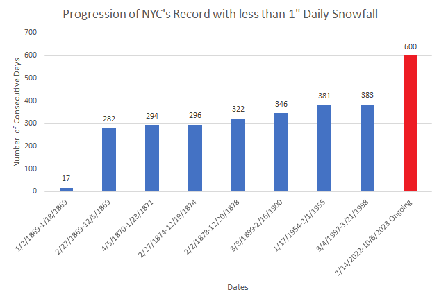
As hopes gradually turn to the coming winter, today will mark New York City's 600th consecutive day on which the City has not seen daily snowfall of 1" or more. No other stretch comes close.


