donsutherland1
-
Posts
24,194 -
Joined
Content Type
Profiles
Blogs
Forums
American Weather
Media Demo
Store
Gallery
Everything posted by donsutherland1
-
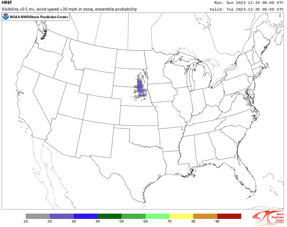
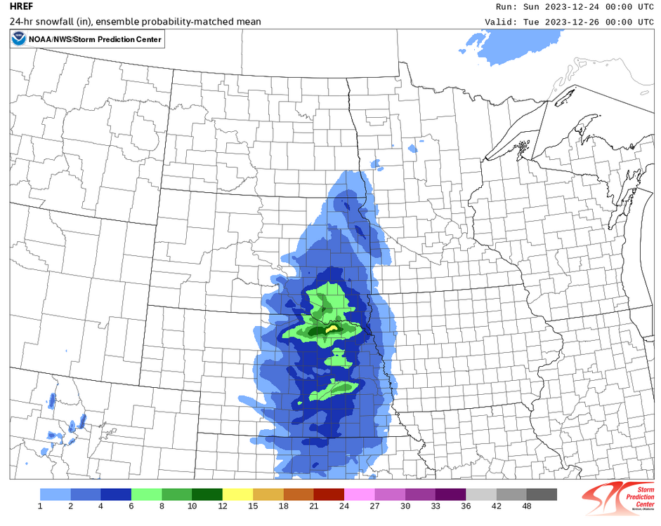
It's already snowing lightly in such areas ad North Platte and Valentine. The latter could see more than a foot of wind-blown snow. A blizzard warning is in effect. Light rain will change to heavy snow in parts of South Dakota where the blizzard is also expected to bring heavy snow.
-
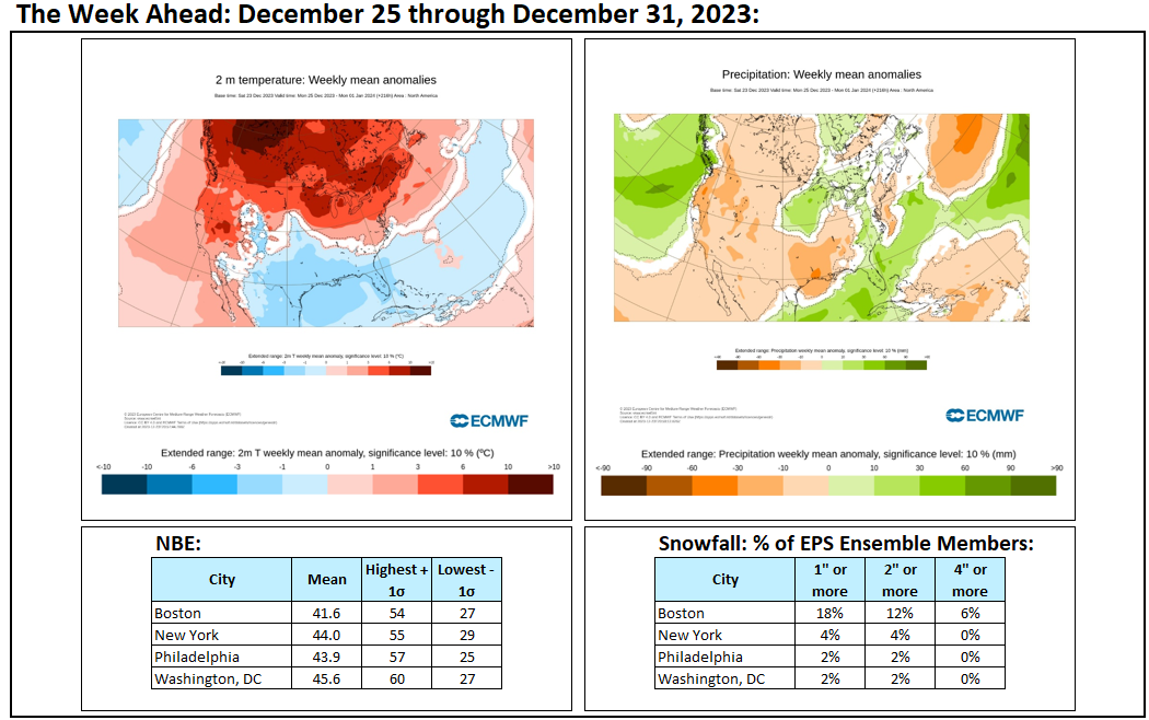
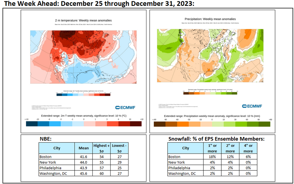
Some week ahead maps and numbers. Cooler air moves in near the end of the month. Prospects for snowfall remain low.
-
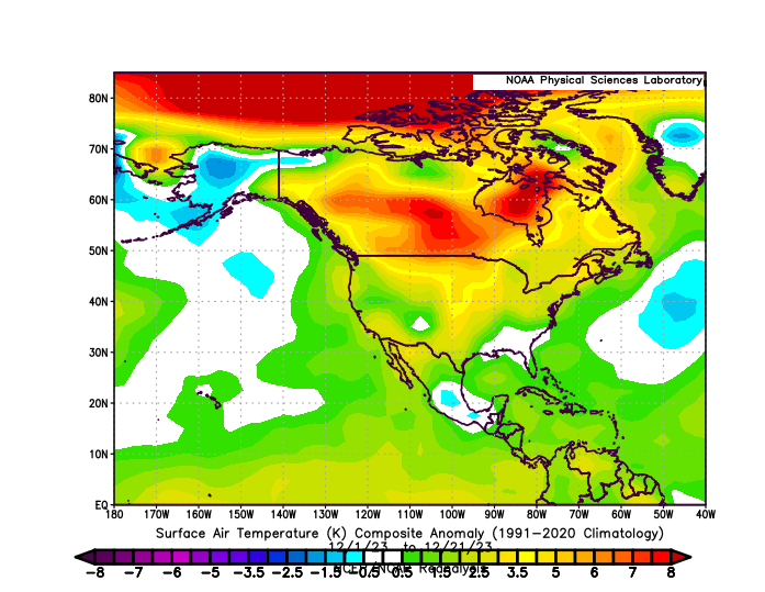
Generally warmer than normal conditions will likely prevail through most of the remainder of December. A transition to a colder pattern will likely commence during the first week of January. Severe cold appears unlikely early in the transition. There remains uncertainty concerning the magnitude and duration of the colder period that could develop. At this time, it appears more likely than not that it will be seasonably cold or somewhat colder than normal with a duration of 1-2 weeks. Initially, the arrival of a colder regime could coincide with a drier one. The ENSO Region 1+2 anomaly was +1.5°C and the Region 3.4 anomaly was +2.0°C for the week centered around December 13. For the past six weeks, the ENSO Region 1+2 anomaly has averaged +1.85°C and the ENSO Region 3.4 anomaly has averaged +1.95°C. A basinwide El Niño event is ongoing. El Niño conditions may strengthen somewhat further this month. The SOI was -36.43 today. The preliminary Arctic Oscillation (AO) was +1.055 today. Strong blocking in the final week of November, as occurred this year, has often been followed by frequent blocking in December and January. Therefore, blocking will likely return in January, if historic experience is representative. The latest GEFS shows a return to Atlantic blocking. On December 21 the MJO was in Phase 7 at an amplitude of 0.722 (RMM). The December 20-adjusted amplitude was 0.834 (RMM). Based on sensitivity analysis applied to the latest guidance, there is an implied near 100% probability that New York City will have a warmer than normal December (1991-2020 normal). December will likely finish with a mean temperature near 43.5° (4.4° above normal). That would make December 2023 the 6th warmest December on record.
-
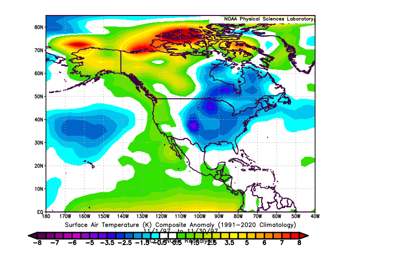
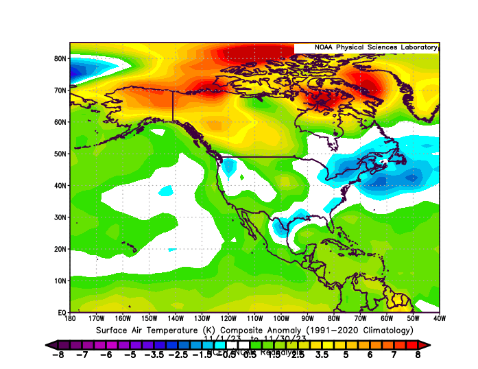
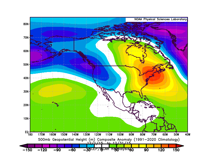
November 1997 Temperature Anomalies: November 2023 Temperature Anomalies: December 2015 500 mg Height Anomalies:
-
As 1997 was referenced, December 2023 blows away December 1997 in terms of the magnitude and expanse of the warmth. They're not even in the same ballpark so to speak. 1997: 2023:
-
In addition, as is the case with many stations with long periods of record, whether 2023 finishes as the warmest year on record or not, 7 of Milwaukee's 10 warmest years will have occurred since 2000. Records there go back to 1871.
-
Parts of the Northeast saw their coldest temperatures so far this season. Low temperatures included: Boston: 21° Bridgeport: 20° Islip: 24° New Haven: 22° New York City: 25° Newark: 25° Philadelphia: 29° Poughkeepsie: 17° White Plains: 20° The cold will now move out of the region after its latest short stay. Afterward, generally warmer than normal conditions will likely prevail through most of the remainder of December. A transition to a colder pattern could commence during the first week of January. Severe cold appears unlikely early in the transition. There remains uncertainty concerning the magnitude and duration of the colder period that could develop. At this time, it appears more likely than not that it will be seasonably cold or somewhat colder than normal with a duration of 1-2 weeks. The ENSO Region 1+2 anomaly was +1.5°C and the Region 3.4 anomaly was +2.0°C for the week centered around December 13. For the past six weeks, the ENSO Region 1+2 anomaly has averaged +1.85°C and the ENSO Region 3.4 anomaly has averaged +1.95°C. A basinwide El Niño event is ongoing. El Niño conditions may strengthen somewhat further this month. The SOI was -30.67 today. The preliminary Arctic Oscillation (AO) was +1.941 today. Strong blocking in the final week of November, as occurred this year, has often been followed by frequent blocking in December and January. Therefore, blocking will likely return in January, if historic experience is representative. The latest GEFS shows a return to Atlantic blocking. On December 20 the MJO was in Phase 7 at an amplitude of 0.834 (RMM). The December 19-adjusted amplitude was 0.818 (RMM). Based on sensitivity analysis applied to the latest guidance, there is an implied near 100% probability that New York City will have a warmer than normal December (1991-2020 normal). December will likely finish with a mean temperature near 43.5° (4.4° above normal). That would make December 2023 the 6th warmest December on record.
-
White Christmas vs. 50° Christmas: New York City:
-
Thanks for the kind words. I threw it together this morning after reading some of the commentary here.
-
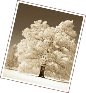
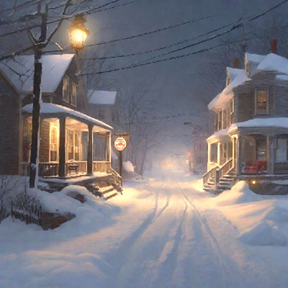
The Snow Returns The calendar marched into January. There was no snow in Snowtown. To the local residents, it seemed that their village had taken its name from a time that was now in danger of being lost forever. In coming years, only the oldest residents would be able to say that they had actually experienced a snowfall. Once they departed, they would take their precious winter memories with them. Snowtown found itself mired in the grips of a dreadful multi-year snow drought. Even the GFS computer model had abandoned its long-range fantasy snowstorms. Those digital depictions had continually raised hopes. Yet, over and over again, those hopes were dashed on the jagged rocks of reality, as the promised winter storms never materialized. It appeared that the GFS model had finally surrendered to reality. Everyone in the village had taken notice. At the local college, students taking the Philosophy 101 course used the absence of snow to argue their understanding of eternity. The local shops that still sold a range of winter goods were placed on an “endangered business list” that the local Chamber of Commerce had compiled to bring attention to the village’s plight. Snowtown's winter charm was disappearing just as the snows had vanished into a receding past. The only places snow could be found were on aging photographs, digital images, and the paintings that hung in the local art gallery. The gap that divided imagery from real experience was an unbridgeable one. The two century-old Maple Tree that dated to the village’s establishment still stood. One day, its rings would tell amazing stories to any scientist who examined them. It had weathered droughts, violent thunderstorms, pounding hail, torrents of rain, howling blizzards, and two hurricanes. During summers, the shade from its thick leaves provided a measure of refuge from the wrath of an increasingly vengeful sun that ruled summers that now stretched from late May into October. The night was mild. Large, heavy raindrops began to fall. Within minutes, rivulets ran along the curbsides. Water ponded in opportunistic spots. The wind freshened. It would be another wild, mild, and wet night. By midnight, most of the village’s residents had fallen asleep as the soaking rain beat against their windows. A few college students labored into the night: writing, cutting, pasting, and re-writing. The tedious sound of the falling rain added to their exhaustion. Caffeinated drinks had lost their power to stave off sleep. Ella, a tall platinum blond international student from Paris, tried to push on. Although fluent in English, her thoughts increasingly began to flow in French. The paper required English. Fatigue had broken down her fluency. Now, she had to work to translate her French-language thoughts into English-language text. “I need another cappuccino,” she thought to herself. She walked quickly into the small kitchen in the 19th century home that had been converted into dorms for the college students. Through muscle memory, she quickly whipped up a giant mug of steaming cappuccino. She placed the ceramic mug, which featured Claude Monet’s “Snow at Argenteuil,” next to her laptop. She glanced at the screen. She read through the last paragraph she had written. She prepared to write with renewed vigor. And then there was darkness. Sometime late at night, the unusually intense storm tapped into a distant air mass that was just cold enough to support snow. In almost a flash, the driving rain gave way to wet snow. The swirling snowflakes fell thick and fast, shrouding the quaint village as if it were cloaked in fog. The wet snow plastered everything it encountered. Snowtown’s charming residential streets were quickly covered in a thickening blanket of white. Ella suddenly awakened. The sound of the furious raindrops that had been lashing her dorm’s windows had fallen silent. Not completely silent. It seemed as if gusts of wind rose time and again to hurl bursts of countless tiny pellets against the glass that separated Ella from the raging elements outside. The wind had taken on a different, less mournful, tone, too. Ella opened her eyes. The room seemed brighter. Her faithful lamp that illuminated her small desk shone on. Her laptop’s screen saver glowed from the light of the Monet that had supplanted her Word document. But the lighting really was different. “What time is it…?” she asked herself. Ella realized that despite her frantic last-second effort to arm herself with caffeine to work through the night, she had succumbed to sleep. The gusts of wind flung the heavily falling snow against the windows. Now awake, Ella sought to resume her writing. She hit “Enter” and the screen saver was gone in an instant. Ella’s document was again on the screen. Twelve-point Times New Roman text had replaced the Impressionist masterpiece. Now she would write. But she did not start. Her growing curiosity about what was happening outside had become an unstoppable force that drew her away from her laptop to the window. She had to see whatever it was that pulled her away from her assignment. She opened the Venetian blinds. The old, dreary wet world was gone. A new magical one had come into existence. Having lived through the brutal heat of Parisian summers marked by intense heatwaves with temperatures of 40°C (104°F or above) and having never seen snow before, she hurriedly put on her overcoat, scarf and boots. Concluding that there would be no class in the coming day, she stepped outside to explore the new world that was before her. Note: All images were generated using multiple AI platforms. The first image was also processed in Sepia. No text was generated by AI.

-
Another shot of cold air is arriving to end the week. However, the cold will be far from severe. Tomorrow will be blustery and cold with highs ranging from the upper 30s in New York City to around 40° in Philadelphia. No Arctic air is likely through the remainder of December. A transition to a colder pattern could commence during the first week of January. Severe cold appears unlikely early in the transition. There is uncertainty concerning the timing and duration of the colder period that could develop. The ENSO Region 1+2 anomaly was +1.5°C and the Region 3.4 anomaly was +2.0°C for the week centered around December 13. For the past six weeks, the ENSO Region 1+2 anomaly has averaged +1.85°C and the ENSO Region 3.4 anomaly has averaged +1.95°C. A basinwide El Niño event is ongoing. El Niño conditions may strengthen somewhat further this month. The SOI was -14.32 today. The preliminary Arctic Oscillation (AO) was +3.209 today. Strong blocking in the final week of November, as occurred this year, has often been followed by frequent blocking in December and January. Therefore, blocking will likely return in January, if historic experience is representative. On December 19 the MJO was in Phase 7 at an amplitude of 0.818 (RMM). The December 18-adjusted amplitude was 0.988 (RMM). Based on sensitivity analysis applied to the latest guidance, there is an implied 98% probability that New York City will have a warmer than normal December (1991-2020 normal). December will likely finish with a mean temperature near 43.2° (4.1° above normal). That would make December 2023 the 8th warmest December on record.
-
Climate change won't end winter in the New York City area anytime soon. Winters will continue to grow shorter and warmer overall, as has been occurring. As winter temperatures continue to rise, NYC will cross a threshold where the impact of the rising warmth more than offsets the increase in precipitation. At that time, seasonal snowfall will decline, as it has in such cities as Richmond and Washington. Based on the climate model forecasts for mean winter temperatures and snowfall data for the Mid-Atlantic region that has reached those forecast levels, New York City's annual snowfall (30-year average) could fall to around 20" by the mid-2030s. There will still be some high snowfall winters and big snowstorms. At the same time, I wouldn't be surprised if the record low figure of 2.3" from winter 2022-23 is tested again at some point. At present, it is too soon to know whether the recent drop off in snowfall indicates that the transition toward a generally less snowy regime has started. I suspect that stochastic variability and climate change are both involved. If the transition is underway, it would be in its early stages. Central and especially northern New England might see further increases in seasonal snowfall into the 2030s, as the benefits of added moisture continue to outweigh the impact of warming there.
-
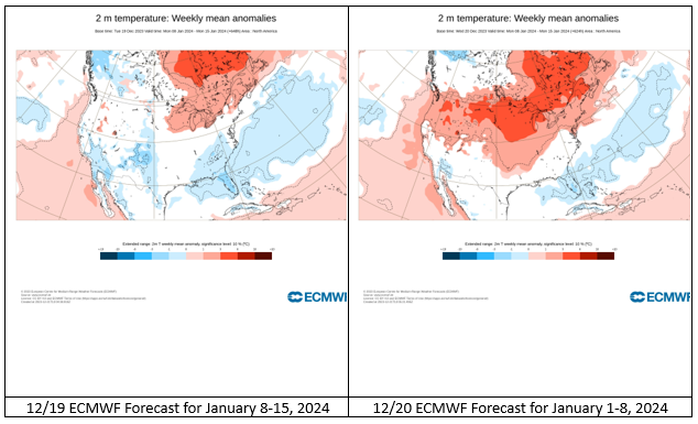
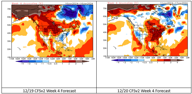
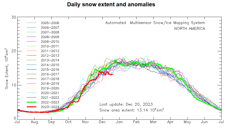
The guidance has stepped back somewhat. Severe cold did not seem likely through at least the first week of January and perhaps beyond. The cold was also focused largely on the Southeast. The second week of January had shown more widespread cold, but nothing notable. ECMWF Forecasts for January 8-15, 2024: CFSv2 Week 4 Forecasts: For the Northeast, the first week of January might well see readings closer to normal than they have been. That regime could continue through the second week of the month. If cross-polar flow can develop, the cold would be more widespread and significant. The record low North American snow cover will play a role in constraining the magnitude of the cold, so I don't expect to see any single-digit readings through the first half of December unless strong cross-polar flow can develop, which appears unlikely right now. Of course, the guidance at that range is low skill, but the persistent ongoing basinwide strong El Niño, PDO-, and limited North American snow cover all argue for taking a more conservative (milder) path when it comes to expectations about the magnitude, duration, and extent of the cold. Additional risks are posed by the possibility that a PNA- could develop early in January, which would heighten the risk of any available cold air dumping into the West. Finally, the AO reached +3.000 yesterday. Total snowfall through January 10th for cases when the AO reached +3 or above during December 15-25 is generally less than 3" with numerous cases of an inch or less. The highest amount was 6.4" during winter 2013-2014. The character of that emerging winter was dramatically different from that of 2023-24. December 8-9, 2013 saw 8.6" of snow fall in Philadelphia and 12.0" fall in Wilmington, DE. The last week of December saw much of Canada covered by significant cold. Extraordinary warmth is likely in much of Canada during the close of December. In parts of Canada, December monthly record warm temperatures are possible. Unless things begin to change e.g., real signs for the commencement of cross-polar flow begin to emerge, my thinking is: 1. The pattern will change during the first week of January. A period of 1-2 (maybe 3 weeks) of generally near normal temperatures will develop for the northern Mid-Atlantic and New England areas. Farther south will be somewhat colder than normal. The Northeast could see short stretches of below normal readings during this period, but severe cold seems unlikely. 2. There will be a few (maybe 1-3) opportunities for measurable snow in the New York City area, but snowfalls will likely be on the lighter side (<2"). Beyond that, the extent and impact of the forecast weakening of the stratospheric polar vortex will help influence the evolution of events.
-
Colder air currently covers the region. Another shot of cold air will arrive to end the week. However, the cold will be far from severe. No Arctic air appears likely through the remainder of December. A transition to a colder pattern could commence during the first week of January. Severe cold appears unlikely early in the transition. There is uncertainty concerning the timing and duration of the colder period that could develop. The ENSO Region 1+2 anomaly was +1.5°C and the Region 3.4 anomaly was +2.0°C for the week centered around December 13. For the past six weeks, the ENSO Region 1+2 anomaly has averaged +1.85°C and the ENSO Region 3.4 anomaly has averaged +1.95°C. A basinwide El Niño event is ongoing. El Niño conditions may strengthen somewhat further this month. The SOI was -2.28 today. The preliminary Arctic Oscillation (AO) was +3.043 today. Strong blocking in the final week of November, as occurred this year, has often been followed by frequent blocking in December and January. Therefore, blocking will likely return in January, if historic experience is representative. On December 18 the MJO was in Phase 7 at an amplitude of 0.988 (RMM). The December 17-adjusted amplitude was 1.014 (RMM). Based on sensitivity analysis applied to the latest guidance, there is an implied 98% probability that New York City will have a warmer than normal December (1991-2020 normal). December will likely finish with a mean temperature near 43.0° (3.9° above normal).
-
That’s only through December 19th. 2022-23 ultimately finished second overall.
-
Occasional Thoughts on Climate Change
donsutherland1 replied to donsutherland1's topic in Climate Change
I will read it. Thanks for sharing it. -
Occasional Thoughts on Climate Change
donsutherland1 replied to donsutherland1's topic in Climate Change
Unfortunately, I believe a large share of political leaders tend to pay disproportionate attention to older voters who vote in high numbers and fund campaigns. This may help create policy inertia, as there is some research showing greater commitment to the status quo as one ages. This perspective can create a formidable barrier to reform, as reform risks the support of a still-coveted voting demographic. Can anyone imagine today's collection of aged leaders boldly proclaiming that humans would set foot on the Moon in a decade as President Kennedy had done in 1961? Far more likely, they would lazily rationalize that there are more worthy and less costly endeavors. The same applies to boldly moving away from the current unsustainable and destructive energy model. They maintain a minimalist approach and will not set any binding phase-out targets for fossil fuels. Policy making rooted in the hope for a future miracle or magical assumptions about new technology that will alleviate the burden of responsibility to make decisive choices is leadership failure. Because climate change will play out over a long timeframe that extends far beyond the human life span, policy making is mired deeply in a bias for short-term interests. Heatwaves, drought, and intense rainfall events are largely overlooked even when they occur without prior precedent. Even more ominously, the lessons of those early warning signs of catastrophe are missed altogether. Back in April 2003, Harvard Business Review wrote of the reality where companies routinely miss early warning of future crises. HBR explained, "Despite thoughtful managers and robust planning processes, even the best run companies are frequently caught unaware by disastrous events—events that should have been anticipated and prepared for." During 2018-2021, a long-running marine heatwave wiped out 10 billion snow crabs in the Bering Sea. In September 2021, the rains from former Hurricane Ida deluged the New York City area with more than 3" of rain in an hour, causing widespread flooding. In 2022, Europe experienced an estimated 60,000 heat-related deaths. These are hints of much worse that could lie ahead, as climate change's extremes increase in non-linear fashion to the rise in temperatures. What if a marine heatwave wipes out an appreciable portion of zooplankton, which rapidly ripples up the food chain to krill, squid, tuna, etc.? What if a storm similar to Ida hits NYC or some other major metropolitan area and then largely stalls like Hurricane Harvey did in 2017? What if a super heatwave (as occurred in the Pacific Northwest in 2021 or parts of the southern U.S. in 2023) descends on a high population region and persists for a month or longer? All of these events occurred with warming that is 1.2°C-1.3°C above the pre-industrial temperature average. The world remains locked on a trajectory toward 2.8°C-2.9°C warming by the end of the current century. Such events could have enormous impacts on food (possible famine), health, and/or mortality. Such scenarios would not have come "out of the blue" but would be examples of the "predictable surprises" laid out by HBR. The severity of each of these events could still be mitigated were political leaders to possess the measure of political courage and foresight necessary to address climate change. -
For winters 1988-89 through 1999-00: Mean snowfall: 22.4" Mean snowfall excluding 1995-96: 17.6" Mean snowfall excluding 1993-94 and 1995-96: 13.9"
-
Occasional Thoughts on Climate Change
donsutherland1 replied to donsutherland1's topic in Climate Change
Effective leadership would also be a remedy. In 1989, the Montreal Protocol was ratified. In 1990 during COP 2, it was agreed that CFCs would be completely phased out by 1997. IMO, the world's leaders were able to act decisively, because they had genuine experience with having to make tough decisions during the Cold War era. Today's leaders have not faced the degree of challenge that was inherent in the Cold War and they haven't developed the capacity to make decisive choices. The U.S. can't even bring itself to declare a climate emergency and, at the same time, is scaling up its oil and gas productive capacity. This is an unfortunate situation, because today's youth and tomorrow's generations will have to live with the consequences of the bad or weak choices being made today. -
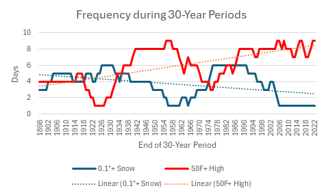
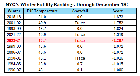
Winter futility rankings through December 19th: Winter 2023-2024 is yet another warm, late-starting winter: Mean seasonal snowfall for the 9 winters listed with 2023-24: 17.2" Most seasonal snowfall: 32.8", 2015-16 Least seasonal snowfall: 3.5", 2001-02
-
It is virtually certain that 2023 will become NYC’s warmest year on record. My guess is that it will finish at 57.8 or 57.9.
-
Occasional Thoughts on Climate Change
donsutherland1 replied to donsutherland1's topic in Climate Change
It may take some time to really supplant fossil fuel energy. There's a tremendous amount of inertia built into the political and economic systems. Moreover, the fossil fuel industry--the beneficiary of enormous subsidies and which generates large profits--has sufficient resources to skew policy making. The fight for a sustainable climate is far from over. Unfortunately, the UN Secretary-General can't set the decisionmaking agenda for the COP conferences. Unless fossil fuel interests are barred from the conferences, they will be in a position to thwart meaningful progress. -
Colder air now covers the region. Another shot of cold air will arrive to end the week. However, the cold will be far from severe. No Arctic air appears likely through the remainder of December. A transition to a colder pattern could commence during the first week of January. Severe cold appears unlikely early in the transition. The ENSO Region 1+2 anomaly was +1.5°C and the Region 3.4 anomaly was +2.0°C for the week centered around December 13. For the past six weeks, the ENSO Region 1+2 anomaly has averaged +1.85°C and the ENSO Region 3.4 anomaly has averaged +1.95°C. A basinwide El Niño event is ongoing. El Niño conditions may strengthen somewhat further this month. The SOI was +0.47 today. The preliminary Arctic Oscillation (AO) was +2.292 today. Strong blocking in the final week of November, as occurred this year, has often been followed by frequent blocking in December and January. On December 17 the MJO was in Phase 7 at an amplitude of 1.661 (RMM). The December 16-adjusted amplitude was 1.737 (RMM). Based on sensitivity analysis applied to the latest guidance, there is an implied 97% probability that New York City will have a warmer than normal December (1991-2020 normal). December will likely finish with a mean temperature near 42.8° (3.7° above normal).
-
The powerful storm responsible for bringing record daily rainfall amounts to the Southeast and parts of the Middle Atlantic region, including a possible 24-hour state rainfall record in South Carolina, brought heavy rain to the region overnight into this morning. Gumboro, DE (5.74"); Butler, NJ (5.53"); and, Stockley, DE (5.52") were among locations receiving rainfall of 5" or more today. A number of 19th century daily rainfall records, including Concord's and Central Park's records from 1876, were broken. Regional rainfall amounts included: Albany: 2.13" (old record: 1.52", 1887) Atlantic City: 2.27" (old record: 1.10", 1986) Bangor: 2.19" (old record: 0.68", 1975) Binghamton: 2.06" (old record: 0.90", 1990) Boston: 1.64" (old record: 1.44", 1951) Bridgeport: 1.87" (old record: 1.14", 1951) Burlington: 2.02" (old record: 0.85", 1954) Concord: 2.28" (old record: 1.60", 1876) Hartford: 2.17" (old record: 1.95", 1986) Islip: 1.65" (old record: 1.41", 2012) Manchester: 2.46" (old record: 1.29", 1954) New Haven: 1.77" (old record: 1.24", 1961) New York City-Central Park: 2.21" (old record: 1.30", 1876) New York City-JFK Airport: 1.47" (old record: 1.32", 1986) New York City-LaGuardia Airport: 2.13" (old record: 1.29", 1961) Newark: 2.75" (old record: 1.22", 1951) Philadelphia: 2.19" (old record: 1.72", 1977) Poughkeepsie: 2.23" (old record: 1.52", 1887) Providence: 2.42" (old record: 1.46", 1954) Scranton: 2.16" (old record: 0.93", 1961) Trenton: 2.17" (old record: 1.80", 1887) White Plains: 2.64" (old record: 1.51", 2000) Worcester: 2.82" (old record: 1.79", 1954) In the warm sector of the storm, parts of the region also experienced daily record high temperatures. Daily records included: Bangor: 61° (old record: 53°, 1954 and 2000) Boston: 63° (old record: 61°, 1915 and tied in 1928 and 1990) Caribou: 57° (old record: 54°, 2000) Concord: 62° (old record: 59°, 1928) Hartford: 64° (old record: 58°, 1954) Islip: 61° (old record: 59°, 1984) Manchester: 64° (old record: 54°, 1954) New Haven: 62° (old record: 54°, 1966 and 2006) New York City-LaGuardia Airport: 63° (old record: 62°, 2006) Newark: 64° (tied record set in 1937) Portland: 59° (old record: 53°, 1996) Poughkeepsie: 64° (old record: 55°, 1954) Westfield, MA: 63° (old record: 54°, 1928) Westhampton: 62° (old record: 56°. 2012 and 2015) White Plains: 63° (old record: 61°, 2006) Worcester: 61° (old record: 57°, 1928) Behind the storm, it will turn colder, but not severely cold. Tomorrow could see variably cloudy conditions with some passing snow flurries or snow showers, generally well north and west of New York City and Newark. No Arctic air appears likely through the remainder of December. A transition to a colder pattern could commence during the first week of January. Severe cold appears unlikely early in the transition. The ENSO Region 1+2 anomaly was +1.5°C and the Region 3.4 anomaly was +2.0°C for the week centered around December 13. For the past six weeks, the ENSO Region 1+2 anomaly has averaged +1.85°C and the ENSO Region 3.4 anomaly has averaged +1.95°C. A basinwide El Niño event is ongoing. El Niño conditions may strengthen somewhat further this month. The SOI was +7.42 today. The preliminary Arctic Oscillation (AO) was +2.835 today. Strong blocking in the final week of November, as occurred this year, has often been followed by frequent blocking in December and January. On December 16 the MJO was in Phase 7 at an amplitude of 1.737 (RMM). The December-adjusted amplitude was 1.617 (RMM). Based on sensitivity analysis applied to the latest guidance, there is an implied 95% probability that New York City will have a warmer than normal December (1991-2020 normal). December will likely finish with a mean temperature near 42.5° (3.4° above normal).
-
Moderate-High Impact Storm Noon Sun Dec 17, 2023 - 4PM Mon Dec 18. Flooding rain I95 corridor northwestward, coastal tidal flooding, brief periods of damaging 50 MPH+ wind gusts LI/CT Monday, ends as a little wet snow interior elevations Tue morning.
donsutherland1 replied to wdrag's topic in New York City Metro
Earlier this morning, drier air punched into the storm's circulation bringing breaks in the clouds and a short period of sunshine.The wind had largely died down.

- 489 replies
-
- 7
-

-
- flooding rains
- coastal flooding
- (and 4 more)