donsutherland1
-
Posts
24,194 -
Joined
Content Type
Profiles
Blogs
Forums
American Weather
Media Demo
Store
Gallery
Everything posted by donsutherland1
-
Moderate-High Impact Storm Noon Sun Dec 17, 2023 - 4PM Mon Dec 18. Flooding rain I95 corridor northwestward, coastal tidal flooding, brief periods of damaging 50 MPH+ wind gusts LI/CT Monday, ends as a little wet snow interior elevations Tue morning.
donsutherland1 replied to wdrag's topic in New York City Metro
McLellanville 1W, SC picked up 16.32" of rain yesterday. If validated, it would break the 24-hour record of 14.80" from Myrtle Beach during Hurricane Floyd on September 16, 1999 for the all-time 24-hour record.- 489 replies
-
- 6
-

-

-
- flooding rains
- coastal flooding
- (and 4 more)
-
Moderate-High Impact Storm Noon Sun Dec 17, 2023 - 4PM Mon Dec 18. Flooding rain I95 corridor northwestward, coastal tidal flooding, brief periods of damaging 50 MPH+ wind gusts LI/CT Monday, ends as a little wet snow interior elevations Tue morning.
donsutherland1 replied to wdrag's topic in New York City Metro
Daily record highs have already fallen at Islip, New Haven, New York City-LaGuardia Airport, Poughkeepsie, and White Plains. The record high was tied in Newark.- 489 replies
-
- 1
-
-
- flooding rains
- coastal flooding
- (and 4 more)
-
Warmth was more widespread and somewhat more intense than what had been shown on the weekly guidance.

-
Moderate-High Impact Storm Noon Sun Dec 17, 2023 - 4PM Mon Dec 18. Flooding rain I95 corridor northwestward, coastal tidal flooding, brief periods of damaging 50 MPH+ wind gusts LI/CT Monday, ends as a little wet snow interior elevations Tue morning.
donsutherland1 replied to wdrag's topic in New York City Metro
24-hour HREF map:
-
Moderate-High Impact Storm Noon Sun Dec 17, 2023 - 4PM Mon Dec 18. Flooding rain I95 corridor northwestward, coastal tidal flooding, brief periods of damaging 50 MPH+ wind gusts LI/CT Monday, ends as a little wet snow interior elevations Tue morning.
donsutherland1 replied to wdrag's topic in New York City Metro
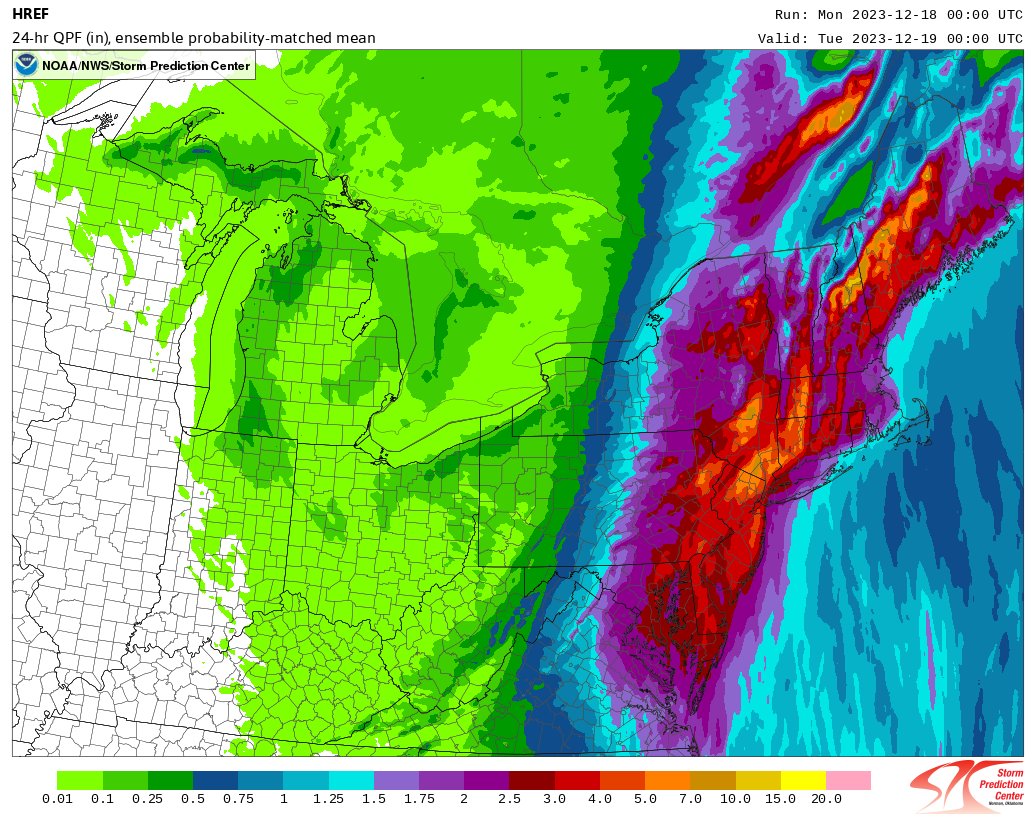
As of 10 pm, rain was falling heavily in Atlantic City, Baltimore, Philadelphia, Sterling, and Washington, DC. The heavy rain will continue to advance northward. The New York City area will likely see its heaviest rain during a period that runs from midnight to about 8 am. The area of heaviest rain still appears likely to occur north and west of Newark and New York City. Strong winds will lash the coastline and coastal flooding is likely at times of high tide. The latest HREF guidance is below: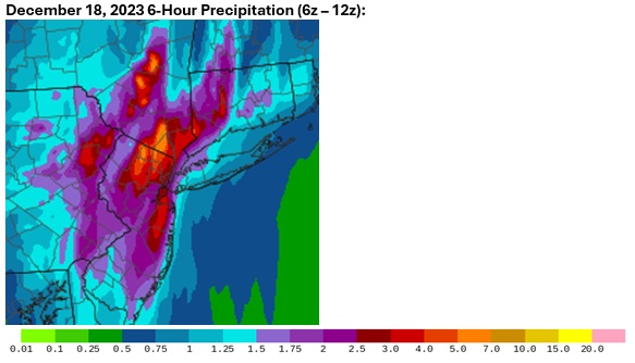
-
Daily rainfall at McClellanville (7 NE), SC is now 13.30".
-
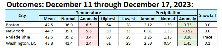
Parts of the Southeast saw record daily rainfall. Daily records through 5 pm included: Charleston: 2.57" (old record: 0.66", 1975) Charleston (Downtown): 4.36" (old record: 1.18", 1923) ***New December monthly record*** Columbia, SC: 2.20" (old record: 1.16", 1888) Fayetteville: 2.30" (old record: 1.68", 1970) Greensboro: 1.64" (old record: 1.52", 1930) Lumberton, NC: 2.58" (old record: 1.90", 1970) Myrtle Beach: 3.69" (old record: 0.50", 1994) Raleigh: 2.05" (old record: 1.35", 1890) Savannah: 3.16" (old record: 1.96", 1880) Wilmington, NC: 2.83" (old record: 0.88", 1887) McClellanville (7 NE), SC was deluged by 12.21" of rain. That broke the all-time daily precipitation record of 10.37" that was set on September 5, 2019. The highest December daily amount for South Carolina in the xmACIS database is 8.10" that fell at Pawleys Island (2.6N) on December 24, 2019. Heavy rain from that storm has reached Norfolk. It will continue to advance northward this evening. Overall, the powerful storm will bring a general 2"-4" rainfall to a wide swath of the region by the time the rain ends tomorrow. Locally higher amounts could reach or exceed 5". Strong winds gusting up to 50 mph could create tree and power line damage. Coastal flooding, especially tomorrow, is likely. Behind the storm, it will turn colder, but not severely cold. Tuesday could see variably cloudy conditions with some passing snow flurries or snow showers, generally well north and west of New York City and Newark. No Arctic air appears likely through the remainder of December. A transition to a colder pattern could commence during the first week of January. The ENSO Region 1+2 anomaly was +1.3°C and the Region 3.4 anomaly was +1.9°C for the week centered around December 6. For the past six weeks, the ENSO Region 1+2 anomaly has averaged +1.97°C and the ENSO Region 3.4 anomaly has averaged +1.92°C. A basinwide El Niño event is ongoing. El Niño conditions will may strengthen somewhat further this month. The SOI was +7.42 today. The preliminary Arctic Oscillation (AO) was +2.835 today. Strong blocking in the final week of November, as occurred this year, has often been followed by frequent blocking in December and January. Based on sensitivity analysis applied to the latest guidance, there is an implied 93% probability that New York City will have a warmer than normal December (1991-2020 normal). December will likely finish with a mean temperature near 42.4° (3.3° above normal).
-
Moderate-High Impact Storm Noon Sun Dec 17, 2023 - 4PM Mon Dec 18. Flooding rain I95 corridor northwestward, coastal tidal flooding, brief periods of damaging 50 MPH+ wind gusts LI/CT Monday, ends as a little wet snow interior elevations Tue morning.
donsutherland1 replied to wdrag's topic in New York City Metro
The 12/17 12z HREF: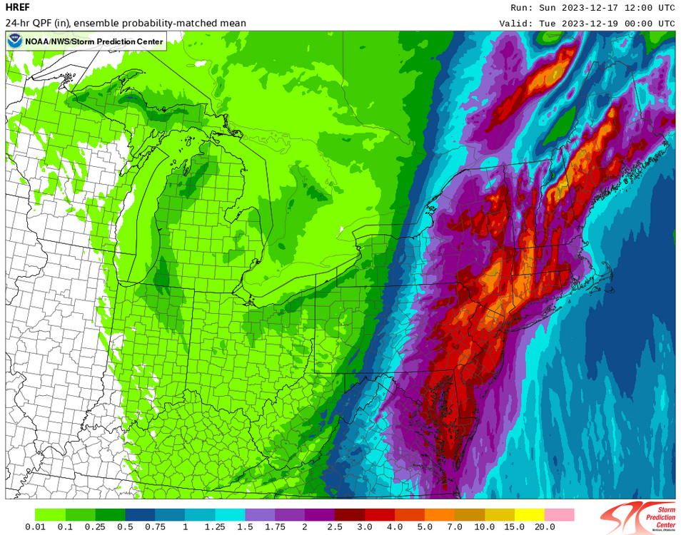
- 489 replies
-
- 1
-
-
- flooding rains
- coastal flooding
- (and 4 more)
-
Prompt updated:
-
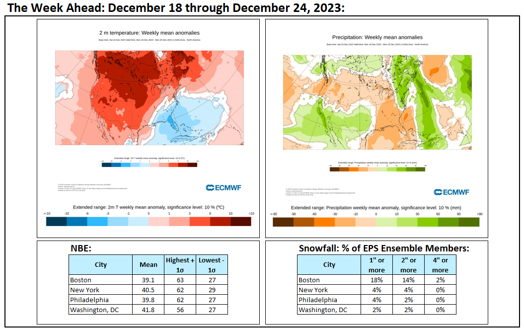
Week ahead numbers:

-
Under mainly sunny skies, the temperature again rose into the 50s across the region. The mild weather will continue through the weekend. Meanwhile Florida was picking up moderate to heavy rain. Fort Lauderdale had picked up 1.12" as of 5 pm, which surpassed the daily record of 1.00" from 1958. West Palm Beach had 1.47", which was approaching the daily record of 1.70" that had been set in 1892. Parts of the Southeast could see December record 2-3 day rainfall totals. That storm will bring a general 2"-4" rainfall to a wide swath of the region tomorrow into Monday. Locally higher amounts could reach or exceed 5". Strong winds gusting up to 50 mphs could create tree and power line damage. Coastal flooding, especially on Monday, is likely. No Arctic air appears likely through the remainder of December. A transition to a colder pattern could commence during the first week of January. The ENSO Region 1+2 anomaly was +1.3°C and the Region 3.4 anomaly was +1.9°C for the week centered around December 6. For the past six weeks, the ENSO Region 1+2 anomaly has averaged +1.97°C and the ENSO Region 3.4 anomaly has averaged +1.92°C. A basinwide El Niño event is ongoing. El Niño conditions will may strengthen somewhat further this month. The SOI was +11.99 today. The preliminary Arctic Oscillation (AO) was +1.874 today. Strong blocking in the final week of November, as occurred this year, has often been followed by frequent blocking in December and January. Based on sensitivity analysis applied to the latest guidance, there is an implied 90% probability that New York City will have a warmer than normal December (1991-2020 normal). December will likely finish with a mean temperature near 42.1° (3.0° above normal).
-
I agree regarding genuine Arctic air.
-
I agree with you about the thaw and February.
-
Winters 1972-73 (15.17") and 1973-74 (15.27") were actually much wetter than normal (December-February precipitation). Storm tracks played a major role in that snow drought.
-
I expect that the breakdown in Atlantic blocking is temporary. It should redevelop in January. The broader pattern should also be transitioning during the first week of January.
-
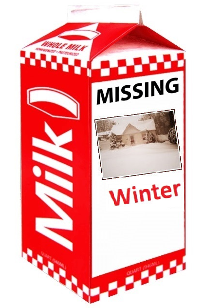
The milk carton was a template. The photo was taken in Patchogue during the January 2022 storm.
-
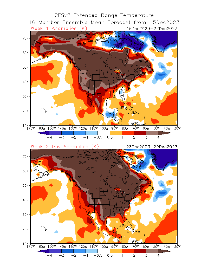
If the CFSv2 is right, patience remains in order. Genuine winter weather for the NYC and Philadelphia areas appears unlikely through most of the month. Periodically, the GFS and even ECMWF have flirted with the idea of some snowfall next week, but have since backed off. CFSv2: Status of Winter:

-
Unfortunately, it does.
-
I'm looking forward to breaking this drought.
-
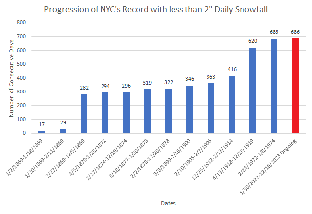
New York City has unlocked another sad winter record, as its unprecedented streak without 1" or more snowfall reaches 671 days today. New York City will record its 686th consecutive day without 2" or more daily snowfall. Both streaks look likely to continue through at least the next week, if not longer.
-
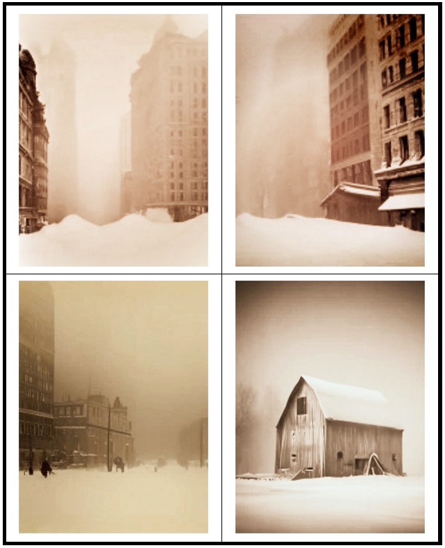
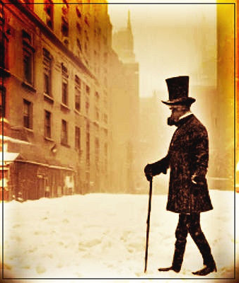
While New York City has reached 670 consecutive days without having seen daily snowfall of an inch or more, I asked AI to generate some images of snowstorms. The images were then processed to create a 19th century feel. There were some issues creating the images on the AI side, but all in all, they worked out reasonably well.

-
Under brilliant sunshine, the temperature soared into the middle and upper 50s across the region. The mild weather will continue through the weekend. A significant rainstorm is likely Sunday evening into Monday. A general 1"-3" of rain is possible with locally higher amounts. Strong winds and coastal flooding are likely. Tree and power line damage could occur. No Arctic air appears likely through the remainder of December. A transition to a colder pattern could commence during the first week of January. The ENSO Region 1+2 anomaly was +1.3°C and the Region 3.4 anomaly was +1.9°C for the week centered around December 6. For the past six weeks, the ENSO Region 1+2 anomaly has averaged +1.97°C and the ENSO Region 3.4 anomaly has averaged +1.92°C. A basinwide El Niño event is ongoing. El Niño conditions will may strengthen somewhat further this month. The SOI was -7.68 today. The preliminary Arctic Oscillation (AO) was +1.152 today. Strong blocking in the final week of November, as occurred this year, has often been followed by frequent blocking in December and January. Based on sensitivity analysis applied to the latest guidance, there is an implied 84% probability that New York City will have a warmer than normal December (1991-2020 normal). December will likely finish with a mean temperature near 41.8° (2.7° above normal).
-
Under bright sunshine, the warmth is again overperforming. Readings are running about 1.5 sigma or more above the modeled highs. High temperatures through 2 pm include: Bridgeport: 55° Islip: 55° New York City: 56° Newark: 59° White Plains: 56°
-
Occasional Thoughts on Climate Change
donsutherland1 replied to donsutherland1's topic in Climate Change
I agree. I welcome the changes that are taking place albeit at a much smaller scale than what is needed to secure the 1.5°C goal. My concern is that fossil fuels remain largely stable as a share of overall energy production (around 80% worldwide). COP 28 did nothing to change that trajectory. Indeed, just days after the Conference, its President Sultan Al Jaber reaffirmed his company's plans to invest in expanding its oil and gas production capacity stating that the world will still need the "lowest-carbon barrels at the lowest cost." That oil and gas are not low carbon sources of energy was not mentioned. This is how he interprets the COP 28 outcome. As he was its President, his interpretation is arguably the definitive one. Other fossil fuel companies and producers almost certainly will see things the way he does. -
It will turn milder tomorrow. Temperatures will top out in the balmy 50s across most of the region. The mild weather will continue through the weekend. A significant rainstorm followed by a continuation of above normal temperatures is likely Sunday evening into Monday. A general 1"-3" of rain is possible. Strong winds and coastal flooding are likely. No Arctic air appears likely through the remainder of December. If anything, the warm risks for the closing 7-10 days of the month have increased. A transition to a colder pattern could commence during the first week of January. The ENSO Region 1+2 anomaly was +1.3°C and the Region 3.4 anomaly was +1.9°C for the week centered around December 6. For the past six weeks, the ENSO Region 1+2 anomaly has averaged +1.97°C and the ENSO Region 3.4 anomaly has averaged +1.92°C. A basinwide El Niño event is ongoing. El Niño conditions will may strengthen somewhat further this month. The SOI was -4.36 on December 13. The preliminary Arctic Oscillation (AO) was +1.548 today. Strong blocking in the final week of November, as occurred this year, has often been followed by frequent blocking in December and January. Based on sensitivity analysis applied to the latest guidance, there is an implied 80% probability that New York City will have a warmer than normal December (1991-2020 normal). December will likely finish with a mean temperature near 41.6° (2.5° above normal).