donsutherland1
-
Posts
24,194 -
Joined
Content Type
Profiles
Blogs
Forums
American Weather
Media Demo
Store
Gallery
Everything posted by donsutherland1
-
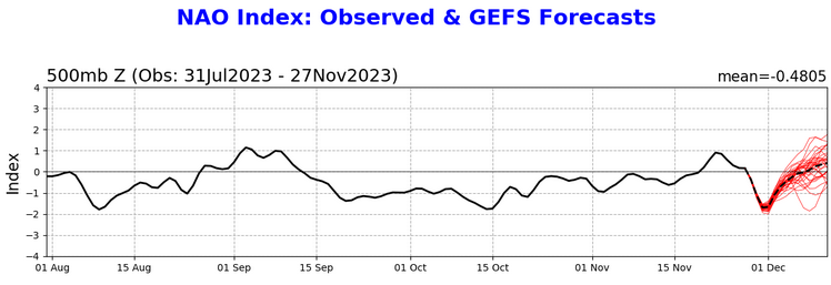
Latest NAO forecast shows the NAO going positive in the extended range. The AO remains negative. Were both to go positive, that would favor an even warmer outcome than is currently forecast.
-
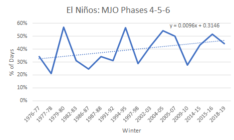
It should be noted that even as there is large variability in the percentage of days during which the MJO is in Phases 4-6 during El Niño events, the percentage has been trending higher during the winter months. The trend is based on the 16 El Niños for which daily MJO data is available.
-
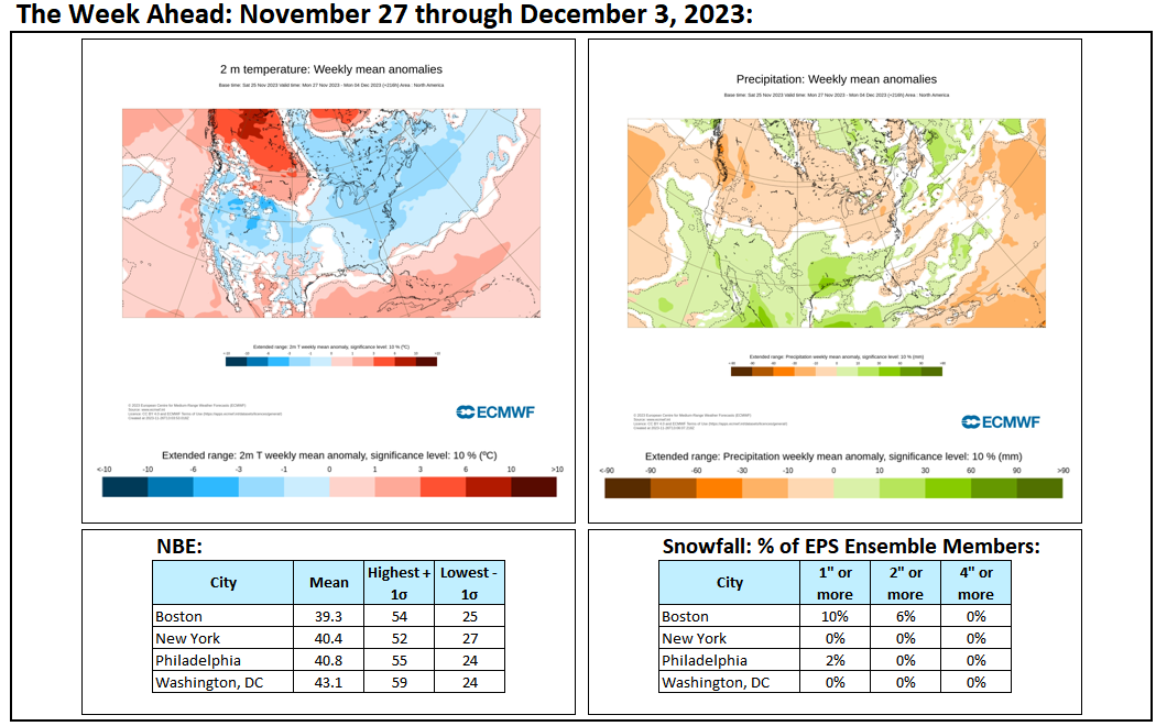
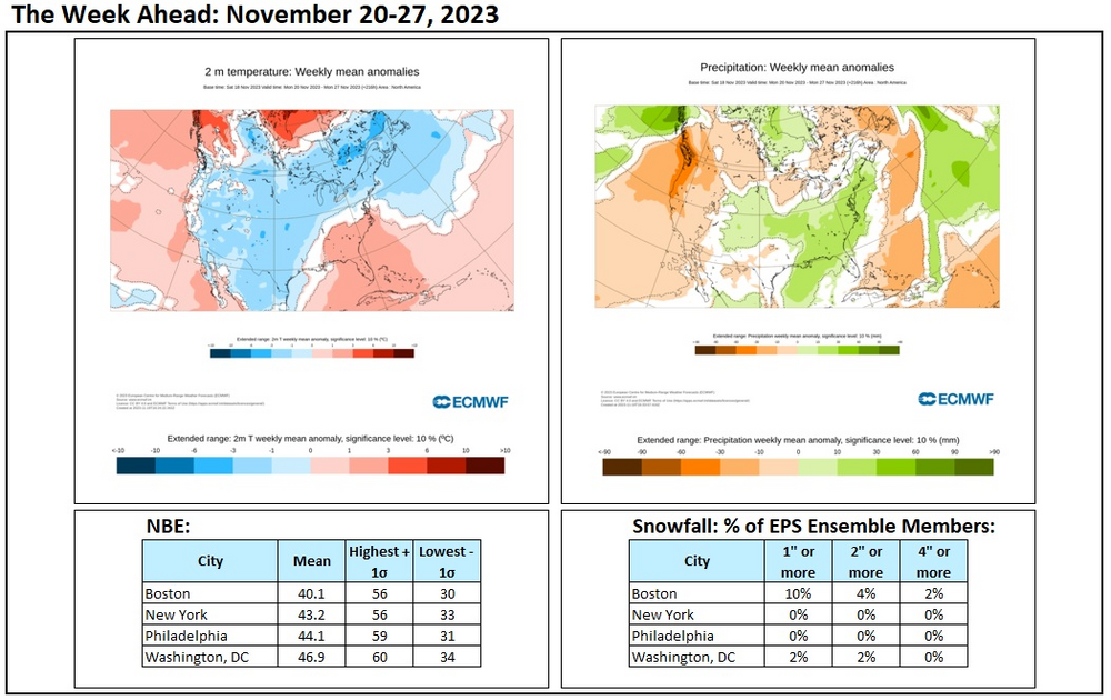
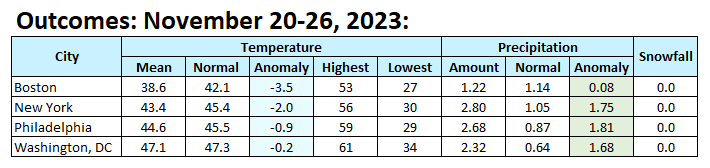
Final Outcomes:
-
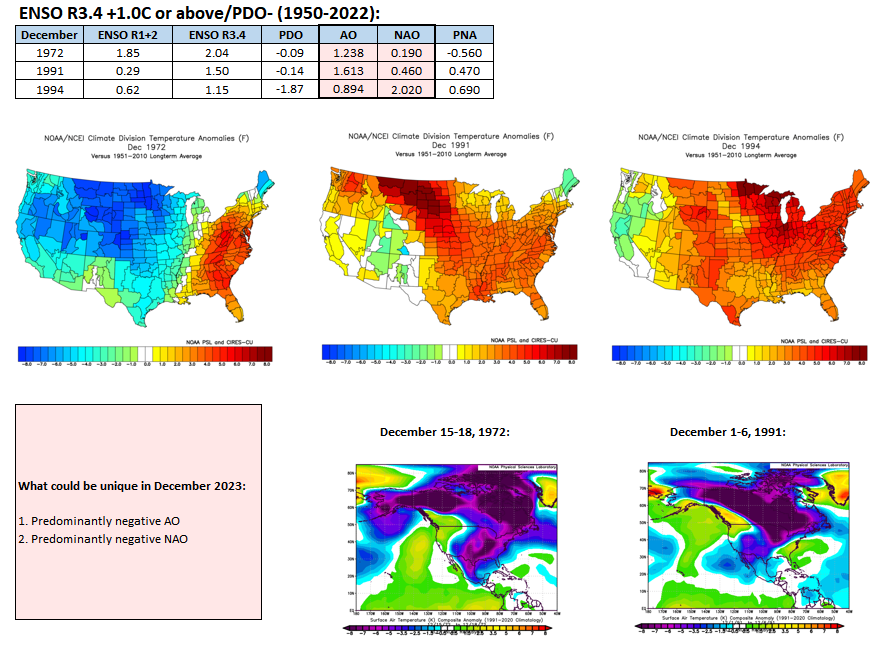
It’s not an analog but an illustration of how few winters there have been with an ENSO Region 3.4 anomaly of 1C or above and a negative PDO. This December could be unique as there should be more blocking than during any of those three cases.
-
Those weren’t great winters up here. Parts of the South from Georgia into the Carolinas had a historic snowstorm during February 1973.
-
It’s developing. We’ll need it to be sustained. If the Pacific can then improve, we should be in business for potential wintry outcomes. That’s still beyond the skillful range of the guidance. Hopefully, things will evolve to allow us to break the ongoing snow drought.
-
"Hot" off the CPC press:
-
E PA/NJ/DE Fall 2023 OBS/Discussion Thread
donsutherland1 replied to Rtd208's topic in Philadelphia Region
It is, but El Niño winters are often backloaded to January and February. -
E PA/NJ/DE Fall 2023 OBS/Discussion Thread
donsutherland1 replied to Rtd208's topic in Philadelphia Region
Hopefully, January and February will break the snow drought in a big way. -
A developing storm will bring rain to the region tonight into early tomorrow. Most areas should see 0.50"-1.00" of rain. Areas on eastern Long Island into eastern New England could see higher amounts. In the wake of the storm, Monday will turn partly cloudy, breezy, and mild. However, colder air will overspread the region and temperatures could fall during the afternoon hours. Tuesday and Wednesday will be partly sunny but unseasonably cold. Flurries are possible, especially on Tuesday. A moderating trend should commence during the middle of the week. The ENSO Region 1+2 anomaly was +2.0°C and the Region 3.4 anomaly was +1.9°C for the week centered around November 15. For the past six weeks, the ENSO Region 1+2 anomaly has averaged +2.27°C and the ENSO Region 3.4 anomaly has averaged +1.70°C. El Niño conditions will likely continue to strengthen into the early winter as the current East-based event completes its evolution into a basinwide El Niño. Should the ENSO Region 1+2 and 3.4 anomalies remain at or above +1.00°C in December, which is likely, and should the PDO remain negative, there is a single past case (1950-2022) with similar ENSO/PDO conditions: December 1972. The SOI was +10.18 today. The preliminary Arctic Oscillation (AO) was -0.121 today. On November 24 the MJO was in Phase 2 at an amplitude of 1.141 (RMM). The November 23-adjusted amplitude was 1.140 (RMM). Based on sensitivity analysis applied to the latest guidance, there is an implied near 100% probability that New York City will have a cooler than normal November (1991-2020 normal). November will likely finish with a mean temperature near 46.0° (1.9° below normal). That would be New York City's coldest November since November 2019.
-
E PA/NJ/DE Fall 2023 OBS/Discussion Thread
donsutherland1 replied to Rtd208's topic in Philadelphia Region
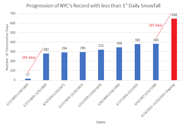
Recently, Philadelphia set a new record for its longest streak without daily snowfall of 1" or more. Elsewhere existing records include: Allentown: 368 days Atlantic City: 715 days Baltimore: 672 days New York City: 651 days (ongoing) Richmond: 725 days Trenton: 664 days Washington, DC: 788 days Wilmington, DE: 756 days Note: All numbers are through today, as no snowfall is expected.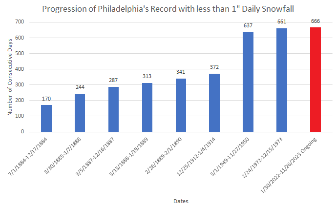
-
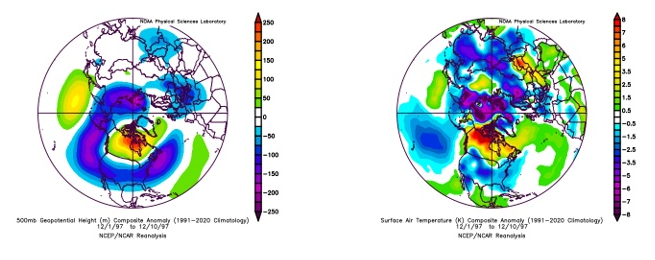
December 2023 appears poised to move into little charted, if not uncharted territory for an El Niño event with a Region 3.4 anomaly of +1° or above and a negative PDO. None of the three cases since 1950 featured a predominantly negative Arctic Oscillation (AO) or North Atlantic Oscillation (NAO). The possibility of such an outcome exists this time around, possibly due to ongoing marine heatwaves that have distorted the effects of the ongoing El Niño to date. With the AAM forecast to go positive during the first week of December, there is also the risk of the development of a more typical El Niño hemispheric pattern. During that time, the MJO could approach or reach the warmer Maritime Continent phases. Some lessons from the past might be applicable, especially when one considers the periods of blocking that occurred during those past three cases (December 15-18, 1972 and December 1-6, 1991): 1. Cold could be nearby or present when Atlantic blocking is ongoing. As the climate has warmed since these cases, especially 1972, areas of cold could be less expansive and less impressive than they were during the December 1972 and December 1991 blocking episodes. Overall, December 2023 could be colder relative to normal than the 1972, 1991, and 1994 cases, but not necessarily colder than normal, as blocking should be present for a longer period of time than during those cases. 2. Monthly snowfall will likely be linked to the presence of the blocking. All of December 1991's 0.7" snowfall in New York City occurred when the AO and NAO were negative. Total snowfall for December 1972 and 1994 came to a trace. Given historic experience with the three El Niño cases above, keeping in mind the tiny sample size, there remains at least some risk that the blocking forecast for early December could break down for the second half of the month.
-
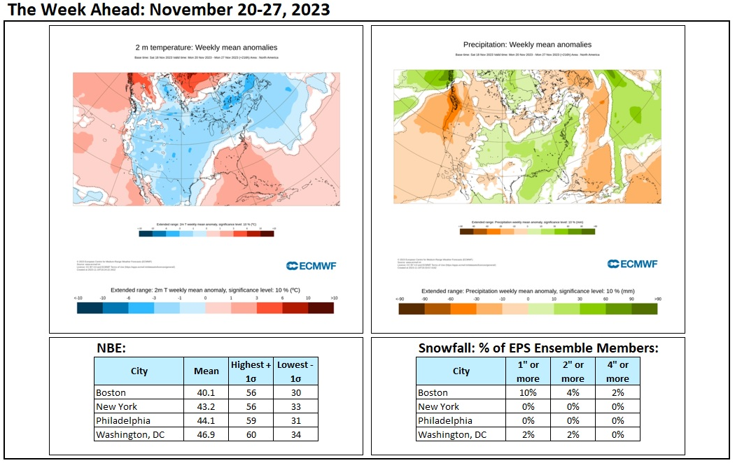
The latest numbers for the week ahead:

-
Clouds will increase tomorrow and it will turn milder. A system will bring rain to the region tomorrow night into Monday. Most areas should see 0.25"-0.75" of rain. The remainder of November will should be generally colder than normal with a reinforcing shot of cold air for Tuesday into Wednesday. Some flurries are possible on Tuesday or Wednesday. However, no Arctic blasts appear likely. Conditions should also be mainly dry through the remainder of the month. The ENSO Region 1+2 anomaly was +2.0°C and the Region 3.4 anomaly was +1.9°C for the week centered around November 15. For the past six weeks, the ENSO Region 1+2 anomaly has averaged +2.27°C and the ENSO Region 3.4 anomaly has averaged +1.70°C. El Niño conditions will likely continue to strengthen into the early winter as the current East-based event completes its evolution into a basinwide El Niño. Should the ENSO Region 1+2 and 3.4 anomalies remain at or above +1.00°C in December, which is likely, and should the PDO remain negative, there is a single past case (1950-2022) with similar ENSO/PDO conditions: December 1972. The SOI was not available today. The preliminary Arctic Oscillation (AO) was -0.114 today. On November 23 the MJO was in Phase 1 at an amplitude of 1.140 (RMM). The November 22-adjusted amplitude was 1.470 (RMM). Based on sensitivity analysis applied to the latest guidance, there is an implied 99% probability that New York City will have a cooler than normal November (1991-2020 normal). November will likely finish with a mean temperature near 46.0° (1.9° below normal). That would be New York City's coldest November since November 2019.
-
Ongoing marine heatwaves are distorting the atmospheric response.
-
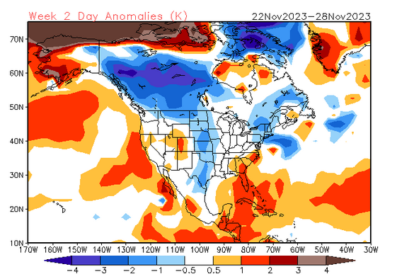
This is possibly the unspoken fear: As long as the formative block strengthens rather than fades after the first week of December or avoids sinking southwestward to the Hudson Bay/James Bay area, there should be some opportunities even if Arctic air doesn't get involved. A breakdown in blocking would result in the development of a milder pattern, especially as the AAM is forecast to go positive starting late in the first week of December. The latter would allow the block to protrude into the Northeast, as has happened at times in recent years, which could suppress the subtropical jet stream. At this point, things are looking more promising than last winter. But beyond two weeks, model skill is low so speculative outcomes beyond mid-December are essentially guesses right now.
-
Tonight will be fair and unseasonably cold. New York City will very likely see its first freeze of the season. After a brisk but dry day tomorrow, clouds will increase on Sunday and it will turn somewhat milder. A system will bring rain to the region Sunday night into Monday. Most areas should see 0.50"-1.00" of rain. Philadelphia will likely see lesser amounts. The remainder of November will should be generally colder than normal with a reinforcing shot of cold air near the end of the month. However, no Arctic blasts appear likely. Conditions should also be mainly dry through the remainder of the month. The ENSO Region 1+2 anomaly was +2.0°C and the Region 3.4 anomaly was +1.9°C for the week centered around November 15. For the past six weeks, the ENSO Region 1+2 anomaly has averaged +2.27°C and the ENSO Region 3.4 anomaly has averaged +1.70°C. El Niño conditions will likely continue to strengthen into the early winter as the current East-based event completes its evolution into a basinwide El Niño. Should the ENSO Region 1+2 and 3.4 anomalies remain at or above +1.00°C in December, which is likely, and should the PDO remain negative, there is a single past case (1950-2022) with similar ENSO/PDO conditions: December 1972. The SOI was not available today. The preliminary Arctic Oscillation (AO) was -0.019 today. On November 22 the MJO was in Phase 1 at an amplitude of 1.570 (RMM). The November 21-adjusted amplitude was 1.470 (RMM). Based on sensitivity analysis applied to the latest guidance, there is an implied 96% probability that New York City will have a cooler than normal November (1991-2020 normal). November will likely finish with a mean temperature near 46.0° (1.9° below normal). That would be New York City's coldest November since November 2019.
-
Google + AI = Superior Weather forecasting
donsutherland1 replied to J.Mike's topic in Weather Forecasting and Discussion
Graphcast (which uses the ECMWF initialization) has had some successes beyond 500 mb verification scores so far. It did miss for tomorrow in the medium range, as it initially had a moderate to significant precipitation event for the northern Mid-Atlantic region. Unlike with the previous claims of a “superior” Panasonic model (never open for verification), Graphcast seems to be the real deal so far. -
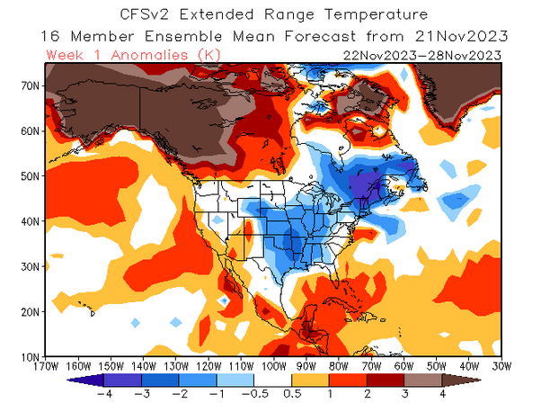
The final CFSv2 forecast for the November 22-28 period:
-
The coldest air mass so far this season will overspread the region tomorrow. Saturday morning will likely see New York City experience its first freeze of the season. The remainder of November will likely be generally cooler than normal with a reinforcing shot of cold air near the end of the month. However, no Arctic blasts appear likely. Conditions should also be mainly dry through the remainder of the month with the only rainfall likely Sunday night or Monday morning. The ENSO Region 1+2 anomaly was +2.0°C and the Region 3.4 anomaly was +1.9°C for the week centered around November 15. For the past six weeks, the ENSO Region 1+2 anomaly has averaged +2.27°C and the ENSO Region 3.4 anomaly has averaged +1.70°C. El Niño conditions will likely continue to strengthen into the early winter as the current East-based event completes its evolution into a basinwide El Niño. Currently, 2023 is in uncharted territory as far as the ENSO Region 3.4 anomaly and PDO are concerned. The October ENSO Region 3.4 anomaly was +1.59°C while the PDO was -1.71. Prior to 2023, the lowest October PDO when the ENSO Region 3.4 anomaly was +1.00°C or above was -0.36 in 1965. Should the ENSO Region 1+2 and 3.4 anomalies remain at or above +1.00°C in December, which is likely, and should the PDO remain negative, there is a single past case (1950-2022) with similar conditions: December 1972. The SOI was -16.48 today. The preliminary Arctic Oscillation (AO) was +0.690 today. On November 21 the MJO was in Phase 1 at an amplitude of 1.570 (RMM). The November 20-adjusted amplitude was 1.578 (RMM). Based on sensitivity analysis applied to the latest guidance, there is an implied 95% probability that New York City will have a cooler than normal November (1991-2020 normal). November will likely finish with a mean temperature near 45.9° (2.0° below normal). That would be New York City's coldest November since November 2019.
-
Today will be the 648th consecutive day on which New York City has not seen an inch or more of daily snowfall. That exceeds the previous record by 265 days, which ties the record for the largest margin by which this sorry record has been broken.
-
I am glad you missed it. A few years ago, the population here was out of control. A period of bow hunting reduced the population to manageable levels.
-
The heavy rain ended early this morning. Two-day rainfall totals included: Bridgeport: 2.61" Islip: 1.62" New York City: 2.52" Newark: 2.24" Philadelphia: 1.81" Daily rainfall records were set today at: Bridgeport: 2.37" (old record: 1.52", 1991) Islip: 1.25" (old record: 0.99", 1985) New York City-LaGuardia Airport: 1.78" (old record: 1.48", 1952) Thanksgiving Day will be blustery and cooler, but not harsh. Highs should reach the upper 40s and lower 50s. An even colder air mass should arrive late in the week. Friday night or Saturday morning will likely see New York City experience its first freeze of the season. The remainder of November will likely be generally cooler than normal. However, no Arctic blasts appear likely. Conditions should also be mainly dry. The ENSO Region 1+2 anomaly was +2.0°C and the Region 3.4 anomaly was +1.9°C for the week centered around November 15. For the past six weeks, the ENSO Region 1+2 anomaly has averaged +2.27°C and the ENSO Region 3.4 anomaly has averaged +1.70°C. El Niño conditions will likely continue to strengthen into the early winter as the current East-based event completes its evolution into a basinwide El Niño. Currently, 2023 is in uncharted territory as far as the ENSO Region 3.4 anomaly and PDO are concerned. The October ENSO Region 3.4 anomaly was +1.59°C while the PDO was -1.71. Prior to 2023, the lowest October PDO when the ENSO Region 3.4 anomaly was +1.00°C or above was -0.36 in 1965. Should the ENSO Region 1+2 and 3.4 anomalies remain at or above +1.00°C in December, which is likely, and should the PDO remain negative, there is a single past case (1950-2022) with similar conditions: December 1972. The SOI was -18.07 today. The preliminary Arctic Oscillation (AO) was +1.030 today. On November 20 the MJO was in Phase 1 at an amplitude of 1.578 (RMM). The November 19-adjusted amplitude was 1.564 (RMM). Based on sensitivity analysis applied to the latest guidance, there is an implied 93% probability that New York City will have a cooler than normal November (1991-2020 normal). November will likely finish with a mean temperature near 46.0° (2.0° below normal). That would be New York City's coldest November since November 2019.
-
Following last night’s heavy rainfall, deer were out and about.


-
It remains to be seen how things will ultimately evolve. With the AAM forecast to go positive during or after the first week of December, a more typical El Niño pattern could try to develop.