donsutherland1
-
Posts
24,194 -
Joined
Content Type
Profiles
Blogs
Forums
American Weather
Media Demo
Store
Gallery
Everything posted by donsutherland1
-
Yes. Unfortunately, that's always a risk there. It would not be the first time.
-
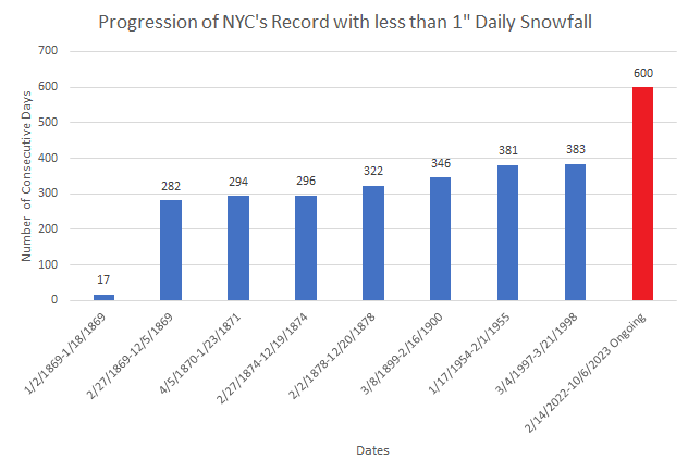
As hopes gradually turn to the coming winter, today will mark New York City's 600th consecutive day on which the City has not seen daily snowfall of 1" or more. No other stretch comes close.
-
Warmer than normal weather will continue for much of the first week of October. Temperatures could reach or exceed 80° tomorrow. The warmth will extend well north into Canada where Montreal and Quebec City could challenge or break their October records. Colder air will push into the East during the upcoming weekend. The cold air will be preceded by showers or periods of rain from a storm. The possibility exists for a moderate or significant rainfall. The ENSO Region 1+2 anomaly was +2.8°C and the Region 3.4 anomaly was +1.5°C for the week centered around September 27. For the past six weeks, the ENSO Region 1+2 anomaly has averaged +2.90°C and the ENSO Region 3.4 anomaly has averaged +1.58°C. El Niño conditions will likely continue to strengthen into the fall with the current East-based event transitioning to a basinwide El Niño for the upcoming winter. The SOI was -0.65 today. The preliminary Arctic Oscillation (AO) was +1.046 today.
-
Warmer than normal weather will continue for much of the first week of October. Temperatures could reach 80° or above tomorrow and Wednesday. The warmth will extend well north into Canada where Montreal and Quebec City could challenge or break their October records. Earlier today, Thunder Bay reached an October record high of 86°. Colder air will push into the East during the upcoming weekend. The cold air will be preceded by showers or periods of rain from a storm. The possibility exists for a moderate or significant rainfall. The ENSO Region 1+2 anomaly was +2.8°C and the Region 3.4 anomaly was +1.5°C for the week centered around September 27. For the past six weeks, the ENSO Region 1+2 anomaly has averaged +2.90°C and the ENSO Region 3.4 anomaly has averaged +1.58°C. El Niño conditions will likely continue to strengthen into the fall with the current East-based event transitioning to a basinwide El Niño for the upcoming winter. The SOI was -3.48 today. The preliminary Arctic Oscillation (AO) was +0.877 today.
-
Boosted by a flood of sunshine, temperatures ranged from the middle 70s to even lower 80s across the region. In the Plains States and Great Lakes Region much more intense heat prevailed. October monthly records included: Eau Claire, WI: 89° Marshall, MN: 94° Minneapolis: 92° Saint Cloud, MN: 91° Sioux Falls, SD: 95° Spencer, IA: 95° Across parts of France, Spain, and Italy hundreds of monthly records were beaten, some by 10°. Spain also saw a 101° (38.2°C) temperature, which set a new national October record. Warmer than normal weather will continue for much of the first week of October. Temperatures could reach 80° or above on several days next week. Colder air could push into the East during the upcoming weekend. The cold air will be preceded by showers or periods of rain. The ENSO Region 1+2 anomaly was +2.8°C and the Region 3.4 anomaly was +1.7°C for the week centered around September 20. For the past six weeks, the ENSO Region 1+2 anomaly has averaged +2.98°C and the ENSO Region 3.4 anomaly has averaged +1.55°C. El Niño conditions will likely continue to strengthen into the fall with the current East-based event transitioning to a basinwide El Niño for the upcoming winter. The SOI was -5.03 today. The preliminary Arctic Oscillation (AO) was +0.354 today.
-
October 2023 temperature forecast contest
donsutherland1 replied to Roger Smith's topic in Weather Forecasting and Discussion
DCA _ NYC _ BOS __ ORD _ ATL _ IAH ___ DEN _ PHX _ SEA 1.1 1.2 1.6 2.9 0.9 1.5 2.7 1.7 1.9 -
September is concluding with a mean temperature of 69.4° in New York City. That is 0.2° above normal. A spell of warmer than normal weather lies ahead for much of the first week of October. Temperatures could reach 80° or above on several days next week. However, this warmth will be minor compared to the record-breaking heat that will start October in parts of the Plains States and Midwest. Today, Macomb, IL reached 98°. The previous latest-season 90° reading occurred on September 4, 1906. Moreover, that tied the September monthly record. There remain indications that colder air could push into the East near the start of the second week of October or just afterward, possibly preceded by yet another storm. The ENSO Region 1+2 anomaly was +2.8°C and the Region 3.4 anomaly was +1.7°C for the week centered around September 20. For the past six weeks, the ENSO Region 1+2 anomaly has averaged +2.98°C and the ENSO Region 3.4 anomaly has averaged +1.55°C. El Niño conditions will likely continue to strengthen into the fall with the current East-based event transitioning to a basinwide El Niño for the upcoming winter. The SOI was -7.19 today. The preliminary Arctic Oscillation (AO) was +0.219 today.
-
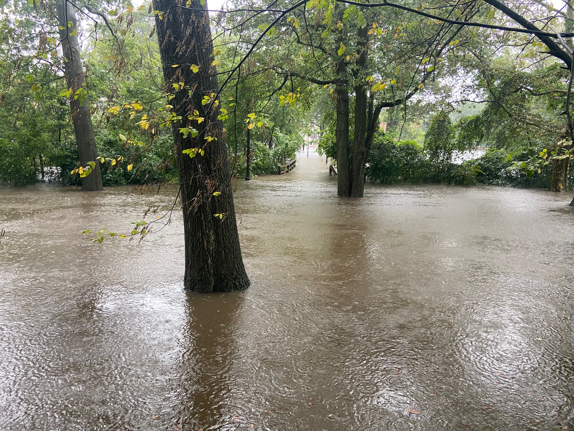
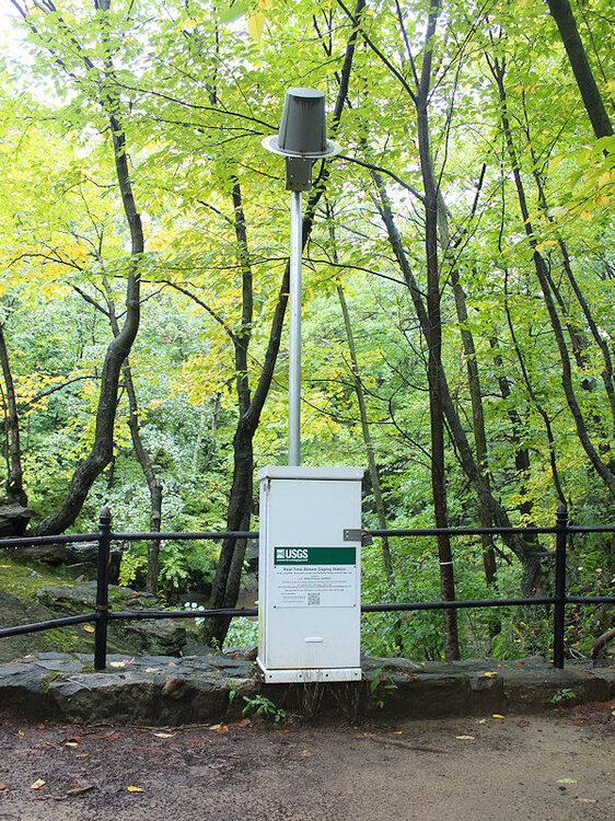
The normally quiet Sheldrake River in Larchmont, NY.

- 886 replies
-
- 4
-

-
- heavy rain
- flooding potential
- (and 2 more)
-
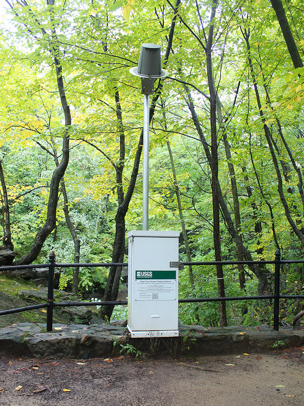
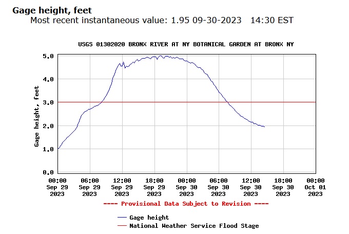
The Bronx River crested at 4.99 feet at the New York Botanical Garden. That was about 6" below the crest achieved from the remnants of Hurricane Ida in September 2021. The River remained at flood stage for about 12 hours.


- 886 replies
-
- 5
-
-
- heavy rain
- flooding potential
- (and 2 more)
-
A major to historic rainstorm is winding down. Excessive rainfall amounts include: Hartford: 3.74" (new daily record for September 29) New York City-Central Park: 5.58" (8th highest daily figure) New York City-JFK Airport: 8.05" (new all-time daily record) ***storm total: 8.67" (new 2-day record)*** New York City-LaGuardia Airport: 4.10" Tomorrow will be drier and the clouds could break. Afterward, a spell of warmer than normal weather lies ahead for much of the first week of October. There remain indications that colder air could push into the region afterward, possibly preceded by yet another storm. The ENSO Region 1+2 anomaly was +2.8°C and the Region 3.4 anomaly was +1.7°C for the week centered around September 20. For the past six weeks, the ENSO Region 1+2 anomaly has averaged +2.98°C and the ENSO Region 3.4 anomaly has averaged +1.55°C. El Niño conditions will likely continue to strengthen into the fall with the current East-based event transitioning to a basinwide El Niño for the upcoming winter. The SOI was -7.19 today. The preliminary Arctic Oscillation (AO) was +0.219 today. Based on sensitivity analysis applied to the latest guidance, there is an implied 82% probability that New York City will have a warmer than normal September (1991-2020 normal). September will likely finish with a mean temperature near 69.4° (0.2° above normal).
-
JFK’s daily rainfall: 7.83” (new all-time daily record). The old record of 7.80” was set on August 14, 2011.
- 886 replies
-
- 3
-
-
- heavy rain
- flooding potential
- (and 2 more)
-
JFK Airport has reached 7.26” rainfall today (2nd highest daily rainfall) and 7.88” storm total rainfall (highest two-day rainfall on record).
- 886 replies
-
- 1
-
-
- heavy rain
- flooding potential
- (and 2 more)
-
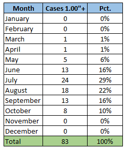
Below is the distribution of all 1" or greater hourly amounts by month:
- 886 replies
-
- 1
-

-
- heavy rain
- flooding potential
- (and 2 more)
-
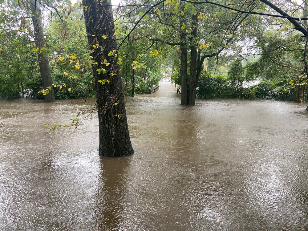
Columbus Park (Mamaroneck, NY). The Sheldrake and Mamaroneck Rivers are over their banks. Streets and buildings are starting to flood.
- 886 replies
-
- 9
-
-
- heavy rain
- flooding potential
- (and 2 more)
-
It ranks 6th highest, as earlier records are available for Central Park.
- 886 replies
-
- 5
-
-
-
- heavy rain
- flooding potential
- (and 2 more)
-
New York City picked up 1.02” of rain in the past hour. This is only the 4th time on record that 1” or more rain fell in two consecutive hours. The daily total of 4.94” is the 12th highest on record.
- 886 replies
-
- 2
-
-
-
- heavy rain
- flooding potential
- (and 2 more)
-
In the wake of Ophelia, cooler than normal weather will continue through much of the remainder of the month. As a result, September now looks to wind up near normal to somewhat warmer than normal. Another significant rainfall (generally 1"-3" is likely in the region Friday into Saturday). In the medium and longer range, a warmer than normal pattern will likely develop in eastern North America as October begins. The ENSO Region 1+2 anomaly was +2.8°C and the Region 3.4 anomaly was +1.7°C for the week centered around September 20. For the past six weeks, the ENSO Region 1+2 anomaly has averaged +2.98°C and the ENSO Region 3.4 anomaly has averaged +1.55°C. El Niño conditions will likely continue to strengthen into the fall with the current East-based event transitioning to a basinwide El Niño for the upcoming winter. The SOI was -3.21 today. The preliminary Arctic Oscillation (AO) was -0.096 today. Based on sensitivity analysis applied to the latest guidance, there is an implied 65% probability that New York City will have a warmer than normal September (1991-2020 normal). September will likely finish with a mean temperature near 69.5° (0.3° above normal).
-
The concurrent marine heatwaves may be undercutting the ENSO influence.
-
In the wake of Ophelia, cooler than normal weather will continue through much of the remainder of the month. As a result, September now looks to wind up near normal to somewhat warmer than normal. In the medium and longer range, a warmer than normal pattern will likely develop in eastern North America as October begins. The ENSO Region 1+2 anomaly was +2.8°C and the Region 3.4 anomaly was +1.7°C for the week centered around September 20. For the past six weeks, the ENSO Region 1+2 anomaly has averaged +2.98°C and the ENSO Region 3.4 anomaly has averaged +1.55°C. El Niño conditions will likely continue to strengthen into the fall with the current East-based event transitioning to a basinwide El Niño for the upcoming winter. The SOI was -6.30 today. The preliminary Arctic Oscillation (AO) was -0.054 today. Based on sensitivity analysis applied to the latest guidance, there is an implied 64% probability that New York City will have a warmer than normal September (1991-2020 normal). September will likely finish with a mean temperature near 69.5° (0.3° above normal).
-
Ophelia's remaining showers will depart tomorrow. Afterward, drier air will return to the region. Additional rain is possible on Friday. In the wake of Ophelia, cooler than normal weather will continue through much of the remainder of the month. As a result, September now looks to wind up near normal to somewhat warmer than normal. In the medium and longer range, a warmer than normal pattern will likely develop in eastern North America as October begins. The ENSO Region 1+2 anomaly was +2.8°C and the Region 3.4 anomaly was +1.7°C for the week centered around September 20. For the past six weeks, the ENSO Region 1+2 anomaly has averaged +2.98°C and the ENSO Region 3.4 anomaly has averaged +1.55°C. El Niño conditions will likely continue to strengthen into the fall with the current East-based event transitioning to a basinwide El Niño for the upcoming winter. The SOI was -5.11 today. The preliminary Arctic Oscillation (AO) was -0.054 today. Based on sensitivity analysis applied to the latest guidance, there is an implied 63% probability that New York City will have a warmer than normal September (1991-2020 normal). September will likely finish with a mean temperature near 69.5° (0.3° above normal).
-
It is a stunning turnaround.
-
Through 5 pm, storm total rainfall from Ophelia included: Atlantic City: 3.71" Bridgeport: 0.24" Islip: 0.89" New York City: 1.79" Newark: 1.61" Philadelphia: 1.57" Additional rain and showers are likely into tomorrow. The latest HREF suggests a stripe of 2"-3" additional rainfall is likely across northeastern Pennsylvania into southeastern New York State, including northwest New Jersey. In the wake of Ophelia, cooler than normal weather will continue through much of the remainder of the month. As a result, September now looks to wind up near normal to somewhat warmer than normal. In the medium and longer range, a warmer than normal pattern could still develop in eastern North America as October begins. The ENSO Region 1+2 anomaly was +2.9°C and the Region 3.4 anomaly was +1.6°C for the week centered around September 6. For the past six weeks, the ENSO Region 1+2 anomaly has averaged +3.20°C and the ENSO Region 3.4 anomaly has averaged +1.38°C. El Niño conditions will likely continue to strengthen into the fall with the current East-based event transitioning to a basinwide El Niño for the upcoming winter. The SOI was -7.60 today. The preliminary Arctic Oscillation (AO) was -0.054 today. Based on sensitivity analysis applied to the latest guidance, there is an implied 54% probability that New York City will have a warmer than normal September (1991-2020 normal). September will likely finish with a mean temperature near 69.5° (0.3° above normal).
-
Ophelia will continue to bring rain to the region into tomorrow. A general 1"-3" storm total rainfall is likely. Local amounts of 4" are possible. Through 8 pm, rainfall amounts include: Atlantic City: 3.11" (old record: 1.12", 1975) Baltimore: 1.19" Bridgeport: 0.09" Islip: 0.27" New York City: 0.90" Newark: 0.82" Philadelphia: 1.05" Richmond: 2.43" (old record: 2.08", 1975) Washington, DC: 1.35" Wilmington, DE: 1.18" Down South, Miami's record 56-day streak of 90° or above temperatures ended. The old record of 44 days was set during July 10-through August 22, 2011. Gusty winds and rough surf will continue to impact the Jersey Shore, Connecticut Shore, and Long Island. Coastal flooding is likely at high tide. Temperatures will hold mainly in the lower to middle 60s tomorrow. In the wake of the storm, cooler than normal weather will continue through much of the remainder of the month. As a result, September now looks to wind up somewhat warmer than normal, but noticeably cooler than had been the case on the guidance even a few days ago. In the medium and longer range, a warmer than normal pattern could still develop in eastern North America as September concludes and October begins. The ENSO Region 1+2 anomaly was +2.9°C and the Region 3.4 anomaly was +1.6°C for the week centered around September 6. For the past six weeks, the ENSO Region 1+2 anomaly has averaged +3.20°C and the ENSO Region 3.4 anomaly has averaged +1.38°C. El Niño conditions will likely continue to strengthen into the fall with the current East-based event transitioning to a basinwide El Niño for the upcoming winter. The SOI was -13.25 today. The preliminary Arctic Oscillation (AO) was -0.237 today. Based on sensitivity analysis applied to the latest guidance, there is an implied 63% probability that New York City will have a warmer than normal September (1991-2020 normal). September will likely finish with a mean temperature near 69.8° (0.6° above normal).
-
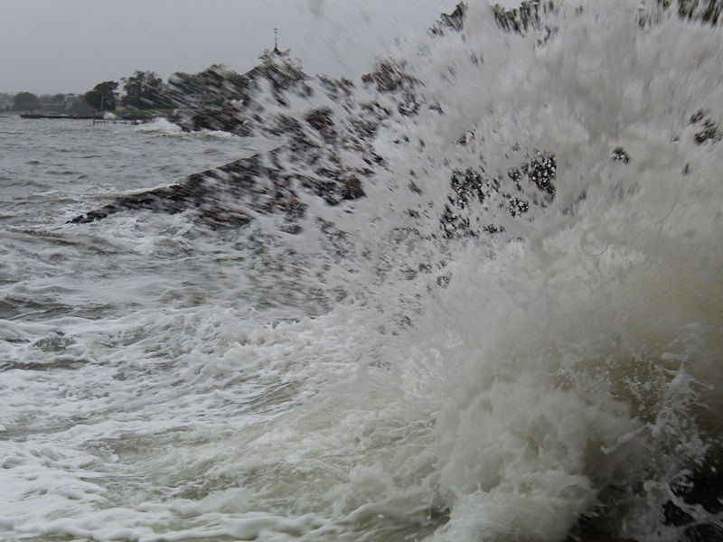
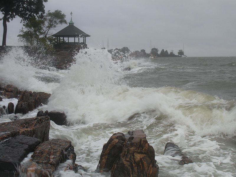
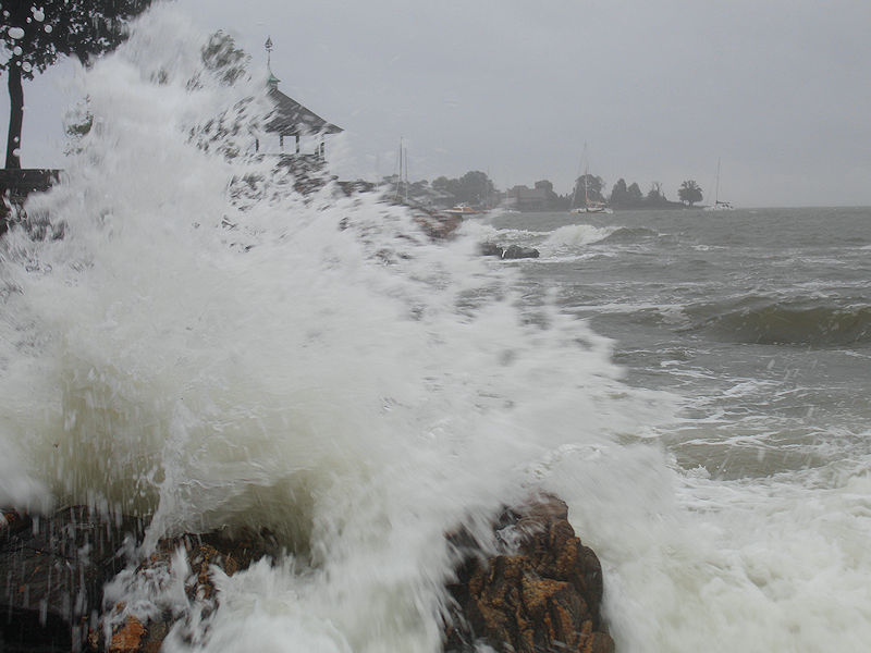
Four photos from late this afternoon.

- 465 replies
-
- 10
-