donsutherland1
-
Posts
24,194 -
Joined
Content Type
Profiles
Blogs
Forums
American Weather
Media Demo
Store
Gallery
Everything posted by donsutherland1
-
Under bright sunshine, readings topped out in the upper 70s and lower 80s today. Fair and pleasant days coupled with low humidity will continue through at least midweek. No significant hot weather appears likely through the first week of August. The extreme heat event that has gripped the Southwest for four weeks is concluding. Phoenix reached 110° for the 31st consecutive day a short time ago, but will likely stay below 110° tomorrow through Tuesday. However, the respite appears likely to be short-lived. As has often occurred in areas witnessing prolonged sieges of heat in recent years, extreme heat will likely rebuild later in the week. The ENSO Region 1+2 anomaly was +3.5°C and the Region 3.4 anomaly was +1.1°C for the week centered around July 19. For the past six weeks, the ENSO Region 1+2 anomaly has averaged +3.12°C and the ENSO Region 3.4 anomaly has averaged +1.00°C. El Niño conditions have developed and will likely continue to strengthen through at least the summer. The probability of an East-based El Niño event has increased. The SOI was +8.86 today. The preliminary Arctic Oscillation (AO) was +0.120 today. On July 28 the MJO was in Phase 8 at an amplitude of 0.304 (RMM). The July 27-adjusted amplitude was 0.374 (RMM). Based on sensitivity analysis applied to the latest guidance, there is an implied near 100% probability that New York City will have a warmer than normal July (1991-2020 normal). July will likely finish with a mean temperature near 79.0° (1.5° above normal).
-
I’m pretty sure it is an ash. I came across it during a morning walk. Limbs were downed in Scarsdale.
-
Uprooted tree from yesterday’s thunderstorm in southern Westchester County.


-
Following this evening's thunderstorm.


-
In the wake of the frontal passage, tomorrow will turn noticeably cooler and less humid. No significant hot weather appears likely through the first week of August. The extreme heat event that has gripped the Southwest for four weeks will conclude over the next day or perhaps two days. As has often occurred in areas witnessing prolonged sieges of heat in recent years, extreme heat could rebuild next week. The ENSO Region 1+2 anomaly was +3.5°C and the Region 3.4 anomaly was +1.1°C for the week centered around July 19. For the past six weeks, the ENSO Region 1+2 anomaly has averaged +3.12°C and the ENSO Region 3.4 anomaly has averaged +1.00°C. El Niño conditions have developed and will likely continue to strengthen through at least the summer. The probability of an East-based El Niño event has increased. The SOI was 0.00 today. The preliminary Arctic Oscillation (AO) was +0.163 today. On July 27 the MJO was in Phase 7 at an amplitude of 0.374 (RMM). The July 26-adjusted amplitude was 0.274 (RMM). Based on sensitivity analysis applied to the latest guidance, there is an implied near 100% probability that New York City will have a warmer than normal July (1991-2020 normal). July will likely finish with a mean temperature near 79.2° (1.7° above normal).
-
With the monsoonal moisture, it's unlikely. Monday and Tuesday will likely be in the 105-108 range. Heat should return afterward and the August monthly record high temperature could be challenged next Saturday. Phoenix will still have the warmest July in terms of average monthly temperature and average monthly low temperature of any U.S. city (Death Valley locations are hotter).
-
Tomorrow will be another very warm and humid day. However, strong thunderstorms could cross the region during the afternoon or evening as a cold front moves through. In the wake of the frontal passage, Sunday will turn noticeably cooler and less humid. The extreme heat event that has gripped the Southwest for four weeks is beginning to fade. The intense heat will continue to slowly fade over the coming days with the extreme heat ending on Sunday or Monday. As has often occurred in areas witnessing prolonged sieges of heat in recent years, there are some hints that the heat could rebuild next week. The ENSO Region 1+2 anomaly was +3.5°C and the Region 3.4 anomaly was +1.1°C for the week centered around July 19. For the past six weeks, the ENSO Region 1+2 anomaly has averaged +3.12°C and the ENSO Region 3.4 anomaly has averaged +1.00°C. El Niño conditions have developed and will likely continue to strengthen through at least the summer. The probability of an East-based El Niño event has increased. The SOI was -14.96 today. The preliminary Arctic Oscillation (AO) was +0.023 today. On July 26 the MJO was in Phase 8 at an amplitude of 0.275 (RMM). The July 25-adjusted amplitude was 0.219 (RMM). Based on sensitivity analysis applied to the latest guidance, there is an implied near 100% probability that New York City will have a warmer than normal July (1991-2020 normal). July will likely finish with a mean temperature near 79.3° (1.8° above normal).
-
A heatwave is continuing to develop in parts of the northern Mid-Atlantic region. Readings will likely climb into the middle and perhaps upper 90s again tomorrow. The humidity will add to the discomfort with heat indices again reaching or exceeding 105° tomorrow. The heatwave will not be a prolonged affair. Following a frontal passage on Saturday or Saturday night, Sunday will turn noticeably cooler and less humid. The extreme heat event that has gripped the Southwest for four weeks is beginning to fade. The intense heat will continue to slowly fade over the coming days with the extreme heat ending this weekend. As has often occurred in areas witnessing prolonged sieges of heat in recent years, there are some hints that the heat could rebuild next week. The ENSO Region 1+2 anomaly was +3.5°C and the Region 3.4 anomaly was +1.1°C for the week centered around July 19. For the past six weeks, the ENSO Region 1+2 anomaly has averaged +3.12°C and the ENSO Region 3.4 anomaly has averaged +1.00°C. El Niño conditions have developed and will likely continue to strengthen through at least the summer. The probability of an East-based El Niño event has increased. The SOI was -22.28 today. The preliminary Arctic Oscillation (AO) was -0.95 today. On July 25 the MJO was in Phase 7 at an amplitude of 0.215 (RMM). The July 24-adjusted amplitude was 0.280 (RMM). Based on sensitivity analysis applied to the latest guidance, there is an implied 98% probability that New York City will have a warmer than normal July (1991-2020 normal). July will likely finish with a mean temperature near 79.3° (1.8° above normal).
-
A heatwave is developing in parts of the northern Mid-Atlantic region. Readings will likely climb into the middle and perhaps upper 90s during the height of the heat. The humidity will add to the discomfort with heat indices reaching or exceeding 105° tomorrow and Friday. The heatwave will not be a prolonged affair. Following a frontal passage on Saturday or Saturday night, Sunday will turn noticeably cooler and less humid. An extreme heat event continues to grip the Southwest. Phoenix reached a daily record 118°. El Paso and Tucson recorded their 41st consecutive 100° days. The intense heat will slowly fade over the coming days with the extreme heat ending this weekend. As has often occurred in areas witnessing prolonged sieges of heat in recent years, there are some hints that the heat could rebuild next week. The ENSO Region 1+2 anomaly was +3.5°C and the Region 3.4 anomaly was +1.1°C for the week centered around July 19. For the past six weeks, the ENSO Region 1+2 anomaly has averaged +3.12°C and the ENSO Region 3.4 anomaly has averaged +1.00°C. El Niño conditions have developed and will likely continue to strengthen through at least the summer. The probability of an East-based El Niño event has increased. The SOI was -37.30 today. The preliminary Arctic Oscillation (AO) was +0.064 today. On July 24 the MJO was in Phase 7 at an amplitude of 0.225 (RMM). The July 23-adjusted amplitude was 0.245 (RMM). Based on sensitivity analysis applied to the latest guidance, there is an implied 97% probability that New York City will have a warmer than normal July (1991-2020 normal). July will likely finish with a mean temperature near 79.4° (1.9° above normal).
-
A heatwave is likely in parts of the northern Mid-Atlantic region. Parts of the region could see readings climb into the middle and perhaps upper 90s during the height of the heat. The humidity could add to the discomfort. At present, the potential heatwave does not appear to be a prolonged affair. An extreme heat event continues to grip the Southwest. Phoenix reached a daily record 119°. That was its third 119° temperature this year (old record: 2, 1990). El Paso and Tucson each registered their 40th consecutive 100° or above days, both of which are records. The ENSO Region 1+2 anomaly was +3.5°C and the Region 3.4 anomaly was +1.1°C for the week centered around July 19. For the past six weeks, the ENSO Region 1+2 anomaly has averaged +3.12°C and the ENSO Region 3.4 anomaly has averaged +1.00°C. El Niño conditions have developed and will likely continue to strengthen through at least the summer. The probability of an East-based El Niño event has increased. The SOI was -37.30 today. The preliminary Arctic Oscillation (AO) was +0.071 today. On July 23 the MJO was in Phase 7 at an amplitude of 0.245 (RMM). The July 22-adjusted amplitude was 0.479 (RMM). Based on sensitivity analysis applied to the latest guidance, there is an implied 97% probability that New York City will have a warmer than normal July (1991-2020 normal). July will likely finish with a mean temperature near 79.4° (1.9° above normal).
-
Warm weather will continue through tomorrow. A shower or thunderstorm is possible as warmer air pushes into the region. Afterward, a heatwave is likely in parts of the northern Mid-Atlantic region. The humidity could add to the discomfort. At present, the potential heatwave does not appear to be a prolonged affair. An extreme heat event continues to grip the Southwest. Phoenix reached a record-tying 116°. El Paso rang up its 39th consecutive 100° day. The ENSO Region 1+2 anomaly was +3.5°C and the Region 3.4 anomaly was +1.1°C for the week centered around July 19. For the past six weeks, the ENSO Region 1+2 anomaly has averaged +3.12°C and the ENSO Region 3.4 anomaly has averaged +1.00°C. El Niño conditions have developed and will likely continue to strengthen through at least the summer. The probability of an East-based El Niño event has increased. The SOI was -22.96 today. The preliminary Arctic Oscillation (AO) was +0.031 today. On July 22 the MJO was in Phase 8 at an amplitude of 0.478 (RMM). The July 21-adjusted amplitude was 0.343 (RMM). Based on sensitivity analysis applied to the latest guidance, there is an implied 95% probability that New York City will have a warmer than normal July (1991-2020 normal). July will likely finish with a mean temperature near 79.4° (1.9° above normal).
-
Mainly dry and warm weather will continue through Tuesday. Afterward, there is growing potential for the development of a heatwave in the northern Mid-Atlantic region. At present, the potential heatwave does not appear to be a prolonged affair. An extreme heat event continues to grip the Southwest. Las Vegas registered its record-tying 10th consecutive 110° day. Phoenix extended its record to 24 consecutive 110° days. El Paso's 100° streak reached 38 days. The ENSO Region 1+2 anomaly was +3.4°C and the Region 3.4 anomaly was +1.1°C for the week centered around July 12. For the past six weeks, the ENSO Region 1+2 anomaly has averaged +2.80°C and the ENSO Region 3.4 anomaly has averaged +0.97°C. El Niño conditions have developed and will likely continue to strengthen through at least the summer. The probability of an East-based El Niño event has increased. The SOI was -22.71 today. The preliminary Arctic Oscillation (AO) was +0.894 today. On July 21 the MJO was in Phase 1 at an amplitude of 0.346 (RMM). The July 20-adjusted amplitude was 0.032 (RMM). Based on sensitivity analysis applied to the latest guidance, there is an implied 93% probability that New York City will have a warmer than normal July (1991-2020 normal). July will likely finish with a mean temperature near 79.4° (1.9° above normal).
-
Very nice capture.
-
Tomorrow will be fair and warmer. There is some potential for the development of a heatwave in the northern Mid-Atlantic region during the second half of next week. An extreme heat event continues to grip the Southwest. Salt Lake City, which reached 105° so far today, could make a run at its all-time high temperature tomorrow. The ENSO Region 1+2 anomaly was +3.4°C and the Region 3.4 anomaly was +1.1°C for the week centered around July 12. For the past six weeks, the ENSO Region 1+2 anomaly has averaged +2.80°C and the ENSO Region 3.4 anomaly has averaged +0.97°C. El Niño conditions have developed and will likely continue to strengthen through at least the summer. The probability of an East-based El Niño event has increased. The SOI was -10.16 today. The preliminary Arctic Oscillation (AO) was +0.894 today. On July 20 the MJO was in Phase 2 at an amplitude of 0.037 (RMM). The July 19-adjusted amplitude was 0.252 (RMM). Based on sensitivity analysis applied to the latest guidance, there is an implied 91% probability that New York City will have a warmer than normal July (1991-2020 normal). July will likely finish with a mean temperature near 79.4° (1.9° above normal).
-
A fair and dry weekend lies ahead. An extreme heat event continues to grip the Southwest. Phoenix reached 117° today, its 22nd consecutive day with highs at or above 110°. Tucson also extended its record for 110° days to 13. Salt Lake City could make a run at its all-time high temperature tomorrow and Sunday. The ENSO Region 1+2 anomaly was +3.4°C and the Region 3.4 anomaly was +1.1°C for the week centered around July 12. For the past six weeks, the ENSO Region 1+2 anomaly has averaged +2.80°C and the ENSO Region 3.4 anomaly has averaged +0.97°C. El Niño conditions have developed and will likely continue to strengthen through at least the summer. The probability of an East-based El Niño event has increased. The SOI was -14.84 today. The preliminary Arctic Oscillation (AO) was +1.240 today. On July 19 the MJO was in Phase 4 at an amplitude of 0.245 (RMM). The July 18-adjusted amplitude was 0.509 (RMM). Based on sensitivity analysis applied to the latest guidance, there is an implied 81% probability that New York City will have a warmer than normal July (1991-2020 normal). July will likely finish with a mean temperature near 79.1° (1.6° above normal).
-
Report: Another Year of Record Heat for the Oceans
donsutherland1 replied to donsutherland1's topic in Climate Change
So far, it's been very difficult to build and sustain a WAR. Maybe that will change, but the persistence of the current pattern and repetition of ridge formation in areas that have seen a lot of it so far, suggest that the odds of a sustained WAR may not be great in the near term. Perhaps the probability could increase beyond mid August? -
Report: Another Year of Record Heat for the Oceans
donsutherland1 replied to donsutherland1's topic in Climate Change
What's happening at Marathon, in large part due to the extreme marine heatwave, is beyond description. So far, it's also had 8 98° or above days (the old record was 2). For its climate record prior to 2023 (begins in April 1950), there were 7 such days in total. Aside from AGW, a lack of Saharan dust allowed for more incoming solar radiation to reach the waters. Lack of storminess has also prevented the upwelling that could have cooled them. The volcano's impact is likely fading now. -
Cyclical or Natural Predictable Climate Change Forum
donsutherland1 replied to ChescoWx's topic in Climate Change
He’s wrong. The literature notes that UHI is strongest at night, not day. UHI is skewing low temperatures, but having only a small impact on high temperatures.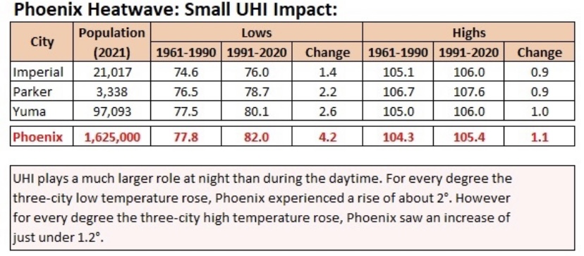
-
Report: Another Year of Record Heat for the Oceans
donsutherland1 replied to donsutherland1's topic in Climate Change
Yes. The extreme marine heatwave near Florida is absolutely shocking. A lot of coral and other marine life is at risk. And it’s contributing to the unrelenting heat in south Florida and the Florida Keys. -
Some showers or thundershowers are likely tomorrow. Some of the thunderstorms could be severe. Afterward, a fair and dry weekend will follow. An extreme heat event continues to grip the Southwest. Cities such as Las Vegas, Phoenix, and Tucson could see readings continue to rise toward or above their record daily levels over the next few days. Phoenix reached a sizzling 119° today on Day 21 of its longest heatwave on record. That smashed the daily record of 114° from 1978. In addition, Phoenix had a mean temperature of 105° or above for the fifth time this month. No year had more than two such days. The ENSO Region 1+2 anomaly was +3.4°C and the Region 3.4 anomaly was +1.1°C for the week centered around July 12. For the past six weeks, the ENSO Region 1+2 anomaly has averaged +2.80°C and the ENSO Region 3.4 anomaly has averaged +0.97°C. El Niño conditions have developed and will likely continue to strengthen through at least the summer. The probability of an East-based El Niño event has increased. The SOI was -18.65 today. The preliminary Arctic Oscillation (AO) was +1.035 today. On July 18 the MJO was in Phase 3 at an amplitude of 0.509 (RMM). The July 17-adjusted amplitude was 0.455 (RMM). Based on sensitivity analysis applied to the latest guidance, there is an implied 75% probability that New York City will have a warmer than normal July (1991-2020 normal). July will likely finish with a mean temperature near 79.1° (1.6° above normal).
-
Tomorrow will be mainly fair and warm days. Some showers or thundershowers are possible on Friday. Afterward, a fair and dry weekend will follow. An extreme heat event continues to grip the Southwest. Cities such as Las Vegas, Phoenix, and Tucson could see readings continue to rise toward or above their record daily levels over the next few days. Daily records included: Austin: 106° (tied record set in 2022) ***record 10th consecutive 105° day*** Brownsville: 101° (old record: 99°, 1918, 1978 and 2018) Corpus Christi: 100° (old record: 98°, 2000, 2009 and 2011) Del Rio: 107° (tied record set in 1951) El Paso: (old record: 107°, 2022) ***latest 110° reading on record*** Phoenix: 119° (old record: 116°, 1989) Roswell: 112° (old record: 109°, 2022) ***new July record*** Tucson: 112° (old record: 109°, 2009) The ENSO Region 1+2 anomaly was +3.4°C and the Region 3.4 anomaly was +1.1°C for the week centered around July 12. For the past six weeks, the ENSO Region 1+2 anomaly has averaged +2.80°C and the ENSO Region 3.4 anomaly has averaged +0.97°C. El Niño conditions have developed and will likely continue to strengthen through at least the summer. The probability of an East-based El Niño event has increased. The SOI was -20.38 today. The preliminary Arctic Oscillation (AO) was +0.703 today. On July 17 the MJO was in Phase 3 at an amplitude of 0.458 (RMM). The July 16-adjusted amplitude was 0.287 (RMM). Based on sensitivity analysis applied to the latest guidance, there is an implied 74% probability that New York City will have a warmer than normal July (1991-2020 normal). July will likely finish with a mean temperature near 79.1° (1.6° above normal).
-
So many records are being set. El Paso has blown its record for 100+ degree days out of the water (33 and counting).
-
Occasional Thoughts on Climate Change
donsutherland1 replied to donsutherland1's topic in Climate Change
Record-setting heat and concurrent heatwaves in the U.S. Southwest, Europe, and China has incinerated climate change denial narratives. With the climate change denial movement's rotten anti-science belief system melting from the hot reality of blistering heatwaves that they can no longer deny, they are busy flooding social media with false narratives in a desperate but futile pursuit of salvation from he laws of physics. The below example illustrates how some are trying to use bits of fact taken wildly out of context to deceive readers: Notice the focus on regional heatwaves. The heatwaves are no longer being denied. The intent is to compartmentalize the heatwaves as local phenomena. What's omitted--and it's a material omission--is the overall picture. Global temperatures are running at record highs through July 19. As a result, July 2023 is solidly on course to become the warmest July on record and likely warmest month on record on a global basis. The ongoing suffering of people caught in the withering heatwaves means nothing to those desperately seeking to deny reality. Their deliberate efforts to mislead e.g., in this case through the combination of select facts and a material omission, are appalling. Those efforts reflect a perspective that the victims of the extreme heat are expendable in the larger quest to construct a false reality. In the end, that indifference reflects badly on those pushing the disinformation, even as their disinformation discredits their capacity to discuss topics of weather and climate.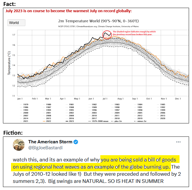
-
Tomorrow will be variably cloudy and warm. Some locations could experience a shower or thunderstorm. Afterward, the remainder of the week and weekend will be mainly dry. An extreme heat event continues to grip the Southwest. Cities such as Las Vegas, Phoenix, and Tucson could see readings continue to rise toward or above their record daily levels over the next few days. Today's highlights included: Austin: 107° (tied record set in 1918 and tied in 1923) Cotulla: 109° (old record: 107°, 2022) Del Rio: 108° (old record: 106°, 2018) El Paso: 109° (old record: 106°, 1980) Imperial: 117° (tied record set in 2009) Phoenix: 118° (old record: 115°, 1989) ***Record 19th consecutive 110° or above day*** Roswell: 111° (old record: 107°, 2019) ***Tied July record*** San Angelo: 110° (old record: 107°, 1989 and 2022) ***6th 110° or above day, which doubles the old record of 3 from 1944*** San Antonio: 104° (tied record set in 1918) Tucson: 112° (old record: 109°, 1989 and 1992) ***Record-tying 10th 110° or above day The ENSO Region 1+2 anomaly was +3.4°C and the Region 3.4 anomaly was +1.1°C for the week centered around July 12. For the past six weeks, the ENSO Region 1+2 anomaly has averaged +2.80°C and the ENSO Region 3.4 anomaly has averaged +0.97°C. El Niño conditions have developed and will likely continue to strengthen through at least the summer. The probability of an East-based El Niño event has increased. The SOI was -13.36 today. The preliminary Arctic Oscillation (AO) was +0.465 today. On July 16 the MJO was in Phase 3 at an amplitude of 0.288 (RMM). The July 15-adjusted amplitude was 0.407 (RMM). Based on sensitivity analysis applied to the latest guidance, there is an implied 76% probability that New York City will have a warmer than normal July (1991-2020 normal). July will likely finish with a mean temperature near 79.2° (1.7° above normal).
-
Tomorrow will be variably cloudy. Some showers or heavy thunderstorms are possible, especially during the afternoon. An extreme heat event continues to grip the Southwest. Cities such as Las Vegas, Phoenix, and Tucson could see readings continue to rise toward or above their record daily levels over the next few days. High temperatures included: Austin: 108° (old record: 105°, 1925 and 1984) Corpus Christi: 100° (tied record set in 1998) Del Rio: 107° (old record: 104°, 2009, 2020 and 2022) El Paso: 109° (old record: 106°, 1980) ***32nd consecutive 100° day*** Las Vegas: 114° Phoenix: 116° (tied record set in 2005) ***Record-tying 18th consecutive 110° day*** Salt Lake City: 105° Tucson: 111° (tied record set in 2005 The ENSO Region 1+2 anomaly was +3.4°C and the Region 3.4 anomaly was +1.1°C for the week centered around July 12. For the past six weeks, the ENSO Region 1+2 anomaly has averaged +2.80°C and the ENSO Region 3.4 anomaly has averaged +0.97°C. El Niño conditions have developed and will likely continue to strengthen through at least the summer. The probability of an East-based El Niño event has increased. The SOI was -7.70 today. The preliminary Arctic Oscillation (AO) was +0.465 today. On July 15 the MJO was in Phase 2 at an amplitude of 0.406 (RMM). The July 14-adjusted amplitude was 0.574 (RMM). Based on sensitivity analysis applied to the latest guidance, there is an implied 76% probability that New York City will have a warmer than normal July (1991-2020 normal). July will likely finish with a mean temperature near 79.2° (1.7° above normal).