donsutherland1
-
Posts
24,194 -
Joined
Content Type
Profiles
Blogs
Forums
American Weather
Media Demo
Store
Gallery
Everything posted by donsutherland1
-
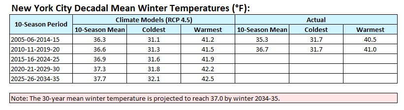
In a follow up to yesterday's post concerning snowfall trends (mainly in the Northeast), below are the climate model and actual 10-season winter temperature averages for New York City.
-
An extended period of generally cooler than normal temperatures is ongoing. No return to summerlike heat is likely through at least the first three weeks of June. Tomorrow will start fair but showers and perhaps a thundershower are likely late in the day or at night. Ahead of the showers, the sky could be whitened by wildfire smoke that will be passing aloft. The pleasantly warm readings will continue through the Juneteenth holiday. Parts of Texas are in the early stages of an extreme heat event. At present, there is no indication that this heat will move into the Middle Atlantic and southern New England regions. The ENSO Region 1+2 anomaly was +2.6°C and the Region 3.4 anomaly was +0.9°C for the week centered around June 7. For the past six weeks, the ENSO Region 1+2 anomaly has averaged +2.28°C and the ENSO Region 3.4 anomaly has averaged +0.58°C. El Niño conditions have developed and will likely continue to strengthen through at least the summer. The SOI was -4.92 today. The preliminary Arctic Oscillation (AO) was -0.427 today. On June 13 the MJO was in Phase 3 at an amplitude of 1.619 (RMM). The June 12-adjusted amplitude was 1.439 (RMM). Based on sensitivity analysis applied to the latest guidance, there is an implied 71% probability that New York City will have a cooler than normal June (1991-2020 normal). June will likely finish with a mean temperature near 70.8° (1.0° below normal).
-
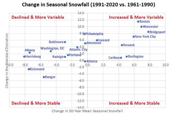
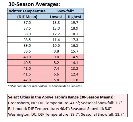
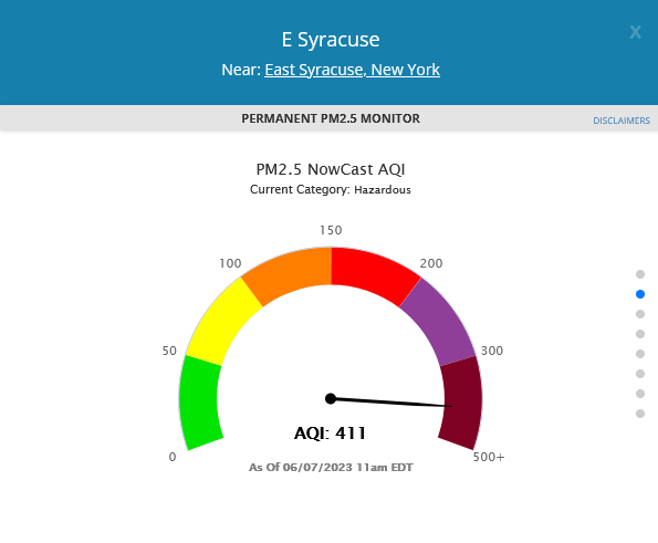
In the wake of record low seasonal snowfall for New York City (Central Park) and Bridgeport and the development of what could become a strong, and perhaps basin-wide El Niño event, it is worth looking back at how seasonal snowfall changed over the past 30 years relative to the prior 30-year period (1991-2020 vs. 1961-1990). In many parts of the Middle Atlantic region, seasonal snowfall had declined and variability of seasonal snowfall had increased. In the northern Mid-Atlantic and southern New England regions, seasonal snowfall had increased and variability in seasonal snowfall had increased. Bangor's figures have likely been impacted by the increasingly frequent and significant marine heatwaves off Maine's coast. As the climate continues to warm, cities such as New York City and Newark will likely see a decline in seasonal snowfall. That transition may already be in its early stages. By the mid-2030s, New York City's average seasonal snowfall could slip toward or below 20.0" based on rising winter temperatures. Mean seasonal snowfall and mean temperatures constructed from a regression equation (coefficient of determination: 0.836). When mean winter temperatures rise above 40.0°, seasonal snowfall totals could decrease and variability could also begin to decrease. That is the case with Atlanta and Richmond shown on the above chart and Greensboro listed on the below chart. Additional areas with mean winter temperatures of 40.0°F or above with decreased seasonal snowfall and decreased seasonal snowfall variability include Charleston (SC), Charlotte, and Wilmington (NC). Not all areas will likely see decreasing snowfall over the next decade. Central and northern New England could see additional increases in seasonal snowfall along with increased variability, as their winters remain colder than the thresholds at which seasonal snowfall begins to decline through at least the 2020s.
-
An extended period of generally cooler than normal temperatures is ongoing. No return to summerlike heat is likely through at least the first three weeks of June. Tomorrow will be fair and a bit warmer. The pleasantly warm readings will continue through the weekend. Parts of Texas are in the early stages of an extreme heat event. At present, there is no indication that this heat will move into the Middle Atlantic and southern New England regions. The ENSO Region 1+2 anomaly was +2.6°C and the Region 3.4 anomaly was +0.9°C for the week centered around June 7. For the past six weeks, the ENSO Region 1+2 anomaly has averaged +2.28°C and the ENSO Region 3.4 anomaly has averaged +0.58°C. El Niño conditions have developed and will likely continue to strengthen through at least the summer. The SOI was +1.41 today. The preliminary Arctic Oscillation (AO) was +0.279 today. On June 12 the MJO was in Phase 3 at an amplitude of 1.439 (RMM). The June 11-adjusted amplitude was 1.382 (RMM). Based on sensitivity analysis applied to the latest guidance, there is an implied 66% probability that New York City will have a cooler than normal June (1991-2020 normal). June will likely finish with a mean temperature near 71.0° (0.8° below normal).
-
An extended period of generally cooler than normal temperatures is ongoing. No return to summerlike heat is likely through at least the first three weeks of June. Tomorrow will be variably cloudy and a bit cooler. Some showers and thundershowers are possible. Texas could see near record and record heat develop during the middle and latter part of the week. Already, Laredo saw a near record 110° high today. At present, there is no indication that this heat will move into the Middle Atlantic and southern New England regions. The latest ECMWF weeklies continue to show no significant heat until at least late in the month. The ENSO Region 1+2 anomaly was +2.6°C and the Region 3.4 anomaly was +0.9°C for the week centered around June 7. For the past six weeks, the ENSO Region 1+2 anomaly has averaged +2.28°C and the ENSO Region 3.4 anomaly has averaged +0.58°C. El Niño conditions have developed and will likely continue to strengthen through at least the summer. The SOI was -1.69 today. The preliminary Arctic Oscillation (AO) was +0.601 today. On June 11 the MJO was in Phase 3 at an amplitude of 1.384 (RMM). The June 10-adjusted amplitude was 1.359 (RMM). Based on sensitivity analysis applied to the latest guidance, there is an implied 66% probability that New York City will have a cooler than normal June (1991-2020 normal). June will likely finish with a mean temperature near 71.0° (0.8° below normal).
-
An extended period of generally cooler than normal temperatures is ongoing. No return to summerlike heat is likely through at least the first three weeks of June. A frontal system will bring a general 0.25"-0.75" rainfall with locally higher overight into tomorrow. Some areas could experience thunder. The sun will return tomorrow. Texas could see near record and record heat develop during the middle and latter part of the week. At present, there is no indication that this heat will move into the Middle Atlantic and southern New England regions. The latest ECMWF weeklies continue to show no significant heat until at least late in the month. The ENSO Region 1+2 anomaly was +2.6°C and the Region 3.4 anomaly was +0.9°C for the week centered around June 7. For the past six weeks, the ENSO Region 1+2 anomaly has averaged +2.28°C and the ENSO Region 3.4 anomaly has averaged +0.58°C. El Niño conditions have developed and will likely continue to strengthen through at least the summer. The SOI was +10.54 today. The preliminary Arctic Oscillation (AO) was +0.102 today. On June 10 the MJO was in Phase 3 at an amplitude of 1.363 (RMM). The June 9-adjusted amplitude was 1.249 (RMM). Based on sensitivity analysis applied to the latest guidance, there is an implied 65% probability that New York City will have a cooler than normal June (1991-2020 normal). June will likely finish with a mean temperature near 71.1° (0.7° below normal).
-
Today will likely prove to be the warmest day this week. High temperatures included: New York City: 82°; Newark: 85°; Philadelphia: 89°; and, Washington, DC: 91°. Across the Atlantic, London reached 31°C (88°F) for the second consecutive day. No prior year had more than one 31°C temperature through June 15th. An extended period of generally cooler than normal temperatures is ongoing. No return to summerlike heat is likely through at least the first three weeks of June. A system will bring a general 0.25"-0.75" rainfall with locally higher amounts tomorrow into Tuesday. Some areas could experience thunder. The latest ECMWF weeklies have backed off the development of sustained warmer than normal conditions after the second week of June. The warmth is delayed until late in the month, but that's a low-skill forecasting range. The ENSO Region 1+2 anomaly was +2.3°C and the Region 3.4 anomaly was +0.8°C for the week centered around May 31. For the past six weeks, the ENSO Region 1+2 anomaly has averaged +2.25°C and the ENSO Region 3.4 anomaly has averaged +0.50°C. El Niño conditions have developed and will likely continue to strengthen through at least the summer. The SOI was +10.54 today. The preliminary Arctic Oscillation (AO) was -0.484 today. On June 9 the MJO was in Phase 3 at an amplitude of 1.254 (RMM). The June 8-adjusted amplitude was 1.274 (RMM). Based on sensitivity analysis applied to the latest guidance, there is an implied 59% probability that New York City will have a cooler than normal June (1991-2020 normal). June will likely finish with a mean temperature near 71.3° (0.7° below normal).
-
An extended period of generally cooler than normal temperatures is ongoing. No return to summerlike heat is likely through at least mid-month and likely beyond it. The generally dry weather will continue with perhaps a few showers or thundershowers through tomorrow. Tomorrow will likely be the warmest day of the week with widespread readings in the 80s. A general 0.50"-1.00" rainfall with locally higher amounts is likely Monday into Tuesday. The latest ECMWF weeklies have backed off the development of sustained warmer than normal conditions after the second week of June. The warmth is delayed until late in the month, but that's a low-skill forecasting range. The ENSO Region 1+2 anomaly was +2.3°C and the Region 3.4 anomaly was +0.8°C for the week centered around May 31. For the past six weeks, the ENSO Region 1+2 anomaly has averaged +2.25°C and the ENSO Region 3.4 anomaly has averaged +0.50°C. El Niño conditions have developed and will likely continue to strengthen through at least the summer. The SOI was +13.50 today. The preliminary Arctic Oscillation (AO) was -0.987 today. On June 8 the MJO was in Phase 2 at an amplitude of 1.277 (RMM). The June 7-adjusted amplitude was 1.593 (RMM). Based on sensitivity analysis applied to the latest guidance, there is an implied 57% probability that New York City will have a cooler than normal June (1991-2020 normal). June will likely finish with a mean temperature near 71.4° (0.6° below normal).
-
An extended period of generally cooler than normal temperatures is ongoing. No return to summerlike heat is likely through at least mid-month and likely beyond it. The generally dry weather will continue with perhaps a few showers or thundershowers through Sunday. Sunday will likely be the warmest day of the week with widespread readings in the 80s. There is potential for a moderate to significant rainfall Monday through Tuesday. The latest ECMWF weeklies have backed off the development of sustained warmer than normal conditions after the second week of June. The warmth is delayed until late in the month, but that's a low-skill forecasting range. The ENSO Region 1+2 anomaly was +2.3°C and the Region 3.4 anomaly was +0.8°C for the week centered around May 31. For the past six weeks, the ENSO Region 1+2 anomaly has averaged +2.25°C and the ENSO Region 3.4 anomaly has averaged +0.50°C. El Niño conditions have developed and will likely continue to strengthen through at least the summer. The SOI was +10.33 today. The preliminary Arctic Oscillation (AO) was -1.489 today. On June 7 the MJO was in Phase 2 at an amplitude of 1.593 (RMM). The June 6-adjusted amplitude was 1.591 (RMM). Based on sensitivity analysis applied to the latest guidance, there is an implied 59% probability that New York City will have a cooler than normal June (1991-2020 normal). June will likely finish with a mean temperature near 71.3° (0.7° below normal).
-
An extended period of generally cooler than normal temperatures is ongoing. No return to summerlike heat is likely through at least mid-month and likely beyond it. The generally dry weather will continue with perhaps a few showers or thundershowers through Saturday. There is growing potential for a significant rainfall Monday through Tuesday. The latest ECMWF weeklies have backed off the development of sustained warmer than normal conditions after the second week of June. The warmth is delayed until late in the month, but that's a low-skill forecasting range. The ENSO Region 1+2 anomaly was +2.3°C and the Region 3.4 anomaly was +0.8°C for the week centered around May 31. For the past six weeks, the ENSO Region 1+2 anomaly has averaged +2.25°C and the ENSO Region 3.4 anomaly has averaged +0.50°C. El Niño conditions are developing. The SOI was +8.22 today. The preliminary Arctic Oscillation (AO) was -1.628 today. On June 6 the MJO was in Phase 1 at an amplitude of 1.598 (RMM). The June 5-adjusted amplitude was 1.449 (RMM). Based on sensitivity analysis applied to the latest guidance, there is an implied 56% probability that New York City will have a cooler than normal June (1991-2020 normal). June will likely finish with a mean temperature near 71.4° (0.6° below normal).
-
Canon EOS 70d
-
An extended period of generally cooler than normal temperatures is ongoing. No return to summerlike heat is likely through at least mid-month. Tomorrow could start with additional smoke and haze. However, the New York City area has likely seen the worst of the smoke. The generally dry weather will continue with perhaps a few showers or thundershowers through Saturday. Early next week has potential for at least a moderate rainfall. The latest ECMWF weeklies suggest that sustained warmer than normal conditions could develop during or after the second week of June. The ENSO Region 1+2 anomaly was +2.3°C and the Region 3.4 anomaly was +0.8°C for the week centered around May 31. For the past six weeks, the ENSO Region 1+2 anomaly has averaged +2.25°C and the ENSO Region 3.4 anomaly has averaged +0.50°C. El Niño conditions are developing. The SOI was +6.75 today. The preliminary Arctic Oscillation (AO) was -1.540 today. On June 4 the MJO was in Phase 1 at an amplitude of 1.441 (RMM). The June 3-adjusted amplitude was 1.228 (RMM). Based on sensitivity analysis applied to the latest guidance, there is an implied 54% probability that New York City will have a cooler than normal June (1991-2020 normal). June will likely finish with a mean temperature near 71.5° (0.5° below normal).
-
Smoke from today:


-
View in the Bronx:

-
-
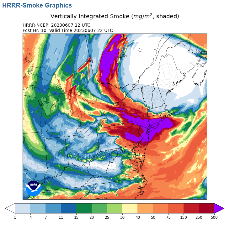
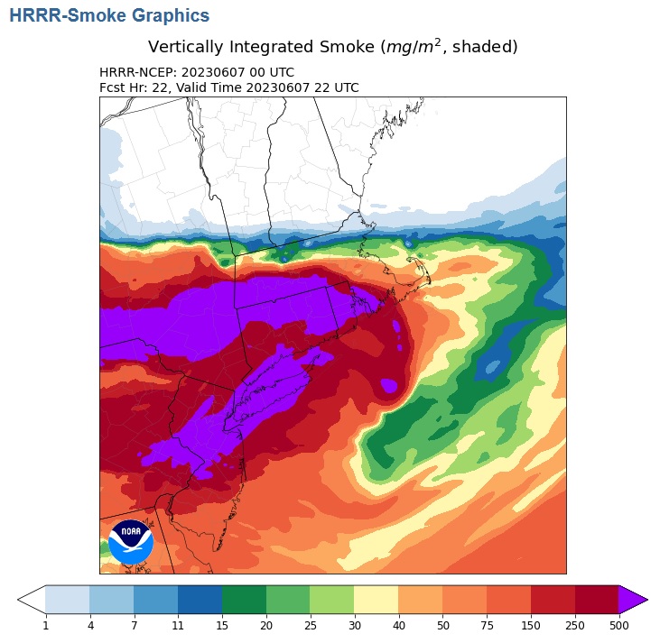
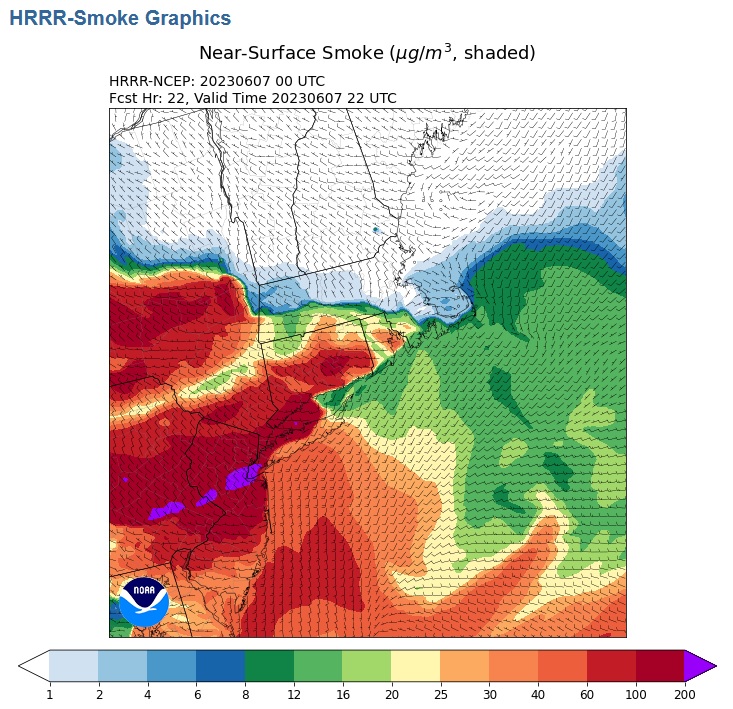
Smoke forecast for this evening:
-
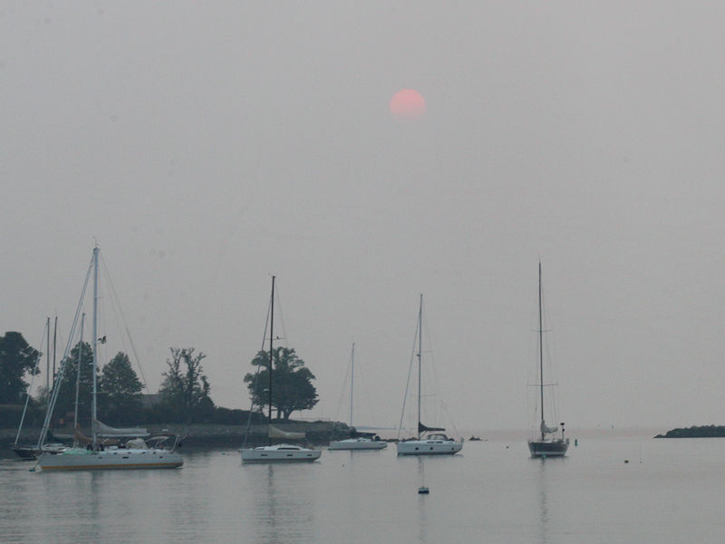
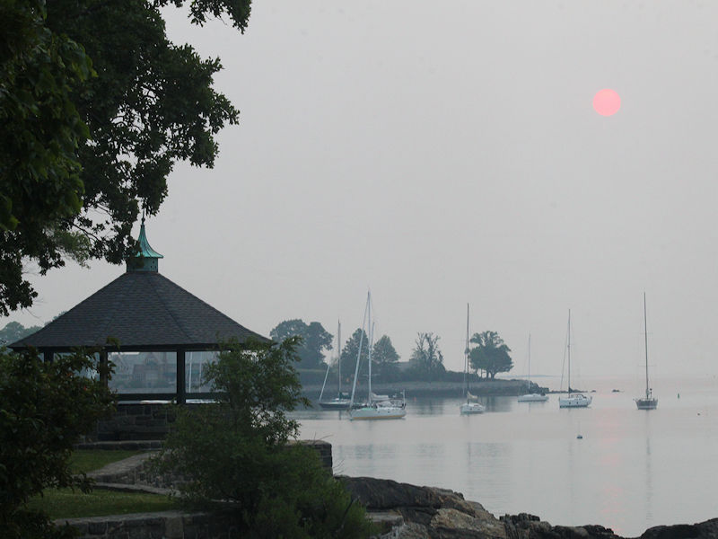
Another smoky sunrise.


-
The 5 boroughs.
-
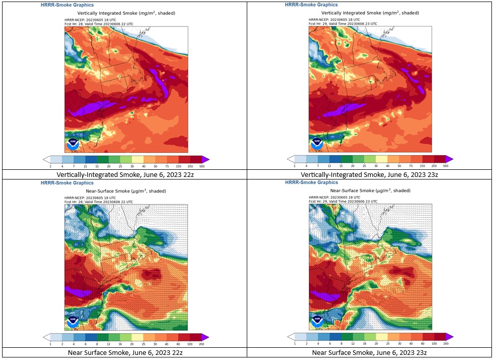
Tomorrow evening will again see very thick smoke in the New York City area.
-
An extended period of generally cooler than normal temperatures is ongoing. No return to summerlike heat is likely through at least mid-month. Tomorrow will be another smoky day in the region. The smoke could again be especially thick during the evening. The generally dry weather will continue, though early next week has some potential for at least a moderate rainfall. The latest ECMWF weeklies suggest that sustained warmer than normal conditions could develop during or after the second week of June. The ENSO Region 1+2 anomaly was +2.3°C and the Region 3.4 anomaly was +0.8°C for the week centered around May 31. For the past six weeks, the ENSO Region 1+2 anomaly has averaged +2.25°C and the ENSO Region 3.4 anomaly has averaged +0.50°C. El Niño conditions are developing. The SOI was -1.76 today. The preliminary Arctic Oscillation (AO) was -1.496 today.
-
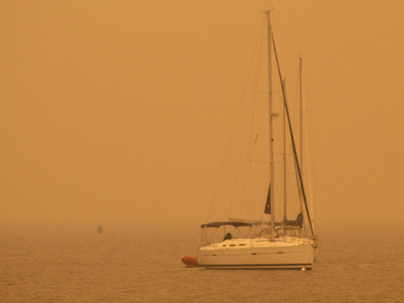
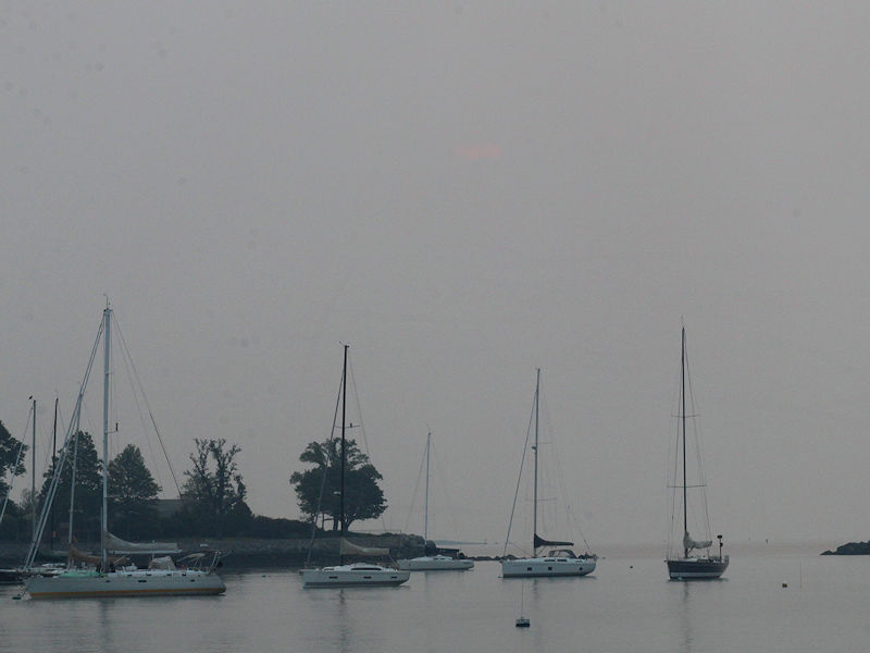
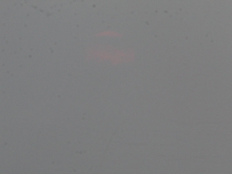
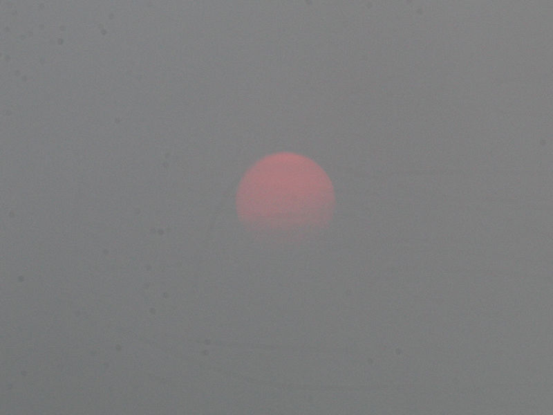
This evening, well before sunset, the thick smoke from Quebec's distant wildfires obscured the sun from view. The heavy musty smell of the acrid smoke hung through the air.

-
Some small hail is falling in Rye Brook and Port Chester, NY as a thunderstorm passes through. Pea-sized hail in Rye Brook (photo from Angella): Near dime-sized hail from Port Chester, NY (photo from Silvio).

-
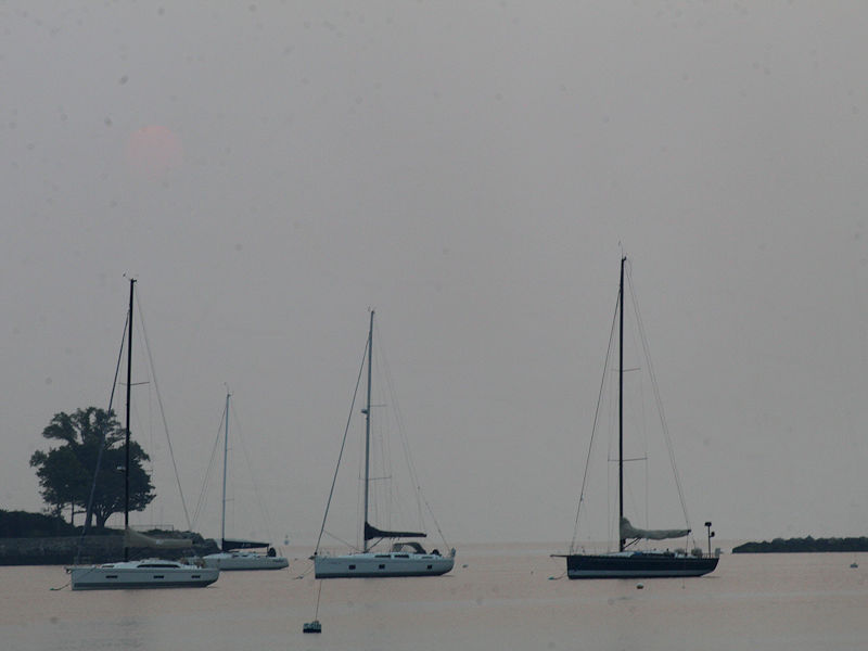
Smoky sunrise. The sun was not visible until 29 minutes after sunrise.
-
An extended period of generally cooler than normal temperatures is ongoing. No return to summerlike heat is likely through at least mid-month. Tomorrow will be partly sunny and pleasantly warm. However, thick smoke from ongoing Canadian wildfires will create for unhealthy air. The smoke could be especially thick in and around the New York City area during the evening rush hour. The latest ECMWF weeklies suggest that sustained warmer than normal conditions could develop during or after the second week of June. The ENSO Region 1+2 anomaly was +2.3°C and the Region 3.4 anomaly was +0.8°C for the week centered around May 31. For the past six weeks, the ENSO Region 1+2 anomaly has averaged +2.25°C and the ENSO Region 3.4 anomaly has averaged +0.50°C. El Niño conditions are developing. The SOI was -7.24 today. The preliminary Arctic Oscillation (AO) was -1.316 today. On June 3 the MJO data was not available. The June 2-adjusted amplitude was 1.205 (RMM) in Phase 1.
-
Evening rush hour could be quite smoky.