

donsutherland1
-
Posts
24,194 -
Joined
Content Type
Profiles
Blogs
Forums
American Weather
Media Demo
Store
Gallery
Everything posted by donsutherland1
-
Temperatures this morning tumbled to their lowest readings in June in more than 20 years in parts of the New York City area. At Central Park, the 49° low temperature was the first June reading below 50° since June 7, 2000 when the mercury fell to 49°. Low temperatures included: Montgomery: 38° (old record: 39°, 2019) New York City-Central Park: 49° New York City-JFK Airport: 49° (tied record set in 1976) New York City-LaGuardia Airport: 51° (tied record set in 1978 and tied in 1988 and 2003) White Plains: 44° (tied record set in 1964) Portland had a high temperature of 49° through 5 pm. The daily record low maximum temperature of 51° was set in 2018. If that high holds, today would be only the 6th day on record that Portland has had a high temperature below 50° in June. Records go back to 1874. The last such high temperature occurred on June 9, 1956. An extended period of generally cooler than normal temperatures is ongoing. No return to summerlike heat is likely through at least mid-month. The latest ECMWF weeklies suggest that sustained warmer than normal conditions could develop during or after the second week of June. The ENSO Region 1+2 anomaly was +2.0°C and the Region 3.4 anomaly was +0.4°C for the week centered around May 24. For the past six weeks, the ENSO Region 1+2 anomaly has averaged +2.28°C and the ENSO Region 3.4 anomaly has averaged +0.42°C. El Niño conditions will very likely develop during the summer. The SOI was -15.89 today. The preliminary Arctic Oscillation (AO) was -1.113 today. On June 2 the MJO was in Phase 1 at an amplitude of 1.205 (RMM). The June 1-adjusted amplitude was 1.237 (RMM).
-
That was the first June temperature in the 40s in the Park since June 7, 2000.
-
JFK (49), LGA (51), and HPN (44) tied their daily record low temperatures. MGJ (38) set a new record.
-
In the wake of a push of much cooler air, readings were confined to the 60s in the New York City area. Parts of New England saw high temperatures in the lower and middle 50s. Bangor's high temperature of 50° broke the record low maximum reading of 55°, which was set in 2015. An extended period of generally cooler than normal temperatures has now gotten underway. No return to heat rivaling that of yesterday is likely through at least mid-month. The latest ECMWF weeklies suggest that sustained warmer than normal conditions could develop during or after the second week of June. The ENSO Region 1+2 anomaly was +2.0°C and the Region 3.4 anomaly was +0.4°C for the week centered around May 24. For the past six weeks, the ENSO Region 1+2 anomaly has averaged +2.28°C and the ENSO Region 3.4 anomaly has averaged +0.42°C. El Niño conditions will very likely develop during the summer. The SOI was -13.43 today. The preliminary Arctic Oscillation (AO) was -0.870 today. On June 1 the MJO was in Phase 1 at an amplitude of 1.236 (RMM). The May 31-adjusted amplitude was 1.254 (RMM).
-
Under bright sunshine, temperatures soared into the 90s in parts of the region including New York City, Newark, and Philadelphia. Coastal areas were held into 70s and 80s. Parts of the region also saw record high temperatures. Records included: Allentown: 96° (tied record set in 1925) Baltimore: 97° (old record: 96°, 1923) Binghamton: 91° (old record: 88°, 1978) ***Earliest 90° and 91° on record*** Buffalo: 91° (old record: 87°, 1919) Hartford: 94° (old record: 91°, 1961) Mount Pocono: 88° (old record: 87°, 1937) Poughkeepsie: 95° (old record: 90°, 1934, 1944 and 2007) Reading: 96° (old record: 95°, 1925) Scranton: 95° (old record: 94°, 1919) ***Earliest 95° on record*** Sterling, VA: 93° (old record: 91°, 1978, 2000 and 2009) Syracuse: 90° (tied record set in 2014) Watertown, NY: 89° (old record: 87°, 1970) Westfield, MA: 93° (old record: 90°, 2000) Worcester: 89° (tied record set in 1892 and tied in 1895 and 1920) Andover and Soverville in New Jersey both topped out at 97°. The heat will be swept away as a trough develops leading to a return of sustained cooler than normal conditions. Some of the models show a fairly impressive cold shot for early June to start the weekend. As a result, Saturday could see temperatures remain in the 60s in New York City and 50s in Boston. The latest ECMWF weeklies suggest that sustained warmer than normal conditions could develop during or after the second week of June. The ENSO Region 1+2 anomaly was +2.0°C and the Region 3.4 anomaly was +0.4°C for the week centered around May 24. For the past six weeks, the ENSO Region 1+2 anomaly has averaged +2.28°C and the ENSO Region 3.4 anomaly has averaged +0.42°C. El Niño conditions will very likely develop during the summer. The SOI was -17.93 today. The preliminary Arctic Oscillation (AO) was -0.445 today. On May 31 the MJO was in Phase 8 at an amplitude of 1.258 (RMM). The May 30-adjusted amplitude was 1.113 (RMM).
-
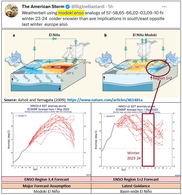
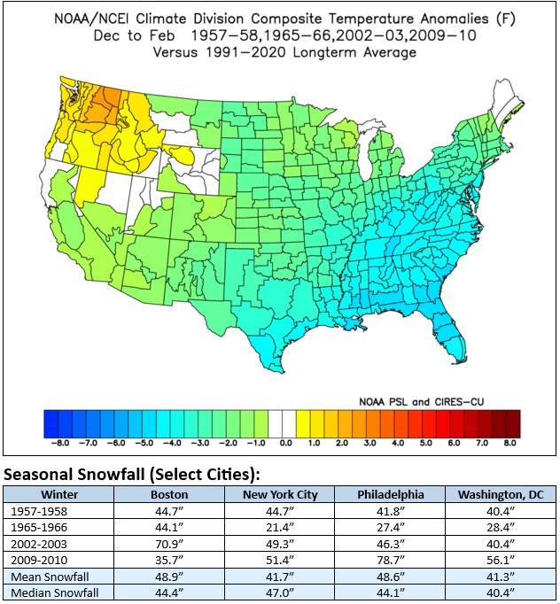
Summer has barely begun and Joe Bastardi is forecasting a cold and snowy Winter 2023-2024. His key assumption is that the evolving El Niño event will be a Modoki El Niño. Modoki events feature warm Region 3.4 anomalies and cold Region 1+2 anomalies. The latest ECMWF forecast calls for a basin-wide El Niño. At this time, it is far too soon to be sure about ENSO details (type and strength) other than the idea that an El Niño event will very likely develop. Seasonal forecasts typically have low skill, particularly when it comes to snowfall. Seasonal forecasts (modeling and forecaster) at this range do not have skill.
-
It is disappointing. Parts of PA have been even drier.
-
June started with above normal temperatures. The temperature rose into the 80s across much of the region. Some of the coastal areas saw temperatures hold in the upper 70s. Again, near record and record heat prevailed north of the region across parts of northern New England and southern Canada. Records included: Augusta, ME: 93° (old record: 92°, 2013) Baie-Comeau, QC: 83° (old record: 77°, 2007) Binghamton: 87° (old record: 86°, 1954 and 2011) Burlington: 96° (old record: 90°, 2011 and 2013) ***highest so early in the season*** Caribou: 93° (old record: 87°, 1995) Edmundston, NB: 93° (old record: 83°, 2011) Fredericton, NB: 95° (old record: 91°, 1937) Houlton, ME: 93° (old record: 86°, 1937 and 2013) L'Acadie, QC: 94° (old record: 88°, 2011) L'Assomption, QC: 97° (old record: 87°, 2011) Lebanon, NH: 96° (old record: 93°, 2013 Massena, NY: 91° (old record: 87°, 2018) Millinocket, ME: 96° (old record: 92°, 1920 and 1937) Miramichi, NB: 95° (old record: 91°, 2018) Montpelier: 90° (old record: 88°, 2013) Montreal: 94° (old record: 89°, 1892) Ottawa: 95° (old record: 92°, 1920) Plattsburgh: 90° (tied record set in 2013) Quebec City: 93° (old record: 86°, 2011) Saranac Lake, NY: 90° (old record: 87°, 1920) Scranton: 93° (tied record set in 1937) Sherbrooke: 90° (old record: 87°, 2013) Syracuse: 91° (tied record set in 1954) Tomorrow will be even warmer with parts of the region approaching or reaching 90°. However, a trough will develop afterward leading to a return of cooler conditions. Some of the models show a fairly impressive cold shot for early June. As a result, Saturday could see temperatures remain in the 60s in New York City and 50s in Boston. The latest ECMWF weeklies suggest that sustained warmer than normal conditions could develop during or after the second week of June. The ENSO Region 1+2 anomaly was +2.0°C and the Region 3.4 anomaly was +0.4°C for the week centered around May 24. For the past six weeks, the ENSO Region 1+2 anomaly has averaged +2.28°C and the ENSO Region 3.4 anomaly has averaged +0.42°C. El Niño conditions will very likely develop during the summer. The SOI was -25.94 today. The preliminary Arctic Oscillation (AO) was +0.153 today. On May 30 the MJO was in Phase 8 at an amplitude of 1.112 (RMM). The May 29-adjusted amplitude was 1.353 (RMM).
-
Harrisburg (0.19”), Philadelphia (0.24”), Reading (0.09”), and Wilmington, DE (0.20”) are concluding their driest Spring month on record.
-
Fair and warm conditions prevailed throughout much of the Middle Atlantic region. New York City finished with a monthly mean temperature of 62.7°, which was 0.5° below normal. Across northern Maine, New Brunswick, and Quebec, record-breaking heat was the story. Record highs included: Caribou: 91°; Miramichi, NB: 92°; and, Sept-Îles, QC: 87° (May monthly record). June will start with above normal temperatures, but a trough will likely develop leading to a return of cooler conditions shortly afterward. Some of the models show a fairly impressive cold shot for early June. The latest ECMWF weeklies suggest that sustained warmer than normal conditions could develop during or after the second week of June. The ENSO Region 1+2 anomaly was +2.0°C and the Region 3.4 anomaly was +0.4°C for the week centered around May 24. For the past six weeks, the ENSO Region 1+2 anomaly has averaged +2.28°C and the ENSO Region 3.4 anomaly has averaged +0.42°C. El Niño conditions will very likely develop during the summer. The SOI was -29.32 today. The preliminary Arctic Oscillation (AO) was +0.664 today. On May 29 the MJO was in Phase 8 at an amplitude of 1.358 (RMM). The May 28-adjusted amplitude was 1.647 (RMM).
-
DCA _ NYC _ BOS __ ORD _ ATL _ IAH ___ DEN _ PHX _ SEA -0.1 0.5 0.8 0.5 -0.5 -0.2 -3.2 -1.5 2.0 101 96 96 96 96 103 98 116 92
-
Temperatures will begin to rebound tomorrow. June will start with above normal temperatures, but a trough will likely develop leading to a return of cooler conditions shortly afterward. The latest ECMWF weeklies suggest that sustained warmer than normal conditions could develop during or after the second week of June. Typically, a very warm April is followed by a somewhat cooler than normal May in the Middle Atlantic region. The latest data suggests that May 2023 is now extremely likely to wind up somewhat cooler than normal. The ENSO Region 1+2 anomaly was +2.0°C and the Region 3.4 anomaly was +0.4°C for the week centered around May 24. For the past six weeks, the ENSO Region 1+2 anomaly has averaged +2.28°C and the ENSO Region 3.4 anomaly has averaged +0.42°C. El Niño conditions will very likely develop during the summer. The SOI was -15.45 today. The preliminary Arctic Oscillation (AO) was +1.057 today. On May 28 the MJO was not available. The May 27-adjusted amplitude was 1.796 (RMM). Based on sensitivity analysis applied to the latest guidance, there is an implied nera 100% probability that New York City will have a cooler than normal May (1991-2020 normal). May will likely finish with a mean temperature near 62.8° (0.4° below normal).
-
Tomorrow will be somewhat cooler in the Middle Atlantic region, but temperatures will begin to rebound on Wednesday. June could start with above normal temperatures, but a trough will likely develop leading to a return of cooler conditions shortly afterward. The latest ECMWF weeklies suggest that sustained warmer than normal conditions could develop during or after the second week of June. Typically, a very warm April is followed by a somewhat cooler than normal May in the Middle Atlantic region. The latest data suggests that May 2023 is now extremely likely to wind up somewhat cooler than normal. The ENSO Region 1+2 anomaly was +2.0°C and the Region 3.4 anomaly was +0.4°C for the week centered around May 24. For the past six weeks, the ENSO Region 1+2 anomaly has averaged +2.28°C and the ENSO Region 3.4 anomaly has averaged +0.42°C. El Niño conditions will very likely develop during the summer. The SOI was -0.82 today. The preliminary Arctic Oscillation (AO) was +1.369 today. On May 27 the MJO was in Phase 7 at an amplitude of 1.796 (RMM). The May 26-adjusted amplitude was 1.803 (RMM). Based on sensitivity analysis applied to the latest guidance, there is an implied 93% probability that New York City will have a cooler than normal May (1991-2020 normal). May will likely finish with a mean temperature near 62.8° (0.4° below normal).
-
The combination of brilliant sunshine, warm temperatures, and a refreshing breeze made for a spectacular day at the New York Botanical Garden. Some photos:


- 709 replies
-
- 11
-

-
Under mainly sunny skies, temperatures rose into the upper 70s with some lower 80s. The generally warm and dry weather continue through the Memorial Day Holiday. Across central and upstate New York and central and northern New England, hot weather prevailed. High temperatures there included: Albany: 90° Bangor: 91° (old record: 90°, 1959) Boston: 86° Burlington: 89° Caribou: 86° Concord: 91° Hartford: 87° Manchester: 92° Portland: 89° Tuesday and Wednesday will be somewhat cooler days in the Middle Atlantic region. However, June could start with above normal temperatures, but a trough will likely develop leading to a return of cooler conditions shortly afterward. Typically, a very warm April is followed by a somewhat cooler than normal May in the Middle Atlantic region. The latest data suggests that May 2023 has a better than 2-in-3 chance of winding up somewhat cooler than normal. June could start off with very warm readings. Parts of the Middle Atlantic region could see the temperature approach or reach 90° on one or more days. The ENSO Region 1+2 anomaly was +1.7°C and the Region 3.4 anomaly was +0.5°C for the week centered around May 17. For the past six weeks, the ENSO Region 1+2 anomaly has averaged +2.40°C and the ENSO Region 3.4 anomaly has averaged +0.37°C. Neutral ENSO conditions will likely prevail through at least mid-spring. El Niño conditions will very likely develop during the summer. The SOI was +6.22 today. The preliminary Arctic Oscillation (AO) was +1.895 today. On May 26 the MJO was in Phase 7 at an amplitude of 1.802 (RMM). The May 25-adjusted amplitude was 2.143 (RMM). Based on sensitivity analysis applied to the latest guidance, there is an implied 71% probability that New York City will have a cooler than normal May (1991-2020 normal). May will likely finish with a mean temperature near 62.8° (0.4° below normal).
-
Both yesterday and 9/22/1897 were extraordinary days, especially as records go back to 1874. The information you provided is terrific.
-
Today is only the second day on which Savannah set or tied daily records for precipitation, lowest maximum temperature, and lowest minimum temperature on the same date. The only other date was September 22, 1897 when 2.30" of rain fell, the low was 46 and the high was 54.
-
A strong storm with a warm core but frontal boundaries rendering it non-tropical brought heavy rain and unseasonably cool conditions to parts of the Southeast. At Savannah, the daily low temperature was 53°, which tied the daily record set in 1961. The high temperature so far has been 61°, which is well below the record low maximum temperature of 68° from 1972. Rainfall has amounted to 1.38", which broke the old record of 1.25" from 1996. In the northern Middle Atlantic region, sunshine and warm temperatures prevailed. The generally warm and dry weather will likely continue through the weekend and Memorial Day Holiday. Typically, a very warm April is followed by a somewhat cooler than normal May in the Middle Atlantic region. The latest data suggests that May 2023 has a better than 2-in-3 chance of winding up somewhat cooler than normal. June could start off with very warm readings. Parts of the Middle Atlantic region could see the temperature approach or reach 90° on one or more days. The ENSO Region 1+2 anomaly was +1.7°C and the Region 3.4 anomaly was +0.5°C for the week centered around May 17. For the past six weeks, the ENSO Region 1+2 anomaly has averaged +2.40°C and the ENSO Region 3.4 anomaly has averaged +0.37°C. Neutral ENSO conditions will likely prevail through at least mid-spring. El Niño conditions will very likely develop during the summer. The SOI was -2.05 today. The preliminary Arctic Oscillation (AO) was +1.660 today. On May 25 the MJO was in Phase 7 at an amplitude of 2.137 (RMM). The May 24-adjusted amplitude was 2.106 (RMM). Based on sensitivity analysis applied to the latest guidance, there is an implied 69% probability that New York City will have a cooler than normal May (1991-2020 normal). May will likely finish with a mean temperature near 62.9° (0.3° below normal).
-
The weekend will get off to a dry and warm start. Temperatures should top out in the middle and upper 70s across the region. The warming trend will continue through the weekend. Meanwhile, an area running along the South Carolina and North Carolina coastlines will see heavy windswept rain. Both Myrtle Beach and Wilmington could see record daily rainfall for May 27. Myrtle's record of 2.25" was set in 2020. Wilmington's mark of 3.02" was set in 1960. Typically, a very warm April is followed by a somewhat cooler than normal May in the Middle Atlantic region. The latest data suggests that May 2023 has a better than 2-in-3 chance of winding up somewhat cooler than normal. June could start off with very warm readings. Parts of the Middle Atlantic region could see the temperature approach or reach 90° on one or more days. The ENSO Region 1+2 anomaly was +1.7°C and the Region 3.4 anomaly was +0.5°C for the week centered around May 17. For the past six weeks, the ENSO Region 1+2 anomaly has averaged +2.40°C and the ENSO Region 3.4 anomaly has averaged +0.37°C. Neutral ENSO conditions will likely prevail through at least mid-spring. El Niño conditions will very likely develop during the summer. The SOI was -20.89 today. The preliminary Arctic Oscillation (AO) was +1.285 today. On May 24 the MJO was in Phase 7 at an amplitude of 2.105 (RMM). The May 23-adjusted amplitude was 1.851 (RMM). Based on sensitivity analysis applied to the latest guidance, there is an implied 69% probability that New York City will have a cooler than normal May (1991-2020 normal). May will likely finish with a mean temperature near 62.9° (0.3° below normal).
-
Tomorrow will be fair somewhat milder. The temperature will top out in the lower 70s. The warming trend will continue through the weekend. Typically, a very warm April is followed by a somewhat cooler than normal May in the Middle Atlantic region. With the guidance now showing a late week cool shot, the probability of a somewhat cooler than normal May has continued to increase. The ENSO Region 1+2 anomaly was +1.7°C and the Region 3.4 anomaly was +0.5°C for the week centered around May 17. For the past six weeks, the ENSO Region 1+2 anomaly has averaged +2.40°C and the ENSO Region 3.4 anomaly has averaged +0.37°C. Neutral ENSO conditions will likely prevail through at least mid-spring. El Niño conditions will very likely develop during the summer. The SOI was -45.48 today. The preliminary Arctic Oscillation (AO) was +1.296 today. On May 23 the MJO was in Phase 7 at an amplitude of 1.850 (RMM). The May 22-adjusted amplitude was 1.479 (RMM). Based on sensitivity analysis applied to the latest guidance, there is an implied 62% probability that New York City will have a cooler than normal May (1991-2020 normal). May will likely finish with a mean temperature near 63.0° (0.2° below normal).
-
An evening shower in some locations will usher in a noticeably cooler air mass. Overnight, readings will fall into the upper 40s and lower 50s in and near New York City and Newark. Outside the cities temperatures will fall into the lower and middle 40s. A few of the colder areas could see temperatures bottom out in the upper 30s. Tomorrow will be fair and cool for the season. The temperature will top out in the upper 60s to around 70°. Readings will likely remain below normal through the start of the weekend. Typically, a very warm April is followed by a somewhat cooler than normal May in the Middle Atlantic region. With the guidance now showing a late week cool shot, the probability of a somewhat cooler than normal May has continued to increase. The ENSO Region 1+2 anomaly was +1.7°C and the Region 3.4 anomaly was +0.5°C for the week centered around May 17. For the past six weeks, the ENSO Region 1+2 anomaly has averaged +2.40°C and the ENSO Region 3.4 anomaly has averaged +0.37°C. Neutral ENSO conditions will likely prevail through at least mid-spring. El Niño conditions will very likely develop during the summer. The SOI was -64.63 today. That is the lowest figure since the SOI plunged to -80.41 on February 5, 2010. The preliminary Arctic Oscillation (AO) was +1.792 today. On May 22 the MJO was in Phase 7 at an amplitude of 1.476 (RMM). The May 21-adjusted amplitude was 1.274 (RMM). Based on sensitivity analysis applied to the latest guidance, there is an implied 54% probability that New York City will have a cooler than normal May (1991-2020 normal). May will likely finish with a mean temperature near 63.0° (0.2° below normal).
-
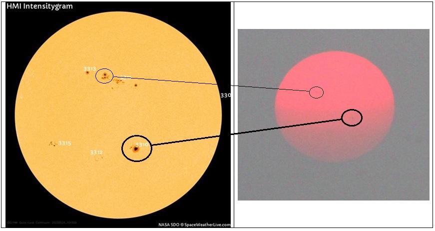
On one of the photos from this morning, some sunspots were faintly visible.
- 709 replies
-
- 11
-
-

-
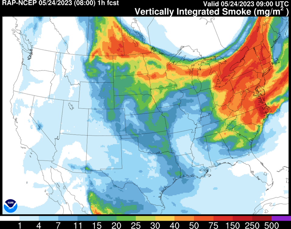
Very thick smoke from the wildfires in Alberta cloaked the sunrise in the New York City region this morning.


- 709 replies
-
- 12
-
-
-
Tomorrow will be partly cloudy and warm ahead of a push of cooler air. Some widely scattered showers are possible. Afterward, cooler air will overspread the region. Readings will likely remain below normal through the start of the weekend. Typically, a very warm April is followed by a somewhat cooler than normal May in the Middle Atlantic region. With the guidance now showing a late week cool shot, the probability of a somewhat cooler than normal May has continued to increase. The ENSO Region 1+2 anomaly was +1.7°C and the Region 3.4 anomaly was +0.5°C for the week centered around May 17. For the past six weeks, the ENSO Region 1+2 anomaly has averaged +2.40°C and the ENSO Region 3.4 anomaly has averaged +0.37°C. Neutral ENSO conditions will likely prevail through at least mid-spring. El Niño conditions will very likely develop during the summer. The SOI was -61.80 today. That is the lowest figure since the SOI plunged to -80.41 on February 5, 2010. The preliminary Arctic Oscillation (AO) was +1.712 today. On May 21 the MJO was in Phase 6 at an amplitude of 1.267 (RMM). The May 20-adjusted amplitude was 1.495 (RMM). Based on sensitivity analysis applied to the latest guidance, there is an implied 52% probability that New York City will have a cooler than normal May (1991-2020 normal). May will likely finish with a mean temperature near 63.0° (0.2° below normal).
-
Tomorrow will be fair and pleasant with readings reaching the upper 60s and lower 70s. After mid-week, cooler air will overspread the region. Typically, a very warm April is followed by a somewhat cooler than normal May in the Middle Atlantic region. With the guidance now showing a late week cool shot, the probability of a somewhat cooler than normal May has continued to increase. The ENSO Region 1+2 anomaly was +1.7°C and the Region 3.4 anomaly was +0.5°C for the week centered around May 17. For the past six weeks, the ENSO Region 1+2 anomaly has averaged +2.40°C and the ENSO Region 3.4 anomaly has averaged +0.37°C. Neutral ENSO conditions will likely prevail through at least mid-spring. El Niño conditions will very likely develop during the summer. The SOI was -43.11 today. The preliminary Arctic Oscillation (AO) was +1.449 today. On May 20 the MJO was in Phase 6 at an amplitude of 1.478 (RMM). The May 19-adjusted amplitude was 1.870 (RMM). Based on sensitivity analysis applied to the latest guidance, there is an implied 55% probability that New York City will have a cooler than normal May (1991-2020 normal). May will likely finish with a mean temperature near 62.8° (0.4° below normal).


