

donsutherland1
-
Posts
24,194 -
Joined
Content Type
Profiles
Blogs
Forums
American Weather
Media Demo
Store
Gallery
Everything posted by donsutherland1
-
A heavy downpour popped up and moved through Larchmont, NY. Another shower developed shortly afterward.
-
It will be steamy and very warm tomorrow through Thursday. Temperatures could reach or exceed 90° in parts of the region through Thursday. Shower and thundershower activity will become more limited. Afterward, near to somewhat above normal readings will likely prevail through mid-month. The hottest weather so far now covers the Desert Southwest. Phoenix reached a near-record 116° today. That was its hottest reading since June 19, 2021 when the mercury also topped out at 116°. Readings will continue to reach or exceed 110° through the remainder of the week. The ENSO Region 1+2 anomaly was +2.9°C and the Region 3.4 anomaly was +0.9°C for the week centered around June 28. For the past six weeks, the ENSO Region 1+2 anomaly has averaged +2.57°C and the ENSO Region 3.4 anomaly has averaged +0.82°C. El Niño conditions have developed and will likely continue to strengthen through at least the summer. The SOI was +6.09 today. The preliminary Arctic Oscillation (AO) was -0.493 today. On July 1 the MJO was in Phase 2 at an amplitude of 1.587 (RMM). The June 30-adjusted amplitude was 1.397 (RMM).
-
It will be steamy and very warm tomorrow through Thursday. Tomorrow could see some showers or thunderstorms. Temperatures could reach or exceed 90° in parts of the region through Thursday. Afterward, near to somewhat above normal readings will likely prevail through mid-month. The hottest weather so far now covers the Desert Southwest. Las Vegas topped out at 110° and Phoenix reached 115°. Death Valley finished with a high of 126°, the world's highest temperature so far this year. Tomorrow will likely see temperatures reach or exceed 115° in Phoenix and 120° in Death Valley. The ENSO Region 1+2 anomaly was +2.9°C and the Region 3.4 anomaly was +1.0°C for the week centered around June 21. For the past six weeks, the ENSO Region 1+2 anomaly has averaged +2.37°C and the ENSO Region 3.4 anomaly has averaged +0.77°C. El Niño conditions have developed and will likely continue to strengthen through at least the summer. The SOI was +16.80 today. The preliminary Arctic Oscillation (AO) was -0.101 today. On June 30 the MJO was in Phase 2 at an amplitude of 0.962 (RMM). The June 29-adjusted amplitude was 1.396 (RMM).
-
An advancing warm front will bring showers and thunderstorms to the region tonight through tomorrow night. Afterward, it will turn warmer than normal. The Tuesday-Thursday period could see temperatures reach or exceed 90° in parts of the region. Afterward, near to somewhat above normal readings will likely prevail through mid-month. The hottest weather so far has now moved into the Desert Southwest. Through 4 pm PST, Phoenix had a high temperature of 114°, which was just below the daily record of 115° from 1990. Phoenix could see temperatures reach or exceed 115° tomorrow and Monday. Death Valley will likely exceed 120°. The ENSO Region 1+2 anomaly was +2.9°C and the Region 3.4 anomaly was +1.0°C for the week centered around June 21. For the past six weeks, the ENSO Region 1+2 anomaly has averaged +2.37°C and the ENSO Region 3.4 anomaly has averaged +0.77°C. El Niño conditions have developed and will likely continue to strengthen through at least the summer. The SOI was +18.77 today. The preliminary Arctic Oscillation (AO) was +0.347 today. On June 29 the MJO was in Phase 2 at an amplitude of 0.962 (RMM). The June 28-adjusted amplitude was 0.831 (RMM).
-
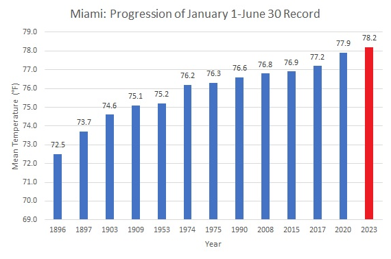
Miami recorded its warmest January 1-June 30 period on record. The prior record was set in 2020.
-
June finished with a mean temperature of 70.0° in New York City. That was 2.0° below normal. Temperatures will gradually warm toward seasonal levels during the first week of July. Afterward, near to somewhat above normal readings will likely prevail through mid-month. The Desert Southwest will likely see its hottest temperatures so far this year during the weekend into early next week. As has been the case throughout June, extreme heat appears unlikely in the northern Mid-Atlantic region for the foreseeable future. The ENSO Region 1+2 anomaly was +2.9°C and the Region 3.4 anomaly was +1.0°C for the week centered around June 21. For the past six weeks, the ENSO Region 1+2 anomaly has averaged +2.37°C and the ENSO Region 3.4 anomaly has averaged +0.77°C. El Niño conditions have developed and will likely continue to strengthen through at least the summer. The SOI was +17.22 today. The preliminary Arctic Oscillation (AO) was +0.693 today. On June 28 the MJO was in Phase 2 at an amplitude of 0.831 (RMM). The June 27-adjusted amplitude was 1.066 (RMM).
-
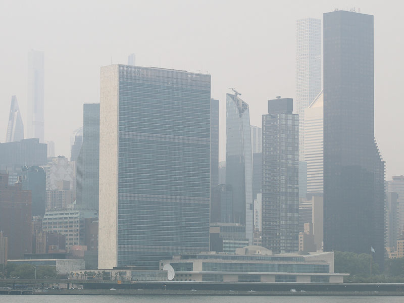
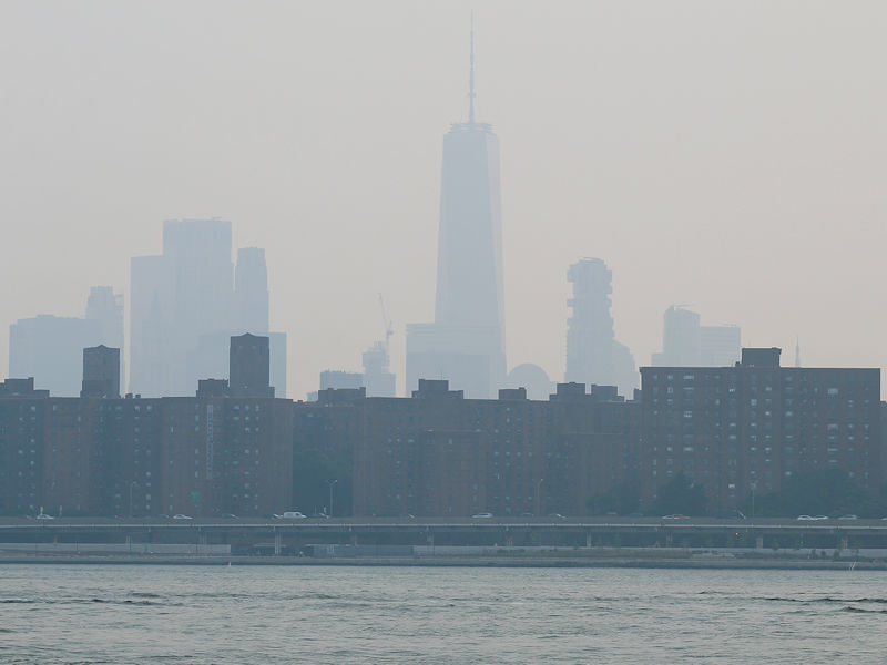
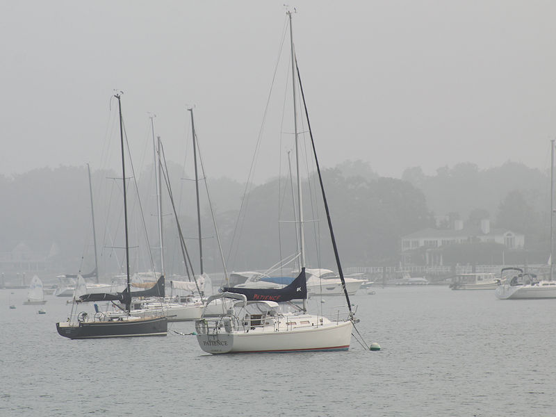
Wildfire smoke in New York City this afternoon. The AQI remained in the 160s throughout the afternoon.

-
July 2023 temperature forecast contest
donsutherland1 replied to Roger Smith's topic in Weather Forecasting and Discussion
DCA _ NYC _ BOS __ ORD _ ATL _ IAH ___ DEN _ PHX _ SEA 1.3 1.2 1.7 0.6 1.0 1.2 -0.8 1.0 2.5 -
Wildfire smoke in the New York area.


-
An extended period of generally cooler than normal temperatures is ongoing. No return to summerlike heat is likely through the remainder of June. However, temperatures will gradually warm toward seasonal levels during the first week of July. Afterward, near to somewhat above normal readings will likely prevail through mid-month. The Desert Southwest will likely see its hottest temperatures so far this year during the weekend into early next week. As has been the case throughout June, extreme heat appears unlikely in the northern Mid-Atlantic region for the foreseeable future. The ENSO Region 1+2 anomaly was +2.9°C and the Region 3.4 anomaly was +1.0°C for the week centered around June 21. For the past six weeks, the ENSO Region 1+2 anomaly has averaged +2.37°C and the ENSO Region 3.4 anomaly has averaged +0.77°C. El Niño conditions have developed and will likely continue to strengthen through at least the summer. The SOI was -0.35 today. The preliminary Arctic Oscillation (AO) was +0.753 today. On June 27 the MJO was in Phase 2 at an amplitude of 1.073 (RMM). The June 26-adjusted amplitude was 1.334 (RMM). Based on sensitivity analysis applied to the latest guidance, there is an implied near 100% probability that New York City will have a cooler than normal June (1991-2020 normal). June will likely finish with a mean temperature near 70.0° (2.0° below normal).
-
An extended period of generally cooler than normal temperatures is ongoing. No return to summerlike heat is likely through the remainder of June. However, temperatures will gradually warm toward seasonal levels during the first week of July. The ENSO Region 1+2 anomaly was +2.9°C and the Region 3.4 anomaly was +1.0°C for the week centered around June 21. For the past six weeks, the ENSO Region 1+2 anomaly has averaged +2.37°C and the ENSO Region 3.4 anomaly has averaged +0.77°C. El Niño conditions have developed and will likely continue to strengthen through at least the summer. The SOI was +1.41 today. The preliminary Arctic Oscillation (AO) was +0.842 today. On June 26 the MJO was in Phase 2 at an amplitude of 1.342 (RMM). The June 25-adjusted amplitude was 1.508 (RMM). Based on sensitivity analysis applied to the latest guidance, there is an implied near 100% probability that New York City will have a cooler than normal June (1991-2020 normal). June will likely finish with a mean temperature near 70.0° (2.0° below normal).
-
An extended period of generally cooler than normal temperatures is ongoing. No return to summerlike heat is likely through the remainder of June. Unsettled weather will likely continue through tomorrow. The temperature will approach seasonable levels tomorrow before cooling slightly. It will be humid with scattered showers and thundershowers tomorrow, some of which could be heavy. Parts of Texas remain in the midst of an extreme heat event. High temperatures included: Austin: 105° Brownsville: 99° Corpus Christi: 101° (tied record set in 1980 and tied in 2012) ***record 6th 100° June day*** Cotulla: 113° (old record: 109°, 1902) Del Rio: 110° (old record: 108°, 1980) ***10th consecutive record high*** Houston: 99° Junction: 106° (tied record set in 2012) Laredo: 110° (old record: 109°, 1980 and 1994) McAllen: 105° San Angelo: 109° (tied record set in 1994) San Antonio: 104° Victoria: 99° Zapata: 109° (tied record set in 1980) At present, there is little indication that this heat will move into the Middle Atlantic and southern New England regions. The ENSO Region 1+2 anomaly was +2.9°C and the Region 3.4 anomaly was +1.0°C for the week centered around June 21. For the past six weeks, the ENSO Region 1+2 anomaly has averaged +2.37°C and the ENSO Region 3.4 anomaly has averaged +0.77°C. El Niño conditions have developed and will likely continue to strengthen through at least the summer. The SOI was +10.89 today. The preliminary Arctic Oscillation (AO) was +0.888 today. On June 25 the MJO was in Phase 2 at an amplitude of 1.508 (RMM). The June 24-adjusted amplitude was 1.413 (RMM). Based on sensitivity analysis applied to the latest guidance, there is an implied near 100% probability that New York City will have a cooler than normal June (1991-2020 normal). June will likely finish with a mean temperature near 70.1° (1.7° below normal).
-
An extended period of generally cooler than normal temperatures is ongoing. No return to summerlike heat is likely through the remainder of June. Unsettled weather will likely continue through Wednesday. The temperature will approach seasonable levels tomorrow before cooling slightly. It will be humid with scattered showers and thundershowers tomorrow, some of which could be heavy. Parts of Texas remain in the midst of an extreme heat event. High temperatures included: Austin: 105° Brownsville: 99° Corpus Christi: 101° ***Record 5th 100° day in June*** Cotulla: 112° (old record: 109°, 2012) Del Rio: 111° (old record: 109°, 2012) ***9th consecutive record high*** Houston: 97° Junction: 106° Laredo: 109° McAllen: 103° Rio Grande Village: 118° (old record: 112°, 2011 and 2012) San Angelo: 112° (old record: 108°, 1918, 1994, and 2012) Victoria: 99° Zapata: 109° (old record: 108°, 1980) At present, there is little indication that this heat will move into the Middle Atlantic and southern New England regions. The ENSO Region 1+2 anomaly was +2.9°C and the Region 3.4 anomaly was +1.0°C for the week centered around June 21. For the past six weeks, the ENSO Region 1+2 anomaly has averaged +2.37°C and the ENSO Region 3.4 anomaly has averaged +0.77°C. El Niño conditions have developed and will likely continue to strengthen through at least the summer. The SOI was +16.24 today. The preliminary Arctic Oscillation (AO) was +0.596 today. On June 24 the MJO was in Phase 2 at an amplitude of 1.420 (RMM). The June 23-adjusted amplitude was 1.486 (RMM). Based on sensitivity analysis applied to the latest guidance, there is an implied near 100% probability that New York City will have a cooler than normal June (1991-2020 normal). June will likely finish with a mean temperature near 70.1° (1.7° below normal).
-
An extended period of generally cooler than normal temperatures is ongoing. No return to summerlike heat is likely through the remainder of June. Unsettled weather will likely continue through Tuesday. The temperature will approach seasonable levels tomorrow before cooling slightly. It will be humid with scattered showers and thundershowers tomorrow, some of which could be heavy. Parts of Texas remain in the midst of an extreme heat event. High temperatures through 6 pm CDT included: Austin: 103° Brownsville: 97° Corpus Christi: 99° Cortulla: 110° (old record: 106°, 2012) Del Rio: 110° (old record: 106°, 1994) Houston: 98° Junction: 104° Laredo: 109° (tied record set in 1994) Mcallen: 102° San Angelo: 111° (old record: 105°, 1994 and 2011) ***4th time pre-2023 all-time high as been reached*** San Antonio: 102° Victoria: 97° Zapata: 108° (old record: 106°, 1980) At present, there is little indication that this heat will move into the Middle Atlantic and southern New England regions. The ENSO Region 1+2 anomaly was +2.7°C and the Region 3.4 anomaly was +0.9°C for the week centered around June 14. For the past six weeks, the ENSO Region 1+2 anomaly has averaged +2.28°C and the ENSO Region 3.4 anomaly has averaged +0.67°C. El Niño conditions have developed and will likely continue to strengthen through at least the summer. The SOI was +13.21 today. The preliminary Arctic Oscillation (AO) was +0.173 today. On June 23 the MJO was in Phase 1 at an amplitude of 1.491 (RMM). The June 22-adjusted amplitude was 1.512 (RMM). Based on sensitivity analysis applied to the latest guidance, there is an implied 99% probability that New York City will have a cooler than normal June (1991-2020 normal). June will likely finish with a mean temperature near 70.1° (1.7° below normal).
-
Report: Another Year of Record Heat for the Oceans
donsutherland1 replied to donsutherland1's topic in Climate Change
New research has revealed that the Pacific marine heatwave known as “the Blob” was very likely the result of climate change. https://www.sciencealert.com/scientists-find-what-s-been-fueling-the-murderous-ocean-heatwave-called-the-blob -
An extended period of generally cooler than normal temperatures is ongoing. No return to summerlike heat is likely through the remainder of June. Unsettled weather will likely continue through Tuesday. The temperature will approach seasonable levels tomorrow before cooling slightly. It will be humid with scattered showers and thundershowers. Parts of Texas remain in the midst of an extreme heat event. High temperatures through 5 pm CDT included: Austin: 102° Brownsville: 98° Corpus Christi: 98° (tied record set in 1990 and tied in 2009 and 2012) Cotulla: 108° (old record: 107°, 2022) Del Rio: 107° (old record: 106°, 2018) ***7th consecutive record high*** Houston: 96° Junction: 102° Laredo: 107° McAllen: 102° San Angelo: 108° (old record: 107°, 1911, 1928, and 2018) San Antonio: 102° (tied record set in 1994 and tied in 2009) Victoria: 107° Zapata: 107° (tied record set in 1969) At present, there is little indication that this heat will move into the Middle Atlantic and southern New England regions. The ENSO Region 1+2 anomaly was +2.7°C and the Region 3.4 anomaly was +0.9°C for the week centered around June 14. For the past six weeks, the ENSO Region 1+2 anomaly has averaged +2.28°C and the ENSO Region 3.4 anomaly has averaged +0.67°C. El Niño conditions have developed and will likely continue to strengthen through at least the summer. The SOI was +5.27 today. The preliminary Arctic Oscillation (AO) was +0.665 today. On June 22 the MJO was in Phase 1 at an amplitude of 1.520 (RMM). The June 21-adjusted amplitude was 1.207 (RMM). Based on sensitivity analysis applied to the latest guidance, there is an implied 97% probability that New York City will have a cooler than normal June (1991-2020 normal). June will likely finish with a mean temperature near 70.1° (1.7° below normal).
-
An extended period of generally cooler than normal temperatures is ongoing. No return to summerlike heat is likely through the remainder of June. Showers and thundershowers will move through the region this evening and early tonight. The unsettled weather will likely continue through the weekend. The temperature will approach seasonable levels. It will be humid with scattered showers and thundershowers. Parts of Texas remain in the midst of an extreme heat event. High temperatures through 5 pm CDT included: Austin: 99° Brownsville: 97° Corpus Christi: 96° Cotulla: 110° (old record: 107°, 2017) Del Rio: 108° (old record: 106°, 1953 and 2018) ***6th consecutive record high*** Houston: 97° Junction: 101° Laredo: 110° (old record: 109°, 2017) McAllen: 101° San Angelo: 106° San Antonio: 101° Zapata: 109° (old record: 107°, 1969) At present, there is little indication that this heat will move into the Middle Atlantic and southern New England regions. The ENSO Region 1+2 anomaly was +2.7°C and the Region 3.4 anomaly was +0.9°C for the week centered around June 14. For the past six weeks, the ENSO Region 1+2 anomaly has averaged +2.28°C and the ENSO Region 3.4 anomaly has averaged +0.67°C. El Niño conditions have developed and will likely continue to strengthen through at least the summer. The SOI was -16.03 today. The preliminary Arctic Oscillation (AO) was +1.161 today. On June 21 the MJO was in Phase 1 at an amplitude of 1.198 (RMM). The June 20-adjusted amplitude was 0.776 (RMM). Based on sensitivity analysis applied to the latest guidance, there is an implied 94% probability that New York City will have a cooler than normal June (1991-2020 normal). June will likely finish with a mean temperature near 70.2° (1.6° below normal).
-
An extended period of generally cooler than normal temperatures is ongoing. No return to summerlike heat is likely through the remainder of June. Tomorrow will see additional showers and perhaps thunderstorms. It will turn milder with readings rising well into the 70s across much of the region. The unsettled weather will likely continue into the weekend. Parts of Texas remain in the midst of an extreme heat event. High temperatures included: Abilene: 94° Austin: 94° Brownsville: 98° Corpus Christi: 100° (tied record set in 2017) ***Record 4th 100° June day*** Cotulla: 107° (old record: 106°, 2017) Del Rio: 108° (old record: 106°, 1953) ***5th consecutive record high*** Houston: 97° Junction: 101° Laredo: 109° (old record: 107°, 1990, 1998, and 2017) McAllen: 103° San Angelo: 107° (tied record set in 1969) San Antonio: 95° Victoria: 99° Zapata: 109° (old record: 107°, 1969 and 1980) At present, there is little indication that this heat will move into the Middle Atlantic and southern New England regions. The ENSO Region 1+2 anomaly was +2.7°C and the Region 3.4 anomaly was +0.9°C for the week centered around June 14. For the past six weeks, the ENSO Region 1+2 anomaly has averaged +2.28°C and the ENSO Region 3.4 anomaly has averaged +0.67°C. El Niño conditions have developed and will likely continue to strengthen through at least the summer. The SOI was -16.03 today. The preliminary Arctic Oscillation (AO) was +1.040 today. On June 20 the MJO was in Phase 8 at an amplitude of 0.775 (RMM). The June 19-adjusted amplitude was 0.357 (RMM). Based on sensitivity analysis applied to the latest guidance, there is an implied 91% probability that New York City will have a cooler than normal June (1991-2020 normal). June will likely finish with a mean temperature near 70.3° (1.5° below normal).
-
An extended period of generally cooler than normal temperatures is ongoing. No return to summerlike heat is likely through the remainder of June. Overnight and tomorrow will see showers and perhaps thunderstorms. It will be unseasonably cool. Temperatures tomorrow will likely stay below 70° in parts of the northern Mid-Atlantic region. The unsettled weather will likely continue into the weekend. Parts of Texas are in the midst of an extreme heat event. High temperatures through 5 pm CDT included: Abilene: 103° Austin: 103° Brownsville: 99° Corpus Christi: 103° (old record: 102°, 2017) Cotulla: 115° (old record: 104°, 2022) Del Rio: 115° (old record: 105°, 1951 and 1996) ***New all-time record*** Houston: 100° (tied record set in 1902 and tied in 1906 and 1998) Junction: 110° (old record: 104°, 1953) Laredo: 112° (old record: 109°, 1996) McAllen: 107° (tied record set in 2017) San Angelo: 114° (old record: 108°, 1934) ***Tied all-time record*** San Antonio: 105° Victoria: 100° Zapata: 113° (old record: 107°, 1998) At present, there is little indication that this heat will move into the Middle Atlantic and southern New England regions. The ENSO Region 1+2 anomaly was +2.7°C and the Region 3.4 anomaly was +0.9°C for the week centered around June 14. For the past six weeks, the ENSO Region 1+2 anomaly has averaged +2.28°C and the ENSO Region 3.4 anomaly has averaged +0.67°C. El Niño conditions have developed and will likely continue to strengthen through at least the summer. The SOI was -26.99 today. The preliminary Arctic Oscillation (AO) was +0.179 today. On June 19 the MJO was in Phase 8 at an amplitude of 0.356 (RMM). The June 18-adjusted amplitude was 0.198 (RMM). Based on sensitivity analysis applied to the latest guidance, there is an implied 89% probability that New York City will have a cooler than normal June (1991-2020 normal). June will likely finish with a mean temperature near 70.3° (1.5° below normal).
-
An extended period of generally cooler than normal temperatures is ongoing. No return to summerlike heat is likely through the remainder of June. Tomorrow will be another fair day. Afterward, a potentially prolonged stretch of unsettled weather will develop. Parts of Texas are in the midst of an extreme heat event. High temperatures through 6 pm CDT included: Abilene: 108° (old record: 106°, 1934) Austin: 106° (tied record set in 1934) Brownsville: 98° Corpus Christi: 99° Cotulla: 115° (old record: 107°, 2019) Del Rio: 113° (old record: 106°, 1996 and 1998) ***New all-time record*** Houston: 100° Junction: 110° (old record: 104°, 1953) ***Record 6th 105°+ June day*** Laredo: 113° (old record: 109°, 1996 and 2011) McAllen: 106° (old record: 103°, 2017) San Angelo: 114° (old record: 110°, 1969) ***New all-time record*** San Antonio: 106° (old record: 103°, 1996) Victoria: 98° Zapata: 115° (old record: 107°, 1980) At present, there is little indication that this heat will move into the Middle Atlantic and southern New England regions. The ENSO Region 1+2 anomaly was +2.7°C and the Region 3.4 anomaly was +0.9°C for the week centered around June 14. For the past six weeks, the ENSO Region 1+2 anomaly has averaged +2.28°C and the ENSO Region 3.4 anomaly has averaged +0.67°C. El Niño conditions have developed and will likely continue to strengthen through at least the summer. The SOI was -22.71 today. The preliminary Arctic Oscillation (AO) was -0.631 today. On June 18 the MJO was in Phase 2 at an amplitude of 0.203 (RMM). The June 17-adjusted amplitude was 0.605 (RMM). Based on sensitivity analysis applied to the latest guidance, there is an implied 85% probability that New York City will have a cooler than normal June (1991-2020 normal). June will likely finish with a mean temperature near 70.5° (1.3° below normal).
-
I agree. It's brutal down there. I have some family and also friends in the Houston area. The combination of heat and humidity has been almost unbearable.
-
An extended period of generally cooler than normal temperatures is ongoing. No return to summerlike heat is likely through at least the first three weeks of June. Tomorrow will be another fair day. The pleasantly warm readings will continue through at least the coming weekend. Parts of Texas are in the midst of an extreme heat event. High temperatures through 5 pm CDT included: Austin: 103° Corpus Christi: 97° Cotulla: 114° (old record: 109°, 2019) Del Rio: 107° (old record: 106°, 1996 and 2011) Houston: 100° Junction: 106° (old record: 104°, 2011) ***Tied June record of 5 105° or above days*** Laredo: 114° (old record: 112°, 2011) San Angelo: 111° (old record: 109°, 1908) ***New June record, tied all-time record*** San Antonio: 104° (old record: 103°, 1918 and 2011) Zapata: 114° (old record: 107°, 1998) At present, there is little indication that this heat will move into the Middle Atlantic and southern New England regions. The ENSO Region 1+2 anomaly was +2.7°C and the Region 3.4 anomaly was +0.9°C for the week centered around June 14. For the past six weeks, the ENSO Region 1+2 anomaly has averaged +2.28°C and the ENSO Region 3.4 anomaly has averaged +0.67°C. El Niño conditions have developed and will likely continue to strengthen through at least the summer. The SOI was -19.47 today. The preliminary Arctic Oscillation (AO) was -1.127 today. On June 17 the MJO was in Phase 3 at an amplitude of 0.610 (RMM). The June 16-adjusted amplitude was 1.014 (RMM). Based on sensitivity analysis applied to the latest guidance, there is an implied 80% probability that New York City will have a cooler than normal June (1991-2020 normal). June will likely finish with a mean temperature near 70.8° (1.0° below normal).
-
An extended period of generally cooler than normal temperatures is ongoing. No return to summerlike heat is likely through at least the first three weeks of June. Tomorrow will be another fair day. The pleasantly warm readings will continue through at least Friday. Warmer conditions could begin to develop during the following weekend, but there is considerable uncertainty. Parts of Texas are in the midst of an extreme heat event. High temperatures included: Austin: 106° (old record: 105°, 2011) Corpus Christi: 96° Cotulla: 111° (old record: 108°, 2011) Del Rio: 111° (old record: 106°, 2011) ***Missed June and all-time record by 1°*** Falcon Lake: 117° (old record: 109°, 2017) ***New all-time record*** Houston: 99° Junction: 105° (tied record set in 2011) Laredo: 108° San Angelo: 102° San Antonio: 103° Zapata: 112° (old record: 106°, 1998) At present, there is little indication that this heat will move into the Middle Atlantic and southern New England regions. The ENSO Region 1+2 anomaly was +2.6°C and the Region 3.4 anomaly was +0.9°C for the week centered around June 7. For the past six weeks, the ENSO Region 1+2 anomaly has averaged +2.28°C and the ENSO Region 3.4 anomaly has averaged +0.58°C. El Niño conditions have developed and will likely continue to strengthen through at least the summer. The SOI was -26.43 today. The preliminary Arctic Oscillation (AO) was -1.105 today. On June 16 the MJO was in Phase 3 at an amplitude of 1.013 (RMM). The June 15-adjusted amplitude was 1.408 (RMM). Based on sensitivity analysis applied to the latest guidance, there is an implied 70% probability that New York City will have a cooler than normal June (1991-2020 normal). June will likely finish with a mean temperature near 71.0° (0.8° below normal).
-
An extended period of generally cooler than normal temperatures is ongoing. No return to summerlike heat is likely through at least the first three weeks of June. Tomorrow and Monday will be generally fair days. The pleasantly warm readings will continue through the Juneteenth holiday. Warmer conditions could begin to develop late in the week. Parts of Texas are in the midst of an extreme heat event. High temperatures through 5 pm CDT included: Austin: 96° Corpus Christi: 100° (old record: 98°, 2011 and 2013) Cotulla: 105° Del Rio: 100° Houston: 96° Junction: 102° Kingsville: 107° (old record: 101°, 1997) Laredo: 109° San Angelo: 105° San Antonio: 94° At present, there is little indication that this heat will move into the Middle Atlantic and southern New England regions. The ENSO Region 1+2 anomaly was +2.6°C and the Region 3.4 anomaly was +0.9°C for the week centered around June 7. For the past six weeks, the ENSO Region 1+2 anomaly has averaged +2.28°C and the ENSO Region 3.4 anomaly has averaged +0.58°C. El Niño conditions have developed and will likely continue to strengthen through at least the summer. The SOI was -11.18 today. The preliminary Arctic Oscillation (AO) was -0.971 today. On June 15 the MJO was in Phase 3 at an amplitude of 1.405 (RMM). The June 14-adjusted amplitude was 1.680 (RMM). Based on sensitivity analysis applied to the latest guidance, there is an implied 68% probability that New York City will have a cooler than normal June (1991-2020 normal). June will likely finish with a mean temperature near 71.0° (0.8° below normal).
-
An extended period of generally cooler than normal temperatures is ongoing. No return to summerlike heat is likely through at least the first three weeks of June. Tomorrow will see clouds, sunshine and some additional showers and thundershowers. The pleasantly warm readings will continue through the Juneteenth holiday. Warmer conditions could begin to develop late in the week. Parts of Texas are in the early stages of an extreme heat event. High temperatures through 5 pm CDT included: Austin: 103° (tied record set in 1925 and tied in 2011 and 2022) Corpus Christi: 97° Cotulla: 111° (old record: 107°, 2011) Del Rio: 107° Houston: 97° Junction: 110° (old record: 107°, 1960) ***New all-time record*** Laredo: 108° San Angelo: 106° San Antonio: 101° At present, there is little indication that this heat will move into the Middle Atlantic and southern New England regions. The ENSO Region 1+2 anomaly was +2.6°C and the Region 3.4 anomaly was +0.9°C for the week centered around June 7. For the past six weeks, the ENSO Region 1+2 anomaly has averaged +2.28°C and the ENSO Region 3.4 anomaly has averaged +0.58°C. El Niño conditions have developed and will likely continue to strengthen through at least the summer. The SOI was -4.57 today. The preliminary Arctic Oscillation (AO) was -0.889 today. On June 14 the MJO was in Phase 3 at an amplitude of 1.676 (RMM). The June 13-adjusted amplitude was 1.616 (RMM). Based on sensitivity analysis applied to the latest guidance, there is an implied 65% probability that New York City will have a cooler than normal June (1991-2020 normal). June will likely finish with a mean temperature near 71.0° (0.8° below normal).


