donsutherland1
-
Posts
24,194 -
Joined
Content Type
Profiles
Blogs
Forums
American Weather
Media Demo
Store
Gallery
Everything posted by donsutherland1
-
Today was another blazing hot day. Highs included: Albany: 92° (old record: 91°, 1983 and 2018) Allentown: 91° Atlantic City: 97° Baltimore: 100° (old record: 98°, 1983) ***Only the 4th 100° reading on record for September*** Buffalo: 90° Burlington: 92° (old record: 90°, 1945 and 2015) Concord: 92° (tied record set in 2018) Harrisburg: 95° Islip: 92° (old record: 90°1985) Manchester: 93° (tied record set in 2018) New York City-Central Park: 93° New York City-JFK Airport: 93° (old record: 92°, 1985) New York City-LaGuardia Airport: 93° Newark: 97° Norfolk: 93° Philadelphia: 95° (tied record set in 1983 and tied in 2018) Richmond: 101° Scranton: 90° Sterling, VA: 100° (old record: 98°, 1983) ***New September record*** Washington, DC: 98° (tied record set in 1954) Wilmington, DE: 94° Tomorrow will be generally fair and hot with temperatures reaching the upper 80s and lower 90s well into New England. Widespread middle and upper 90s are likely in Baltimore, Washington, and Philadelphia. Some locations could experience a thunderstorm. A cooling trend should commence Friday and continue through the weekend. Lee has now become a hurricane. Lee will very likely become a dangerous major hurricane by this weekend. The ensembles favor recurvature, but the outcome is not yet cast in stone. Indeed, some of the guidance has grown stronger with the ridging that could result in increased risk to a portion of the East Coast. The ECMWF weeklies had forecast temperatures to average above to much above normal across the region for the September 4-11 period. That forecast is verifying with the ongoing heatwave. September has increasingly become an extension of summer in parts of the Northeast. Since 2000, almost half of all years (48%) have had a monthly mean temperature of 70° or above in New York City. Prior to 2000, just 20% of Septembers had mean temperatures of 70° or above. The ENSO Region 1+2 anomaly was +3.2°C and the Region 3.4 anomaly was +1.6°C for the week centered around August 30. For the past six weeks, the ENSO Region 1+2 anomaly has averaged +3.22°C and the ENSO Region 3.4 anomaly has averaged +1.32°C. El Niño conditions will likely continue to strengthen into the fall with the current East-based event transitioning to a basinwide El Niño for the upcoming winter. The SOI was unavailable today. The preliminary Arctic Oscillation (AO) was +0.623 today. On September 2 the MJO was in Phase 3 at an amplitude of 0.745 (RMM). The September 1-adjusted amplitude was 0.582 (RMM).
-
Under partly sunny skies, temperatures reached scorching levels into New England. High temperatures in the 90s included: Albany: 91° Allentown: 91° Atlantic City: 94° (old record: 93°, 1985) Baltimore: 99° (old record: 96°, 1954) ***2023 becomes the 1st September with more than one 99° reading*** Bangor: 91° Concord: 92° (old record: 91°, 1953, 1961, and 2018) Harrisburg: 94° (tied record set in 2018) Hartford: 92° Islip: 91° (old record: 90°, 1985) Manchester: 92° New York City-Central Park: 92° New York City-JFK Airport: 93° New York City-LaGuardia Airport: 90° Newark: 95° (old record: 94°, 1961 and 1985) Philadelphia: 94° Richmond: 98° Rochester: 91° Sterling, VA: 99° (old record: 96°, 1985) ***Tied September record for the 3rd consecutive day*** Syracuse: 90° Washington, DC: 99° (old record: 97°, 1881) Wilmington, DE: 92° Tomorrow through Thursday will be generally fair and hot with temperatures reaching the upper 80s and lower 90s well into New England. Widespread upper 90s to around 100° are likely in Baltimore, Washington, and Philadelphia. A cooling trend should commence late in the week and continue through the weekend. Newly-formed Lee will very likely become a major hurricane by this weekend. The ensembles favor recurvature, but the outcome is not yet cast in stone. The ECMWF weeklies had forecast temperatures to average above to much above normal across the region for the September 4-11 period. That forecast is verifying with the ongoing heatwave. September has increasingly become an extension of summer in parts of the Northeast. Since 2000, almost half of all years (48%) have had a monthly mean temperature of 70° or above in New York City. Prior to 2000, just 20% of Septembers had mean temperatures of 70° or above. The ENSO Region 1+2 anomaly was +3.2°C and the Region 3.4 anomaly was +1.6°C for the week centered around August 30. For the past six weeks, the ENSO Region 1+2 anomaly has averaged +3.22°C and the ENSO Region 3.4 anomaly has averaged +1.32°C. El Niño conditions will likely continue to strengthen into the fall with the current East-based event transitioning to a basinwide El Niño for the upcoming winter. The SOI was -2.85 today. The preliminary Arctic Oscillation (AO) was +0.708 today.
-
Much of the Middle Atlantic region roasted under near record and record high temperatures today. The northern Middle Atlantic region and southern New England were somewhat cooler. High temperatures included: Atlantic City: 94° Baltimore: 99° (old record: 96°, 1937 and 2019) ***7th 99° or above temperature on record for September*** Burlington: 90° Harrisburg: 97° (old record: 93°, 1964, 2008, and 2015) Philadelphia: 96° (old record: 93°, 1973, 2008, 2015, 2018) Richmond: 98° (old record: 95°, 1925, 1947, and 1970) Scranton: 92° (tied record set in 1929) Sterling, VA: 99° (old record: 95°, 1985) ***Tied September monthly record*** Trenton: 93° Washington, DC: 98° (old record: 96°, 2019) Wilmington, DE: 96° (old record: 95°, 2018) In the Southwest, El Paso reached 100° for the 63rd day this year. That broke the record of 62 days, which was set in 1994. Tomorrow through Thursday will be generally fair and hot with temperatures reaching the upper 80s and lower 90s well into New England. Middle and upper 90s are likely in Baltimore, Washington, and PHiladelphia. There is a chance that one or more of those cities could reach 100°. A cooling trend should commence late in the week and continue through the weekend. The ECMWF weeklies had forecast temperatures to average above to much above normal across the region for the September 4-11 period. September has increasingly become an extension of summer in parts of the Northeast. Since 2000, almost half of all years (48%) have had a monthly mean temperature of 70° or above in New York City. Prior to 2000, just 20% of Septembers had mean temperatures of 70° or above. The ENSO Region 1+2 anomaly was +3.2°C and the Region 3.4 anomaly was +1.6°C for the week centered around August 30. For the past six weeks, the ENSO Region 1+2 anomaly has averaged +3.22°C and the ENSO Region 3.4 anomaly has averaged +1.32°C. El Niño conditions will likely continue to strengthen into the fall with the current East-based event transitioning to a basinwide El Niño for the upcoming winter. The SOI was -2.85 today. The preliminary Arctic Oscillation (AO) was +1.361 today. On September 1 the MJO was unavailable. The August 31-adjusted amplitude was 0.743 (RMM).
-
A September heatwave is in the early stages of development in the Middle Atlantic region. Today 90° or above temperatures included: Atlantic City: 91° Baltimore: 98° (old record: 97°, 1898) Newark: 92° Philadelphia: 92° Richmond: 96° Sterling, VA: 99° (old record: 96°, 1993) ***Tied September record*** Washington, DC: 97° Wilmington, DE: 93° Labor Day will be fair and hot with temperatures reaching the upper 80s and lower 90s into southern New England. Middle and upper 90s are likely in Baltimore, Washington, and PHiladelphia. There is a chance that one or more of those cities could reach 100°. The ECMWF weeklies suggest that the September 4-11 period could see temperatures average above to much above normal across the region. Parts of the region could see high temperatures peak at or above 90° on one or more days. September has increasingly become an extension of summer in parts of the Northeast. Since 2000, almost half of all years (48%) have had a monthly mean temperature of 70° or above in New York City. Prior to 2000, just 20% of Septembers had mean temperatures of 70° or above. The ENSO Region 1+2 anomaly was +3.1°C and the Region 3.4 anomaly was +1.5°C for the week centered around August 23. For the past six weeks, the ENSO Region 1+2 anomaly has averaged +3.27°C and the ENSO Region 3.4 anomaly has averaged +1.23°C. El Niño conditions will likely continue to strengthen into the fall with the current East-based event transitioning to a basinwide El Niño for the upcoming winter. The SOI was -13.49 today. The preliminary Arctic Oscillation (AO) was +1.898 today. On August 31 the MJO was in Phase 3 at an amplitude of 0.743 (RMM). The August 30-adjusted amplitude was 0.788 (RMM).
-
It would have been. Typo on my part. 51.
-
Meteorological fall commenced with unseasonably chilly readings across the northern Mid-Atlantic and southern New England regions. Low temperatures included: Albany: 512° Binghamton: 49° Boston: 57° Bridgeport: 57° Danbury: 49° Hartford: 51° Islip: 58° New Haven: 55° New York City: 61° Newark: 60° Philadelphia: 62° Poughkeepsie: 47° Providence: 54° Westhampton: 57° White Plains: 53° The Labor Day weekend will start cool but turn noticeably warmer on Sunday. Labor Day will be fair and hot with temperatures reaching the upper 80s and even lower 90s. The ECMWF weeklies suggest that the September 4-18 period could see temperatures average above to much above normal across the region. Parts of the region could see high temperatures peak at or above 90° on one or more days. September has increasingly become an extension of summer in parts of the Northeast. Since 2000, almost half of all years (48%) have had a monthly mean temperature of 70° or above in New York City. Prior to 2000, just 20% of Septembers had mean temperatures of 70° or above. The ENSO Region 1+2 anomaly was +3.1°C and the Region 3.4 anomaly was +1.5°C for the week centered around August 23. For the past six weeks, the ENSO Region 1+2 anomaly has averaged +3.27°C and the ENSO Region 3.4 anomaly has averaged +1.23°C. El Niño conditions will likely continue to strengthen into the fall with the current East-based event transitioning to a basinwide El Niño for the upcoming winter. The SOI was -22.10 today. The preliminary Arctic Oscillation (AO) was +0.311 today.
-
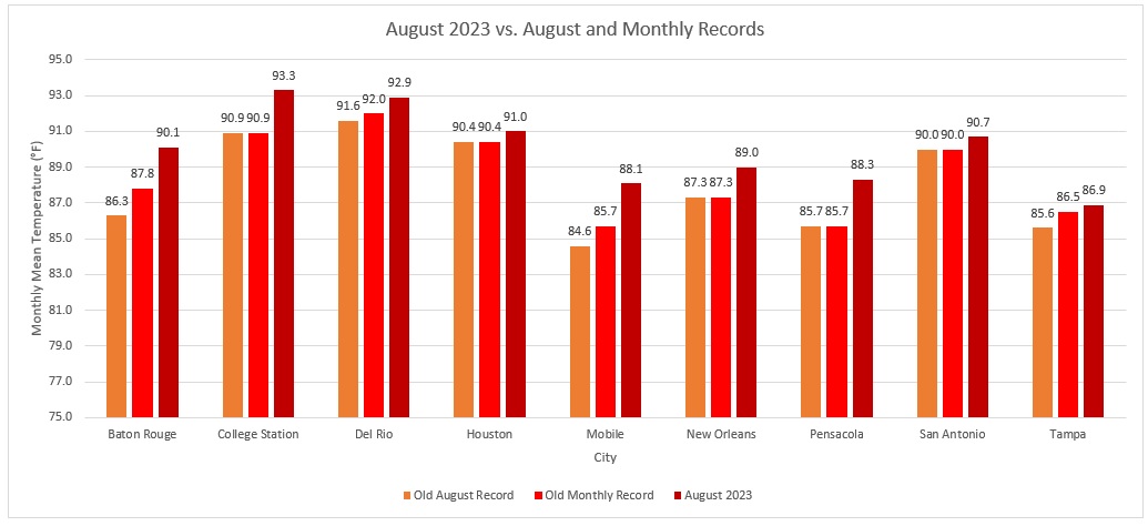
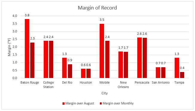
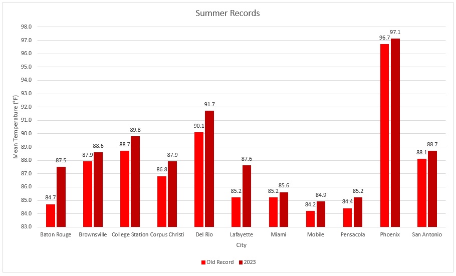
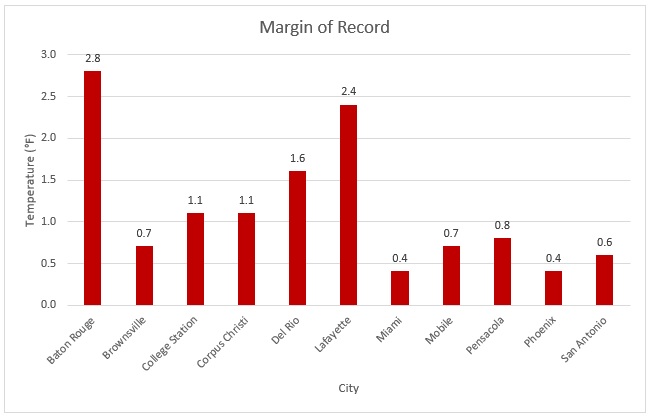
Yes, It was an uncommon event. Predominant patterns were stuck. Parts of the South roasted with their highest monthly and seasonal temperatures on record. Some of the records were annihilated. It was unseasonably cool up here. Select August Records: Select Summer Records:

-
The GFS appears to have an issue where it overstates temperatures on a fairly regular basis during summer. I've read some speculation that the issue concerns soil moisture (overly dry assumption) and then amplifies the heat. I haven't seen anything definitive on the issue, though.
-
A somewhat cooler than normal August is concluding. New York City had a mean temperature of 75.0°, which was 0.9° below normal. After an unseasonably chilly night, tomorrow will be fair and cool. The Labor Day weekend will start cool but turn noticeably warmer. The ECMWF weeklies suggest that the September 4-18 period could see temperatures average above to much above normal across the region. Parts of the region could see high temperatures peak at or above 90° on one or more days. The ENSO Region 1+2 anomaly was +3.1°C and the Region 3.4 anomaly was +1.5°C for the week centered around August 23. For the past six weeks, the ENSO Region 1+2 anomaly has averaged +3.27°C and the ENSO Region 3.4 anomaly has averaged +1.23°C. El Niño conditions will likely continue to strengthen into the fall with the current East-based event transitioning to a basinwide El Niño for the upcoming winter. The SOI was -9.83 today. The preliminary Arctic Oscillation (AO) was -0.007 today. On August 29 the MJO was unavailable. The August 28-adjusted amplitude was 0.986(RMM).
-
DCA _ NYC _ BOS __ ORD _ ATL _ IAH ___ DEN _ PHX _ SEA 2.0 2.1 1.8 3.5 2.0 2.8 2.8 2.0 0.6
-
Sustained unseasonable warmth could develop starting late in the first week of September or just afterward. The ECMWF weeklies suggest that the September 4-18 period could see temperatures average above to much above normal across the region. The ENSO Region 1+2 anomaly was +3.1°C and the Region 3.4 anomaly was +1.5°C for the week centered around August 23. For the past six weeks, the ENSO Region 1+2 anomaly has averaged +3.27°C and the ENSO Region 3.4 anomaly has averaged +1.23°C. El Niño conditions will likely continue to strengthen into the fall with the current East-based event transitioning to a basinwide El Niño for the upcoming winter. The SOI was -24.76 today. The preliminary Arctic Oscillation (AO) was +0.278 today. On August 28 the MJO was in Phase 2 at an amplitude of 0.986 (RMM). The August 27-adjusted amplitude was 1.100 (RMM). Based on sensitivity analysis applied to the latest guidance, there is an implied near 100% probability that New York City will have a cooler than normal August (1991-2020 normal). August will likely finish with a mean temperature near 75.0° (1.1° below normal).
-
Showers and a period of rain are likely tonight into tomorrow. The Thursday and Friday should be cool for the season. Sustained unseasonable warmth could develop starting late in the first week of September or just afterward. Florida's "Big Bend" region will experience a devastating major hurricane landfall. A towering storm 10-foot or greater storm surge will swamp much of Cedar Key and low-lying coastal areas. Winds will likely be Category 3 strength and some possibility still exists for Category 4 winds. The ENSO Region 1+2 anomaly was +3.1°C and the Region 3.4 anomaly was +1.5°C for the week centered around August 23. For the past six weeks, the ENSO Region 1+2 anomaly has averaged +3.27°C and the ENSO Region 3.4 anomaly has averaged +1.23°C. El Niño conditions will likely continue to strengthen into the fall with the current East-based event transitioning to a basinwide El Niño for the upcoming winter. The SOI was -24.76 today. The preliminary Arctic Oscillation (AO) was +0.402 today. On August 27 the MJO was in Phase 2 at an amplitude of 1.107 (RMM). The August 26-adjusted amplitude was 1.142 (RMM). Based on sensitivity analysis applied to the latest guidance, there is an implied near 100% probability that New York City will have a cooler than normal August (1991-2020 normal). August will likely finish with a mean temperature near 75.0° (1.1° below normal).
-
2019 was NYC's last cooler than normal August. August 2023 will be the coolest August since August 2017. Both August 2017 and August 2019 were followed by a warmer than normal September.
-
It's longest 105+ streak was set earlier this year. No pre-2023 streak rivals the two streaks this year.
-
August will close out with cooler than normal readings. Tomorrow could see highs only in the 70s across much of the region. Showers and a period of rain are likely tomorrow night into Wednesday. Out West, Phoenix recorded a 117° high temperature, which tied the August record. Brownsville reached 106°, which tied that city's all-time high. Tomorrow into tomorrow night, Idalia will likely undergo rapid intensification. It could make Florida landfall as a Category 3 or 4 hurricane. In the long-range, it remains more likely than not that ridges will wax and wane over the central and southern U.S., producing more heat in areas that have seen a lot of it this summer. If that idea holds, the Northeast will likely only see some short-lived periods of warmer or much warmer than normal temperatures through at least the first week of September. Some short-lived warmth could arrive late in the first week of September. More sustained unseasonable warmth could develop afterward. The ENSO Region 1+2 anomaly was +3.1°C and the Region 3.4 anomaly was +1.5°C for the week centered around August 23. For the past six weeks, the ENSO Region 1+2 anomaly has averaged +3.27°C and the ENSO Region 3.4 anomaly has averaged +1.23°C. El Niño conditions will likely continue to strengthen into the fall with the current East-based event transitioning to a basinwide El Niño for the upcoming winter. The SOI was -10.99 today. The preliminary Arctic Oscillation (AO) was +0.794 today. On August 26 the MJO was in Phase 1 at an amplitude of 1.148 (RMM). The August 25-adjusted amplitude was 1.180 (RMM). Based on sensitivity analysis applied to the latest guidance, there is an implied near 100% probability that New York City will have a cooler than normal August (1991-2020 normal). August will likely finish with a mean temperature near 74.8° (1.3° below normal).
-
August will close out with cooler than normal readings. Tomorrow and Tuesday could see highs only in the 70s across much of the region. Meanwhile, the U.S. Gulf Region roasted for another day under near all-time and all-time record heat. All-time record temperatures included: Beaumont: 111° Houston: 109° (tied all-time record) New Iberia, LA: 109° Lafayette, LA: 110° Lake Charles: 109° Lufkin, TX: 111° New Orleans: 105° In the long-range, it remains more likely than not that ridges will wax and wane over the central and southern U.S., producing more heat in areas that have seen a lot of it this summer. If that idea holds, the Northeast will likely only see some short-lived periods of warmer or much warmer than normal temperatures through at least the first week or two of September. Some short-lived warmth could arrive late in the first week of September. The ENSO Region 1+2 anomaly was +3.3°C and the Region 3.4 anomaly was +1.3°C for the week centered around August 16. For the past six weeks, the ENSO Region 1+2 anomaly has averaged +3.15°C and the ENSO Region 3.4 anomaly has averaged +1.17°C. El Niño conditions have developed and will likely continue to strengthen through at least the summer. The probability of an East-based El Niño event has increased. The SOI was -10.99 today. The preliminary Arctic Oscillation (AO) was +0.769 today. On August 25 the MJO was in Phase 1 at an amplitude of 1.182 (RMM). The August 24-adjusted amplitude was 1.354 (RMM). Based on sensitivity analysis applied to the latest guidance, there is an implied near 100% probability that New York City will have a cooler than normal August (1991-2020 normal). August will likely finish with a mean temperature near 74.6° (1.5° below normal).
-
Temperatures rose into the middle and even upper 80s across the rgion on what will likely be the warmest day for the remainder of August. Philadelphia topped out at 90°. Meanwhile, along the Gulf Coast, a historic heat dome delivered numerous all-time record highs including: Gulfport, MS: 107° (new all-time record) Mobile: 106° (new all-time record) New Orleans: 102° (tied all-time record) Pascagoula, MS: 106° (new all-time record) Pensacola topped out at 105°, which fell 1° short of its all-time record. Baton Rouge, Houston, New Orleans, and Tampa, among other cities, remain on track for their hottest month on record. A prolonged stretch of generally cooler than normal readings is underway and will continue through at least the end of the month. In the long-range, it remains more likely than not that ridges will wax and wane over the central and southern U.S., producing more heat in areas that have seen a lot of it this summer. If that idea holds, the Northeast will likely only see some short-lived periods of warmer or much warmer than normal temperatures through at least the first week or two of September. The ENSO Region 1+2 anomaly was +3.3°C and the Region 3.4 anomaly was +1.3°C for the week centered around August 16. For the past six weeks, the ENSO Region 1+2 anomaly has averaged +3.15°C and the ENSO Region 3.4 anomaly has averaged +1.17°C. El Niño conditions have developed and will likely continue to strengthen through at least the summer. The probability of an East-based El Niño event has increased. The SOI was -9.77 today. The preliminary Arctic Oscillation (AO) was +0.167 today. On August 24 the MJO was in Phase 1 at an amplitude of 1.401 (RMM). The August 23-adjusted amplitude was 1.668 (RMM). Based on sensitivity analysis applied to the latest guidance, there is an implied 97% probability that New York City will have a cooler than normal August (1991-2020 normal). August will likely finish with a mean temperature near 74.5° (1.6° below normal).
-
Tomorrow will be variably cloudy and warm. A shower or thundershower is possible. Nevertheless, a prolonged stretch of generally cooler than normal readings is underway and will continue through at least the end of the month. In the long-range, it remains more likely than not that ridges will wax and wane over the central and southern U.S., producing more heat in areas that have seen a lot of it this summer. If that idea holds, the Northeast will likely only see some short-lived periods of warmer or much warmer than normal temperatures through at least the first week or two of September. The ENSO Region 1+2 anomaly was +3.3°C and the Region 3.4 anomaly was +1.3°C for the week centered around August 16. For the past six weeks, the ENSO Region 1+2 anomaly has averaged +3.15°C and the ENSO Region 3.4 anomaly has averaged +1.17°C. El Niño conditions have developed and will likely continue to strengthen through at least the summer. The probability of an East-based El Niño event has increased. The SOI was -9.77 today. The preliminary Arctic Oscillation (AO) was -0.355 today. On August 23 the MJO was in Phase 1 at an amplitude of 1.673 (RMM). The August 22-adjusted amplitude was 1.906 (RMM). Based on sensitivity analysis applied to the latest guidance, there is an implied 95% probability that New York City will have a cooler than normal August (1991-2020 normal). August will likely finish with a mean temperature near 74.5° (1.6° below normal).
-
Winter 2023-2024
donsutherland1 replied to Stormchaserchuck1's topic in Weather Forecasting and Discussion
Not yet. It's going to be more complicated this year if the north Atlantic remains as warm as it is. It could distort the pattern evolution. I don't think it will be a general wall-to-wall NAO+/AO+ winter, though. -
Showers and thunderstorms are likely tonight and tomorrow. A prolonged stretch of generally cooler than normal readings will continue through at least the end of the month. Meanwhile, Chicago reached a daily record-tying 100° today. Houston (109°) and Alexandria, LA (110°) tied their all-time records. In Europe, more than 75 cities in France set new all-time high temperature records. In the long-range, it remains more likely than not that ridges will wax and wane over the central and southern U.S., producing more heat in areas that have seen a lot of it this summer. If that idea holds, the Northeast will likely only see some short-lived periods of warmer or much warmer than normal temperatures through at least the first week or two of September. The ENSO Region 1+2 anomaly was +3.3°C and the Region 3.4 anomaly was +1.3°C for the week centered around August 16. For the past six weeks, the ENSO Region 1+2 anomaly has averaged +3.15°C and the ENSO Region 3.4 anomaly has averaged +1.17°C. El Niño conditions have developed and will likely continue to strengthen through at least the summer. The probability of an East-based El Niño event has increased. The SOI was -12.93 today. The preliminary Arctic Oscillation (AO) was -0.742 today. On August 22 the MJO was in Phase 1 at an amplitude of 1.931 (RMM). The August 21-adjusted amplitude was 1.865 (RMM). Based on sensitivity analysis applied to the latest guidance, there is an implied 93% probability that New York City will have a cooler than normal August (1991-2020 normal). August will likely finish with a mean temperature near 74.4° (1.7° below normal).
-
A prolonged stretch of cooler than normal readings will continue through at least the weekend. Showers and thundershowers are likely later tomorrow and tomorrow night. In the long-range, it remains more likely than not that ridges will wax and wane over the central and southern U.S., producing more heat in areas that have seen a lot of it this summer. If that idea holds, the Northeast will likely only see some short-lived periods of warmer or much warmer than normal temperatures through at least the first week or two of September. The ENSO Region 1+2 anomaly was +3.3°C and the Region 3.4 anomaly was +1.3°C for the week centered around August 16. For the past six weeks, the ENSO Region 1+2 anomaly has averaged +3.15°C and the ENSO Region 3.4 anomaly has averaged +1.17°C. El Niño conditions have developed and will likely continue to strengthen through at least the summer. The probability of an East-based El Niño event has increased. The SOI was -17.48 today. The preliminary Arctic Oscillation (AO) was -0.573 today. On August 21 the MJO was in Phase 1 at an amplitude of 1.871 (RMM). The August 20-adjusted amplitude was 1.751 (RMM). Based on sensitivity analysis applied to the latest guidance, there is an implied 86% probability that New York City will have a cooler than normal August (1991-2020 normal). August will likely finish with a mean temperature near 74.6° (1.5° below normal).
-
A prolonged stretch of cooler than normal readings will continue through at least the weekend. In the long-range, it remains more likely than not that ridges will wax and wane over the central and southern U.S., producing more heat in areas that have seen a lot of it this summer. If that idea holds, the Northeast will likely only see some short-lived periods of warmer or much warmer than normal temperatures through at least the first week or two of September. The ENSO Region 1+2 anomaly was +3.3°C and the Region 3.4 anomaly was +1.3°C for the week centered around August 16. For the past six weeks, the ENSO Region 1+2 anomaly has averaged +3.15°C and the ENSO Region 3.4 anomaly has averaged +1.17°C. El Niño conditions have developed and will likely continue to strengthen through at least the summer. The probability of an East-based El Niño event has increased. The SOI was -14.02 today. The preliminary Arctic Oscillation (AO) was -0.452 today. On August 20 the MJO was in Phase 1 at an amplitude of 1.747 (RMM). The August 19-adjusted amplitude was 1.560 (RMM). Based on sensitivity analysis applied to the latest guidance, there is an implied 83% probability that New York City will have a cooler than normal August (1991-2020 normal). August will likely finish with a mean temperature near 74.6° (1.5° below normal).
-
Cooler air will return for tomorrow. Afterward, a prolonged stretch of cooler than normal readings will continue through at least the weekend. Yesterday, Hilary brought an all-time daily record 2.20" rainfall to Death Valley. That tops the previous one- two- and three-day records. It also matches that location's average annual rainfall (1991-2020 baseline) The ENSO Region 1+2 anomaly was +3.3°C and the Region 3.4 anomaly was +1.3°C for the week centered around August 16. For the past six weeks, the ENSO Region 1+2 anomaly has averaged +3.15°C and the ENSO Region 3.4 anomaly has averaged +1.17°C. El Niño conditions have developed and will likely continue to strengthen through at least the summer. The probability of an East-based El Niño event has increased. The SOI was unavailable today. The preliminary Arctic Oscillation (AO) was -0.500 today. On August 19 the MJO was in Phase 1 at an amplitude of 1.553 (RMM). The August 18-adjusted amplitude was 1.295 (RMM). Based on sensitivity analysis applied to the latest guidance, there is an implied 82% probability that New York City will have a cooler than normal August (1991-2020 normal). August will likely finish with a mean temperature near 74.7° (1.4° below normal).
-
Tomorrow will be unseasonably warm before cooler air returns. Parts of the region could see the temperature reach or exceed 90°. Hilary continues to bring excessive rainfall to the California desert into Nevada. 8 WSW Borrego Spring in San Diego County has seen 6.02" of rain. Daily rainfall records include: Burbank: 1.44" Long Beach: 1.49" Los Angeles: 1.25" Los Angeles (downtown): 1.50" Palm Springs: 2.64" ***new August daily record*** Palmdale: 2.66" ***new August daily record*** San Diego: 0.91" Earlier today, Yuma, Arizona recorded 45 mph sustained winds with gusts to 69 mph. The wind gusted as high as 84 mph in California's mountains. The adjacent heat dome produced impressive record heat. Houston topped out at 108° (2nd highest temperature on record) and College Station hit an all-time record-tying 112°. The ENSO Region 1+2 anomaly was +3.3°C and the Region 3.4 anomaly was +1.2°C for the week centered around August 9. For the past six weeks, the ENSO Region 1+2 anomaly has averaged +3.32°C and the ENSO Region 3.4 anomaly has averaged +1.12°C. El Niño conditions have developed and will likely continue to strengthen through at least the summer. The probability of an East-based El Niño event has increased. The SOI was unavailable today. The preliminary Arctic Oscillation (AO) was -1.066 today. On August 18 the MJO was in Phase 1 at an amplitude of 1.255 (RMM). The August 17-adjusted amplitude was 1.120 (RMM). Based on sensitivity analysis applied to the latest guidance, there is an implied 77% probability that New York City will have a cooler than normal August (1991-2020 normal). August will likely finish with a mean temperature near 74.8° (1.3° below normal).
-
Warmer air will return to close the weekend. Monday will be unseasonably warm before cooler air returns. Parts of the region could see the temperature reach or exceed 90°. Meanwhile Hilary remains on track to bring a historic rainfall to parts of the California desert into Nevada tonight through Monday. Highest rainfall amounts could reach 6"-10". It is possible that Death Valley's storm total rainfall could exceed its highest monthly total. The ENSO Region 1+2 anomaly was +3.3°C and the Region 3.4 anomaly was +1.2°C for the week centered around August 9. For the past six weeks, the ENSO Region 1+2 anomaly has averaged +3.32°C and the ENSO Region 3.4 anomaly has averaged +1.12°C. El Niño conditions have developed and will likely continue to strengthen through at least the summer. The probability of an East-based El Niño event has increased. The SOI was unavailable today. The preliminary Arctic Oscillation (AO) was -1.511 today. On August 17 the MJO was in Phase 8 at an amplitude of 1.117 (RMM). The August 16-adjusted amplitude was 1.089 (RMM). Based on sensitivity analysis applied to the latest guidance, there is an implied 72% probability that New York City will have a cooler than normal August (1991-2020 normal). August will likely finish with a mean temperature near 75.0° (1.1° below normal).