

donsutherland1
-
Posts
24,194 -
Joined
Content Type
Profiles
Blogs
Forums
American Weather
Media Demo
Store
Gallery
Everything posted by donsutherland1
-
A real tragedy. May she RIP.
-
The Bay Shore figure came from the NWS's local storm report.
-
Parts of the region saw excessive rainfall that produced flash flooding. Bay Shore picked up 6.15" of rain. Rainfall amounts through 4 pm included: Bridgeport: 1.45" (old record: 0.93", 1984) Hartford: 1.53" (old record: 1.33", 1910) Islip: 4.63" (old record: 1.22", 1989) ***Hourly rainfall of 3.04" was the 2nd highest on record and a once-in-100-year event*** Manchester: 2.44" (old record: 1.30", 1961) New York City-La Guardia Airport: 1.38" (old record: 1.19", 1947) Newark: 1.48" (old record: 1.22", 1933) Providence: 2.08" (old record: 0.85", 1910) In the wake of the heavy rainfall, a dry but very warm day lies ahead to start the work week. Readings will approach to top 90° in many locations across the region. An extreme heat event continues to grip the Southwest. Cities such as Las Vegas, Phoenix, and Tucson could see readings continue to rise toward or above their record daily levels over the next few days. The ENSO Region 1+2 anomaly was +3.3°C and the Region 3.4 anomaly was +1.0°C for the week centered around July 5. For the past six weeks, the ENSO Region 1+2 anomaly has averaged +2.78°C and the ENSO Region 3.4 anomaly has averaged +0.92°C. El Niño conditions have developed and will likely continue to strengthen through at least the summer. The probability of an East-based El Niño event has increased. The SOI was -1.97 today. The preliminary Arctic Oscillation (AO) was +0.035 today. On July 14 the MJO was in Phase 2 at an amplitude of 0.573 (RMM). The July 13-adjusted amplitude was 0.796 (RMM). Based on sensitivity analysis applied to the latest guidance, there is an implied 72% probability that New York City will have a warmer than normal July (1991-2020 normal). July will likely finish with a mean temperature near 79.2° (1.7° above normal).
-
Islip has received 4.57” of rain so far. That smashed the daily record of 1.22” from 1989. The preliminary hourly amount of 3.04” would be Islip’s second highest hourly figure on record.
-
Heavy thunderstorms are likely tonight into tomorrow. Excessive rainfall that could produce flooding is likely in parts of the region. An extreme heat event grips the Southwest. Cities such as Las Vegas, Phoenix, and Tucson could see readings continue to rise toward or above their record daily levels. Las Vegas could challenge its monthly and all-time record. Death Valley could approach or reach 130°, which is the highest temperature ever reliably recorded. The excessive heat could extend across parts of California, Nevada, New Mexico and a large part of Texas. Select highs today: Blythe, CA: 118° (old record: 117°, 1998 and 2006) El Centro, CA: 116° (tied record set in 2019) Kingman, AZ: 114° (old record: 110°, 1911) ***New all-time record*** Needles, CA: 121° (tied record set in 2006) The ENSO Region 1+2 anomaly was +3.3°C and the Region 3.4 anomaly was +1.0°C for the week centered around July 5. For the past six weeks, the ENSO Region 1+2 anomaly has averaged +2.78°C and the ENSO Region 3.4 anomaly has averaged +0.92°C. El Niño conditions have developed and will likely continue to strengthen through at least the summer. The probability of an East-based El Niño event has increased. The SOI was -2.28 today. The preliminary Arctic Oscillation (AO) was -0.645 today. On July 13 the MJO was in Phase 2 at an amplitude of 0.817 (RMM). The July 12-adjusted amplitude was 0.990 (RMM). Based on sensitivity analysis applied to the latest guidance, there is an implied 72% probability that New York City will have a warmer than normal July (1991-2020 normal). July will likely finish with a mean temperature near 79.2° (1.7° above normal).
-
A warm and humid weekend is likely. Additional rain is likely Saturday night and Sunday. The potential exists for excessive rainfall that could produce flooding. An extreme heat event is underway in the Southwest. As of 4 pm, MST, Phoenix has reached 116° today. That tied the daily record which had been set in 2003. Cities such as Las Vegas, Phoenix, and Tucson could see readings rise toward record daily levels. Las Vegas could challenge its monthly and all-time record. Death Valley could approach or reach 130°, which is the highest temperature ever reliably recorded. The excessive heat could extend across parts of California, Nevada, New Mexico and a large part of Texas. The ENSO Region 1+2 anomaly was +3.3°C and the Region 3.4 anomaly was +1.0°C for the week centered around July 5. For the past six weeks, the ENSO Region 1+2 anomaly has averaged +2.78°C and the ENSO Region 3.4 anomaly has averaged +0.92°C. El Niño conditions have developed and will likely continue to strengthen through at least the summer. The probability of an East-based El Niño event has increased. The SOI was -1.60 today. The preliminary Arctic Oscillation (AO) was -0.707 today. On July 12 the MJO was in Phase 2 at an amplitude of 0.987 (RMM). The July 11-adjusted amplitude was 0.941 (RMM). Based on sensitivity analysis applied to the latest guidance, there is an implied 74% probability that New York City will have a warmer than normal July (1991-2020 normal). July will likely finish with a mean temperature near 79.3° (1.8° above normal).
-
Tomorrow could be briefly cooler due to widespread showers and thunderstorms. Areas that saw flooding from the recent heavy rainfall could be at risk of additional flooding. The risk is particularly high in Vermont overnight into tomorrow. A warm and humid weekend is likely. Additional rain is likely Saturday night and Sunday. An extreme heat event is underway in the Southwest. Cities such as Las Vegas, Phoenix, and Tucson could see readings rise toward record daily levels. Las Vegas could challenge its monthly and all-time record. Death Valley could approach or reach 130°, which is the highest temperature ever reliably recorded. The excessive heat could extend across parts of California, Nevada, New Mexico and a large part of Texas. Meanwhile, Marathon, FL saw the mercury top out at 99° today. That tied the all-time record. The ENSO Region 1+2 anomaly was +3.3°C and the Region 3.4 anomaly was +1.0°C for the week centered around July 5. For the past six weeks, the ENSO Region 1+2 anomaly has averaged +2.78°C and the ENSO Region 3.4 anomaly has averaged +0.92°C. El Niño conditions have developed and will likely continue to strengthen through at least the summer. The probability of an East-based El Niño event has increased. The SOI was +4.31 today. The preliminary Arctic Oscillation (AO) was -0.747 today. On July 11 the MJO was in Phase 2 at an amplitude of 0.907 (RMM). The July 10-adjusted amplitude was 1.018 (RMM). Based on sensitivity analysis applied to the latest guidance, there is an implied 73% probability that New York City will have a warmer than normal July (1991-2020 normal). July will likely finish with a mean temperature near 79.2° (1.7° above normal).
-
The very warm weather will continue through tomorrow. Friday could be briefly cooler due to widespread showers and thunderstorms. Areas that saw flooding from the recent heavy rainfall could be at risk of additional flooding. A warm and humid weekend is likely. An extreme heat event is now developing in the Southwest. Cities such as Las Vegas, Phoenix, and Tucson could see readings rise toward record daily levels. Las Vegas could challenge is monthly and all-time record. Death Valley could approach or reach 130°, which is the highest temperature ever reliably recorded. The excessive heat could extend across parts of California, Nevada, New Mexico and a large part of Texas. The ENSO Region 1+2 anomaly was +3.3°C and the Region 3.4 anomaly was +1.0°C for the week centered around July 5. For the past six weeks, the ENSO Region 1+2 anomaly has averaged +2.78°C and the ENSO Region 3.4 anomaly has averaged +0.92°C. El Niño conditions have developed and will likely continue to strengthen through at least the summer. The probability of an East-based El Niño event has increased. The SOI was +5.23 today. The preliminary Arctic Oscillation (AO) was -0.558 today. On July 10 the MJO was in Phase 2 at an amplitude of 1.020 (RMM). The July 9-adjusted amplitude was 1.244 (RMM). Based on sensitivity analysis applied to the latest guidance, there is an implied 71% probability that New York City will have a warmer than normal July (1991-2020 normal). July will likely finish with a mean temperature near 79.2° (1.7° above normal).
-
Yes. NWS Phoenix has noted the combination of climate change and the UHI. Phoenix continues to grow rapidly, despite water issues and rising heat.
-
Yes. It's probably premature to have a confident idea about the VP from this forecasting range.
-
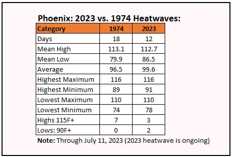
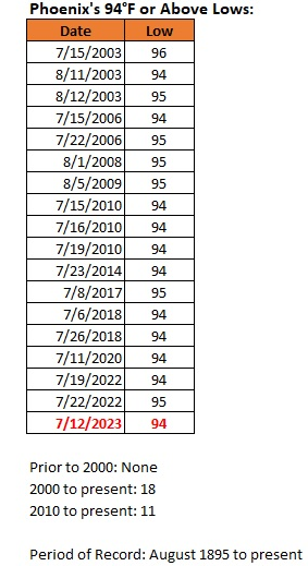
With growing prospects that the ongoing heatwave in parts of the Southwest could be among the region's worst in history, a handful of social media accounts have been loudly and increasingly frantically trying to dismiss and discount the severity of the heatwave. Claims that a 1974 heatwave, currently Phoenix's longest on record (18 consecutive days), was more severe have been made. The ongoing heatwave could eclipse it in duration and already exceeds it in the intensity of the heat (3.1° warmer so far). The most severe heat still lies ahead, as Phoenix will experience an extreme heat event (Clarke et al., 2014 methodology). Such accounts are not credible sources of meteorological or climate information, especially as those in the affected region who are inclined to accept their false narrative could put themselves at unnecessary risk. NWS Phoenix, Accuweather, and other private sources have been doing their utmost to warn residents of the heat-related risks. Yet, some accounts are trying to distract and confuse local residents. On account of the absurd social media claims, here's how the current heatwave and the 1974 heatwave compare: Today saw a low temperature of 94° in Phoenix (not factored in above), which surpassed the record of 93° that was set in 2020 and tied in 2022. Since Phoenix's records were kept beginning in August 1895, Phoenix has had 18 low temperatures of 94° or above. All of those low temperatures have occurred since 2003. Las Vegas, Salt Lake City, and even Death Valley, could experience extreme heat events from the current heatwave. For the first time, Del Rio and Laredo could experience simultaneous extreme heat events with Las Vegas, Salt Lake City, Phoenix, and Death Valley, which illustrates the expansive area of extreme heat.
-
Yes. That's my thinking, too. It is well-supported by the ENSO guidance, too.
-
ENSO Region 1+2 has an anomaly > 3°C. The last time that happened was during the 1997-98 super El Niño event. A basinwide or east-based El Niño appears far more likely than a Modoki one.
-
The very warm weather will continue through Thursday. Friday could be briefly cooler due to widespread showers and thunderstorms. A warm and humid weekend is likely. An extreme heat event will likely develop in the Southwest later this week. Cities such as Tucson and Phoenix could see readings rise toward record daily levels. The excessive heat could extend across parts of California, Nevada, New Mexico and a large part of Texas. The ENSO Region 1+2 anomaly was +3.3°C and the Region 3.4 anomaly was +1.0°C for the week centered around July 5. For the past six weeks, the ENSO Region 1+2 anomaly has averaged +2.78°C and the ENSO Region 3.4 anomaly has averaged +0.92°C. El Niño conditions have developed and will likely continue to strengthen through at least the summer. The probability of an East-based El Niño event has increased. The SOI was +3.45 today. The preliminary Arctic Oscillation (AO) was -0.763 today. On July 9 the MJO was in Phase 2 at an amplitude of 1.253 (RMM). The July 8-adjusted amplitude was 1.204 (RMM). Based on sensitivity analysis applied to the latest guidance, there is an implied 71% probability that New York City will have a warmer than normal July (1991-2020 normal). July will likely finish with a mean temperature near 79.2° (1.7° above normal).
-
Extreme rainfall will bring additional flooding to parts of Vermont tonight. The New York City and Philadelphia regions will enjoy a quiet but warm night. More very warm and perhaps hot weather will develop starting tomorrow. Friday could be briefly cooler due to widespread showers and thunderstorms. An extreme heat event will likely develop in the Southwest later this week even as Phoenix has seen its hottest first 10 days of July (100.0° vs. the 2017 record of 99.4°). Cities such as Tucson and Phoenix could see readings rise toward record daily levels. The excessive heat could extend across New Mexico and a large part of Texas. The ENSO Region 1+2 anomaly was +3.3°C and the Region 3.4 anomaly was +1.0°C for the week centered around July 5. For the past six weeks, the ENSO Region 1+2 anomaly has averaged +2.78°C and the ENSO Region 3.4 anomaly has averaged +0.92°C. El Niño conditions have developed and will likely continue to strengthen through at least the summer. The probability of an East-based El Niño event has increased. The SOI was +9.29 today. The preliminary Arctic Oscillation (AO) was -1.326 today. On July 8 the MJO was in Phase 2 at an amplitude of 1.311 (RMM). The July 7-adjusted amplitude was 1.505 (RMM). Based on sensitivity analysis applied to the latest guidance, there is an implied 67% probability that New York City will have a warmer than normal July (1991-2020 normal). July will likely finish with a mean temperature near 79.0° (1.5° above normal).
-
Tonight and tomorrow will feature rounds of heavy showers and thundershowers. Flooding is possible in some locations. More very warm and perhaps hot weather could develop later in the week. An extreme heat event could develop in the Southwest. Cities such as Tucson and Phoenix could see readings rise toward record daily levels. The excessive heat could extend across New Mexico and a large part of Texas. The ENSO Region 1+2 anomaly was +2.9°C and the Region 3.4 anomaly was +0.9°C for the week centered around June 28. For the past six weeks, the ENSO Region 1+2 anomaly has averaged +2.57°C and the ENSO Region 3.4 anomaly has averaged +0.82°C. El Niño conditions have developed and will likely continue to strengthen through at least the summer. The SOI was +4.31 today. The preliminary Arctic Oscillation (AO) was -1.344 today. On July 7 the MJO was in Phase 2 at an amplitude of 1.522 (RMM). The July 6-adjusted amplitude was 1.636 (RMM). Based on sensitivity analysis applied to the latest guidance, there is an implied 67% probability that New York City will have a warmer than normal July (1991-2020 normal). July will likely finish with a mean temperature near 79.0° (1.5° above normal).
-
It will turn somewhat cooler tomorrow with additional potentially heavy showers and thunderstorms. More very warm and perhaps hot weather could develop next week. Next week could also see an extreme heat event develop in the Southwest. Cities such as Tucson and Phoenix could see readings rise toward record daily levels. The excessive heat could extend across New Mexico and a large part of Texas. The ENSO Region 1+2 anomaly was +2.9°C and the Region 3.4 anomaly was +0.9°C for the week centered around June 28. For the past six weeks, the ENSO Region 1+2 anomaly has averaged +2.57°C and the ENSO Region 3.4 anomaly has averaged +0.82°C. El Niño conditions have developed and will likely continue to strengthen through at least the summer. The SOI was +9.79 today. The preliminary Arctic Oscillation (AO) was -0.873 today. On July 6 the MJO was in Phase 2 at an amplitude of 1.634 (RMM). The July 5-adjusted amplitude was 1.867 (RMM). Based on sensitivity analysis applied to the latest guidance, there is an implied 67% probability that New York City will have a warmer than normal July (1991-2020 normal). July will likely finish with a mean temperature near 79.0° (1.5° above normal).
-
It will be steamy and very warm through the end of the week. Temperatures could continue to reach or exceed 90° in parts of the region. Afterward, it will turn somewhat cooler on Sunday with potentially heavy showers and thunderstorms. More very warm and perhaps hot weather could develop next week. Next week could also see an extreme heat event develop in the Southwest. Cities such as Tucson and Phoenix could see readings rise toward record daily levels. The excessive heat could extend across New Mexico and a large part of Texas. The ENSO Region 1+2 anomaly was +2.9°C and the Region 3.4 anomaly was +0.9°C for the week centered around June 28. For the past six weeks, the ENSO Region 1+2 anomaly has averaged +2.57°C and the ENSO Region 3.4 anomaly has averaged +0.82°C. El Niño conditions have developed and will likely continue to strengthen through at least the summer. The SOI was +14.34 today. The preliminary Arctic Oscillation (AO) was -0.681 today. On July 5 the MJO was in Phase 2 at an amplitude of 1.871 (RMM). The July 4-adjusted amplitude was 1.643 (RMM). Based on sensitivity analysis applied to the latest guidance, there is an implied 62 probability that New York City will have a warmer than normal July (1991-2020 normal). July will likely finish with a mean temperature near 78.8° (1.3° above normal).
-
The temperature again soared into the lower 90s across parts of the region. The heat extended into Maine where Bangor reached 92° and Caribou reached a record-tying 91°. It will be steamy and very warm through the end of the week. Temperatures could continue to reach or exceed 90° in parts of the region. Afterward, near to somewhat above normal readings will likely prevail through mid-month. Next week could also see an extreme heat event develop in the Southwest. Cities such as Tucson and Phoenix could see readings rise toward record daily levels. The excessive heat could extend across New Mexico and a large part of Texas. The ENSO Region 1+2 anomaly was +2.9°C and the Region 3.4 anomaly was +0.9°C for the week centered around June 28. For the past six weeks, the ENSO Region 1+2 anomaly has averaged +2.57°C and the ENSO Region 3.4 anomaly has averaged +0.82°C. El Niño conditions have developed and will likely continue to strengthen through at least the summer. The SOI was +16.68 today. The preliminary Arctic Oscillation (AO) was -0.528 today. On July 4 the MJO was in Phase 2 at an amplitude of 1.642 (RMM). The July 3-adjusted amplitude was 1.607 (RMM).
-
Temperatures surged into the 90s across many parts of the region. Highs included: New York City: 93°, Newark: 94°, and Philadelphia: 93°. Another very warm day lies ahead for tomorrow. It will be steamy and very warm through the end of the week. Temperatures could reach or exceed 90° in parts of the region. Afterward, near to somewhat above normal readings will likely prevail through mid-month. The ENSO Region 1+2 anomaly was +2.9°C and the Region 3.4 anomaly was +0.9°C for the week centered around June 28. For the past six weeks, the ENSO Region 1+2 anomaly has averaged +2.57°C and the ENSO Region 3.4 anomaly has averaged +0.82°C. El Niño conditions have developed and will likely continue to strengthen through at least the summer. The SOI was +12.99 today. The preliminary Arctic Oscillation (AO) was -0.415 today. On July 3 the MJO was in Phase 2 at an amplitude of 1.603 (RMM). The July 2-adjusted amplitude was 1.687 (RMM).
-
Probably a combination of the frontal location and stochastic processes. Convection remains challenging to forecast with often large differences among the models and also outcomes.
-
We didn’t get the worst of the smoke, as the wind directed it elsewhere. On June 7, the wind brought the thickest smoke to the NYC area and then Philadelphia and Washington the following day.
-
Heavier showers and thundershowers drenched parts of the region today. Parts of Connecticut experienced flash flooding. Newark set a new daily rainfall record with 1.19" (old record: 1.07", 1952). Mammatus clouds moved across the sky in New York City and nearby regions. It will be steamy and very warm through the end of the week. Temperatures could reach or exceed 90° in parts of the region. Afterward, near to somewhat above normal readings will likely prevail through mid-month. The ENSO Region 1+2 anomaly was +2.9°C and the Region 3.4 anomaly was +0.9°C for the week centered around June 28. For the past six weeks, the ENSO Region 1+2 anomaly has averaged +2.57°C and the ENSO Region 3.4 anomaly has averaged +0.82°C. El Niño conditions have developed and will likely continue to strengthen through at least the summer. The SOI was +9.29 today. The preliminary Arctic Oscillation (AO) was -0.519 today. On July 2 the MJO was in Phase 2 at an amplitude of 1.687 (RMM). The July 1-adjusted amplitude was 1.614 (RMM).
-
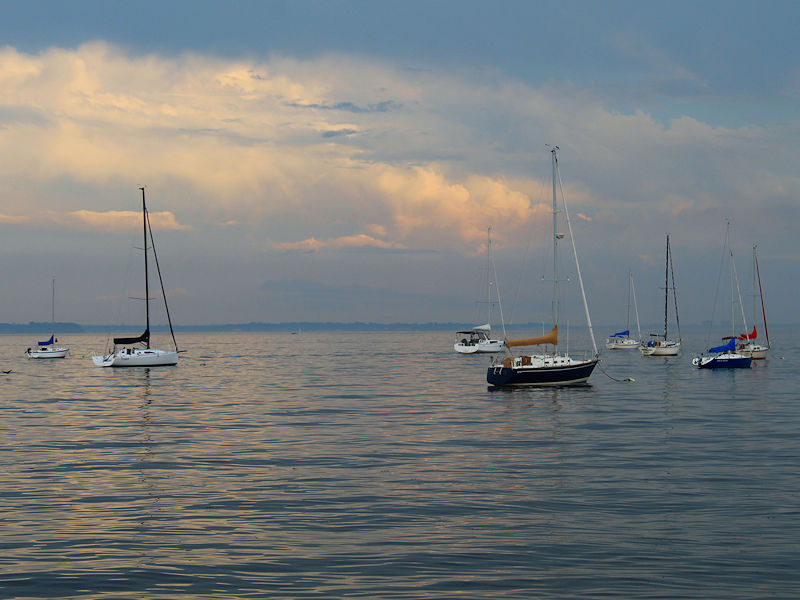
Two photos following earlier thundershowers and downpours.

-
And still the world remains largely on autopilot with fossil fuel production expanding even as renewables expand. The former needs to be phased out, and increasingly rapidly, to offset the consequences of delay and hold the global temperature increase to 1.5°C above the pre-industrial level.


