

donsutherland1
-
Posts
24,194 -
Joined
Content Type
Profiles
Blogs
Forums
American Weather
Media Demo
Store
Gallery
Everything posted by donsutherland1
-
Tomorrow will be even warmer than today. Readings will soar well into the 60s across the region. Overall, the first week of April will likely turn out warmer than normal. As has been the case throughout the winter and early part of spring, the coldest air will remain confined largely to western and central North America. Some of the guidance brings a brief shot of the cooler air into the East for the second week of April, but the EPS weeklies have backed off on the cold. Historic experience with very low snowfall totals through February argues that a very snowy March or big snowstorm during March or April are unlikely. There were 16 winters that had less than 8" of snowfall through February in New York City. Just two (13%) had a 6" or greater snowstorm during March or April: 1889-1890: 6.0" on March 19th and 1991-1992: 6.2" on March 19th. With just 2.3" snowfall through March 19, New York City is now extremely likely to finish the season with less than 10" of snow. Since 1869-70, all 10 winters with less than 8.5" of snow through March 19th wound up with less than 10" of seasonal snowfall. New York City is currently on a path that could culminate in its setting a new record for lowest seasonal snowfall. The ENSO Region 1+2 anomaly was +2.0°C and the Region 3.4 anomaly was 0.0°C for the week centered around March 29. For the past six weeks, the ENSO Region 1+2 anomaly has averaged +1.38°C and the ENSO Region 3.4 anomaly has averaged -0.08°C. Neutral ENSO conditions will likely prevail through at least mid-spring. The SOI was -7.57 today. The preliminary Arctic Oscillation (AO) was -0.659 today. On April 1 the MJO was in Phase 5 at an amplitude of 0.706 (RMM). The March 31-adjusted amplitude was 0.452 (RMM).
-
This morning's chill will be short-lived. Temperatures will turn much milder tomorrow. Overall, the first week of April will likely turn out warmer than normal. As has been the case throughout the winter and early part of spring, the coldest air will remain confined largely to western and central North America. Some of the guidance now brings the cooler air into the East for the second week of April, but uncertainty still exists. Historic experience with very low snowfall totals through February argues that a very snowy March or big snowstorm during March or April are unlikely. There were 16 winters that had less than 8" of snowfall through February in New York City. Just two (13%) had a 6" or greater snowstorm during March or April: 1889-1890: 6.0" on March 19th and 1991-1992: 6.2" on March 19th. With just 2.3" snowfall through March 19, New York City is now extremely likely to finish the season with less than 10" of snow. Since 1869-70, all 10 winters with less than 8.5" of snow through March 19th wound up with less than 10" of seasonal snowfall. New York City is currently on a path that could culminate in its setting a new record for lowest seasonal snowfall. The ENSO Region 1+2 anomaly was +2.0°C and the Region 3.4 anomaly was 0.0°C for the week centered around March 22. For the past six weeks, the ENSO Region 1+2 anomaly has averaged +1.20°C and the ENSO Region 3.4 anomaly has averaged -0.17°C. Neutral ENSO conditions will likely prevail through at least mid-spring. The SOI was -13.56 today. The preliminary Arctic Oscillation (AO) was -0.225 today. On March 31 the MJO was in Phase 5 at an amplitude of 0.437 (RMM). The March 30-adjusted amplitude was 0.502 (RMM).
-
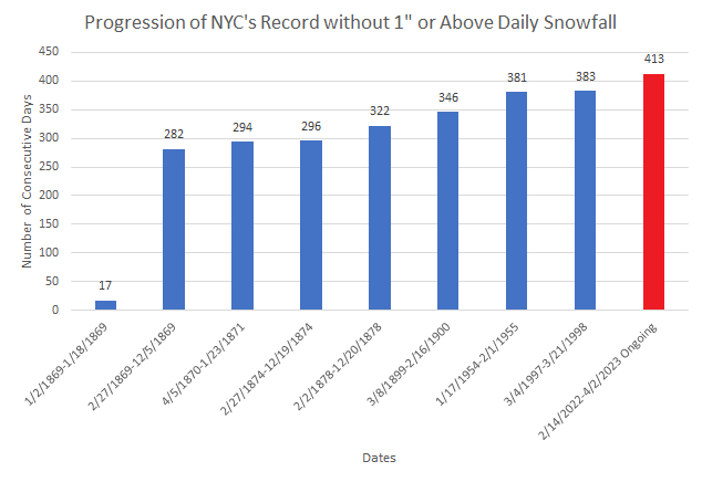
New York City has now surpassed its prior mark for most consecutive days without 1" or more snowfall by 30 days. That margin will very likely swell over coming months, as it appears no such snowfall is likely through the remainder of the 2022-2023 snow season.
-
Clouds gave way to brilliant sunshine this afternoon. In response, the mercury rose into the lower 70s in many parts of the region. However, coastal areas remained locked in the upper 50s and lower 60s on account of a sea breeze. A strong cold front will plow across this evening. The frontal passage could touch off some strong to perhaps severe thunderstorms. Beyond the front, noticeably cooler but not exceptionally cold air will overspread the region. The chill will be short-lived. Overall, the first week of April will likely turn out warmer than normal. As has been the case throughout the winter and early part of spring, the coldest air will remain confined largely to western and central North America. Some of the guidance now brings the cooler air into the East for the second week of April, but considerable uncertainty exists. In terms of the month as a whole, it is somewhat more likely than not that April will wind up on the warm side of normal. Historic experience with very low snowfall totals through February argues that a very snowy March or big snowstorm during March or April are unlikely. There were 16 winters that had less than 8" of snowfall through February in New York City. Just two (13%) had a 6" or greater snowstorm during March or April: 1889-1890: 6.0" on March 19th and 1991-1992: 6.2" on March 19th. With just 2.3" snowfall through March 19, New York City is now extremely likely to finish the season with less than 10" of snow. Since 1869-70, all 10 winters with less than 8.5" of snow through March 19th wound up with less than 10" of seasonal snowfall. New York City is currently on a path that could culminate in its setting a new record for lowest seasonal snowfall. The ENSO Region 1+2 anomaly was +2.0°C and the Region 3.4 anomaly was 0.0°C for the week centered around March 22. For the past six weeks, the ENSO Region 1+2 anomaly has averaged +1.20°C and the ENSO Region 3.4 anomaly has averaged -0.17°C. Neutral ENSO conditions will likely prevail through at least mid-spring. The SOI was -13.56 today. The preliminary Arctic Oscillation (AO) was +0.474 today. On March 30 the MJO was in Phase 3 at an amplitude of 0.502 (RMM). The March 29-adjusted amplitude was 0.573 (RMM).
-
I suspect that the new construction has some microscale impacts.
-
The sun has now come out in Harrisburg. As the warm front continues to push through, rain and clouds should give way to a period of partly to mostly sunny and warm conditions this afternoon.
-
The UHI footprint is mature. The land is warming faster than the ocean. Thus such recent differences may not be too surprising.
-
Morning thoughts… Rain will give way to some sunshine. It will be windy and warm. Strong to severe thunderstorms are possible late in the day or during the evening. High temperatures will reach the upper 60s and lower 70s in most of the region. Likely high temperatures around the region include: New York City (Central Park): 70° Newark: 72° Philadelphia: 73° It will turn much cooler overnight into tomorrow, but temperatures will rapidly rebound early next week. Normals: New York City: 30-Year: 55.8°; 15-Year: 56.3° Newark: 30-Year: 56.6°; 15-Year: 57.4° Philadelphia: 30-Year: 58.8°; 15-Year: 59.5°
-
There was no snowcover on February 11, 1966. The largest difference when the temperature was 32° or below at JFK was 12°: January 21, 2018: JFK: 30°; NYC: 42° February 5, 2019: JFK: 32°; NYC: 44° February 9, 2023: JFK: 30°; NYC: 42°
-
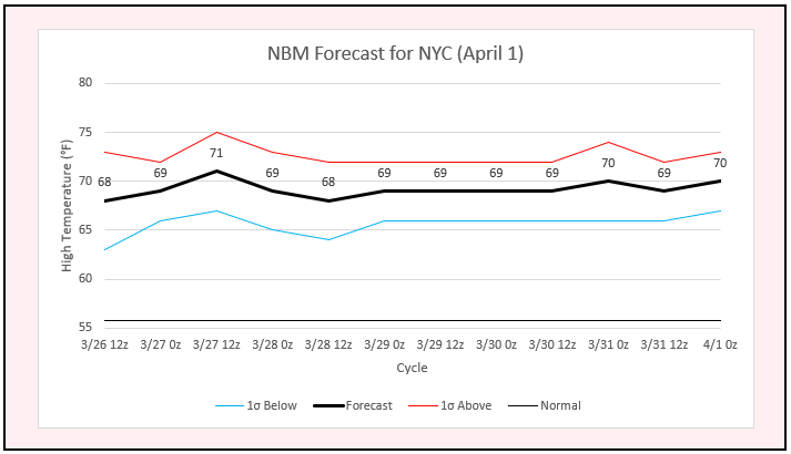
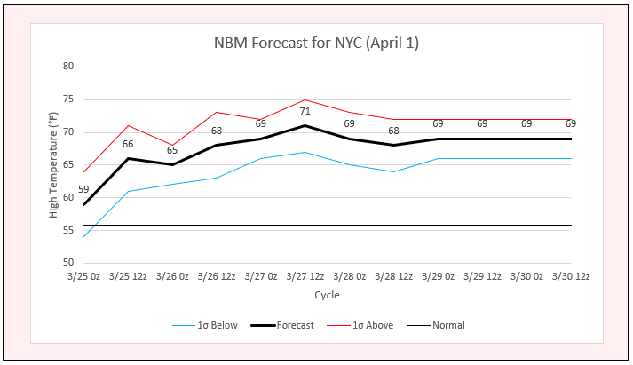
Final 4/1 NBM forecast for NYC: 70°
-
Tomorrow will likely start April off on a much warmer than normal note as showers give way to some sunshine. Another cold front could bring potentially damaging thunderstorms to the region late in the day. Highs will top out in the upper 60s and lower 70s in the northern Mid-Atlantic region. Overall, the first week of April will likely turn out warmer than normal. As has been the case throughout the winter and early part of spring, the coldest air will remain confined largely to western and central North America. Some of the guidance now brings the cooler air into the East for the second week of April, but considerable uncertainty exists. In terms of the month as a whole, it is somewhat more likely than not that April will wind up on the warm side of normal. Historic experience with very low snowfall totals through February argues that a very snowy March or big snowstorm during March or April are unlikely. There were 16 winters that had less than 8" of snowfall through February in New York City. Just two (13%) had a 6" or greater snowstorm during March or April: 1889-1890: 6.0" on March 19th and 1991-1992: 6.2" on March 19th. With just 2.3" snowfall through March 19, New York City is now extremely likely to finish the season with less than 10" of snow. Since 1869-70, all 10 winters with less than 8.5" of snow through March 19th wound up with less than 10" of seasonal snowfall. New York City is currently on a path that could culminate in its setting a new record for lowest seasonal snowfall. The ENSO Region 1+2 anomaly was +2.0°C and the Region 3.4 anomaly was 0.0°C for the week centered around March 22. For the past six weeks, the ENSO Region 1+2 anomaly has averaged +1.20°C and the ENSO Region 3.4 anomaly has averaged -0.17°C. Neutral ENSO conditions will likely prevail through at least mid-spring. The SOI was -4.02 today. The preliminary Arctic Oscillation (AO) was +1.227 today. On March 29 the MJO was in Phase 3 at an amplitude of 0.574 (RMM). The March 28-adjusted amplitude was 1.030 (RMM).
-
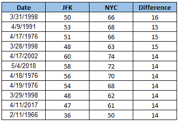
The largest gaps in low temperatures between JFK and Central Park are below:
-
April 2023 temperature forecast contest
donsutherland1 replied to Roger Smith's topic in Weather Forecasting and Discussion
DCA _ NYC _ BOS __ ORD _ ATL _ IAH ___ DEN _ PHX _ SEA 1.6 1.5 1.2 0.3 2.2 1.8 -0.3 -1.5 -2.5 -
If there's strong radiational cooling, perhaps. Right now, I think Monday morning will finish around 34°-35° at JFK.
-
JFK is outside of the City's core "heat island." Having said that, this morning might have been its last freeze.
-
Probably.
-
Long Island should see some additional freezes. Central Park is likely done until next fall.
-
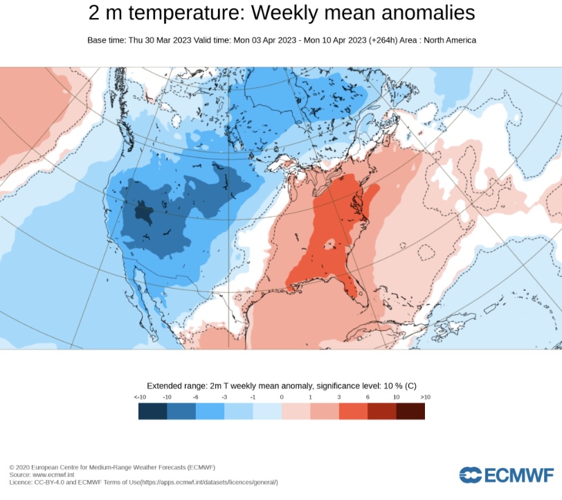
ECMWF weeklies for April 3-10: April gets off to a warm start.
-
This morning, the temperature fell to 31° in Central Park. That will very likely be New York city's last freeze of 2022-2023. The last freeze of 2021-2022 also occurred on March 30th. There are two cases where the last freeze occurred on the same date in two consecutive years: April 3rd in 1906 and 1907 and April 10th in 1974 and 1975. The normal last freeze is March 29th (1991-2020 baseline). The cold will be short-lived. The weather will rapidly turn milder starting tomorrow. Temperatures will likely surge well into the 50s in New York City and into the lower 60s in parts of New Jersey and southeastern Pennsylvania. Saturday will likely start April off on a much warmer than normal note as showers give way to some sunshine. Another cold front could bring showers and thundershowers to the region late in the day. There is some chance that there could be a squall line with strong to perhaps severe thunderstorms. Highs will top out in the upper 60s and lower 70s in the northern Mid-Atlantic region. Overall, the first week of April will likely turn out warmer than normal. As has been the case throughout the winter and early part of spring, the coldest air will remain confined largely to western and central North America. Some of the guidance now brings the cooler air into the East for the second week of April, but considerable uncertainty exists. In terms of the month as a whole, it is somewhat more likely than not that April will wind up on the warm side of normal. Historic experience with very low snowfall totals through February argues that a very snowy March or big snowstorm during March or April are unlikely. There were 16 winters that had less than 8" of snowfall through February in New York City. Just two (13%) had a 6" or greater snowstorm during March or April: 1889-1890: 6.0" on March 19th and 1991-1992: 6.2" on March 19th. With just 2.3" snowfall through March 19, New York City is now extremely likely to finish the season with less than 10" of snow. Since 1869-70, all 10 winters with less than 8.5" of snow through March 19th wound up with less than 10" of seasonal snowfall. New York City is currently on a path that could culminate in its setting a new record for lowest seasonal snowfall. The ENSO Region 1+2 anomaly was +2.0°C and the Region 3.4 anomaly was 0.0°C for the week centered around March 22. For the past six weeks, the ENSO Region 1+2 anomaly has averaged +1.20°C and the ENSO Region 3.4 anomaly has averaged -0.17°C. Neutral ENSO conditions will likely prevail through at least mid-spring. The SOI was -0.72 today. The preliminary Arctic Oscillation (AO) was +1.152 today. On March 28 the MJO was in Phase 3 at an amplitude of 1.033 (RMM). The March 27-adjusted amplitude was 1.039 (RMM). Based on sensitivity analysis applied to the latest guidance, there is an implied near 100% probability that New York City will have a warmer than normal March (1991-2020 normal). March will likely finish with a mean temperature near 44.6° (1.8° above normal normal).
-
It should be 46. I thought I had typed in the correct value.
-
The guidance remains locked on the warm start to April. Even greater warmth is likely later in the first week of April.
-
Morning thoughts… Today will be partly sunny, blustery and unseasonably cold. High temperatures will reach the middle and upper 40s in most of the region. Likely high temperatures around the region include: New York City (Central Park): 46° Newark: 49° Philadelphia: 48° Tomorrow will turn milder but showers will likely arrive. Normals: New York City: 30-Year: 54.9°; 15-Year: 55.1° Newark: 30-Year: 55.8°; 15-Year: 56.6° Philadelphia: 30-Year: 58.0°; 15-Year: 58.7°
-
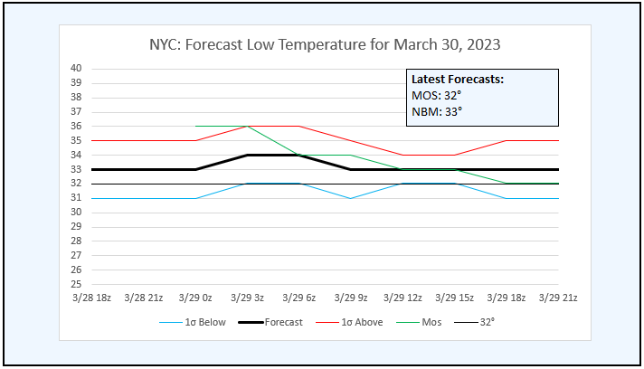
Latest NBM and MOS forecasts for NYC's low temperature tomorrow morning: Often following the passage of strong cold fronts, the MOS does somewhat better than the NBM.
-
Earlier today, the temperature fell to -13° in Bismarck. That surpassed the daily record of -7° from 1964 and was also Bismarck's coldest temperature so late in the season. The previous latest -13° temperature occurred on March 26, 1964 and 1996. Records go back to 1875. Record cold covered the Northern Plains. While most of that air will never reach the northeastern U.S., a small piece of the air mass will race eastward and graze the region. Overnight, some showers of rain and possibly wet snow will affect the area as a strong cold front roars through the region. The frontal passage could bring some briefly heavy snow squalls across central and Upstate New York and central and northern New England. In its wake, tomorrow will be blustery and unseasonably cool despite a return to abundant sunshine. The cold will be short-lived. It will rapidly turn milder as the week comes to a close. Saturday will likely start the month off on a much warmer than normal note as showers give way to some sunshine. Another cold front could bring showers and thundershowers to the region late in the day. There is some chance that there could be a squall line with strong to perhaps severe thunderstorms. Highs will top out in the upper 60s and lower 70s in the northern Mid-Atlantic region. Overall, the first week of April now appears to be in line to average warmer than normal. As has been the case throughout the winter and early part of spring, the coldest air will likely remain in western and central North America. Some of the guidance now brings the cooler air into the East for the second week of April, but considerable uncertainty exists. Historic experience with very low snowfall totals through February argues that a very snowy March or big snowstorm during March or April are unlikely. There were 16 winters that had less than 8" of snowfall through February in New York City. Just two (13%) had a 6" or greater snowstorm during March or April: 1889-1890: 6.0" on March 19th and 1991-1992: 6.2" on March 19th. With just 2.3" snowfall through March 19, New York City is now extremely likely to finish the season with less than 10" of snow. Since 1869-70, all 10 winters with less than 8.5" of snow through March 19th wound up with less than 10" of seasonal snowfall. New York City is currently on a path that could culminate in its setting a new record for lowest seasonal snowfall. The ENSO Region 1+2 anomaly was +2.0°C and the Region 3.4 anomaly was 0.0°C for the week centered around March 22. For the past six weeks, the ENSO Region 1+2 anomaly has averaged +1.20°C and the ENSO Region 3.4 anomaly has averaged -0.17°C. Neutral ENSO conditions will likely prevail through at least mid-spring. The SOI was -10.77 today. The preliminary Arctic Oscillation (AO) was +1.029 today. On March 27 the MJO was in Phase 3 at an amplitude of 1.041 (RMM). The March 26-adjusted amplitude was 1.333 (RMM). Based on sensitivity analysis applied to the latest guidance, there is an implied near 100% probability that New York City will have a warmer than normal March (1991-2020 normal). March will likely finish with a mean temperature near 44.6° (1.8° above normal normal).


