

donsutherland1
-
Posts
24,194 -
Joined
Content Type
Profiles
Blogs
Forums
American Weather
Media Demo
Store
Gallery
Everything posted by donsutherland1
-
Average last date: March 14th. 59% of the time it is on or before March 24th.
-
5.0” on the 22nd and 5.5” for the season.
-
The last hurrah? Putting all the eggs in the Tuesday 3/14 basket
donsutherland1 replied to Ginx snewx's topic in New England
Sorry, I thought you were thinking of the whole storm. My apologies. -
The last hurrah? Putting all the eggs in the Tuesday 3/14 basket
donsutherland1 replied to Ginx snewx's topic in New England
You wrote, “So they must be ignoring the GFS scenario.” A lot of the snow for ORH, not to mention Boston, falls Tuesday night into Wednesday. The map doesn’t reflect storm totals for the whole region. -
The last hurrah? Putting all the eggs in the Tuesday 3/14 basket
donsutherland1 replied to Ginx snewx's topic in New England
The map only goes through 8 pm Tuesday. -
In the wake of the most recent storm, a generally cooler regime is now developing. The colder regime no longer appears as cold relative to normal as it had previously on the guidance. Moreover, there could be some interruptions with periods of milder weather. The colder regime will gradually fade afterward, but will likely persist through the closing week of March. A large storm could affect the region during the March 13-15 timeframe. The coastal plain again risks seeing more rain than snow. Light snowfall amounts remain possible. Cities including Albany, Binghamton, and Concord, along with higher elevations could be in line for a substantial snowfall. Prospects for a significant snowfall have increased for Boston. Parts of central New York State, upstate New York, and central New England have a chance to see 1-2 foot amounts. Historic experience with very low snowfall totals through February argues that a very snowy March or big snowstorm during March or April are unlikely. There were 16 winters that had less than 8" of snowfall through February in New York City. Just two (13%) had a 6" or greater snowstorm during March or April: 1889-1890: 6.0" on March 19th and 1991-1992: 6.2" on March 19th. With just 2.3" snowfall through March 10, New York City is at growing risk of seeing winter 2022-2023 finish with less than 10" of snow. Since 1869-70, 82% of winters with less than 8" of snow through March 10 wound up with less than 10" seasonal snowfall. All such winters wound up with less than 20" of seasonal snowfall. The ENSO Region 1+2 anomaly was +1.1°C and the Region 3.4 anomaly was -0.2°C for the week centered around March 1. For the past six weeks, the ENSO Region 1+2 anomaly has averaged +0.48°C and the ENSO Region 3.4 anomaly has averaged -0.43°C. La Niña conditions have now given way to neutral ENSO conditions. Neutral ENSO conditions will likely prevail through at least mid-spring. The SOI was -4.74 today. The preliminary Arctic Oscillation (AO) was -0.594 today. On March 9 the MJO was in Phase 8 at an amplitude of 4.429 (RMM). The March 8-adjusted amplitude was 4.306 (RMM). Based on sensitivity analysis applied to the latest guidance, there is an implied 52% probability that New York City will have a colder than normal March (1991-2020 normal). March will likely finish with a mean temperature near 42.3° (0.5° below normal).
-
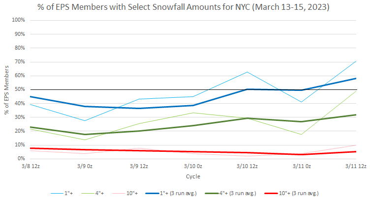
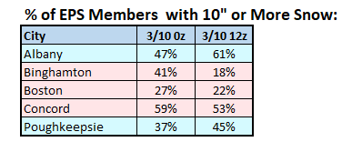
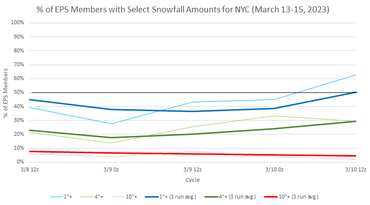
EPS members for NYC: The number of members with large snowfalls of 10" or more has increased in such areas as Boston, Poughkeepsie and White Plains.
-
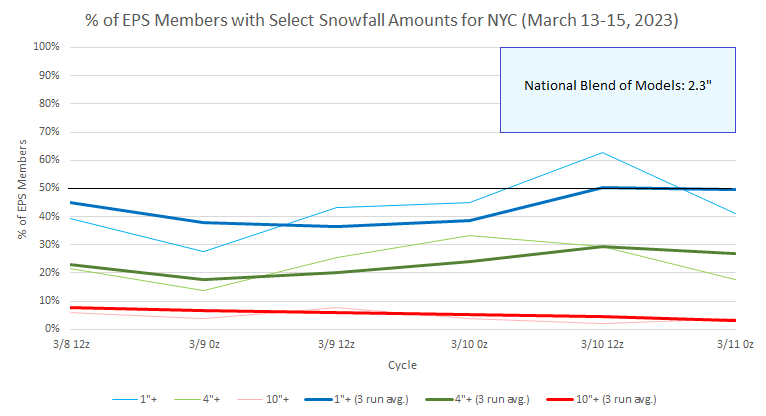
The anomaly maps produced by the vendors don’t show ensemble spread. That’s why it’s useful to look at the percentage of members showing given outcomes. Then, one can gain a sense of the likelihood of a number of scenarios and also how things are evolving over time. That also provides useful context for operational runs. For example, the 12z GFS is much improved for NYC even adjusting 10:1 ratios to more likely 5-7:1 ones. There are a modest number of ensemble members that support that outcome. But it won’t mean much if support on the ensembles doesn’t increase, other models don’t move toward that outcome, etc.
-
The ensembles were never very attractive for this event (500 mb maps were skewed by a small number of high impact scenarios) and the National Blend of Models never went much above an inch (showing a few tenths of an inch most of the time). We'll see what happens with the next event. The NBM was at 2.3" but is falling. The ensembles have some support for a light event, but very little support for a big event. There's still some time for change, but if the ensembles remain essentially where they are today through Sunday's 12z runs, that will be a strong signal for what would largely be a non-event in and around the City. Interior sections are continuing to look good. Boston has even seen ensemble support for 10" or above rise from about one-quarter of members to just over one-third of members. And, in terms of history, if historic experience is representative, NYC is on a trajectory toward a less than 10" season. That's not a guarantee, but that is now a likely outcome.
-
Sadly, this storm provides a fresh reminder that one should never doubt the tenacious persistence of a ratter winter.
-
There’s still considerable uncertainty now that Tuesday-Wednesday is the period in question. By sometime tomorrow there should be a better idea.
-
True. I would accept any snowfall in this miserable winter.
-
Morning thoughts… Rain and snow will end across the region. High temperatures will reach the lower and middle 40s in most of the region. Likely high temperatures around the region include: New York City (Central Park): 45° Newark: 47° Philadelphia: 46° Somewhat cooler than normal to near seasonable readings will likely prevail into the middle of next week. Normals: New York City: 30-Year: 48.1°; 15-Year: 48.4° Newark: 30-Year: 49.1°; 15-Year: 49.9 Philadelphia: 30-Year: 50.9°; 15-Year: 51.3°
-
EPS ensembles:
-
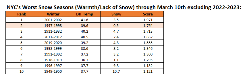
When 2022-23 is added, its numbers impact the means and standard deviations.
-
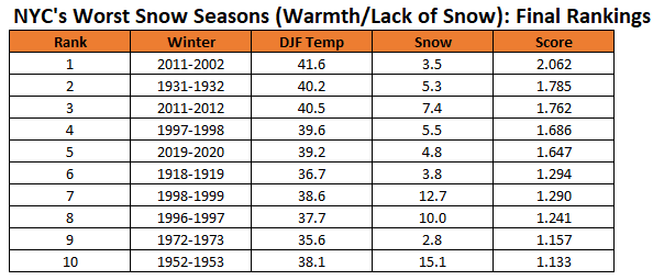
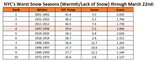
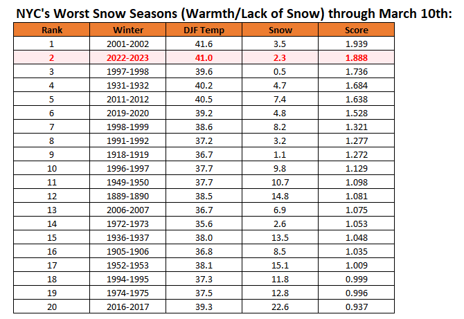
Roger, Please find below: 1. The final rankings 2. Rankings through March 10th, excluding 2022-2023 3. Rankings through March 22nd (to reflect the impact of 1997-1998's 5.0" snowfall) 4. Rankings through March 10th, including 2022-2023
-
A cooler regime is now developing. The March 13-20 timeframe could be the month's coldest week with temperatures averaging 4°- 7° below normal for the week. Nevertheless, severe late-season cold is unlikely. The colder regime will gradually fade afterward, but will likely persist through the closing week of March. A storm will likely bring rain to the coastal plain on this evening into tomorrow. As the storm moves away tomorrow, the rain could end as a period of snow from Philadelphia to New York City. Well north and west of New York City and Newark, 1"-3" of snow could fall. Generally 0.5" or less appears likely in Philadelphia, Newark, and New York City. Another larger storm could affect the region during the March 13-15 timeframe. The coastal plain again risks seeing more rain than snow. Cities including Albany, Binghamton, and Concord, along with higher elevations could be in line for a substantial snowfall. Parts of central New York State, upstate New York, and central New England have a chance to see 1-2 foot amounts. Historic experience with very low snowfall totals through February argues that a very snowy March or big snowstorm during March or April are unlikely. There were 16 winters that had less than 8" of snowfall through February in New York City. Just two (13%) had a 6" or greater snowstorm during March or April: 1889-1890: 6.0" on March 19th and 1991-1992: 6.2" on March 19th. With just 2.3" snowfall through March 10, New York City is at growing risk of seeing winter 2022-2023 finish with less than 10" of snow. Since 1869-70, 82% of winters with less than 8" of snow through March 10 wound up with less than 10" seasonal snowfall. All such winters wound up with less than 20" of seasonal snowfall. The ENSO Region 1+2 anomaly was +1.1°C and the Region 3.4 anomaly was -0.2°C for the week centered around March 1. For the past six weeks, the ENSO Region 1+2 anomaly has averaged +0.48°C and the ENSO Region 3.4 anomaly has averaged -0.43°C. La Niña conditions have now given way to neutral ENSO conditions. Neutral ENSO conditions will likely prevail through at least mid-spring. The SOI was +5.17 today. The preliminary Arctic Oscillation (AO) was -1.297 today. On March 8 the MJO was in Phase 8 at an amplitude of 4.281 (RMM). The March 7-adjusted amplitude was 3.913 (RMM). Based on sensitivity analysis applied to the latest guidance, there is an implied 55% probability that New York City will have a colder than normal March (1991-2020 normal). March will likely finish with a mean temperature near 42.0° (0.8° below normal).
-
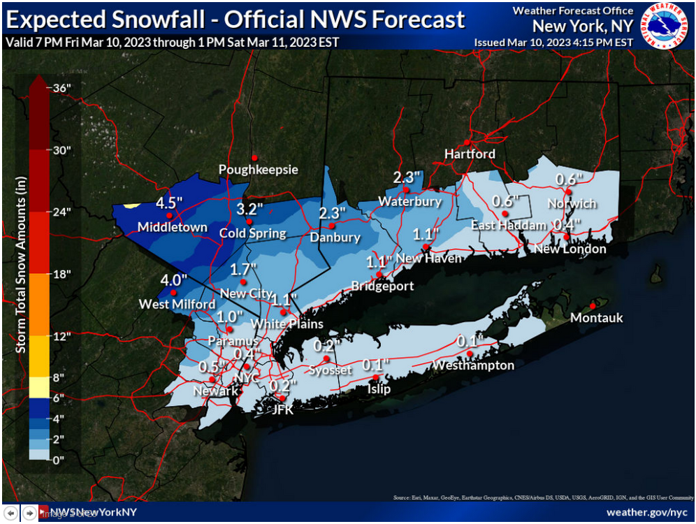
Latest NWS forecast:
-
I’m just referring to the timeframe of the storm. For NYC and nearby areas, Tuesday could be the better bet. We should get a lot of precipitation and strong winds, even if the snow disappoints.
-
For now, it seems reasonable for Monday-Tuesday.
-
Select EPS Data:
-
Latest EPS ensemble members for NYC:
-
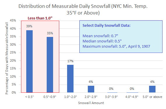
With the temperature likely to remain at or above 35° throughout the precipitation event tonight and tomorrow in New York City, historical odds support growing model support for less than 1" of snow in Central Park. Almost three-quarters of events with a minimum temperature of 35° or above (n=23 from 1869-present), saw less than 1" of snow. My thinking remains 0.5" or less for New York City and Newark with a risk that either or both cities could see no measurable snowfall whatsoever.
-
The NBM comes out hourly.
-
The UKMET has, unfortunately, backed off from big snows around the NYC area.


