donsutherland1
-
Posts
24,194 -
Joined
Content Type
Profiles
Blogs
Forums
American Weather
Media Demo
Store
Gallery
Everything posted by donsutherland1
-
Yes, that’s correct. In included it, because I started from the beginning of NYC’s record.
-
Morning thoughts… Today will be sunny but cool. High temperatures will reach the middle 40s in most of the region. Likely high temperatures around the region include: New York City (Central Park): 45° Newark: 47° Philadelphia: 48° It will turn milder tomorrow. Normals: New York City: 30-Year: 49.3°; 15-Year: 50.0° Newark: 30-Year: 50.4°; 15-Year: 51.3 Philadelphia: 30-Year: 52.3°; 15-Year: 52.8°
-
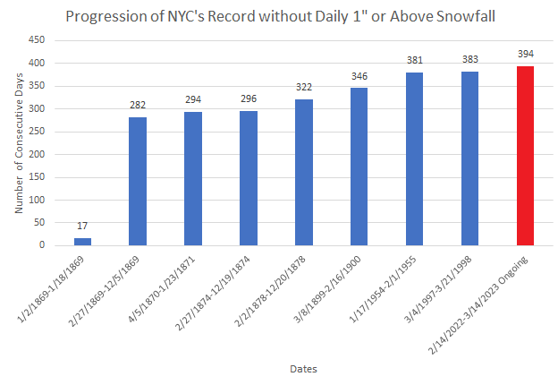
The progression of New York City's record streaks without daily snowfall of 1" or above:
-
Here's where 2022-2023 stands following today's lack of measurable snowfall in New York City:
-
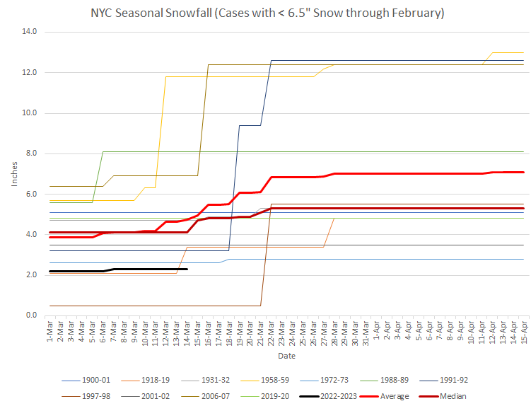
As had been a possibility prior to the big nor'easter, New York City picked up no measurable snowfall from the storm. Places less than 30 miles outside of the City such as Rye Brook saw the ground whitened. As a result, New York City remains on a path that could culminate in its lowest seasonal snowfall on record. After a blustery day tomorrow, milder air will return to the region. Thursday through Saturday could see readings reach the 50s in much of the region. Cooler air will likely return to close the weekend. Historic experience with very low snowfall totals through February argues that a very snowy March or big snowstorm during March or April are unlikely. There were 16 winters that had less than 8" of snowfall through February in New York City. Just two (13%) had a 6" or greater snowstorm during March or April: 1889-1890: 6.0" on March 19th and 1991-1992: 6.2" on March 19th. With just 2.3" snowfall through March 10, New York City is at growing risk of seeing winter 2022-2023 finish with less than 10" of snow. Since 1869-70, 82% of winters with less than 8" of snow through March 10 wound up with less than 10" seasonal snowfall. All such winters wound up with less than 20" of seasonal snowfall. The ENSO Region 1+2 anomaly was +1.5°C and the Region 3.4 anomaly was -0.1°C for the week centered around March 8. For the past six weeks, the ENSO Region 1+2 anomaly has averaged +0.76°C and the ENSO Region 3.4 anomaly has averaged -0.35°C. Neutral ENSO conditions will likely prevail through at least mid-spring. The SOI was -6.89 today. The preliminary Arctic Oscillation (AO) was +0.616 today. On March 12 the MJO was in Phase 8 at an amplitude of 4.161 (RMM). The March 11-adjusted amplitude was 4.197 (RMM). Based on sensitivity analysis applied to the latest guidance, there is an implied 51% probability that New York City will have a colder than normal March (1991-2020 normal). March will likely finish with a mean temperature near 42.5° (0.3° below normal).
-
New York Botanical Garden (Bronx, NY):
-
With New York City likely to see less than 1" of snow today, the ongoing record without a 1" or greater daily snowfall will reach 394 days. The old record was 383 days (March 4, 1997 through March 21, 1998).
-
Borderline moderate snow in the Bronx. Strong winds are whipping the large flakes about. The day has the "look" of winter, but there is no accumulation.
-
That's certainly possible. It's not assured, yet. But the long-range guidance is generally in the 40s and 50s.
-
Some wet snowflakes are mixing with the rain in Larchmont, NY.
-
Right now, there’s only a low probability. The cooler weather will still be too mild for snow, as seasonal norms are now nearing 50 and will be above 50 in coming days.
-
Morning thoughts… Rain and snow will give way to snow. New York City will see 1” or less. Nearby suburbs could pick up 1”-3”. Distant northern and western suburbs remain in line for 4”-8”. High temperatures will reach the upper 30s and perhaps lower 40s in most of the region. Likely high temperatures around the region include: New York City (Central Park): 39° Newark: 40° Philadelphia: 41° Milder weather will return Thursday. Normals: New York City: 30-Year: 49.0°; 15-Year: 49.7° Newark: 30-Year: 50.0°; 15-Year: 50.9 Philadelphia: 30-Year: 51.9°; 15-Year: 52.4°
-
A large storm will continue to impact the region through tomorrow. However, on account of a shortage of cold air and the storm's track and development, snowfall amounts in Philadelphia, New York City, and Newark will be less than an inch. There remains some possibility that New York City might pick up little or no measurable snowfall. The far northern and western suburbs will likely see 4"-8" of snow. Parts of central New York State, upstate New York, and central New England have a chance to see 1-2 foot amounts. Milder air will return to the region for several days following midweek. Afterward, it will again turn late during the weekend. Historic experience with very low snowfall totals through February argues that a very snowy March or big snowstorm during March or April are unlikely. There were 16 winters that had less than 8" of snowfall through February in New York City. Just two (13%) had a 6" or greater snowstorm during March or April: 1889-1890: 6.0" on March 19th and 1991-1992: 6.2" on March 19th. With just 2.3" snowfall through March 10, New York City is at growing risk of seeing winter 2022-2023 finish with less than 10" of snow. Since 1869-70, 82% of winters with less than 8" of snow through March 10 wound up with less than 10" seasonal snowfall. All such winters wound up with less than 20" of seasonal snowfall. The ENSO Region 1+2 anomaly was +1.1°C and the Region 3.4 anomaly was -0.2°C for the week centered around March 1. For the past six weeks, the ENSO Region 1+2 anomaly has averaged +0.48°C and the ENSO Region 3.4 anomaly has averaged -0.43°C. La Niña conditions have now given way to neutral ENSO conditions. Neutral ENSO conditions will likely prevail through at least mid-spring. The SOI was -14.36 today. The preliminary Arctic Oscillation (AO) was +0.438 today. On March 11 the MJO was in Phase 8 at an amplitude of 4.200 (RMM). The March 10-adjusted amplitude was 4.310 (RMM). Based on sensitivity analysis applied to the latest guidance, there is an implied 51% probability that New York City will have a colder than normal March (1991-2020 normal). March will likely finish with a mean temperature near 42.3° (0.5° below normal).
-
March-April 1996 had 2 4" or above snowstorms at JFK Airport. There was an additional 3" storm.
-
March-April Measurable Snowfalls for NYC in 1956: March 12-13: 1.6" March 16-17: 6.7" March 18-19: 11.6" March 24: 1.2 April 8: 4.2"
-
I'm truly sorry to learn of your loss, Chris. I regret that my family and I don't have a spare room. I very much hope that your search will be successful soon.
-
Periodic extreme forecast update... The extreme forecast in question called for March 1-April 15 to have an average temperature of 5° below normal with 20" or more snow in New York City. The forecast always had very little chance of ever verifying. At present, the temperature would need to average 7.5° below normal from March 14-April 15 (40.0° against the 1991-2020 normals). The last time a year had an average temperature of 40.0° or below from March 14-April 15 was in 1956. 13/16 cases with such temperatures occurred prior to 1900. Through today, it is likely that NYC's snowfall since March 1st will remain stuck at 0.1". That means an additional 19.9" would be needed through April 15th to verify the forecast. Only a single year in NYC's climate record, which extends back to 1869, had 19.9" or more snow from March 14-April 15: 1956 with 23.7". In sum, the initially steep hill required for the extreme forecast to verify is growing each day into an ever higher mountain.
-
Morning thoughts… Rain will fall along the coastal plain. In the far northern and western suburbs, rain changing to wet snow will fall. High temperatures will reach the lower and middle 40s in most of the region. Likely high temperatures around the region include: New York City (Central Park): 44° Newark: 46° Philadelphia: 46° Tomorrow will be stormy with windswept heavy rain on the coast possibly mixing with and ending as some snow with only minor accumulations at best. The far northern and western suburbs could see 4”-8” of snow. Normals: New York City: 30-Year: 48.7°; 15-Year: 49.3° Newark: 30-Year: 49.7°; 15-Year: 50.6 Philadelphia: 30-Year: 51.6°; 15-Year: 52.1°
-
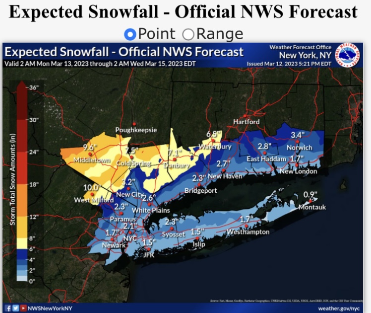
The latest NWS forecast for reference:
-
A generally cooler regime is now in place. The colder regime no longer appears as cold relative to normal as it had previously on the guidance. Moreover, there could be some interruptions with periods of milder weather. The colder regime will likely persist through the closing week of March. A large storm will impact the region during the March 13-15 timeframe. Philadelphia will likely see 0.5" or less. New York City and Newark will likely pick up 1"-2". There remains some possibility that New York City might pick up little or no measurable snowfall. The far northern and western suburbs will likely see 4"-8" of snow. Parts of central New York State, upstate New York, and central New England have a chance to see 1-2 foot amounts. Historic experience with very low snowfall totals through February argues that a very snowy March or big snowstorm during March or April are unlikely. There were 16 winters that had less than 8" of snowfall through February in New York City. Just two (13%) had a 6" or greater snowstorm during March or April: 1889-1890: 6.0" on March 19th and 1991-1992: 6.2" on March 19th. With just 2.3" snowfall through March 10, New York City is at growing risk of seeing winter 2022-2023 finish with less than 10" of snow. Since 1869-70, 82% of winters with less than 8" of snow through March 10 wound up with less than 10" seasonal snowfall. All such winters wound up with less than 20" of seasonal snowfall. The ENSO Region 1+2 anomaly was +1.1°C and the Region 3.4 anomaly was -0.2°C for the week centered around March 1. For the past six weeks, the ENSO Region 1+2 anomaly has averaged +0.48°C and the ENSO Region 3.4 anomaly has averaged -0.43°C. La Niña conditions have now given way to neutral ENSO conditions. Neutral ENSO conditions will likely prevail through at least mid-spring. The SOI was -11.92 today. The preliminary Arctic Oscillation (AO) was -0.042 today. On March 10 the MJO was in Phase 8 at an amplitude of 4.327 (RMM). The March 9-adjusted amplitude was 4.427 (RMM). Based on sensitivity analysis applied to the latest guidance, there is an implied 52% probability that New York City will have a colder than normal March (1991-2020 normal). March will likely finish with a mean temperature near 42.3° (0.5° below normal).
-
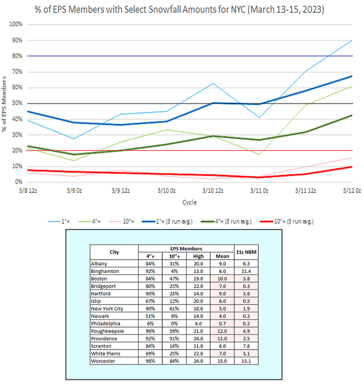
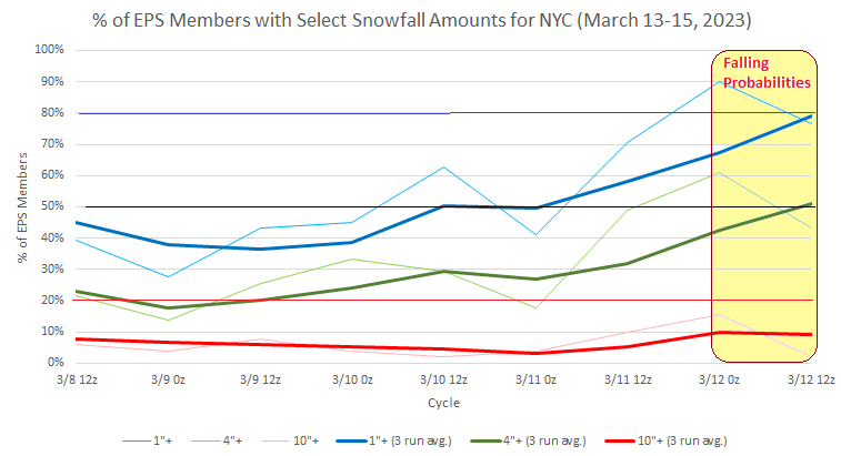
Latest EPS members for NYC:
-
That’s why I mentioned advisories. There’s still uncertainty where the 6” line will be.
-
There will very likely be advisories or watches in the afternoon package.
-
The NBM has edged up to 2.3" as of 12z.
-
EPS members and NBM data. Note: the NBM takes into consideration ratios. The EPS members are based on 10:1 ratios. Most areas will see ratios of 5:1 to 7:1.