donsutherland1
-
Posts
24,193 -
Joined
Content Type
Profiles
Blogs
Forums
American Weather
Media Demo
Store
Gallery
Everything posted by donsutherland1
-
That would be great if the needed 0.7" falls.
-
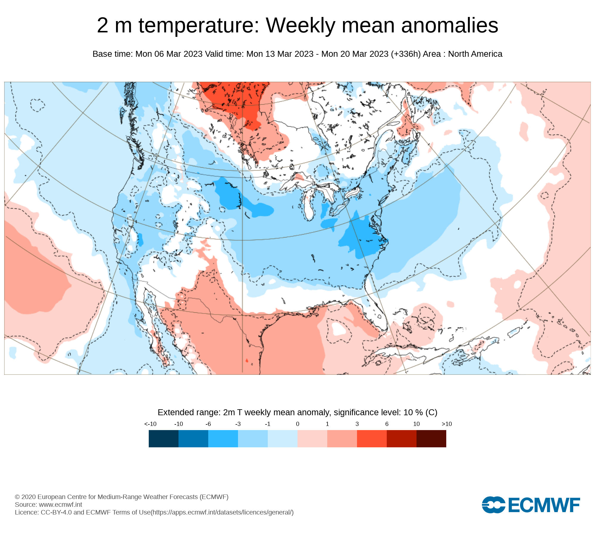
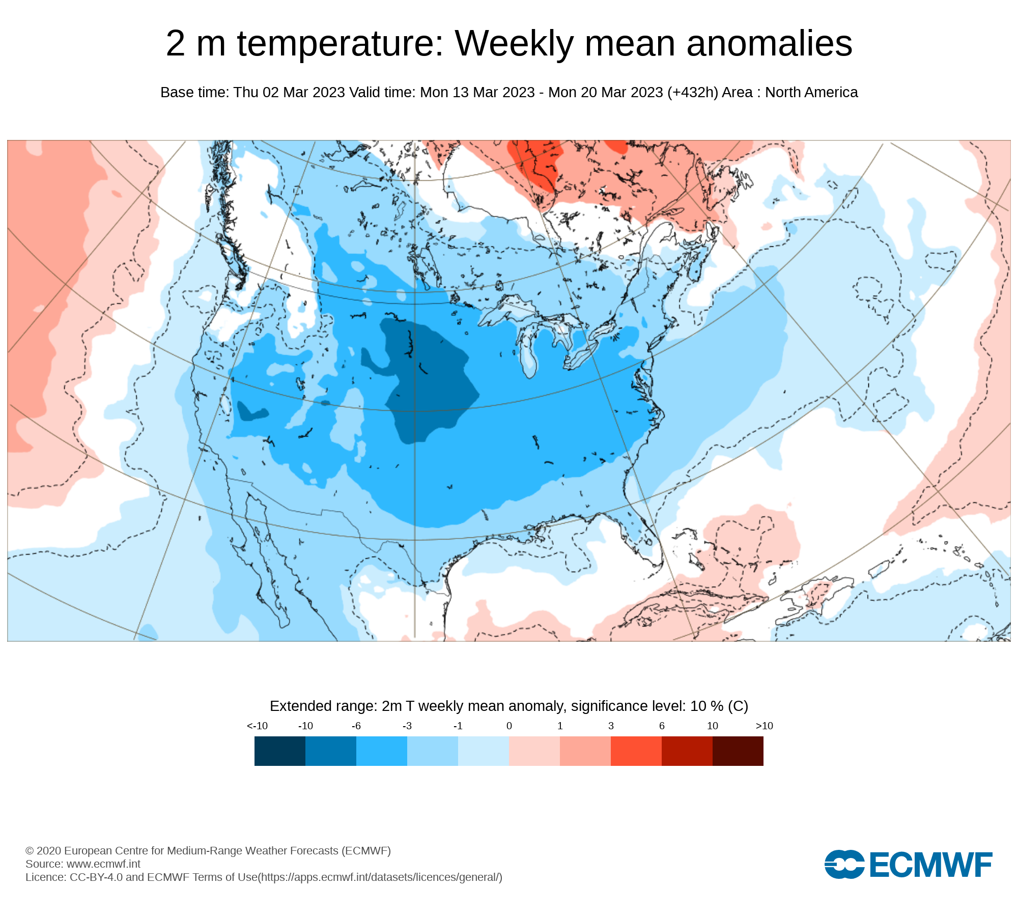
The latest ECMWF weeklies are not as cold for March 13-20 as they were last week. 3/2: 3/6:


-
The 3/5 0z ECMWF had it. Hopefully, the more wrapped up ensemble members will prove to be correct. There's still plenty of time left.
-
The last time it occurred at Central Park was way back in 1967.
-
No. NYC has never gone below zero in March since regular recordkeeping began in 1869. The March record of 3° was set on March 5, 1872.
-
Yes. It should be over before sunrise. JFK: 3/18-19: 3.2”; 3/22: 3.7” LGA: 3/18-19: 6.6”; 3/22: 3.6” NYC: 3/18-19: 6.2”; 3/22: 3.2”
-
It's going to be a close call for the City. I think the high-resolution models will tell the story, especially the 18z and 0z runs. My initial thoughts are that that accumulating snow would grave the City. Measurable amounts in Central Park will be a close call, as it is plausible that JFK, Brooklyn, Queens, and Staten Island see some accumulations while the Park falls just short.
-
Morning thoughts… Today will be partly sunny and mild. High temperatures will reach the lower and middle 50s in most of the region. Likely high temperatures around the region include: New York City (Central Park): 52° Newark: 54° Philadelphia: 55° It will become somewhat cooler tomorrow. Normals: New York City: 30-Year: 46.6°; 15-Year: 47.1° Newark: 30-Year: 47.7°; 15-Year: 48.3° Philadelphia: 30-Year: 49.3°; 15-Year: 49.6°
-
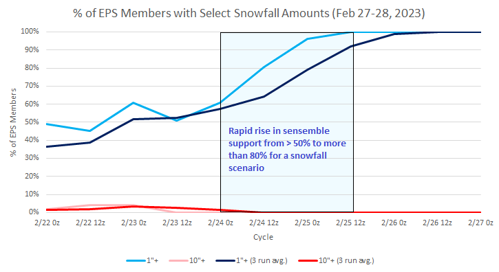
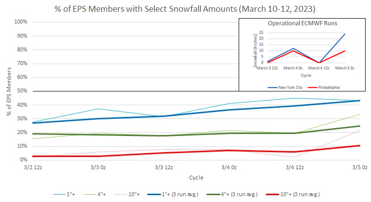
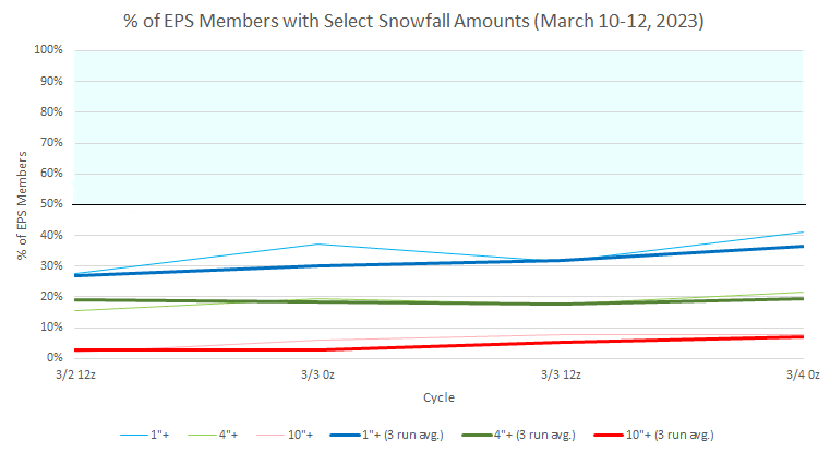
3/6 0z EPS Members: Notes: 1. The operational ECMWF did not go wild at 0z for the first time in 3 0z runs 2. A focus on ensembles over the operational guidance is useful as uncertainty remains considerable 3. In the next 24-72 hours, the picture should be much clearer Below is an illustration of what things should look like when the ensembles lock in on a potential event. This chart is from the late February event that saw 1.8" fall at Central Park.
-
Milder weather returned today. Temperatures surged into the 50s across the region and approached 60° in southeastern Pennsylvania. Tomorrow will be another mild day A colder regime will develop starting later this week. At present, no severe March cold appears likely. However, the March 13-20 timeframe could be the month's coldest week with temperatures averaging 5°- 8° below normal for the week. The colder regime will gradually fade afterward, but could last into or even through the closing week of March. The operational ECMWF has been oscillating wildly on a run-to-run basis in terms of snowfall for the northern Mid-Atlantic region for the March 10-12 period: March 3 12z: New York City: 1"; Philadelphia: 0" March 4 0z: New York City: 12"; Philadelphia: 10" March 4 12z: New York City: 0"; Philadelphia: 0" March 5 0z: New York City: 24"; Philadelphia: 10" March 5 12z: New York City: 4"; Philadelphia: 1" These heart-stopping swings signal a volatile period with high potential that could either bring great joy to the snow-starved region or massive heartbreak. Extreme solutions should be discounted without strong and sustained support. Instead, until run-to-run continuity improves, one should focus on developments on the ensembles, especially as historic experience has not been kind. Historic experience with very low snowfall totals through February argues that a very snowy March or big snowstorm during March or April are unlikely. Despite attractive 500 mb patterns, the base case is that at least through March 10th, snowfall will likely be below normal from Philadelphia to New York City. For further historical perspective, there were 16 winters that had less than 8" of snowfall through February in New York City. Just two (13%) had a 6" or greater snowstorm during March or April: 1889-1890: 6.0" on March 19th and 1991-1992: 6.2" on March 19th. Historical perspective argues for caution when the operational models are popping big snowstorms into and out of existence like quantum particles in the extended range. The ENSO Region 1+2 anomaly was +0.4°C and the Region 3.4 anomaly was -0.3°C for the week centered around February 22. For the past six weeks, the ENSO Region 1+2 anomaly has averaged +0.25°C and the ENSO Region 3.4 anomaly has averaged -0.50°C. La Niña conditions fading and they should evolve to neutral conditions during late winter or early spring. The SOI was -4.55 today. The preliminary Arctic Oscillation (AO) was -1.640 today. On March 3 the MJO was in Phase 7 at an amplitude of 2.208 (RMM). The March 2-adjusted amplitude was 1.841 (RMM).
-
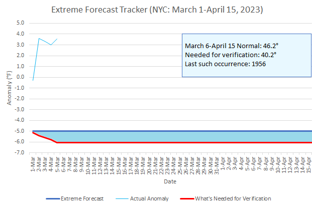
In terms of the extreme forecast made for NYC to average 5° below normal for March 1-April 15, the needed anomaly for the remainder of the period has increased to 6.0° below normal.
-
Morning thoughts… Today will be partly sunny and noticeably milder. High temperatures will reach the lower and middle 50s in most of the region. Likely high temperatures around the region include: New York City (Central Park): 53° Newark: 55° Philadelphia: 59° The mild weather will continue tomorrow. Normals: New York City: 30-Year: 46.4°; 15-Year: 46.8° Newark: 30-Year: 47.4°; 15-Year: 48.0° Philadelphia: 30-Year: 49.0°; 15-Year: 49.2°
-
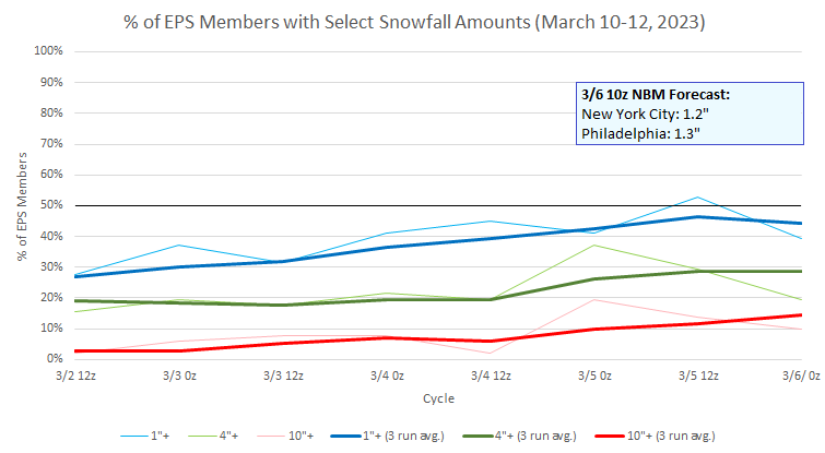
EPS Snowfall amounts for New York City and last four runs of the operational ECMWF for New York City and Philadelphia:
-
In the wake of the storm that brought heavy rain and coastal flooding to the region overnight into today, milder weather will follow tomorrow and continue into early next week. Afterward, it will turn more seasonable for a time. A colder regime will develop during the second week of the March. At present, no severe March cold appears likely. However, the March 13-20 timeframe could be the month's coldest week with temperatures averaging 5°- 8° below normal for the week. The colder regime will gradually fade afterward, but could last into or even through the closing week of March. Historic experience with very low snowfall totals through February argues that a very snowy March or big snowstorm during March or April are unlikely. Despite attractive 500 mb patterns, the base case is that at least through March 10th, snowfall will likely be below normal from Philadelphia to New York City. For further historical perspective, there were 16 winters that had less than 8" of snowfall through February in New York City. Just two (13%) had a 6" or greater snowstorm during March or April: 1889-1890: 6.0" on March 19th and 1991-1992: 6.2" on March 19th. Historical perspective argues for caution when the operational models are popping big snowstorms into and out of existence like quantum particles in the extended range. The ENSO Region 1+2 anomaly was +0.4°C and the Region 3.4 anomaly was -0.3°C for the week centered around February 22. For the past six weeks, the ENSO Region 1+2 anomaly has averaged +0.25°C and the ENSO Region 3.4 anomaly has averaged -0.50°C. La Niña conditions fading and they should evolve to neutral conditions during late winter or early spring. The SOI was +0.19 today. The preliminary Arctic Oscillation (AO) was +0.186 today. On March 2 the MJO was in Phase 7 at an amplitude of 1.836 (RMM). The March 1-adjusted amplitude was 1.389 (RMM).
-
Yes. This year’s figure is 1.7”.
-
No. NYC is now at 2.2”. The record is 2.8” during 1972-73.
-
Morning thoughts… Rain will end and clouds could break late in the day. High temperatures will reach the middle and upper 40s in most of the region. Likely high temperatures around the region include: New York City (Central Park): 47° Newark: 49° Philadelphia: 51° It will turn milder on tomorrow. Normals: New York City: 30-Year: 46.1°; 15-Year: 46.5° Newark: 30-Year: 47.1°; 15-Year: 47.7° Philadelphia: 30-Year: 48.7°; 15-Year: 48.9°
-
EPS ensembles for the March 10-12 period:
-
Some sleet is falling in Larchmont, NY.
-
A storm will bring rain to Philadelphia, Newark, and New York City overnight into Saturday. A general 0.50"-1.50" of rain is likely. Some frozen precipitation is possible well to the north and west of the cities. A moderate to significant snowfall is likely across central New York State and central to northern New England. Albany could see 4"-8" of snow. After what increasingly appears to be a warmer than normal first week to March, a colder regime could develop during the second week of the month. At present, no severe March cold appears likely. However, the March 13-20 timeframe could be the month's coldest week with temperatures averaging 5°- 8° below normal for the week. The colder regime will gradually fade afterward, but could last into or even through the closing week of March. Historic experience with very low snowfall totals through February argues that a very snowy March or big snowstorm during March or April are unlikely. Despite attractive 500 mb patterns, the base case is that at least through March 10th, snowfall will likely be below normal from Philadelphia to New York City. For further historical perspective, there were 16 winters that had less than 8" of snowfall through February in New York City. Just two (13%) had a 6" or greater snowstorm during March or April: 1889-1890: 6.0" on March 19th and 1991-1992: 6.2" on March 19th. Historical perspective argues for caution when the operational models are popping big snowstorms into and out of existence like quantum particles in the extended range. The ENSO Region 1+2 anomaly was +0.4°C and the Region 3.4 anomaly was -0.3°C for the week centered around February 22. For the past six weeks, the ENSO Region 1+2 anomaly has averaged +0.25°C and the ENSO Region 3.4 anomaly has averaged -0.50°C. La Niña conditions fading and they should evolve to neutral conditions during late winter or early spring. The SOI was +6.84 today. The preliminary Arctic Oscillation (AO) was +1.086 today. On March 1 the MJO was in Phase 6 at an amplitude of 1.385 (RMM). The February 28-adjusted amplitude was 1.255 (RMM).
-
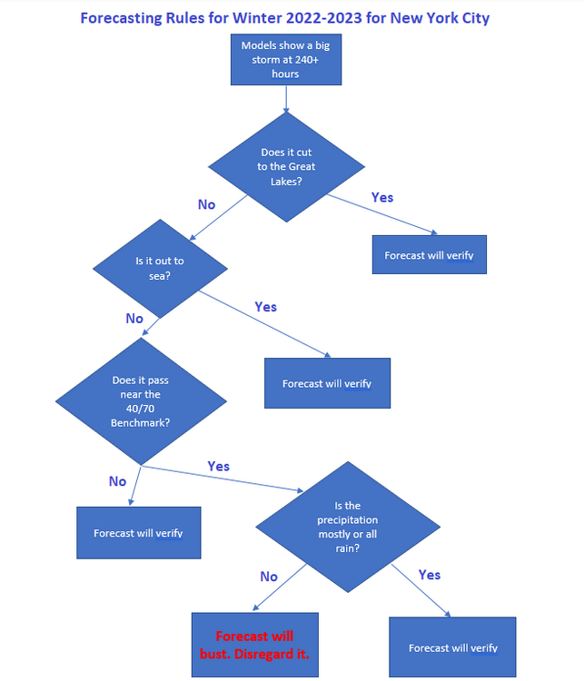
Following today's elimination of the extended range major snowstorm on the models, some rules that seem to apply to Winter 2022-2023 are below:
-
What the prolonged near total absence of snow does to those in the Middle Atlantic forums of AmericanWx (New York City, Philadelphia, Mid-Atlantic). That the map could disappear with the next run is irrelevant:

-
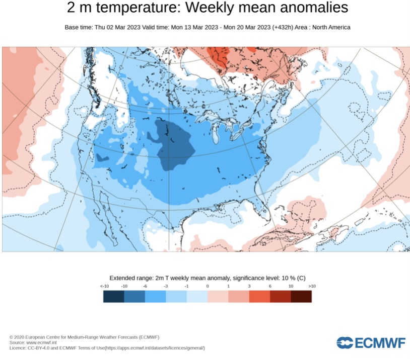
The latest ECMWF weekly forecast for March 13-20 maintained the longstanding cold idea. That might offer the Mid-Atlantic region its best opportunity for at least some snowfall.
-
Probably between 6 pm and 8 pm.