

donsutherland1
-
Posts
24,192 -
Joined
Content Type
Profiles
Blogs
Forums
American Weather
Media Demo
Store
Gallery
Everything posted by donsutherland1
-
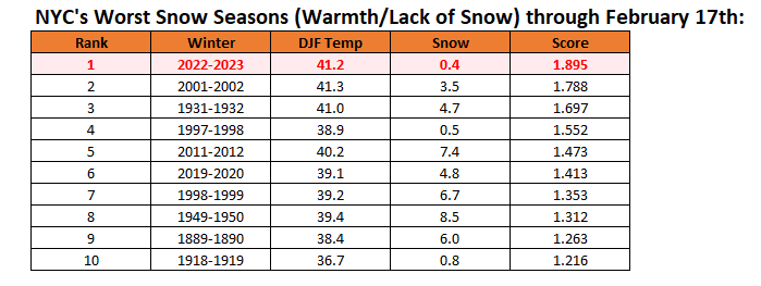
New York City's snow season futility rankings through February 17th:
-
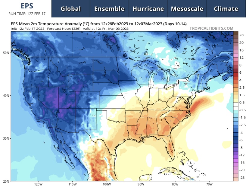
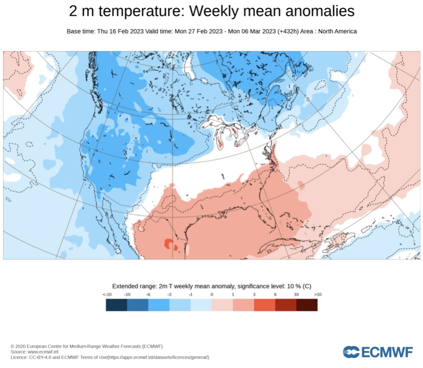
If blocking develops, there would be a colder outcome. Right now, beyond the opening of March, there is a lot of uncertainty even as the CFSv2 remains stubbornly warm.
-
Day 10-14 EPS forecast.
-
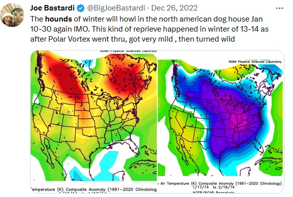
He used to be a good forecaster. Even the best ones can make big errors from time to time. He has changed dramatically since around 2010. I focused on the two big flaws that now appear apparent in his forecasting framework. I personally hope his better days from the past won’t be forgotten.
-
Colder air is now pressing into the region. Tomorrow will be blustery and noticeably colder than today. Readings will generally reach the lower 40s. Temperatures will run generally above to much above normal through the third week of February. Afterward, temperatures could cool during the closing 7 days of the month. That could afford an opportunity for a snowfall in the Mid-Atlantic region during the February 23-25 timeframe. More than likely, any snowfall would be modest. At this timeframe, a snowfall is not a guaranteed outcome. No severe shots of cold appear likely through February. Among the extended range scenarios on the table is a late February-early March 2002-type outcome. Under such a scenario, cold air would flood into the Plains States, but persistent southeast ridging would keep most of the cold away from the northeastern and Mid-Atlantic United States. During February 28-March 5, 2002 high temperatures in the New York City area generally reached the lower to middle 40s with low temperatures in the 20s at night. At the height of the cold, one night saw the temperature fall into the upper teens. By March 7, the cold was gone and readings return to much above normal levels. The ENSO Region 1+2 anomaly was +0.7°C and the Region 3.4 anomaly was -0.5°C for the week centered around February 8. For the past six weeks, the ENSO Region 1+2 anomaly has averaged -0.12°C and the ENSO Region 3.4 anomaly has averaged -0.62°C. La Niña conditions fading and they should evolve to neutral conditions during late winter or early spring. The SOI was +9.27 today. The preliminary Arctic Oscillation (AO) was +1.767 today. On February 15 the MJO was in Phase 6 at an amplitude of 1.934 (RMM). The February 14-adjusted amplitude was 2.337 (RMM). Based on sensitivity analysis applied to the latest guidance, there is an implied near 100% probability that New York City will have a warmer than normal February (1991-2020 normal). February will likely finish with a mean temperature near 40.9° (5.0° above normal).
-
The extreme forecast appears to be a last-ditch swing for the fences in what has been a disastrous winter forecast in among the warmest winters on record. Such tweets undermine the credibility of profession, because of the visibility and attention they garner. With respect to the -5° anomaly/20"+ snowfall idea, I posted previously on that matter for NYC. Overall, the probability of such an outcome remains exceptionally low. There is no support on the most recent ECMWF weeklies or CFSv2 for the kind of sustained cold required. The verification tweet for mid-November through December is not exactly accurate. He referred to "big end-game, cold." Yet, the area of 1° or more below normal anomalies for this period was quite small. Had there not been the short-lived severe Arctic blast in late December, that area would have been even smaller. Nevertheless, the anomalies fall far short of what was described. With regard to his "wishcast" tweet, there is a material omission. He had expected severe cold for the January 10-30 period. The January 10-30, 2023 outcome could not have been more different from his idea: Boston: Mean Temperature: 37.5° (8th warmest); Snowfall: 6.4" New York City: Mean Temperature: 42.0° (3rd warmest); Snowfall: Trace Philadelphia: Mean Temperature: 41.6° (7th warmest); Snowfall: None Washington, DC: Mean Temperature: 43.1° (tied 12th warmest); Snowfall: Trace All four cities wound up with among their warmest Januaries on record. Boston (5th warmest), New York City (1st warmest), Philadelphia (2nd warmest), and Washington, DC (3rd warmest). Why have things gone so badly? Two possible issues may be involved: 1) His "analog" method 2) His approach to using the guidance Analogs can provide useful insight when three conditions exist: they are selected in an objective fashion (different people should be able to reproduce them from a consistent methodology), their limitations (lack of synoptic scale value, sample size, uncertainty) are respected, and reasonable comparability exists (relatively stable climate) across the period of time. Today, the climate is warming and it is notably warmer than it was even a few decades ago. The dynamic warming and extent of warming that has occurred have undermined analog comparability and reduced valid analog pools to very small sample sizes. His approach to using models and ensembles is flawed. He has often suggested that he arrives at conclusions and then chooses the guidance that favors those conclusions. Two or three decades ago when the guidance had much less skill, the hazards of that approach would have been less evident. The noise of model error would have drowned out the error from a flawed approach to using the models. Today, the hazards of that flawed approach are inescapable. In general, one should look at the evidence, including the guidance, and only then reach conclusions. One should not reach preconceived conclusions and then essentially filter evidence simply because it confirms one's ideas. Confirmation bias is lethal to good analyses and decision-making. It also undermines the possibility of utilizing lessons from post-verification assessments. Overall, long-range forecasting remains a low-skill endeavor. However, an inherently flawed approach to forecasting can greatly increase the frequency and magnitude of one's errors. I suspect that's the bigger story here.
-
Some sleet pellets are mixing in with the light rain in Larchmont, NY.
-
Once the PNA gets to -1.000 or below, the percentage of moderate or greater snowstorms (4" or more) falls. No storms after February 16 with a PNA of -1.000 or below saw 8" or more of snow. But there are a number of 4"-7" storms. In this pathetic winter, that would be a great storm.
-
Yes. The last week of the month will be key.
-
The final winter average for 2001-02 was 41.6. We may fall short.
-
IMO, 1997-98 is useful, because it shows that it is possible to have less than 1” seasonal snowfall in NYC during a snow season. Without the March 22nd snowfall, that’s where the winter would have finished. Maybe this winter will be the first with less than an inch, but I hope that won’t be the case. I would much rather have at least one moderate snowfall than a record worst snow season. January-February will easily be the warmest January-February period on record for NYC (likely by more than one-degree).
-
Morning thoughts… Today will be partly to mostly cloudy and unseasonably warm. Showers and thundershowers are possible. High temperatures will reach the upper 50s and lower 60s in most areas. Likely high temperatures around the region include: New York City (Central Park): 62° Newark: 64° Philadelphia: 63° A cooler but not cold weekend will follow. Normals: New York City: 30-Year: 42.6°; 15-Year: 42.6° Newark: 30-Year: 43.4°; 15-Year: 43.5° Philadelphia: 30-Year: 44.7°; 15-Year: 44.5°
-
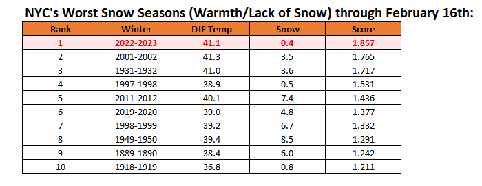
New York City's snow season futility rankings through February 16th:
-
Latest ECMWF weekly forecast for February 27-March 6: a modest improvement from Monday’s run.
-
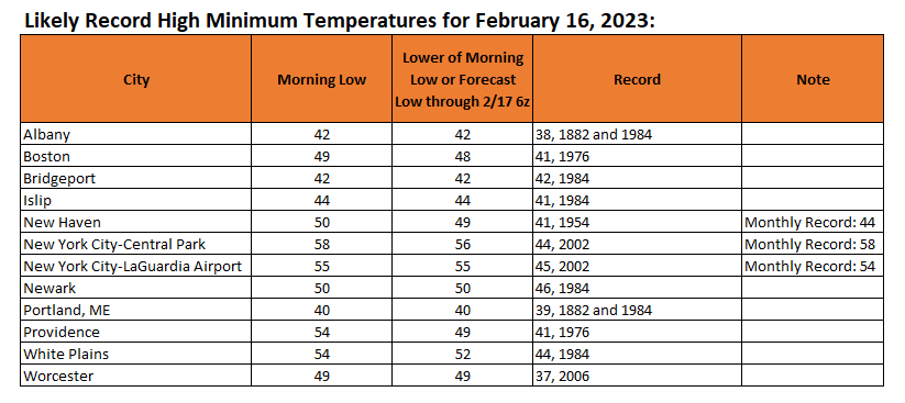
Temperatures peaked today ahead of a cold front that will bring cooler air to the region later tomorrow through the weekend. At Central Park, the temperature topped out at 70°. Many locations saw record warmth. Records included: Bangor: 52° (tied record set in 2006) Binghamton: 61° (old record: 58°, 1954) Boston: 62° (old record: 60°, 1882 and 1910) Bridgeport: 68° (old record: 57°, 1976, 1982, and 2015) ***New February Record*** Islip: 71° (old record: 59°, 1976 and 2018) ***New February Record*** New Haven: 68° (old record: 59°, 1954) ***New February Record*** New York City-JFK: 64° (old record: 61°, 1976) New York City-LGA: 69° (tied record set in 1954) Portland: 57° (old record: 51°, 188, 1891, and 1981) Providence: 71° (old record: 60°, 1910) White Plains: 67° (old record: 66°, 1954) Temperatures will run generally above to much above normal through the third week of February. Afterward, temperatures could cool during the closing 7 days of the month. That could afford an opportunity for a snowfall in the Mid-Atlantic region during the February 22-24 timeframe. More than likely, any snowfall would be modest. At this timeframe, a snowfall is not a guaranteed outcome. No severe shots of cold appear likely through February. Among the extended range scenarios on the table is a late February-early March 2002-type outcome. Under such a scenario, cold air would flood into the Plains States, but persistent southeast ridging would keep most of the cold away from the northeastern and Mid-Atlantic United States. During February 28-March 5, 2002 high temperatures in the New York City area generally reached the lower to middle 40s with low temperatures in the 20s at night. At the height of the cold, one night saw the temperature fall into the upper teens. By March 7, the cold was gone and readings return to much above normal levels. The ENSO Region 1+2 anomaly was +0.7°C and the Region 3.4 anomaly was -0.5°C for the week centered around February 8. For the past six weeks, the ENSO Region 1+2 anomaly has averaged -0.12°C and the ENSO Region 3.4 anomaly has averaged -0.62°C. La Niña conditions fading and they should evolve to neutral conditions during late winter or early spring. The SOI was +12.78 today. The preliminary Arctic Oscillation (AO) was +1.410 today. On February 14 the MJO was in Phase 6 at an amplitude of 2.387 (RMM). The February 13-adjusted amplitude was 2.516 (RMM). Based on sensitivity analysis applied to the latest guidance, there is an implied 98% probability that New York City will have a warmer than normal February (1991-2020 normal). February will likely finish with a mean temperature near 40.6° (4.7° above normal).
-
The old record of 68 was set on February 17, 1976 and tied on February 23, 2022.
-
At 9 am, Islip had a reading of 61°. That breaks the daily record of 59°, which was set in 1976 and tied in 2018.
-
It was 44° in 1984.
-
The morning low at JFK was 43°, which was below the daily record.
-
For reference:
-
The clouds may roll in too soon for that to happen.
-
Morning thoughts… Today will be partly to mostly cloudy and unseasonably warm. Showers and thundershowers are possible. High temperatures will reach the lower and middle 60s in most areas. Likely high temperatures around the region include: New York City (Central Park): 64° Newark: 66° Philadelphia: 65° Cooler air will begin to arrive late tomorrow. Normals: New York City: 30-Year: 42.3°; 15-Year: 42.4° Newark: 30-Year: 43.2°; 15-Year: 43.3° Philadelphia: 30-Year: 44.5°; 15-Year: 44.3°
-
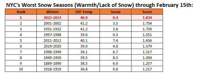
New York City's snow season futility rankings through February 15th:
-
I suspect that we'll still see some cold and snowy winters. However, they will become less frequent in the future.
-
Under sparkling sunshine, the temperature soared to springlike levels. Newark saw the mercury reached 70°. Tomorrow will be another unseasonably warm day. However, a shower or thundershower is possible. Temperatures will run generally above to much above normal through the third week of February. Afterward, temperatures could cool during the closing 7 days of the month. That could afford an opportunity for a snowfall in the Mid-Atlantic region during the February 22-24 timeframe. More than likely, any snowfall would be modest. At this timeframe, a snowfall is not a guaranteed outcome. No severe shots of cold appear likely through February. Among the extended range scenarios on the table is a late February-early March 2002-type outcome. Under such a scenario, cold air would flood into the Plains States, but persistent southeast ridging would keep most of the cold away from the northeastern and Mid-Atlantic United States. During February 28-March 5, 2002 high temperatures in the New York City area generally reached the lower to middle 40s with low temperatures in the 20s at night. At the height of the cold, one night saw the temperature fall into the upper teens. By March 7, the cold was gone and readings return to much above normal levels. The ENSO Region 1+2 anomaly was +0.7°C and the Region 3.4 anomaly was -0.5°C for the week centered around February 8. For the past six weeks, the ENSO Region 1+2 anomaly has averaged -0.12°C and the ENSO Region 3.4 anomaly has averaged -0.62°C. La Niña conditions fading and they should evolve to neutral conditions during late winter or early spring. The SOI was +19.93 today. The preliminary Arctic Oscillation (AO) was +0.841 today. On February 13 the MJO was in Phase 6 at an amplitude of 2.519 (RMM). The February 12-adjusted amplitude was 2.346 (RMM). Based on sensitivity analysis applied to the latest guidance, there is an implied 96% probability that New York City will have a warmer than normal February (1991-2020 normal). February will likely finish with a mean temperature near 40.4° (4.5° above normal).


