donsutherland1
-
Posts
24,192 -
Joined
Content Type
Profiles
Blogs
Forums
American Weather
Media Demo
Store
Gallery
Everything posted by donsutherland1
-
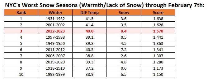
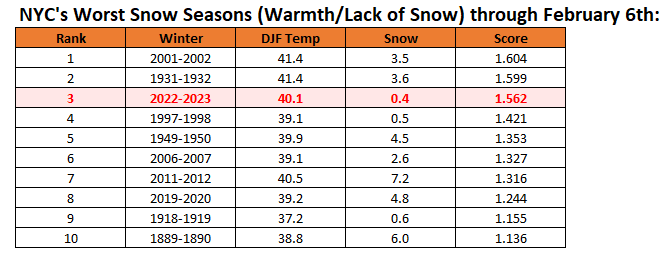
New York City's snow season futility rankings through February 7th:
-
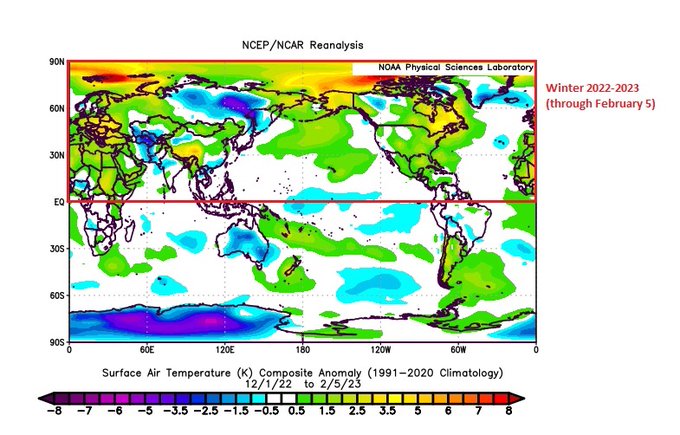
It was a two day severe Arctic shot in an unseasonably warm winter. The coming warmth will wipe out February’s cool anomalies in the region. And a map showing the sad tale of this winter in much of the Northern Hemisphere:
-
It will be mostly cloudy tonight. A few places could see a shower. The clouds and possible shower will be the result of a warm front's moving across the region. In the wake of the frontal passage, tomorrow will be noticeably milder. Generally above normal and much above normal temperatures will continue into at least early next week. During the February 10-11 period, there is a chance that a storm could bring some frozen precipitation to interior areas. Model uncertainty has decreased during the most recent cycles. The potential exists for temperatures to run generally above to much above normal through mid-month. Both the CFSv2 and EPS weeklies show much above normal temperatures through the second week of February. Afterward, temperatures could cool during the closing 7-10 days of the month. There is disagreement among the ensembles about whether it will turn colder for a sustained period or just briefly. In terms of ENSO, the ENSO Region 1+2 anomaly went positive for the week centered around February 1st. That is the first positive reading since a +0.2 anomaly during the week centered around October 6, 2021. The ENSO Region 1+2 anomaly was +0.1°C and the Region 3.4 anomaly was -0.5°C for the week centered around February 1. For the past six weeks, the ENSO Region 1+2 anomaly has averaged -0.23°C and the ENSO Region 3.4 anomaly has averaged -0.65°C. La Niña conditions are beginning to fade and they should evolve to neutral conditions during late winter or early spring. The SOI was +12.78 today. The preliminary Arctic Oscillation (AO) was +2.247 today. On February 5 the MJO was in Phase 4 at an amplitude of 1.800 (RMM). The February 4-adjusted amplitude was 1.674 (RMM). Based on sensitivity analysis applied to the latest guidance, there is an implied 80% probability that New York City will have a warmer than normal February (1991-2020 normal). February will likely finish with a mean temperature near 39.0° (3.1° above normal).
-
Yes. That is true. The standard deviation for seasonal snowfall has increased markedly from 12.9" (1964-93) to 22.5" (1994-2022).
-
That's not the "horse race" I wanted to be witnessing.
-
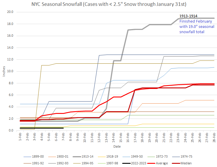
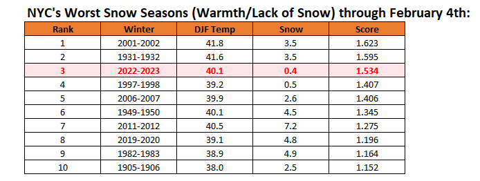
1913-1914 didn't only have the March blizzard, which dumped 14.5" of snow in New York City. It was a much colder winter than the current one. The December-February mean temperature was 32.1°. This winter is extremely likely to finish with a mean temperature of 39.0° or above and possibly 40.0° or above (average through February 6: 40.1°). Since 1869, there have been 8 winters with a December-February mean temperature of 39° or above. Five (62.5%) had seasonal snowfall less than 10". 2 (25%) had seasonal snowfall of 30" or more: 2015-16: 32.8"; 2016-17: 30.8". Both those winters had 10" or more seasonal snowfall through February 7th and 20" or more through February 15th. Of the winters referenced by @bluewave, a breakdown of seasonal snowfall through February 15th and final seasonal snowfall is below: February 15: < 4" Seasonal Snowfall: 1899-1900: 1.1", Final: 13.6" 1900-1901: 3.1", Final: 5.1" 1918-1919: 0.8", Final: 3.8" 1972-1973: 1.8", Final: 2.8" 1997-1998: 0.5", Final: 5.5" February 15: 4" or more Seasonal Snowfall: 1905-1906: 8.5", Final: 20.0" 1913-1914: 11.8", Final: 40.5" 2006-2007: 4.6", Final: 12.4"
-
From the Scafetta paper (2007) referenced in the 'alternative forum' via a Forbes opinion piece: ...we show that the temperature may not significantly increase during the next 30 years mostly because of the negative phase of the 60-year cycle. That paper's conclusion is already badly off course. The warming has accelerated. GISS Global Land and Ocean Temperature Anomalies: 1880: -0.16°C 2007: +0.66°C (year of paper used to denote the start of the referenced 30-year period) Change: Approximately 0.06°C/decade 2007: +0.66°C (year of paper used to denote the start of the referenced 30-year period) 2022: +0.89°C (after two years of La Niña; the average anomaly during 2010-2022 was +0.82°C) Change: Approximately 0.15°/decade (nearly 2.4 times the rate of warming during 1880-2007) The increased rate of warming is consistent with the observed increased energy imbalance produced by the rising atmospheric concentration of greenhouse gases. The physics is sound (basic understanding dates back to the 19th century). Efforts to find workarounds to deviate from the laws of physics and their implications, namely the impact of increased greenhouse gas forcing, are futile as shown in the rapid breakdown of the Scafetta hypothesis.
-
Morning thoughts… Today will be variably cloudy and seasonably cool. High temperatures will reach the lower and middle 40s in most areas. Likely high temperatures around the region include: New York City (Central Park): 41° Newark: 44° Philadelphia: 47° Milder air will return tomorrow. Normals: New York City: 30-Year: 40.7°; 15-Year: 40.8° Newark: 30-Year: 41.4°; 15-Year: 41.5° Philadelphia: 30-Year: 42.6°; 15-Year: 42.5°
-
New York City's snow season futility rankings through February 6th:
-
These are complex events. Much could go wrong. If the vortex splits, the larger piece could wind up in Eurasia. If there is no stratosphere-troposphere coupling, the desired colder outcome might not occur. I think we’ll have to wait to see how things actually evolve. I hope things work out.
-
Blustery winds are pushing a colder air mass into the region. Once again, as has been the theme this winter, the cold won't last long. Generally above normal and much above normal temperatures will continue into at least early next week. During the February 10-11 period, there is a chance that a storm could bring some frozen precipitation to interior areas. There remains a large amount of uncertainty. The potential exists for temperatures to run generally above to much above normal through mid-month. Both the CFSv2 and EPS weeklies show much above normal temperatures through the second week of February. Afterward, temperatures could cool during the closing 7-10 days of the month. There is disagreement among the ensembles about whether it will turn colder for a sustained period or just briefly. In terms of ENSO, the ENSO Region 1+2 anomaly went positive for the week centered around February 1st. That is the first positive reading since a +0.2 anomaly during the week centered around October 6, 2021. The ENSO Region 1+2 anomaly was +0.1°C and the Region 3.4 anomaly was -0.5°C for the week centered around February 1. For the past six weeks, the ENSO Region 1+2 anomaly has averaged -0.23°C and the ENSO Region 3.4 anomaly has averaged -0.65°C. La Niña conditions are beginning to fade and they should evolve to neutral conditions during late winter or early spring. The SOI was +10.81 today. The preliminary Arctic Oscillation (AO) was +1.602 today. On February 4 the MJO was in Phase 3 at an amplitude of 1.671 (RMM). The February 3-adjusted amplitude was 1.560 (RMM).
-
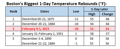
Yesterday's 61-degree rebound from Saturday's low temperature was the 3rd biggest such change on record for Boston.
-
Morning thoughts… Today will be partly sunny and mild. High temperatures will reach the upper 40s and lower 50s in most areas. Likely high temperatures around the region include: New York City (Central Park): 49° Newark: 51° Philadelphia: 51° It will be briefly cooler tomorrow before much milder air returns. Normals: New York City: 30-Year: 40.6°; 15-Year: 40.6° Newark: 30-Year: 41.2°; 15-Year: 41.4° Philadelphia: 30-Year: 42.4°; 15-Year: 42.4°
-
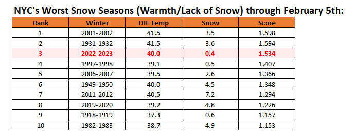
New York City's snow season futility rankings through February 5th:
-
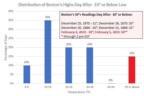
The short-lived Arctic blast is now a rapidly fading memory. Temperatures surged into the upper 40s and even lower 50s this afternoon. At Boston, the temperature soared to 51° following yesterday's -10° reading. That is the third 50° or warmer day following a -10° or below temperature. Those days are: December 21, 1875: 55° (December 20, 1875: -11°) December 21, 1875: 54° (December 20, 1884: -10°) February 5, 2023: 51° (February 4, 2023: -10°) Generally above normal and much above normal temperatures will continue into at least early next week. During the February 10-11 period, there is a chance that a storm could bring some frozen precipitation to interior areas. The potential exists for temperatures to run generally above to much above normal through mid-month. Both the CFSv2 and EPS weeklies show much above normal temperatures through the second week of February. Afterward, there is disagreement among the ensembles about whether it turns colder for a sustained period or just briefly. The ENSO Region 1+2 anomaly was -0.2°C and the Region 3.4 anomaly was -0.6°C for the week centered around January 25. For the past six weeks, the ENSO Region 1+2 anomaly has averaged -0.32°C and the ENSO Region 3.4 anomaly has averaged -0.70°C. La Niña conditions are beginning to fade and they should evolve to neutral conditions during late winter or early spring. The SOI was +16.57 today. The preliminary Arctic Oscillation (AO) was +0.087 today. On February 3 the MJO was in Phase 3 at an amplitude of 1.556 (RMM). The February 2-adjusted amplitude was 1.645 (RMM).
-
Final warnings usually occur March-May. The earliest was in 2016 (near the start of March). It’s too soon to be sure what lies ahead.
-
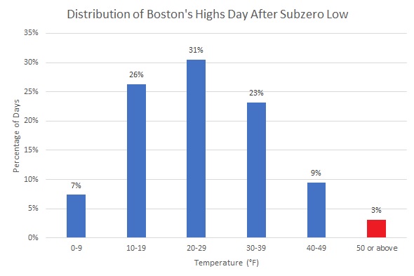
At 2 pm EST, Boston had a temperature of 50°. That comes a day after Boston's -10° temperature. This is the 3rd case on record where the temperature reached 50° or above following a low of -10° or below and 6th such temperature a day after a subzero low.
-
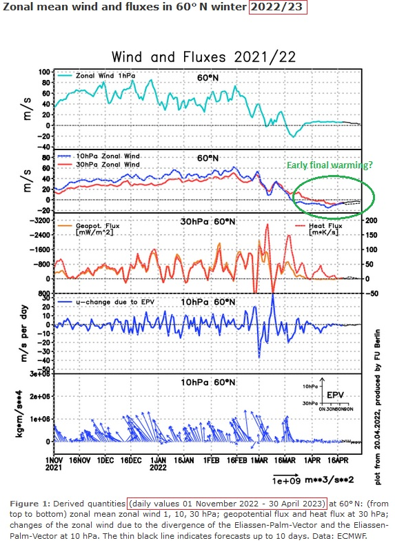
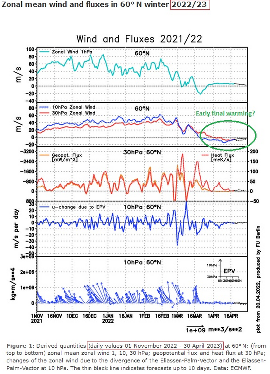
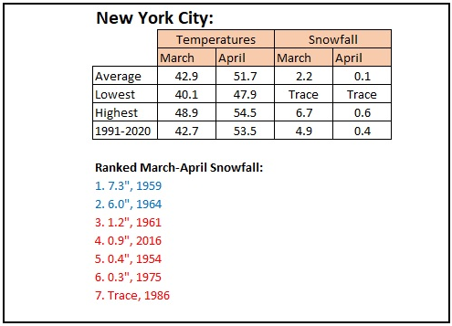
The Internet is again abuzz with long-range guidance showing a potential stratospheric warming event. What follows is speculation about a cold and possible snowy March. The usual caveats about model skill at extended ranges and the poorly-understood nature of such events applies. But if one looks at the excellent FU-Berlin site, one finds something that is not being mentioned. The long-range guidance isn't hinting at just an ordinary SSW event, but suggesting an early final warming event. Although there are erroneous date labels on the chart (showing 2021-2022 in places, the chart is for 2022-2023). From 1950-2020, there have been 7 early final stratospheric warming events (occurring prior to day 80 in the year): 1954, 1959, 1961, 1964, 1975, 1986, and 2016. The outcomes for March and April are mixed. 1975 had nationwide cold during March. 2016 had nationwide warmth during March. 1954 had near nationwide warmth during April. 1975 had near nationwide cold during April. For New York City, 5/7 (71%) had much below normal March-April two-month snowfall.
-
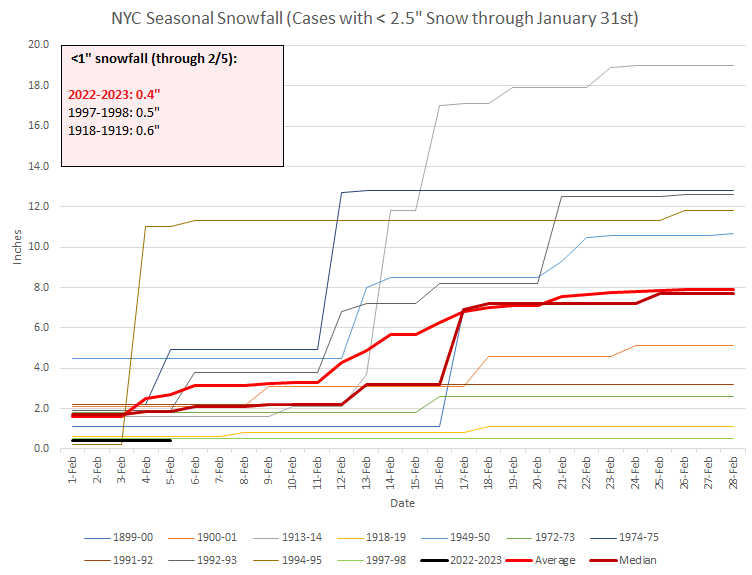
With no snow expected today, Winter 2022-2023 is just one of three winters will have seen less than 1" of snow through February 5th. Both prior winters had little or snowfall through all of February. Some other winters that ended January with less than 2.5" of snow wound up with snowy outcomes in February.
-
New York City's snow season futility rankings through February 4th:
-
Yes, NYC was in the single digits on February 4-5, 1996.
-
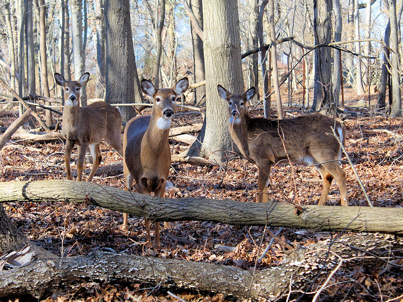
Thanks. They were wary at first and even approached for a closer look at the camera.
-
The Northeast saw near record and record cold temperatures this morning, as a fierce Arctic air mass moved through the region. That air mass is now rapidly departing. Daily records included: Binghamton: -13° (old record: -4°, 1996) Boston: -10° (old record:-2°, 1886) Bridgeport: -4° (old record: 5°, 1955 and 1996) Hartford: -9° (old record: -8°, 1965) Montreal: -21° (old record: -20°, 1963) Mount Washington, NH: -47° (old record: -35°, 1963) ***new monthly and state monthly record*** New Haven: -3° (old record: 4°, 1963 and 2011) New York City-JFK: 4° (old record: 9°, 1955 nd 1996) New York City-LGA: 5° (old record: 10°, 1955, 1963, 1978 and 1996) Newark: 5° (old record: 7°, 1985 and 1996) Ottawa: -26° (old record: -22°, 1948) Providence: -9° (old record: -2°, 1918) Rivière-du-Loup, QC: -22° (old record: -19°, 1996) Quebec City: -25° (old record: -21°, 1996) Sherbrooke, QC: -24° (old record: -6°, 2009) Trois-Rivières, QC: -25° (old record: -20°, 1996) White Plains: 1° (old record: 4°, 1978) Worcester: -13° (old record: -4°, 1908, 1918, and 1934) Yarmouth, NS: -7° (old record: -2°, 1967) As had been the case during the December Arctic shot in a winter of almost unbroken warmth, the current Arctic shot responsible for the near record and record cold will be a fleeting one. The temperature will rocket toward normal levels and then above normal levels tomorrow. Above normal temperatures will continue through Friday. The potential exists for temperatures to run generally above to much above normal through mid-month. Both the CFSv2 and EPS weeklies show much above normal temperatures through the second week of February. A storm could impact the region during February 10-11 if some of the guidance is right. The ENSO Region 1+2 anomaly was -0.2°C and the Region 3.4 anomaly was -0.6°C for the week centered around January 25. For the past six weeks, the ENSO Region 1+2 anomaly has averaged -0.32°C and the ENSO Region 3.4 anomaly has averaged -0.70°C. La Niña conditions are beginning to fade and they should evolve to neutral conditions during late winter or early spring. The SOI was +19.41 today. The preliminary Arctic Oscillation (AO) was -0.463 today. On February 2 the MJO was in Phase 3 at an amplitude of 1.644 (RMM). The February 1-adjusted amplitude was 1.666 (RMM).
-
I hope we can get some snow.
-
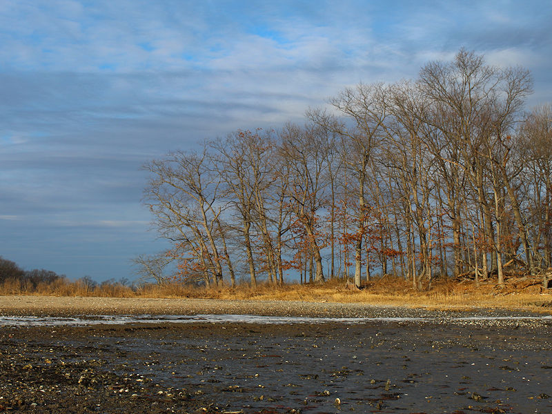
As milder air pressed northward into a rapidly retreating Arctic air mass, the sky was filled with high and mid-level clouds. The mercury slowly clawed its way back from the single digits, climbing through the teens, and into the 20s. Two photos.