donsutherland1
-
Posts
24,192 -
Joined
Content Type
Profiles
Blogs
Forums
American Weather
Media Demo
Store
Gallery
Everything posted by donsutherland1
-
Yes. 1912-13: 11.4” December; 2.9” January-February.
-
Winters with less than 1" snowfall in December and < 3" total in January-February: 1918-1919, 1931-1932, 1972-1973, 1991-1992, 1997-1998 2001-02 had a trace of snow in December and 3.5" in January-February (nothing afterward).
-
Yes. That is very likely. The record is 40.6°, which was set in 1990.
-
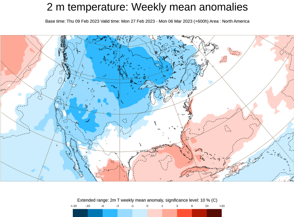
There’s a window of opportunity during 2/22-24. A lot can still change, but at least there’s some guidance with some snowfall. Let’s see where things stand at the end of the week.
-
Morning thoughts… Today will be partly sunny and unseasonably warm. High temperatures will reach the lower and middle 60s in most areas. Likely high temperatures around the region include: New York City (Central Park): 62° Newark: 65° Philadelphia: 65° Unseasonably mild weather will prevail through Friday. Normals: New York City: 30-Year: 42.1°; 15-Year: 42.2° Newark: 30-Year: 43.0°; 15-Year: 43.1° Philadelphia: 30-Year: 44.2°; 15-Year: 44.0°
-
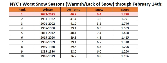
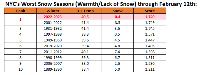
New York City's snow season futility rankings through February 14th. As per the guidance, things could change next week.
-
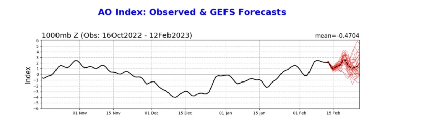
Tomorrow will unseasonably warm. Readings will likely reach the lower and even middle 60s across the Mid-Atlantic region. Temperatures will run generally above to much above normal through the third week of February. Afterward, temperatures could cool during the closing 7 days of the month. That could afford an opportunity for a rare (for this winter) snowfall in the Mid-Atlantic region during the February 22-24 timeframe. More than likely, any snowfall would be modest. No severe shots of cold appear likely through February. Among the extended range scenarios on the table is a late February-early March 2002-type outcome. Under such a scenario, cold air would flood into the Plains States, but persistent southeast ridging would keep most of the cold away from the northeastern and Mid-Atlantic United States. During February 28-March 5, 2002 high temperatures in the New York City area generally reached the lower to middle 40s with low temperatures in the 20s at night. At the height of the cold, one night saw the temperature fall into the upper teens. By March 7, the cold was gone and readings return to much above normal levels. The ENSO Region 1+2 anomaly was +0.7°C and the Region 3.4 anomaly was -0.5°C for the week centered around February 8. For the past six weeks, the ENSO Region 1+2 anomaly has averaged -0.12°C and the ENSO Region 3.4 anomaly has averaged -0.62°C. La Niña conditions fading and they should evolve to neutral conditions during late winter or early spring. The SOI was +15.23 today. The preliminary Arctic Oscillation (AO) was +1.259 today. On February 12 the MJO was in Phase 6 at an amplitude of 2.342 (RMM). The February 11-adjusted amplitude was 2.076 (RMM). Based on sensitivity analysis applied to the latest guidance, there is an implied 97% probability that New York City will have a warmer than normal February (1991-2020 normal). February will likely finish with a mean temperature near 40.6° (4.7° above normal).
-
Morning thoughts… Today will be mostly sunny and mild. High temperatures will reach the lower and middle 50s in most areas. Likely high temperatures around the region include: New York City (Central Park): 54° Newark: 55° Philadelphia: 55° Unseasonably mild weather will prevail through Friday. Normals: New York City: 30-Year: 42.0°; 15-Year: 42.0° Newark: 30-Year: 42.7°; 15-Year: 42.8° Philadelphia: 30-Year: 44.0°; 15-Year: 43.8°
-
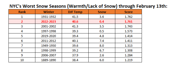
New York City's snow season futility rankings through February 13th:
-
Yes, the NAM is the AO.
-
I also am cautious given the sample size involved. However, even if one sees a big drop in the AO/NAO within 45 days, we’ll be in mid- to late-March. It will be interesting to see what actually happens.
-
Yes, that’s true. With shortening wave lengths, a PNA- is no longer the problem it was earlier in the winter. Hopefully, the NAO can help suppress the SE ridge.
-
Thank you for sharing this link. I will have a look at it.
-
Under brilliant sunshine, today featured more of the springlike warmth that has defined much of the winter. Temperatures generally ranged from the middle 50s to the lower 60s. At JFK Airport, the temperature reached 56°, which broke the old record of 54°, which was set in 1949. Islip saw a high temperature of 56°, which tied the record set in 2008. Tomorrow will be somewhat cooler but still warmer than normal. Temperatures will rebound strongly on Wednesday. Temperatures will run generally above to much above normal through the third week of February. Afterward, temperatures could cool during the closing 7 days of the month. However, no severe shots of cold appear likely into late February. Among the extended range scenarios on the table is a late February-early March 2002-type outcome. Under such a scenario, cold air would flood into the Plains States, but persistent southeast ridging would keep most of the cold away from the northeastern and Mid-Atlantic United States. During February 28-March 5, 2002 high temperatures in the New York City area generally reached the lower to middle 40s with low temperatures in the 20s at night. At the height of the cold, one night saw the temperature fall into the upper teens. By March 7, the cold was gone and readings return to much above normal levels. The ENSO Region 1+2 anomaly was +0.7°C and the Region 3.4 anomaly was -0.5°C for the week centered around February 8. For the past six weeks, the ENSO Region 1+2 anomaly has averaged -0.12°C and the ENSO Region 3.4 anomaly has averaged -0.62°C. La Niña conditions fading and they should evolve to neutral conditions during late winter or early spring. The SOI was +13.45 today. The preliminary Arctic Oscillation (AO) was +2.045 today. On February 11 the MJO was in Phase 5 at an amplitude of 2.068 (RMM). The February 10-adjusted amplitude was 2.075 (RMM). Based on sensitivity analysis applied to the latest guidance, there is an implied 97% probability that New York City will have a warmer than normal February (1991-2020 normal). February will likely finish with a mean temperature near 40.7° (4.8° above normal).
-
Yes. It is disappointing.
-
This is probably the coldest period shown on the latest ECMWF weeklies: Last week:
-
If such descriptions are accurate, a spectacular bust is probably the most likely outcome. Such an extreme outcome is extremely unlikely to verify. Keeping in mind low model skill at extended timeframes, none of the long-range guidance (ECWMF weeklies or CFSv2) has anything close to such an outcome. We'll see if the ECMWF weeklies change when they are posted later today. For perspective, the average temperature during March 1-April 15, 1991-2020 in New York City is 45.4°. The last time NYC had a mean temperature at least 5° below that figure was in 1960. That occurred during a colder climate regime (the 1951-1980 average temperature for March 1-April 15 was 43.9°). The last time, NYC saw 20" or more snow during that period occurred in 1956 (also the last year with a -5° anomaly/20" or more snowfall during March 1-April 15). Before that, the last such combination of snow and cold occurred in 1916. Overall, since 1869, New York City has seen just 6 years with such a combination of snowfall and cold (temperature anomaly of 5° or more below normal) during March 1-April 15: 1875, 1888, 1896, 1914, 1916, and 1956. None of those winters saw the kind of warmth the current winter has had. The warmest was 1955-1956 with a mean temperature of 35.5°. None of them featured the exceptionally low snowfall that has occurred though February 12th. 1914 had 2.1" but with a winter mean temperature of 33.9°. 1956 had 5.5" with a winter mean temperature of 35.5°. The figures through February 12, 2023 are 0.4" and 40.5° respectively. All said, the latest weekly guidance (the CFSv2 stays warm through the March 6-12 period; last week's ECMWF weeklies brought readings to near normal to close February and start March), the warming that has occurred since the 1950s and 1960s (though JB likely dismisses this factor outright given his stance on climate change despite both the data and science--that creates a large and growing blind spot in his forecasting), and NYC's historic statistics all suggest that there is only a very low probability of such an outcome. Finally, why might he issue such an extreme forecast that appears to have very little probability of verifying? It may well have to do with the fact that he has not fared well this winter. His winter forecasts have essentially burned up in the unrelenting torches of non-winter 2022-2023. He had called for a severely cold and snowy winter in Europe, adding political commentary that Europe would face major energy shortages driven by its energy policies. He also called for the "hounds of winter" to "howl" during January 10-30 (with posted maps of past Arctic outbreaks), invoked the March 1993/January 1996 storms in December and January 1996/2016 storms in January as "analogs." Against this backdrop, his described forecast seems to be one last desperate swing for the proverbial fences. It is sad how far he has fallen. His forecasts have been increasingly and adversely impacted by his deepening spiral into climate change denial, political considerations, and even conspiracy theories.
-
Morning thoughts… Today will become mostly sunny. It will be very mild. High temperatures will reach the middle and upper 50s in most areas. Likely high temperatures around the region include: New York City (Central Park): 55° Newark: 58° Philadelphia: 59° Unseasonably mild weather will prevail through Friday. Normals: New York City: 30-Year: 41.8°; 15-Year: 41.8° Newark: 30-Year: 42.5°; 15-Year: 42.6° Philadelphia: 30-Year: 43.8°; 15-Year: 43.6°
-
New York City's snow season futility rankings through February 12th:
-
Yes, it is early. Skill scores at that range are low. A lot can still change between now and then.
-
I came up with it. It’s the standard deviation departure of the mean winter temperature from the historic average (period of record) - the standard deviation departure of snowfall to date from the historic average.
-
Tonight will be mainly cloudy. Some showers are possible, especially south and east of New York City. In the wake of the storm that is passing well to our south and east, much milder air will return to the region tomorrow. Clouds will yield to sunshine. The potential exists for temperatures to run generally above to much above normal through the third week of February. Afterward, temperatures could cool during the closing 7 days of the month. However, no severe shots of cold appear likely into late February. Among the extended range scenarios on the table is a late February-early March 2002-type outcome. Under such a scenario, cold air would flood into the Plains States, but persistent southeast ridging would keep most of the cold away from the northeastern and Mid-Atlantic United States. During February 28-March 5, 2002 high temperatures in the New York City area generally reached the lower to middle 40s with low temperatures in the 20s at night. At the height of the cold, one night saw the temperature fall into the upper teens. By March 7, the cold was gone and readings return to much above normal levels. In terms of ENSO, the ENSO Region 1+2 anomaly went positive for the week centered around February 1st. That is the first positive reading since a +0.2 anomaly during the week centered around October 6, 2021. The ENSO Region 1+2 anomaly was +0.1°C and the Region 3.4 anomaly was -0.5°C for the week centered around February 1. For the past six weeks, the ENSO Region 1+2 anomaly has averaged -0.23°C and the ENSO Region 3.4 anomaly has averaged -0.65°C. La Niña conditions are beginning to fade and they should evolve to neutral conditions during late winter or early spring. The SOI was +15.90 today. The preliminary Arctic Oscillation (AO) was +1.986 today. On February 9 the MJO was in Phase 5 at an amplitude of 2.057 (RMM). The February 8-adjusted amplitude was 1.961 (RMM). Based on sensitivity analysis applied to the latest guidance, there is an implied 96% probability that New York City will have a warmer than normal February (1991-2020 normal). February will likely finish with a mean temperature near 40.6° (4.7° above normal).
-
Not exactly what one would like to see following a SSW event.
-
Morning thoughts… Today will become mostly cloudy after some sunshine. Some light rain is possible later in the day and tonight, especially south and east of New York City. High temperatures will reach the middle 40s in most areas. Likely high temperatures around the region include: New York City (Central Park): 46° Newark: 47° Philadelphia: 47° Unseasonably mild weather will prevail through Friday. Normals: New York City: 30-Year: 41.6°; 15-Year: 41.6° Newark: 30-Year: 42.3°; 15-Year: 42.4° Philadelphia: 30-Year: 43.6°; 15-Year: 43.4°
-
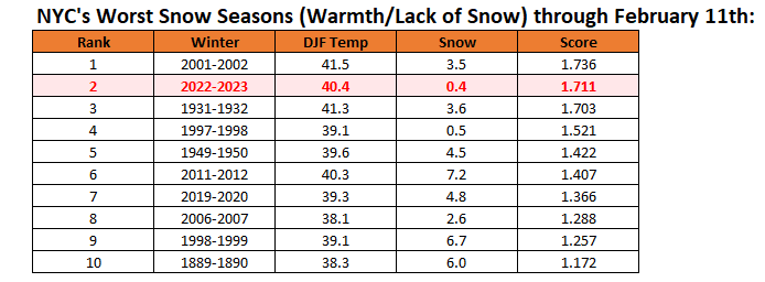
New York City's snow season futility rankings through February 11th: