donsutherland1
-
Posts
24,192 -
Joined
Content Type
Profiles
Blogs
Forums
American Weather
Media Demo
Store
Gallery
Everything posted by donsutherland1
-
With a mean temperature of 76.1, it was the hottest summer until 1906. Its 11 90-degree days in July stood as the monthly record until it was broken in July 1940 (12 days). That record was tied in July 1934 and August 1939. Its highest temperature was 98.
-
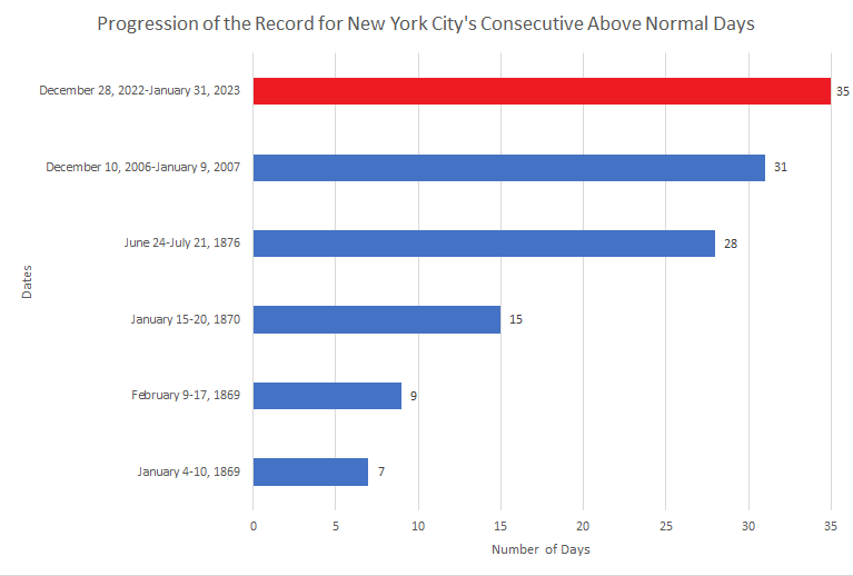
Progression of New York City's record streaks of above normal days:
-
NYC and LGA both reached 50. So far, JFK and NYC have no measurable snow. That might change tonight.
-
Bridgeport, Islip, New York City (Central Park, JFK Airport, and LaGuardia Airport), and Newark are concluding their warmest January on record. Nevertheless, colder air began pressing into the region before sunsrise today, accompanied by rain, sleet, and snow showers. Parts of the region picked up a few tenths of an inch of snow, but not Central Park. As a result, Central Park's measurable snow drought has now reached 328 days, which ranks as the second longest such stretch on record. Overnight into tomorrow morning, a weak disturbance passing to the south of the region could bring a period of light snow to parts of the area, especially south and east of New York City. There is a possibility that New York City could pick up a few tenths of an inch of snow bringing an end to the measurable snow drought. That outcome is not assured. In the wake of the system, a near seasonably cold day will follow. A cooler than normal first week of February in what will likely be a warmer than normal month overall now lies ahead. The developing cool period will be highlighted by a brief Arctic blast. Saturday could be the coldest day with the temperature rising only into the upper teens and lower 20s during the daytime after a morning low in the single digits in New York City and possibly below zero outside the City. Afterward, moderation will rapidly commence. The potential exists for temperatures to run above to much above normal through mid-month. Both the CFSv2 and EPS weeklies show much above normal temperatures for the second week of February. The ENSO Region 1+2 anomaly was -0.2°C and the Region 3.4 anomaly was -0.6°C for the week centered around January 25. For the past six weeks, the ENSO Region 1+2 anomaly has averaged -0.32°C and the ENSO Region 3.4 anomaly has averaged -0.70°C. La Niña conditions are beginning to fade and they should evolve to neutral conditions during late winter or early spring. The SOI was +6.22 today. The preliminary Arctic Oscillation (AO) was +1.476 today. On January 29 the MJO was in Phase 3 at an amplitude of 2.458 (RMM). The January 28-adjusted amplitude was 2.312 (RMM).
-
Yes. Let’s see if we can get a little snow. It should be colder and easier to stick.
-
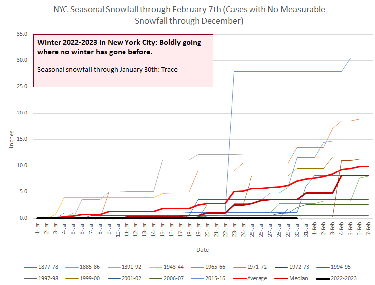
Central Park: Trace The Park's wait for measurable snow goes on.
-
The story of our winter so far... From the NWS: The arctic cold front slips through Friday morning. There are some differences in the timing, but all bring in the coldest air Friday night with 85h temps dropping to around -25C and in some cases approaching -30C. With no downstream block over the north Atlantic, this will be a fleeting airmass, in and out as fast as it came in. In addition, with strong NW winds behind the cold front, gusts of 25 to 35 mph will produce wind chills at the very least at advisory criteria with a small chance of reaching warning levels inland. Lows Friday night inland are forecast to drop several degrees below zero with the single digits at the coast. For highs Saturday, most locations will be in the teens.
-
The MJO is at its highest amplitude this winter. How long that will last remains to be seen. If it persists, it might play more of a role than it has so far.
-
DCA _ NYC _ BOS __ ORD _ ATL _ IAH ___ DEN _ PHX _ SEA 2.5 2.0 1.7 1.0 3.5 1.5 -1.0 -2.3 -1.6
-
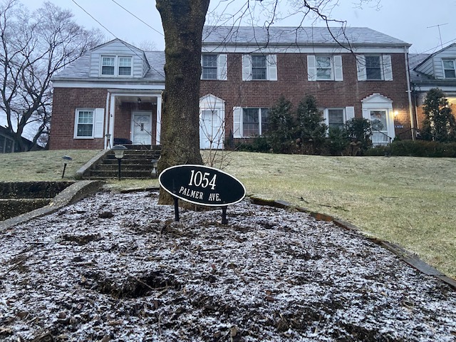
The snow is starting to stick in Larchmont.
-
There is light sleet in Larchmont.
-
2022-23 would move into the lead if they are right. The final standings would depend on how much snow falls in March and April.
-
Morning thoughts… Early showers of rain, sleet, and snow will give way to variably cloudy skies. It will be noticeably cooler than yesterday. High temperatures will reach the upper 30s and lower 40s in most areas. Likely high temperatures around the region include: New York City (Central Park): 40° Newark: 42° Philadelphia: 41° A short but sharp Arctic blast is likely toward the end of the week. Normals: New York City: 30-Year: 39.8°; 15-Year: 40.0° Newark: 30-Year: 40.3°; 15-Year: 40.7°
-
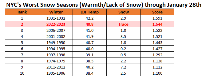
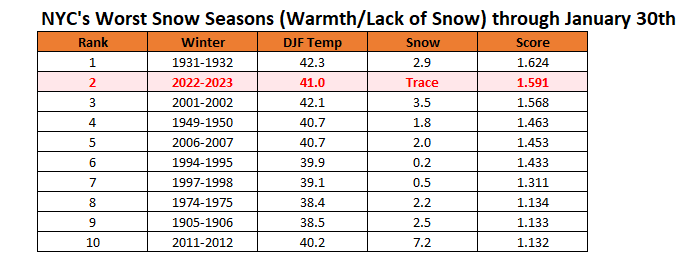
New York City's snow season futility rankings through January 30th.
-
It was at least 49° early this morning.
-
15 in 1950. Two years had 14.
-
Yes. That’s going to assure that this will be the warmest January on record.
-
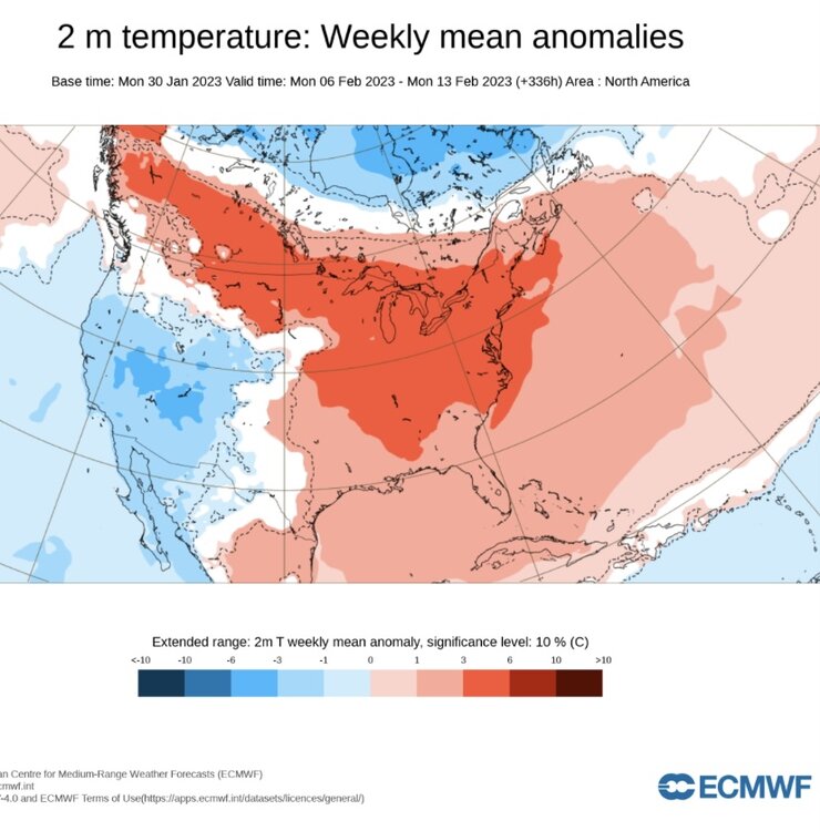
After the short-lived Arctic blast (February 3-4), much of the eastern half of North America will again turn much warmer than normal.
-
That would tie for 4th.
-
With temperatures soaring into the middle 50s, today was New York City's 34th consecutive warmer than normal day. That extended the ongoing record. The prior record of 31 days was set during December 10, 2006 through January 9, 2007. New York City also registered its 11th 40° or above low temperature of the month. That surpassed the old January mark of 10 days, which was set in 1932. Colder air will begin to return to the region late tomorrow. Winter 2022-2023 has now surpassed the record for latest first measurable snowfall in New York City. The old record of January 29th was set in 1973. It is likely that New York City will get through all of January without a measurable snowfall. The developing cooler pattern will last through the week. That pattern will be highlighted by a brief Arctic blast. Saturday could be the coldest day with the temperature rising only into the upper teens and lower 20s during the daytime after a morning low in the single digits in New York City and possibly below zero outside the City. The onset of this cooler period might afford some opportunities for snowfall, but a snowy outcome remains far from certain. Afterward, moderation will likely commence during the second week of the month. The ENSO Region 1+2 anomaly was -0.2°C and the Region 3.4 anomaly was -0.6°C for the week centered around January 25. For the past six weeks, the ENSO Region 1+2 anomaly has averaged -0.32°C and the ENSO Region 3.4 anomaly has averaged -0.70°C. La Niña conditions are beginning to fade and they should evolve to neutral conditions during late winter or early spring. The SOI was +2.78 today. The preliminary Arctic Oscillation (AO) was +1.472 today. On January 28 the MJO was in Phase 3 at an amplitude of 2.299 (RMM). The January 27-adjusted amplitude was 2.067 (RMM). Based on sensitivity analysis applied to the latest guidance, there is an implied near 100% probability that New York City will have a warmer than normal January (1991-2020 normal). January will likely finish with a mean temperature near 43.4° (9.7° above normal). That will make January 2023 the warmest January on record, breaking the record of 43.2°, which was set in January 1932.
-
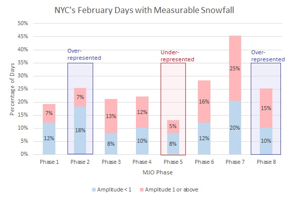
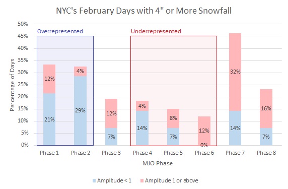
New York City's February snowfall data by MJO Phase. Underrepresented means that the percentage of days for an MJO phase is less than 80% of climatology; overrepresented means that the percentage of days for an MJO phase is more than 120% of climatology.
-
With the overnight guidance showing a slightly slower arrival of the cooler air tomorrow, the probability that NYC will see its warmest January on record has increased.
-
Morning thoughts… Today will be partly to mostly cloudy and very mild. High temperatures will reach the upper 40s and lower 50s in most areas. Likely high temperatures around the region include: New York City (Central Park): 51° Newark: 53° Philadelphia: 55° Cooler air will return tomorrow. A short Arctic blast is likely toward the end of the week. Normals: New York City: 30-Year: 39.7°; 15-Year: 39.9° Newark: 30-Year: 40.2°; 15-Year: 40.6° Philadelphia: 30-Year: 41.5°; 15-Year: 41.7°
-
New York City's snow season futility rankings through January 29th: