donsutherland1
-
Posts
24,192 -
Joined
Content Type
Profiles
Blogs
Forums
American Weather
Media Demo
Store
Gallery
Everything posted by donsutherland1
-
Today saw mild readings in the middle and upper 40s across the region. Newark topped out at 50°. A storm will bring snow rapidly changing to rain across the region tomorrow. New York City will see little or no accumulation, as recent guidance has backed off measurable amounts. The 18z GFS still shows a small measurable snowfall. The distant northern and western suburbs are in line for 1-3" of snow. A cooler pattern will move in during the first week of February and last through the week. Afterward, moderation could begin to occur during the second week of the month. The ENSO Region 1+2 anomaly was -0.3°C and the Region 3.4 anomaly was -0.6°C for the week centered around January 11. For the past six weeks, the ENSO Region 1+2 anomaly has averaged -0.30°C and the ENSO Region 3.4 anomaly has averaged -0.75°C. La Niña conditions are beginning to fade and they should evolve to neutral conditions during late winter or early spring. The SOI was +16.96 today. The preliminary Arctic Oscillation (AO) was +0.254 today. This was the first positive AO reading since November 22, 2022 when the AO was +0.064. On January 22 the MJO was in Phase 3 at an amplitude of 1.523 (RMM). The January 21-adjusted amplitude was 1.608 (RMM). Based on sensitivity analysis applied to the latest guidance, there is an implied near 100% probability that New York City will have a warmer than normal January (1991-2020 normal). January will likely finish with a mean temperature near 41.8° (8.1° above normal).
-
In the wake of today's storm, tomorrow will be partly sunny and still mild. The respite from precipitation won't last long. New York City's long measurable snow drought will very likely end on Wednesday as a storm brings accumulating snow changing to rain to New York City. A general 1" or less snowfall appears likely in and around New York City with 1"-3" likely in the far northern and western suburbs. A cooler pattern will move in during the first week of February and last through the week. Afterward, moderation could begin to occur. The ENSO Region 1+2 anomaly was -0.3°C and the Region 3.4 anomaly was -0.6°C for the week centered around January 11. For the past six weeks, the ENSO Region 1+2 anomaly has averaged -0.30°C and the ENSO Region 3.4 anomaly has averaged -0.75°C. La Niña conditions are beginning to fade and they should evolve to neutral conditions during late winter or early spring. The SOI was +13.20 today. The preliminary Arctic Oscillation (AO) was -0.834 today. On January 21 the MJO was in Phase 3 at an amplitude of 1.608 (RMM). The January 20-adjusted amplitude was 1.173 (RMM). Based on sensitivity analysis applied to the latest guidance, there is an implied near 100% probability that New York City will have a warmer than normal January (1991-2020 normal). January will likely finish with a mean temperature near 41.6° (7.9° above normal).
-
Ensemble members for NYC:
-
Morning thoughts… Light rain or wet snow will end today. High temperatures will reach the lower 40s in most areas. Likely high temperatures around the region include: New York City (Central Park): 41° Newark: 43° Philadelphia: 43° After a dry Tuesday, accumulating snow changing to rain will arrive in New York City on Wednesday. Normals: New York City: 30-Year: 39.2°; 15-Year: 39.7° Newark: 30-Year: 39.7°; 15-Year: 40.4° Philadelphia: 30-Year: 41.0°; 15-Year: 41.5°
-
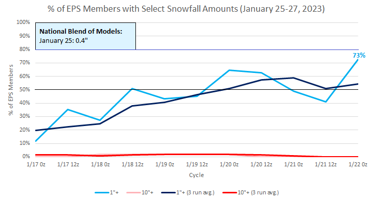
The latest EPS forecast for NYC:
-
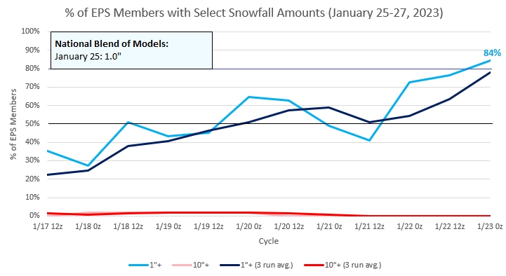
A storm will bring rain to the region tonight into tomorrow. Some sleet is possible at the onset in New York City and Newark. A general 0.50"-1.00" rainfall is likely. A 1"-3" accumulation of snow is possible well north and west of Newark and New York City. There is a small chance that the rain could end as a period of snow in New York City tomorrow with a minor accumulation. New York City's long measurable snow drought will likely end on Wednesday. Support for a measurable snowfall during the January 25-27 period is now moderate-to-high on the ensembles. The National Blend of Models has increased to 0.8" during January 25. A cooler pattern will move in during the first week of February and last through much or all of the first week of February. Afterward, moderation could begin to occur. The ENSO Region 1+2 anomaly was -0.3°C and the Region 3.4 anomaly was -0.2°C for the week centered around January 11. For the past six weeks, the ENSO Region 1+2 anomaly has averaged -0.37°C and the ENSO Region 3.4 anomaly has averaged -0.82°C. La Niña conditions could fade to neutral conditions during late winter or early spring. The SOI was +19.08 today. The preliminary Arctic Oscillation (AO) was -1.098 today. On January 20 the MJO was in Phase 3 at an amplitude of 1.100 (RMM). The January 19-adjusted amplitude was 0.716 (RMM). Based on sensitivity analysis applied to the latest guidance, there is an implied near 100% probability that New York City will have a warmer than normal January (1991-2020 normal). January will likely finish with a mean temperature near 41.5° (7.8° above normal).
-
Just before a rain/sleet mixture moved in.
-
A rain/sleet mixture has moved into southern Westchester County.
-
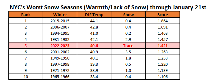
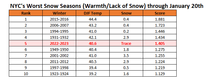
New York City's snow season fultility rankings through January 21st. Winter 2022-2023 will likely fall on this list later this week as the City sees its first measurable snowfall at Central Park on Wednesday.
-
Today will be New York City's (Central Park) 319th consecutive day without measurable snow. That will be tied for the 3rd longest such stretch. However, there is growing ensemble support indicating that this stretch will likely end on January 25th. There remains a low probability that it could end tomorrow if some of the colder guidance is accurate.
-
Morning thoughts… It will be mostly cloudy and mild. Rain will arrive late in the day. North and west of New York City and Newark, set snow and sleet will arrive. High temperatures will reach the lower 40s in most areas. Likely high temperatures around the region include: New York City (Central Park): 42° Newark: 44° Philadelphia: 43° Rain and wet snow will end tomorrow. Normals: New York City: 30-Year: 39.1°; 15-Year: 39.7° Newark: 30-Year: 39.6°; 15-Year: 40.4° Philadelphia: 30-Year: 40.9°; 15-Year: 41.5°
-
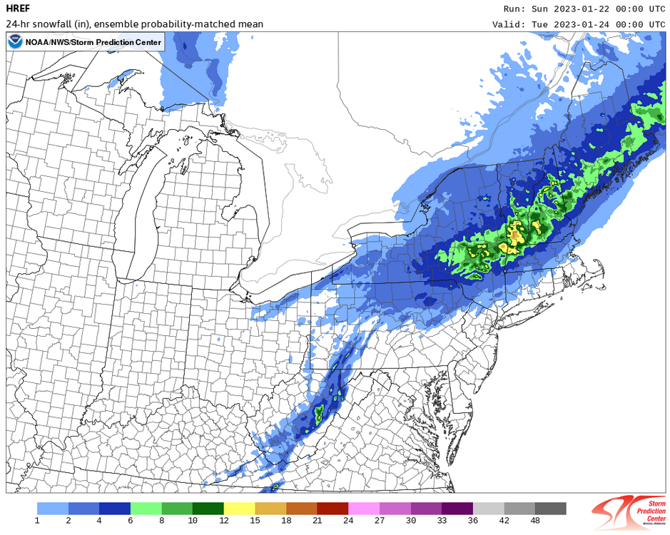
HREF for Monday:
-
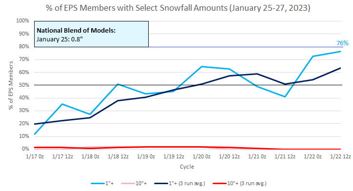
A storm will bring rain to the region later tomorrow into Monday. The precipitation could start as snow north and west of Newark and New York City. The 18z GFS brings a period of accumulating snow to New York City, but it lacks support of the other guidance. Temperatures will remain milder than normal Overall, the lengthening measurable snow drought will persist in New York City and Philadelphia through at least early next week. Support for a measurable snowfall during the January 25-27 period is moderate on the ensembles. However, the National Blend of Models currently shows 0.3" during January 25-26. Things can still change. A cooler pattern remains on course to develop during the closing days of January. The cooler air should linger through much of the first week of February. Afterward, moderation could begin to occur during the latter part of the first week of February or early in the second week. The ENSO Region 1+2 anomaly was -0.3°C and the Region 3.4 anomaly was -0.2°C for the week centered around January 11. For the past six weeks, the ENSO Region 1+2 anomaly has averaged -0.37°C and the ENSO Region 3.4 anomaly has averaged -0.82°C. La Niña conditions could fade to neutral conditions during late winter or early spring. The SOI was +20.87 today. The preliminary Arctic Oscillation (AO) was -0.974 today. On January 19 the MJO was in Phase 2 at an amplitude of 0.703 (RMM). The January 18-adjusted amplitude was 0.545 (RMM). Based on sensitivity analysis applied to the latest guidance, there is an implied near 100% probability that New York City will have a warmer than normal January (1991-2020 normal). January will likely finish with a mean temperature near 41.4° (7.7° above normal).
-
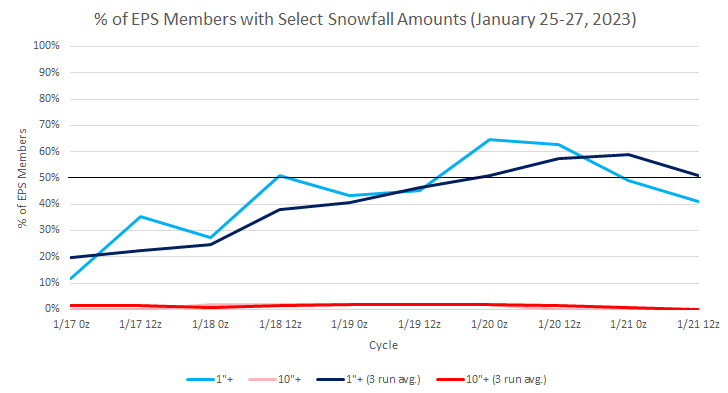
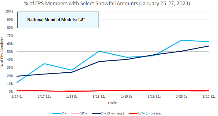
Latest EPS ensembles for the January 25-27 period. The 20z National Blend of Models shows just 0.3" of snow (1.8" on yesterday's run).
-
Occasional Thoughts on Climate Change
donsutherland1 replied to donsutherland1's topic in Climate Change
I am not sure what happened to Bastardi. It seems that he has become so consumed by climate change denial that he no longer has a grasp on actual facts--not forecasts, but facts--about the weather. For example, today he tweeted a reference to a post he made on a climate change denial site. He wrote, "Greta protesting coal plants in Germany blissfully unconcerned about the amount of cold left there this winter." Big problem. Germany has had an extraordinarily warm winter in what has been a "non-winter" in Europe.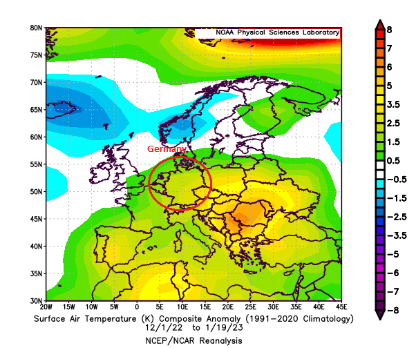
-
Occasional Thoughts on Climate Change
donsutherland1 replied to donsutherland1's topic in Climate Change
One day, there will be case studies on the energy industry. It will be an example of a very low innovation industry. The principal factor responsible is likely the subsidization of fossil fuels that takes place. No industry has ever received the scale of subsidization (direct and indirect) that is enjoyed by the fossil fuel industry. Annual subsidies exceed more than $5 trillion per year globally (IMF estimate of externalities borne by society). Had the fossil fuel producers been responsible to cover the full costs of their hazardous products, the prices would have been much higher. That, alone, would have provided powerful incentives for innovation away from the hazardous burning of fossil fuels, as the industry would face the existential need of either innovating or perishing as substitutes arose. -
February 1973 also had an epic snowstorm in the Southeast.
-
Snow season futility rankings through January 20th:
-
Morning thoughts… It will be mostly cloudy and mild. High temperatures will reach the lower 40s in most areas. Likely high temperatures around the region include: New York City (Central Park): 43° Newark: 45° Philadelphia: 44° Temperatures will average above normal through the weekend. Normals: New York City: 30-Year: 39.1°; 15-Year: 39.7° Newark: 30-Year: 39.6°; 15-Year: 40.4° Philadelphia: 30-Year: 40.9°; 15-Year: 41.5°
-
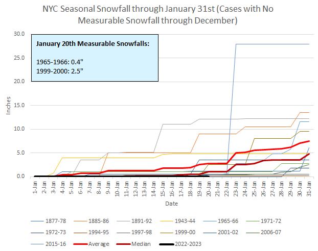
The 0z GGEM is ugly for New York City through 240 hours. Although the probability of no measurable snow for an entire snow season at Central Park is extremely low, history suggests a narrow pathway might exist. Both 2019-20 (1/18) and 2001-02 (1/19) had already seen their last measurable snowfall by this date. I don’t expect such a shutout, but merely note the bleak historical precedent for an absence of measurable snow from this date through the remainder of the snow season.
-
With no measurable snowfall in New York City on January 20th, only Winter 1973-1973 had a later first measurable snowfall (January 29th).
-
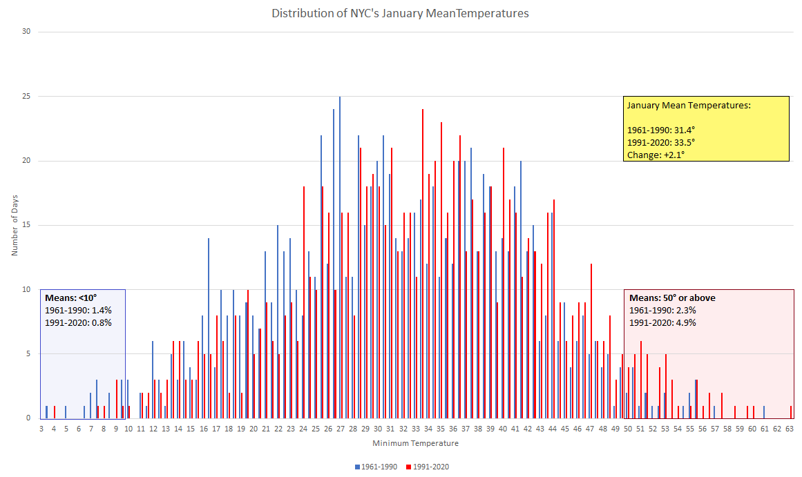
January has been warming, even as it isn't as noticeable as for some other months. The incidence of January days with a mean temperature of 50° or above has more than doubled.

-
The storm responsible for last night's rain and thunder has moved away from the region with partly sunny skies returning. In response temperatures rose well into the 40s, somewhat overperforming the guidance in what has been a remarkably warm January. A mild weekend lies ahead. Another storm will bring rain to the region later Sunday into Monday The lengthening measurable snow drought will persist in New York City and Philadelphia through at least early next week. Support for a measurable snowfall during the January 25-27 period has increased on the ensembles. The National Blend of Models currently shows 1.8" during January 25-26. Things can still change. A cooler pattern remains on course to develop during the closing days of January. The duration of this cooler period remains somewhat uncertain. For now, it appears that moderation could begin to occur during the latter part of the first week of February. The ENSO Region 1+2 anomaly was -0.3°C and the Region 3.4 anomaly was -0.2°C for the week centered around January 11. For the past six weeks, the ENSO Region 1+2 anomaly has averaged -0.37°C and the ENSO Region 3.4 anomaly has averaged -0.82°C. La Niña conditions could fade to neutral conditions during late winter or early spring. The SOI was +18.28 today. The preliminary Arctic Oscillation (AO) was -1.484 today. On January 18 the MJO was in Phase 1 at an amplitude of 0.554 (RMM). The January 17-adjusted amplitude was 0.553 (RMM). Based on sensitivity analysis applied to the latest guidance, there is an implied near 100% probability that New York City will have a warmer than normal January (1991-2020 normal). January will likely finish with a mean temperature near 41.1° (7.4° above normal).
-
Today is the 317th consecutive day without measurable snowfall in New York City (4th longest streak). However, there remains ensemble support for measurable snowfall during the January 25-27 period. The 1/20 20z National Blend of Models has now increased snowfall to 1.8" during that time.
-
No one can reliably make 6 week weather predictions here or elsewhere. Beyond 2 weeks, even the best ensemble systems have limited skill. These are important points that should be kept in mind at all times. Yet, especially on some social media sites, long-range maps—even operational ones—are posted, frequently with accompanying claims, as if the events are essentially certain to unfold. Often the highlighted maps are the most extreme ones and they are deployed in a demonstration of confirmation bias. When the events don’t occur as forecast, one sees timelines adjusted e.g., the cold would be coming in early January, then mid-January, then late January and so one. Then, when a cold shot ultimately arrives, even if fairly unimpressive, forecasting “victory” is proclaimed. Instead, there was no real skill involved. No pattern lasts beyond a finite but irregular period. Thus, if one keeps claiming the “wolf” is coming, it will eventually show up. When it does, does this mean that there was forecasting skill? Of course, the same constraints on predictive skill apply in many other areas (financial market forecasts are rife with similar bold claims and lack of skill). The reality is that time comes with uncertainty. Longer forecasts can never be perfect.