donsutherland1
-
Posts
24,192 -
Joined
Content Type
Profiles
Blogs
Forums
American Weather
Media Demo
Store
Gallery
Everything posted by donsutherland1
-
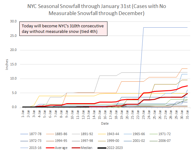
Parts of the region saw snow flurries and snow showers, along with temperatures in the 30s. Nevertheless, New York City (Central Park) again failed to record measurable snow. The measurable snow drought has now reached 311 consecutive days, which is the 4th longest such stretch on record. Tomorrow will be partly sunny and seasonably cold. An offshore storm could spread clouds into the region late tomorrow into Monday. Parts of eastern Long Island and eastern New England, including Boston, could see a period of snow. Right now, the odds favor a light to perhaps moderate snowfall in that area. Farther west, the measurable snow drought will very likely continue in Philadelphia and New York City. Milder weather will then return and persist through much of next week before cooler air returns. The duration of any cooler period is uncertain, as some of the extended guidance returns ridging to the East near the end of January or very early in February. The ENSO Region 1+2 anomaly was -0.3°C and the Region 3.4 anomaly was -0.7°C for the week centered around December 28. For the past six weeks, the ENSO Region 1+2 anomaly has averaged -0.48°C and the ENSO Region 3.4 anomaly has averaged -0.87°C. La Niña conditions will likely persist through mid-winter before fading to neutral conditions. The SOI was -9.42 today. The preliminary Arctic Oscillation (AO) was -1.233 today. On January 12 the MJO was in Phase 8 at an amplitude of 0.874 (RMM). The January 11-adjusted amplitude was 0.529 (RMM). Based on sensitivity analysis applied to the latest guidance, there is an implied 99% probability that New York City will have a warmer than normal January (1991-2020 normal). January will likely finish with a mean temperature near 40.6° (6.9° above normal).
-
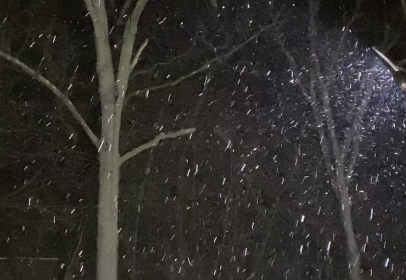
A short video from this morning.
-
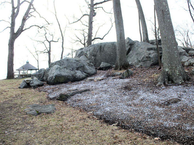
A dusting in colder spots.
-
Morning thoughts… It will be mostly cloudy with some flurries. High temperatures will reach the middle and upper 30s in most areas. Likely high temperatures around the region include: New York City (Central Park): 37° Newark: 37° Philadelphia: 39° Tomorrow will be fair and a bit warmer. Normals: New York City: 30-Year: 39.2°; 15-Year: 40.0° Newark: 30-Year: 39.7°; 15-Year: 40.7° Philadelphia: 30-Year: 41.0°; 15-Year: 41.8°
-
It will be brief. There was no accumulation.

-
If it holds together.
-
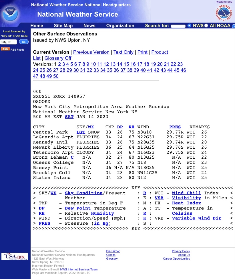
There’s a wet snow shower in parts of southern Westchester County. No accumulation has occurred.
-
Another day has passed and the misery inflicted by Winter 2022-2023 intensifies. New York City, Philadelphia, and Washington, DC have yet to see measurable snow.
-
A seasonably cool air mass is pushing into the region for the the weekend. An offshore storm could spread clouds into the region Sunday into Monday. Parts of eastern Long Island and eastern New England, including Boston, could see a period of snow. Right now, the odds favor a light to perhaps moderate snowfall in that area. Farther west, the measurable snow drought will very likely continue in Philadelphia and New York City. Milder weather will then return and persist through much of next week. The ENSO Region 1+2 anomaly was -0.3°C and the Region 3.4 anomaly was -0.7°C for the week centered around December 28. For the past six weeks, the ENSO Region 1+2 anomaly has averaged -0.48°C and the ENSO Region 3.4 anomaly has averaged -0.87°C. La Niña conditions will likely persist through mid-winter before fading to neutral conditions. The SOI was -14.93 today. The preliminary Arctic Oscillation (AO) was -1.028 today. On January 11 the MJO was in Phase 8 at an amplitude of 0.529 (RMM). The January 10-adjusted amplitude was 0.747 (RMM). Based on sensitivity analysis applied to the latest guidance, there is an implied 99% probability that New York City will have a warmer than normal January (1991-2020 normal). January will likely finish with a mean temperature near 40.6° (6.9° above normal).
-
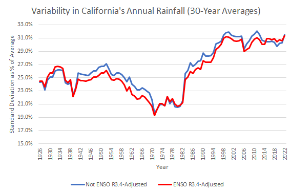
California's annual rainfall has grown more variable in recent decades.
-
5/11 (45%) cases. January-February Lowest AO in such winters: 1950-51: -2.718 1963-64: -3.371 1965-66: -2.225 1995-96: -3.607 2010-11: -3.806
-
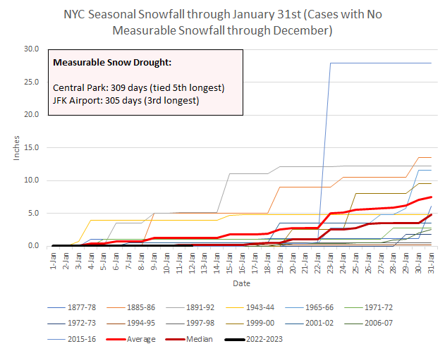
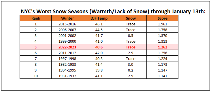
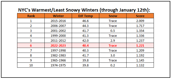
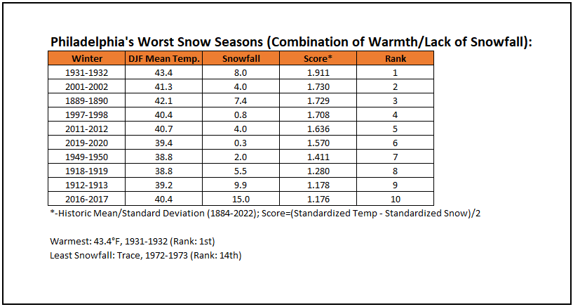
Currently, Winter 2022-2023 ranks among the 10 worst winters to date in NYC through January 12th (standardized temperatures and snowfall).
-
Unable to Renew Subscription
donsutherland1 replied to donsutherland1's topic in Forum Information & Help
Many thanks. That was last year. It’s all fine, now. -
-
Morning thoughts… Showers and drizzle will end this morning. The remainder of the day will be mostly cloudy. It will be unseasonably mild, but cooler air will begin to move into the region late in the day. High temperatures will reach the lower and middle 50s in most areas. Likely high temperatures around the region include: New York City (Central Park): 56° Newark: 57° Philadelphia: 55° A seasonably cool weekend lies ahead. Normals: New York City: 30-Year: 39.2°; 15-Year: 40.1° Newark: 30-Year: 39.7°; 15-Year: 40.8° Philadelphia: 30-Year: 41.1°; 15-Year: 41.9°
-
Hopefully, things will improve.
-
For reference: Philadelphia's worst snow seasons (combination of warmth and lack of snowfall).
-
Thunderstorms affected Philadelphia, Newark, and JFK Airport this evening. Additional rain is likely tonight into tomorrow. A general 0.50"-1.00" rainfall is likely. Temperatures will be well above seasonal norms. Following the storm, a seasonably cool air mass will overspread the region for the close of the week. An offshore storm could spread clouds into the region Sunday into Monday. Parts of eastern Long Island and eastern New England, including Boston, could see a period of snow. Farther west, the measurable snow drought will likely continue in Philadelphia and New York City. Milder weather will then return and persist through much of next week. The ENSO Region 1+2 anomaly was -0.3°C and the Region 3.4 anomaly was -0.7°C for the week centered around December 28. For the past six weeks, the ENSO Region 1+2 anomaly has averaged -0.48°C and the ENSO Region 3.4 anomaly has averaged -0.87°C. La Niña conditions will likely persist through mid-winter before fading to neutral conditions. The SOI was -0.80 today. The preliminary Arctic Oscillation (AO) was -0.609 today. On January 10 the MJO was in Phase 7 at an amplitude of 0.745 (RMM). The January 9-adjusted amplitude was 0.914 (RMM). Based on sensitivity analysis applied to the latest guidance, there is an implied 99% probability that New York City will have a warmer than normal January (1991-2020 normal). January will likely finish with a mean temperature near 40.6° (6.9° above normal).
-
E PA/NJ/DE Winter 2022-2023 OBS Thread
donsutherland1 replied to Ralph Wiggum's topic in Philadelphia Region
The story of Winter 2022-23 in the eastern U.S. so far. More thunder than snow in Philadelphia.
-
Report: Another Year of Record Heat for the Oceans
donsutherland1 replied to donsutherland1's topic in Climate Change
I believe we will get a good example of where things stand this year and next year as the La Niña ends. I suspect that the outcome will validate some acceleration in the rate of warming with this year winding up among the 3 warmest years and next year probably setting a record. The warmth after 3 years of La Niña is stunning. Even a weak El Niño could produce record warmth as anthropogenic greenhouse gas forcing continues to grow. -
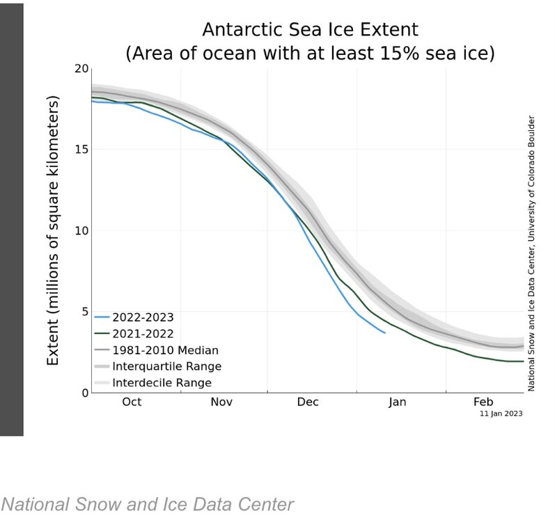
Antarctic sea ice extent is running at record low figures right now.
-
A lot can change on the guidance in that timeframe. It does look to get back to at least a period of seasonably cold weather as the month nears an end.
-
It will be tough. We'd have to go through all of January and then through the first five days of February to set the mark. It's not impossible, but a lot can change over a 3-week timeframe.
-
Yes. The record for JFK and Central Park is 332 consecutive days.
-
Today will become the 309th consecutive day during which Central Park has received no measurable snowfall. That will tie March 15, 1997 - January 17, 1998 for the 5th longest stretch without measurable snowfall.