

donsutherland1
-
Posts
24,176 -
Joined
Content Type
Profiles
Blogs
Forums
American Weather
Media Demo
Store
Gallery
Everything posted by donsutherland1
-
At 11 pm, Atlantic City (69°), New Haven (57°), and White Plains (63°) have all set new record highs. More are likely.
-
Morning thoughts… Today will be variably cloudy and unseasonably warm. High temperatures will reach the lower 60s along the coastline and middle and upper 60s in most other areas. A shower is possible in some areas. Likely high temperatures around the region include: New York City (Central Park): 64° Newark: 66° Philadelphia: 68° It will turn somewhat cooler starting tomorrow. Normals: New York City: 30-Year: 40.1°; 15-Year: 41.1° Newark: 30-Year: 40.6°; 15-Year: 41.8° Philadelphia: 30-Year: 41.9°; 15-Year: 42.9°
-
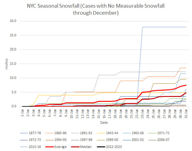
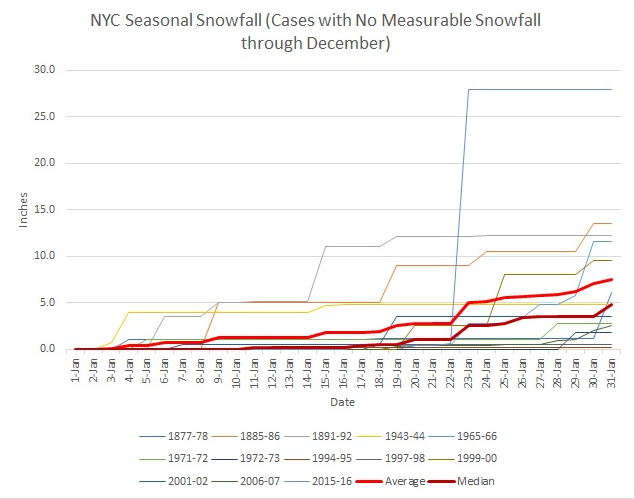
Graph showing winters without measurable snowfall through December 31s through January 3:
-
Exceptionally warm air began pushing into the region today. Parts of the Middle Atlantic region saw record warmth today. Records included: Baltimore: 69° (old record: 68°, 2000) Sterling, VA: 69° (old record: 68°, 2000) Washington, DC: 69° (old record: 68°, 2000 and 2004) Wilmington, DE: 64° (tied record set in 2000) Wilmington, NC: 77° (tied record set in 2000 and tied in 2020) Tomorrow will be mainly cloudy and very warm. The temperature will likely soar into the 60s as far north as southern New England. Some parts of the Middle Atlantic region could see the thermometer reach or exceed 70°. Overall, readings will average 10°-15° above normal during the first week of the month. The second week of January could see some cooling from the first week's exceptional warmth, but a cold outcome is unlikely. 2022 became the 14th year during which New York City received no measurable snowfall through December 31st. During the 13 prior years, mean seasonal snowfall was 16.0" (median seasonal snowfall: 16.3"). Just 8% of those winters rallied to see 30" or more seasonal snowfall. 31% of those winters wound up with less than 10" of seasonal snowfall. Just under half (46%) had 20" or more seasonal snowfall. The lowest seasonal snowfall for those cases of 2.8" was recorded in 1972-1973. The highest seasonal snowfall for those cases was 32.8", which occurred during 2015-2016. The ENSO Region 1+2 anomaly was -0.3°C and the Region 3.4 anomaly was -0.7°C for the week centered around December 28. For the past six weeks, the ENSO Region 1+2 anomaly has averaged -0.48°C and the ENSO Region 3.4 anomaly has averaged -0.87°C. La Niña conditions will likely persist through mid-winter before fading to neutral conditions. The SOI was +19.23 today. The preliminary Arctic Oscillation (AO) was -0.318 today.
-
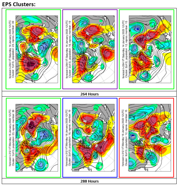
With respect to fantasy range (> 240 hours out) storminess suggested by some ensemble members, below are the 500 mb clusters. The first set (23 members) would favor a storm that moves off the coast too far to the south and east to pose much of a winter weather threat for the northern Middle Atlantic Region (confirmed by the 1000 mb cluster). The second set (16 members) might hold the most promise. In short, it is premature to have a great deal of confidence in what looks like a potential snowstorm on some of the ensemble members through the mists of fantasy range. For a fresh reminder of the importance of waiting for more data--particularly in the higher skill range of the guidance--the operational ECMWF had a significant to major snowstorm at the end of its 1/3 0z run. 12 hours later, the 1/3 12z cycle had no such event.
-
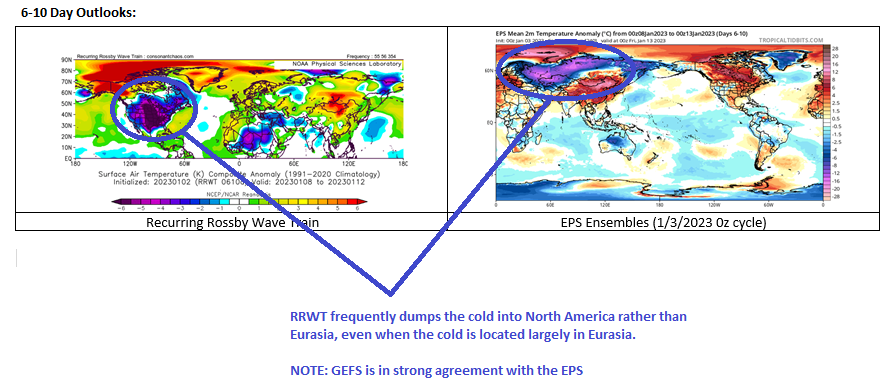
Almost certainly, the RRWT map will be wrong. It frequently dumps the Northern Hemisphere's cold into North America. Its current 6-10 day outlook provides a good illustration of that tendency. The 6-10 day period will likely be cooler than the first week of January, but there remains little support for a cold outcome. The EPS and GEFS are in very strong agreement that temperatures will descend closer to normal but the overall 6-10 day period will be warmer than normal. I suspect that the problem with the RRWT tool is that it treats all Rossby Waves alike. Instead, origin and duration matter. From a recent paper: Higher than normal medium-range skill scores are often associated with the presence of long-lasting RWPs (about 8 days) in the initial conditions, very often triggered far away in the west Pacific (RWP_pac_eu). Bad medium-range skill scores are instead associated with shorter RWPs coming from central US or the west Atlantic. The analysis of probabilistic skill scores also supports an increase in predictive skill associated with long RWPs coming from the west Pacific, even at longer ranges, with better skill up to week 3, suggesting a possible link with MJO events.
-
Morning thoughts… Today will be mostly cloudy and mild. Showers are possible. High temperatures will reach the middle and upper 50s in most areas. Some areas could reach the lower 60s. Likely high temperatures around the region include: New York City (Central Park): 57° Newark: 60° Philadelphia: 62° It will turn somewhat cooler starting Thursday. Normals: New York City: 30-Year: 40.3°; 15-Year: 41.2° Newark: 30-Year: 40.7°; 15-Year: 41.9° Philadelphia: 30-Year: 42.1°; 15-Year: 43.1°
-
Congratulations Rodney S. Well done.
-
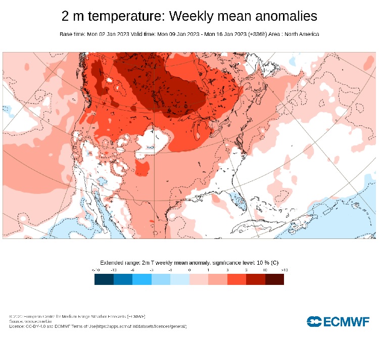
Through week 2, above normal temperatures are forecast to continue in the U.S. on the EPS weekly guidance. Beyond 2 weeks, skill scores are low.
-
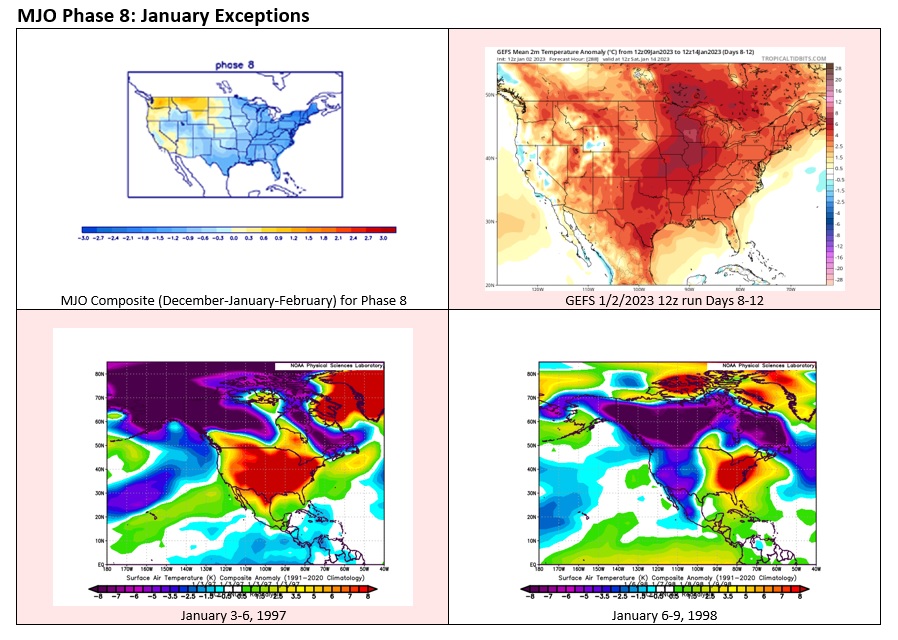
Tomorrow will be variably cloudy and unseasonably mild. The warmth will peak on Wednesday with temperatures rising into the 60s as far north as southern New England. Overall, readings will average 10°-15° above normal during the first week of the month. The second week of January could see some cooling from the first week's exceptional warmth, but a cold outcome is not assured. Although some of the guidance suggests that the MJO could move into Phase 8 at an amplitude at or above 1.000 within two weeks, Phase 8 is not always cold. During January 3-6, 1997, much of the CONUS was much warmer than normal despite the MJO's being in Phase 8 coupled with a negative Arctic Oscillation. While 1997-style warmth is not yet the most likely outcome, a scenario where temperatures generally reach the 40s across the region during the daytime hours through mid-month seems more likely than one with much below normal readings. 2022 became the 14th year during which New York City received no measurable snowfall through December 31st. During the 13 prior years, mean seasonal snowfall was 16.0" (median seasonal snowfall: 16.3"). Just 8% of those winters rallied to see 30" or more seasonal snowfall. 31% of those winters wound up with less than 10" of seasonal snowfall. Just under half (46%) had 20" or more seasonal snowfall. The lowest seasonal snowfall for those cases of 2.8" was recorded in 1972-1973. The highest seasonal snowfall for those cases was 32.8", which occurred during 2015-2016. The ENSO Region 1+2 anomaly was -0.3°C and the Region 3.4 anomaly was -0.7°C for the week centered around December 28. For the past six weeks, the ENSO Region 1+2 anomaly has averaged -0.48°C and the ENSO Region 3.4 anomaly has averaged -0.87°C. La Niña conditions will likely persist through mid-winter before fading to neutral conditions. The SOI was +30.81 today. The preliminary Arctic Oscillation (AO) was -0.117 today. On December 31 the MJO was not available. The December 30-adjusted amplitude was 1.635 (RMM).
-
There is some discussion that the latest GEFS forecast of widespread 5-day average warm anomalies would be wrong should the MJO forecast be accurate. However, the January 3-6, 1997 exception argues for waiting for more data before reaching conclusions.
-
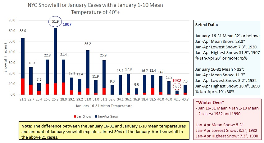
IMO, it is premature to print the obituary for Winter 2022-2023 in the New York City area, even as some might be drafting, even revising, their obituaries. However, a strong signal about the overall character of Winter 2022-2023 could become evident by the end of January. If the January 16-31 mean temperature exceeds 32° in New York City following a 40° or above January 1-10 mean temperature, that could provide strong evidence that Winter 2022-2023 will see much below normal snowfall. Caveats apply from the sample size (n=21) and the impact of climate change on precipitation outcomes and hemispheric patterns. For those keen on writing Winter 2022-2023's obituary but facing "writers' block," some boilerplate language follows: This winter had great promise for snowfall. With deep Atlantic blocking throughout December, the rise of the PNA to positive levels, and a 3-sigma Arctic blast, the pattern became especially favorable for snowfall. Numerous significant snowstorms heralding snowy winters had occurred in the midst of similar patterns and sufficient cold air. Yet, despite the anticipation and excitement, December saw no measurable snowfall. For snow lovers, it was as joyless a Hanukkah and Christmas as one could have imagined. The biting Arctic winds added to the sting of the sight of barren frozen ground. Overall, Winter 2022-2023 proved to be remarkably mild and its lack of snowfall was noteworthy. Winter 2022-2023 is will be remembered only in the nightmares of snowless winters. Back to January 2, a great deal of patience is required while much of the New York City-Newark-Philadelphia areas await their first measurable snowfall of the winter.
-
Morning thoughts… Today will be partly sunny and mild. High temperatures will reach the lower and middle 50s in most areas. Likely high temperatures around the region include: New York City (Central Park): 54° Newark: 57° Philadelphia: 59° Temperatures will be above to much above average into at least the middle of next week. Normals: New York City: 30-Year: 40.4°; 15-Year: 41.4° Newark: 30-Year: 40.9°; 15-Year: 42.1° Philadelphia: 30-Year: 42.2°; 15-Year: 43.3°
-
2023 began on a balmy note. Temperatures rose into the 50s across the region under abundant sunshine. Tomorrow will be a similar day with continued mild temperatures. Across the Atlantic Ocean, it was as if New Year's Day marked the start of summer. Numerous monthly records, including national records, were demolished by the warmth. At Warsaw, the temperature rose to 66°. Delemont, Switzerland reached 68° while Kaposvar, Hungary hit 65°. Select 75° or above highs in France included: Aicirits: 76° Asson: 76° Cambo les Bains: 76° Capbreton: 76° Dax: 75° Lanne en Baretous: 76° Lasseube: 76° Navarrenx: 76° Oloron: 76° Saint Gladie: 76° Samadet: 76° Soorts Hossegor: 76° Trois Villes: 77° The first week of January will see a continuation of the mild regime that is currently in place. Readings will average 5°-10° above normal. The warmth will likely peak during the middle of the week when the mercury approaches or reaches 60° or above as far north as southern New England. The height of the warmth will likely coincide with an AO-/PNA+ pattern. During January 1950-2022, AO-/PNA+ patterns saw 1% of days reach 60° or above in New York City vs. 5.7% of days for all other patterns. The highest January temperature during an AO-/PNA+ pattern occurred on January 8, 1998 when the thermometer reached 65°. The second week of January could see some cooling from the first week's exceptional warmth, but a cold outcome is not assured. Overall, a warmer than normal January appears to be likely. 2022 became the 14th year during which New York City received no measurable snowfall through December 31st. During the 13 prior years, mean seasonal snowfall was 16.0" (median seasonal snowfall: 16.3"). Just 8% of those winters rallied to see 30" or more seasonal snowfall. 31% of those winters wound up with less than 10" of seasonal snowfall. Just under half (46%) had 20" or more seasonal snowfall. The lowest seasonal snowfall for those cases of 2.8" was recorded in 1972-1973. The highest seasonal snowfall for those cases was 32.8", which occurred during 2015-2016. The measurable snow drought could end as early as Friday, but that's not assured. There is a small cluster of EPS members (14%) that show 1" or more snow at New York City for January 6th into January 7th. A measurable snowfall is 0.1". However, that percentage has fallen from 22% yesterday. The ENSO Region 1+2 anomaly was -0.1°C and the Region 3.4 anomaly was -0.8°C for the week centered around December 21. For the past six weeks, the ENSO Region 1+2 anomaly has averaged -0.73°C and the ENSO Region 3.4 anomaly has averaged -0.88°C. La Niña conditions will likely persist through mid-winter. The SOI was +28.41 today. The preliminary Arctic Oscillation (AO) was -0.033 today. On December 30 the MJO was in Phase 6 at an amplitude of 1.635 (RMM). The December 29-adjusted amplitude was 1.633 (RMM).
-
January cases following past years with no measurable snowfall at Central Park through December 31st. A median line is included, because winter 2015-16 skews the mean.
-
January 17, 1977 had a high temperature of 8° at JFK. The temperature stayed in the single digits during the afternoon of December 25, 1980. During the 1985 Arctic outbreak, the coldest maximum temperature was 10°.
-
Morning thoughts… Today will be partly to mostly sunny and mild. High temperatures will reach the lower 50s in most areas. Likely high temperatures around the region include: New York City (Central Park): 53° Newark: 55° Philadelphia: 56° Temperatures will be above to much above average into at least the middle of next week. Normals: New York City: 30-Year: 40.6°; 15-Year: 41.5° Newark: 30-Year: 41.1°; 15-Year: 42.2° Philadelphia: 30-Year: 42.4°; 15-Year: 43.4°
-
December is concluding on a warmer than normal note in New York City. New York City is finishing December with a mean temperature of 38.5°, which was 0.6° below normal. It would have been 0.6° above normal against the earlier baseline and ranks among the 48 warmest Decembers on record. Newark wound up slightly warmer than normal for the month as a whole. The first week of January will see a continuation of the mild regime. The week will likely see readings average 5°-10° above normal. The warmth will likely peak during the middle of the week when the mercury approaches or reaches 60° or above as far north as southern New England. The height of the warmth will likely coincide with an AO-/PNA+ pattern. During January 1950-2022, AO-/PNA+ patterns saw 1% of days reach 60° or above in New York City vs. 5.7% of days for all other patterns. The highest January temperature during an AO-/PNA+ pattern occurred on January 8, 1998 when the thermometer reached 65°. The second week of January could see some cooling from the first week's exceptional warmth, but a cold outcome is not assured. Overall, a warmer than normal January appears to be likely. 2022 is becoming the 14th year during which New York City receives no measurable snowfall through December 31st. During the 13 prior years, mean seasonal snowfall was 16.0" (median seasonal snowfall: 16.3"). Just 8% of those winters rallied to see 30" or more seasonal snowfall. 31% of those winters wound up with less than 10" of seasonal snowfall. Just under half (46%) had 20" or more seasonal snowfall. The lowest seasonal snowfall for those cases of 2.8" was recorded in 1972-1973. The highest seasonal snowfall for those cases was 32.8", which occurred during 2015-2016. The measurable snow drought could end as early as next Friday. There is a cluster of EPS members (22%) that show 1" or more snow at New York City for January 6th into January 7th. A measurable snowfall is 0.1". The ENSO Region 1+2 anomaly was -0.1°C and the Region 3.4 anomaly was -0.8°C for the week centered around December 21. For the past six weeks, the ENSO Region 1+2 anomaly has averaged -0.73°C and the ENSO Region 3.4 anomaly has averaged -0.88°C. La Niña conditions will likely persist through mid-winter. The SOI was +29.48 today. The preliminary Arctic Oscillation (AO) was -0.415 today. On December 29 the MJO was in Phase 6 at an amplitude of 1.629 (RMM). The December 28-adjusted amplitude was 1.654 (RMM).
-
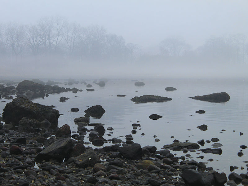
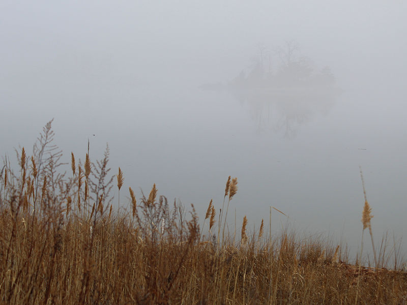
This morning, thick fog developed along the Long Island Sound.

-
January 2023 temperature forecast contest
donsutherland1 replied to Roger Smith's topic in Weather Forecasting and Discussion
DCA _ NYC _ BOS _ ORD _ ATL _ IAH _ DEN _ PHX _ SEA 4.5 4.6 4.5 5.2 4.0 3.2 1.8 0.2 2.0 -
Morning thoughts… Today will be mostly cloudy and mild. Some showers are possible. High temperatures will reach the lower 50s in most areas. Likely high temperatures around the region include: New York City (Central Park): 53° Newark: 54° Philadelphia: 54° Temperatures will be above to much above average into at least the middle of next week. Normals: New York City: 30-Year: 40.7°; 15-Year: 41.7° Newark: 30-Year: 41.2°; 15-Year: 42.4° Philadelphia: 30-Year: 42.5°; 15-Year: 43.6° Across the Atlantic, a large part of Europe is experiencing record warmth to end 2022. A number of locations are at or near monthly record highs.
-
Get well soon.
-
Yes. That is correct.
-
Under bright sunshine, temperatures surged into the upper 50s and lower 60s across much of the region. Coastal sections remained cooler due to a light onshore breeze. In Canada, Montreal, Ottawa, and Toronto all saw record high temperatures. Very mild air now covers the region. Highs will generally reach the 50s in most places in coming days. The first week of January will see a continuation of the mild regime. The week will likely see readings average 5°-10° above normal. The warmth will likely peak during the middle of the week when the mercury approaches or reaches 60° or above as far north as southern New England. The height of the warmth will likely coincide with an AO-/PNA+ pattern. During January 1950-2022, AO-/PNA+ patterns saw 1% of days reach 60° or above in New York City vs. 5.7% of days for all other patterns. The highest January temperature during an AO-/PNA+ pattern occurred on January 8, 1998 when the thermometer reached 65°. The second week of January could see some cooling from the first week's exceptional warmth, but a cold outcome is not assured. Overall, a warmer than normal January appears to be likely. It is virtually certain that 2022 will become the 14th year during which New York City receives no measurable snowfall through December 31st. During the 13 prior years, mean seasonal snowfall was 16.0" (median seasonal snowfall: 16.3"). Just 8% of those winters rallied to see 30" or more seasonal snowfall. 31% of those winters wound up with less than 10" of seasonal snowfall. Just under half (46%) had 20" or more seasonal snowfall. The lowest seasonal snowfall for those cases of 2.8" was recorded in 1972-1973. The highest seasonal snowfall for those cases was 32.8", which occurred during 2015-2016. The ENSO Region 1+2 anomaly was -0.1°C and the Region 3.4 anomaly was -0.8°C for the week centered around December 21. For the past six weeks, the ENSO Region 1+2 anomaly has averaged -0.73°C and the ENSO Region 3.4 anomaly has averaged -0.88°C. La Niña conditions will likely persist through mid-winter. The SOI was +26.57 today. The preliminary Arctic Oscillation (AO) was -0.422 today. On December 28 the MJO was in Phase 5 at an amplitude of 1.651 (RMM). The December 27-adjusted amplitude was 1.713 (RMM). Based on sensitivity analysis applied to the latest guidance, there is an implied near 100% probability that New York City will have a colder than normal December (1991-2020 normal). December will likely finish with a mean temperature near 38.4° (0.7° below normal).
-
61 in Central Park and both LaGuardia and Newark.


