

donsutherland1
-
Posts
24,192 -
Joined
Content Type
Profiles
Blogs
Forums
American Weather
Media Demo
Store
Gallery
Everything posted by donsutherland1
-
Occasional Thoughts on Climate Change
donsutherland1 replied to donsutherland1's topic in Climate Change
A great summary video on Arctic developments by Dr. Jason Box: -
Five points: 1. The map is using the warmest 1991-2020 baseline. 2. Use of the current baseline "resets" the maps to a warmer baseline and masks the warming that has occurred in recent decades. Thus, when discussing climate or making climate-related judgments, they don't tell the full story. When NCEI releases the data early next year, 2022 will very likely rank among the 20 warmest years in the CONUS since 1895 and perhaps among the top 10. 3. The extremes matter. They can't be "undone" simply by pointing to averages. There were a number of historic hot events and some cold ones (e.g., the most recent Arctic blast that saw Casper reach an all-time record low -42F). 4. His conclusion in the second sentence has no support in the scientific literature and no connection to the climate record. 5. I'm not sure what ranges the map is using, but here's the NOAA map for January 1-December 26:

-
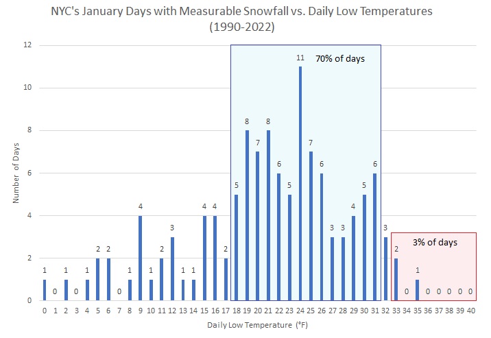
I agree. While there are no guarantees, it should be noted that approximately two-thirds of New York City's seasonal snowfall typically occurs after January 16.
-
The January record is 18 days (January 13 through January 30, 1932).
-
Through at least the first week of January, the low temperature in New York City will likely remain above freezing. That implies a high probability that New York City will not see its first measurable snowfall until after the first week of January.
-
Morning thoughts… Today will be mostly sunny and mild. High temperatures will reach the lower and middle 40s in most areas. Likely high temperatures around the region include: New York City (Central Park): 43° Newark: 45° Philadelphia: 45° Temperatures will be above to much above average through at least the coming weekend. Normals: New York City: 30-Year: 41.3°; 15-Year: 42.2° Newark: 30-Year: 41.8°; 15-Year: 42.9° Philadelphia: 30-Year: 43.1°; 15-Year: 44.1°
-
I suspect that temperatures will cool, but it remains uncertain whether there will be any significant Arctic air through perhaps mid-January. Much can still change.
-
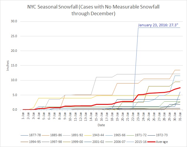
The mercury pushed into the middle 30s today as warmer air began overspreading the region. Tomorrow, the thermometer will very likely break 40°. By the end of the week, temperatures could reach or exceed 50° in much of the area. The first week of January will likely see much above normal temperatures across the region. The week will likely see readings average 5°-10° above normal. Although some of the guidance suggests that stratospheric warming could commence during the second week of January, skill scores at that range, even before considering whether the warming would be sufficient to displace or split the polar vortex, are low. Thus, while the second week of January could see some cooling from the first week's exceptional warmth, a cold outcome is not assured. Indeed, the latest EPS weeklies illustrate the idea that a cold outcome isn't assured. It appears increasingly very likely that 2022 will become the 14th year during which New York City receives no measurable snowfall through December 31. During the 13 prior years, mean seasonal snowfall was 16.0" (median seasonal snowfall: 16.3"). Just 8% of those winters rallied to see 30" or more seasonal snowfall. 31% of those winters wound up with less than 10" of seasonal snowfall. Just under half (46%) had 20" or more seasonal snowfall. The lowest seasonal snowfall for those cases of 2.8" was recorded in 1972-1973. The highest seasonal snowfall for those cases was 32.8", which occurred during 2015-2016. The ENSO Region 1+2 anomaly was -0.1°C and the Region 3.4 anomaly was -0.8°C for the week centered around December 21. For the past six weeks, the ENSO Region 1+2 anomaly has averaged -0.73°C and the ENSO Region 3.4 anomaly has averaged -0.88°C. La Niña conditions will likely persist through mid-winter. The SOI was +19.56 today. The preliminary Arctic Oscillation (AO) was -0.937 today. On December 25 the MJO was in Phase 5 at an amplitude of 1.957 (RMM). The December 24-adjusted amplitude was 1.868 (RMM). Based on sensitivity analysis applied to the latest guidance, there is an implied 98% probability that New York City will have a colder than normal December (1991-2020 normal). December will likely finish with a mean temperature near 37.7° (1.4° below normal).
-
On December 24, 2022, the maximum temperature in New York City was 15°F (-9.4°C). That was the coldest December high temperature since December 25, 1983 when the temperature topped out at 13°F (-10.6°C) and tied for the 17th coldest December high on record.
-
The high was 9° in 1985. So 1980 and 1985 had the only diurnal highs below 10° during your lifetime.
-
Morning thoughts… Sunshine will return and it will turn noticeably milder. High temperatures will reach the middle 30s in most areas. Likely high temperatures around the region include: New York City (Central Park): 35° Newark: 37° Philadelphia: 37° Temperatures will be above to much above average through the coming weekend. Normals: New York City: 30-Year: 41.5°; 15-Year: 42.4° Newark: 30-Year: 42.0°; 15-Year: 43.1° Philadelphia: 30-Year: 43.3°; 15-Year: 44.3°
-
The diurnal high on 12/25/1980 was 7. The temperature reached 10 at 4 pm on January 17, 1977 (topping out at 12).
-
NYC bottomed out at -1 on December 25, 1980.
-
It may not be dry. There are signals on the EPS that the January 1-2 and January 5-7 periods could be wet.
-
Tomorrow will mark the start of a noticeable warmup. By the end of the week, temperatures could reach or exceed 50° in much of the area. The first week of January will likely see much above normal temperatures across the region. The week will likely see readings average 5°-10° above normal. Although some of the guidance suggests that stratospheric warming could commence during the second week of January, skill scores at that range, even before considering whether the warming would be sufficient to displace or split the polar vortex, are low. Thus, while the second week of January could see some cooling from the first week's exceptional warmth, a cold outcome is not assured. Indeed, the latest EPS weeklies illustrate the idea that a cold outcome isn't assured. It appears increasingly likely that 2022 will become the 14th year during which New York City receives no measurable snowfall through December 31. During the 13 prior years, mean seasonal snowfall was 16.0". Just 8% of those winters rallied to see 30" or more seasonal snowfall. 31% of those winters wound up with less than 10" of seasonal snowfall. Just under half (46%) had 20" or more seasonal snowfall. The lowest seasonal snowfall for those cases of 2.8" was recorded in 1972-1973. The highest seasonal snowfall for those cases was 32.8", which occurred during 2015-2016. The ENSO Region 1+2 anomaly was -0.1°C and the Region 3.4 anomaly was -0.8°C for the week centered around December 21. For the past six weeks, the ENSO Region 1+2 anomaly has averaged -0.73°C and the ENSO Region 3.4 anomaly has averaged -0.88°C. La Niña conditions will likely persist through mid-winter. The SOI was +17.59 today. The preliminary Arctic Oscillation (AO) was -2.421 today. On December 24 the MJO was in Phase 5 at an amplitude of 1.869 (RMM). The December 23-adjusted amplitude was 1.918 (RMM). Based on sensitivity analysis applied to the latest guidance, there is an implied 95% probability that New York City will have a colder than normal December (1991-2020 normal). December will likely finish with a mean temperature near 37.7° (1.4° below normal).
-
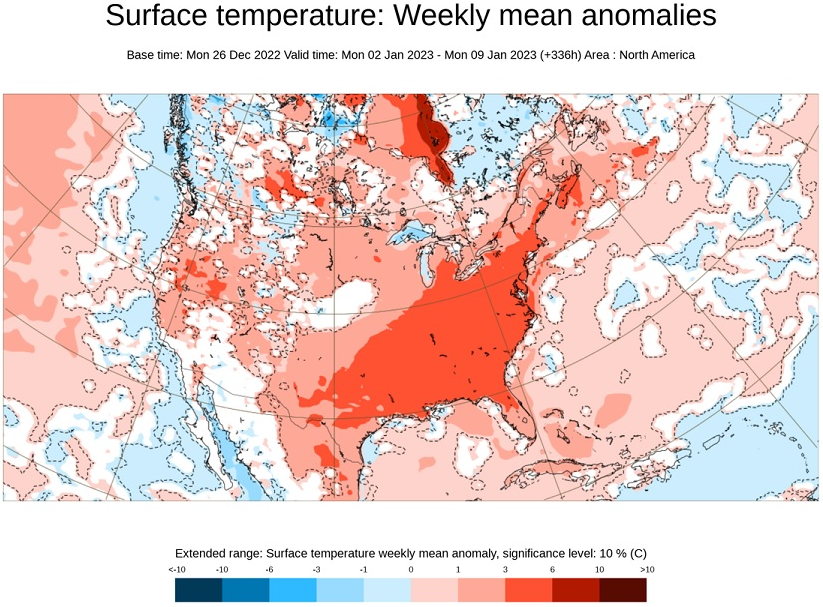
The latest EPS weekly guidance for January 2-9, 2023:
-
I agree. Things are changing.
-
Only winters 1885-86 and 2015-16 had subzero lows.
-
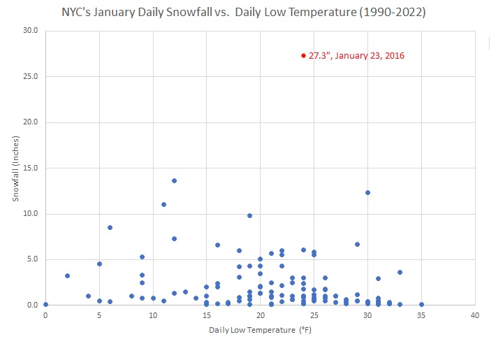
New York City's January snowfall in past winters when no measurable snowfall was recorded through December 31st.
-
8% of such winters, not 8 cases. So, yes, it was just 1 case. While the sample size is small, there's probably enough data to suggest that the outcome favors a winter with below normal snow (not a guarantee, but that's where things are leaning).
-
Morning thoughts… Clouds will increase. It will be another cold day. High temperatures will reach the upper 20s and lower 30s in most areas. Likely high temperatures around the region include: New York City (Central Park): 29° Newark: 31° Philadelphia: 31° It will turn noticeably milder tomorrow. Normals: New York City: 30-Year: 41.7°; 15-Year: 42.6° Newark: 30-Year: 42.2°; 15-Year: 43.3° Philadelphia: 30-Year: 43.5°; 15-Year: 44.5°
-
A steady moderation of temperatures will commence tomorrow. By the end of the week, temperatures could reach or exceed 50° in much of the area. The first week of January will likely see much above normal temperatures across the region. It appears increasingly likely that 2022 will become the 14th year during which New York City receives no measurable snowfall through December 31. During the 13 prior years, mean seasonal snowfall was 16.0". Just 8% of those winters rallied to see 30" or more seasonal snowfall. 31% of those winters wound up with less than 10" of seasonal snowfall. Just under half (46%) had 20" or more seasonal snowfall. The lowest seasonal snowfall for those cases of 2.8" was recorded in 1972-1973. The highest seasonal snowfall for those cases was 32.8", which occurred during 2015-2016. The ENSO Region 1+2 anomaly was -0.1°C and the Region 3.4 anomaly was -0.9°C for the week centered around December 14. For the past six weeks, the ENSO Region 1+2 anomaly has averaged -0.95°C and the ENSO Region 3.4 anomaly has averaged -0.92°C. La Niña conditions will likely persist through mid-winter. The SOI was +17.59 today. The preliminary Arctic Oscillation (AO) was -3.297 today. On December 23 the MJO was in Phase 5 at an amplitude of 1.917 (RMM). The December 22-adjusted amplitude was 1.799 (RMM). Based on sensitivity analysis applied to the latest guidance, there is an implied 93% probability that New York City will have a colder than normal December (1991-2020 normal). December will likely finish with a mean temperature near 37.6° (1.5° below normal).
-
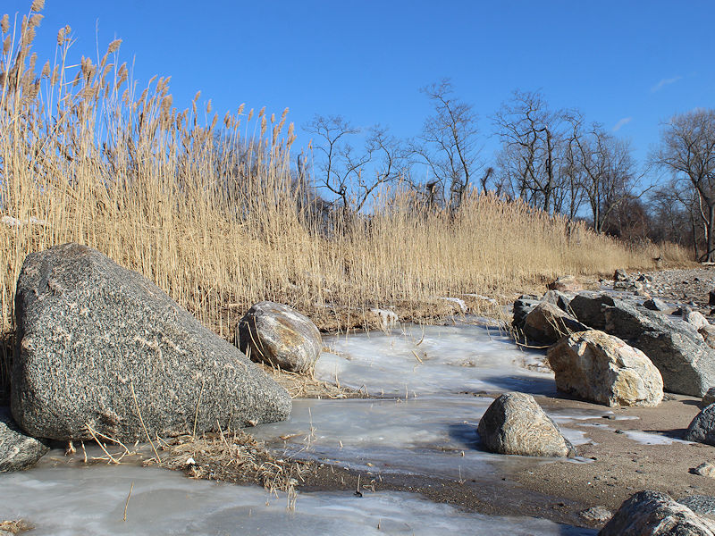
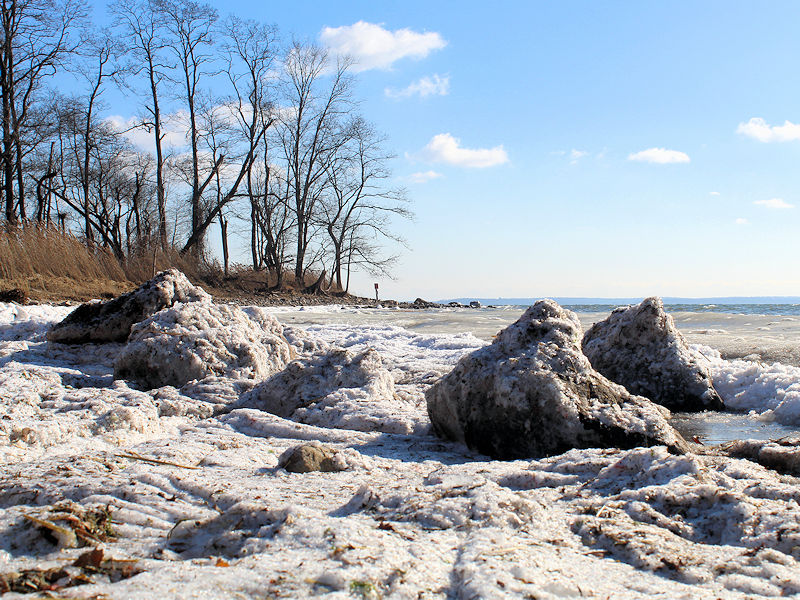
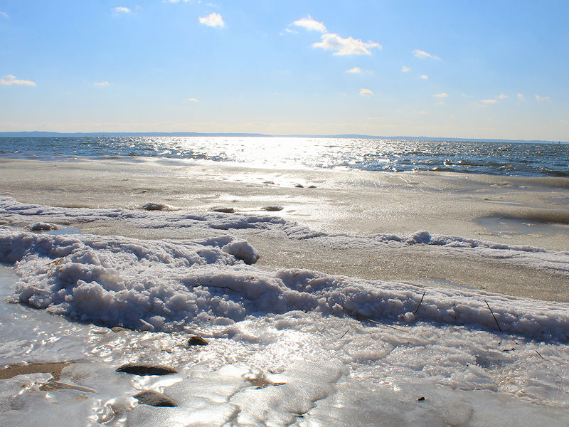
Ice along the shore of the Long Island Sound.
-
Historic Christmas Lake Effect Blizzard
donsutherland1 replied to BuffaloWeather's topic in Upstate New York/Pennsylvania
Excerpt from the latest PNS: ...Erie County... Buffalo Airport 43.0 in 0655 AM 12/25 Official NWS Obs Williamsville 3.8 E 31.5 in 0705 AM 12/25 COCORAHS Amherst 5.4 NNE 25.5 in 0800 AM 12/25 COCORAHS Hamburg 0.4 WSW 11.8 in 0700 AM 12/25 COCORAHS Boston 2.5 NE 8.8 in 0700 AM 12/25 COCORAHS Glenwood 1.0 SE 4.3 in 0700 AM 12/25 COCORAHS


