

donsutherland1
-
Posts
24,192 -
Joined
Content Type
Profiles
Blogs
Forums
American Weather
Media Demo
Store
Gallery
Everything posted by donsutherland1
-
December 22nd - 23rd Cutter Discussion and Observations
donsutherland1 replied to NJwx85's topic in New York City Metro
It is now snowing in Larchmont -
Historic Christmas Lake Effect Blizzard
donsutherland1 replied to BuffaloWeather's topic in Upstate New York/Pennsylvania
Buffalo Observation: 0 visibility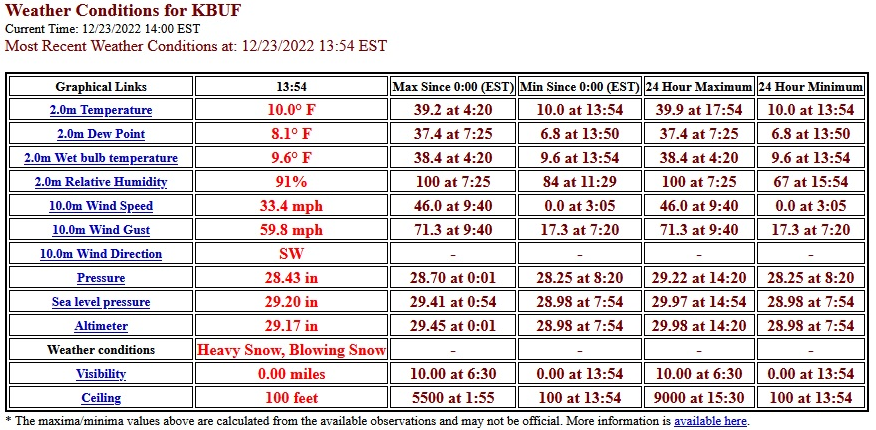
-
December 22nd - 23rd Cutter Discussion and Observations
donsutherland1 replied to NJwx85's topic in New York City Metro
Front is coming through with high winds and some rain in Larchmont, NY. -
Near the start of January or just afterward, if the ensembles are correct.
-
It could be a week later. Afterward, it's difficult to associate it with the blocking. P.S. Buffalo has seen the passage of the Arctic cold front. There is currently heavy lake effect snow with 1/8 mile visibility.
-
It is remarkable. This would be a rare event.
-
None. The record low for the 11 prior Decembers with a -4 AO is 0.5" in December 1978.
-
Morning thoughts… It will be rainy, windy, and mild this morning. Temperatures will fall throughout the day and reach the lower 20s and even teens by this evening. Significant coastal flooding is likely at this morning’s high tide. Temperatures will fall sharply late in the day. Likely high temperatures around the region include: New York City (Central Park): 52° Newark: 55° Philadelphia: 48° Despite sunshine, it will be very cold tomorrow and Sunday. Normals: New York City: 30-Year: 42.3°; 15-Year: 43.2° Newark: 30-Year: 42.8°; 15-Year: 43.9° Philadelphia: 30-Year: 44.1°; 15-Year: 45.1°
-
There’s no tropical connection this time.
-
Casper did.
-
From 4 am to 5 am EST, New York City picked up a preliminary 1.33" of rainfall. That would be the first documented case of 1" or more hourly rainfall during the November-February period. The previous latest-season 1"+ rainfall occurred on October 23, 1912 when 1.31" fell.
-
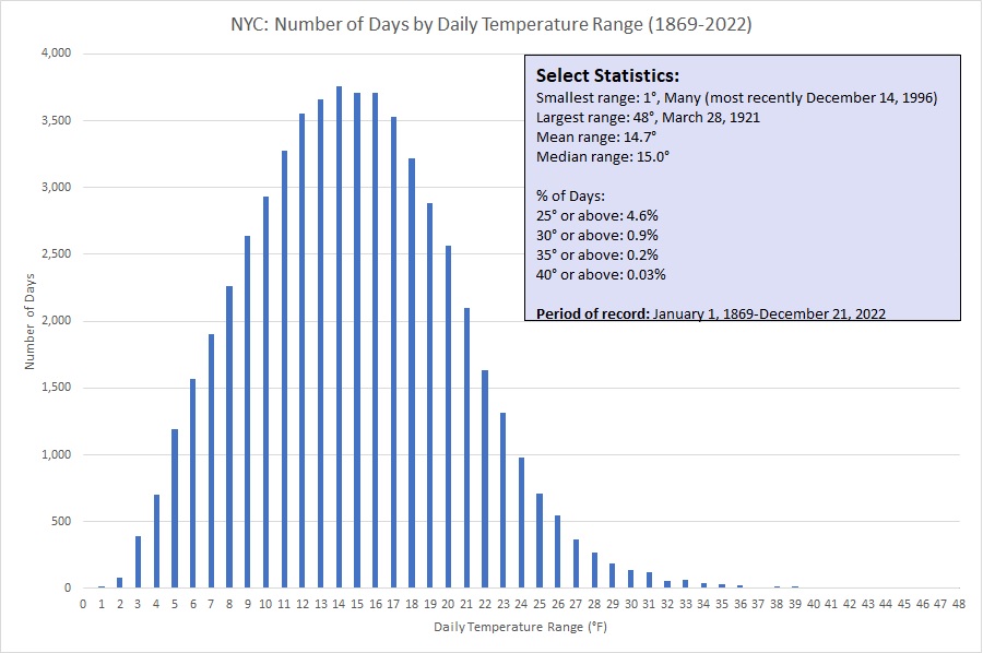
As Arctic air presses into New York City tomorrow, Central Park will likely see a daily temperature range of 30°F or above. Typically, NYC sees 3.3 such days per year. 2022 has seen 3 such days so far: February 4 (31°), February 18 (36°), and February 23 (33°).
-
A powerful storm will continue to bring heavy rain, high winds, and coastal flooding to the region tonight and tomorrow. A storm total 1"-2" of precipitation appears likely with locally higher amounts. A few spots could reach 3" or precipitation. A light snow accumulation remains possible as the storm moves away from the region, largely in interior sections. A flash freeze remains possible tomorrow. In the wake of the storm, the season's coldest air so far will pour into the region. Temperatures will tumble into the teens in in New York City by evening and low teens overnight. Some locations outside the City could see single-digit lows. Nevertheless, the core of the Arctic air mass will bypass the New York City region. Sunday will be fair and continued very cold before slow moderation commences early next week. The AO fell reached -4.000 on December 10th. Since 1950, there were 11 cases that saw the AO reach -4.000 or below during December. Mean snowfall for those cases was 9.0" (Median: 9.1"). 64% of such cases saw 6" or more of snowfall in December while 45% of such cases saw 10.0" or more snow. In contrast, during all other December cases, mean December snowfall was 3.5" (Median: 2.5"). 91% of those cases also saw a colder than normal December in the northern Middle Atlantic region. In terms of seasonal snowfall, 64% of those seasons saw 30" or more snowfall in New York City with 45% having 40" or more. Just 18% of such cases had less than 20" seasonal snowfall, both of which had less than 10" for the December-January period. However, there are cases where Decembers with strong blocking have seen much below normal snowfall. The three cases with less than 1" of monthly snowfall with a monthly average AO of -1.500 or below were: 1985: 0.9" (total seasonal snowfall: 13.0"); 1996: Trace (total seasonal snowfall: 10.0"); and, 2012: 0.4" (total seasonal snowfall: 26.1"). The lowest December snowfall when the AO averaged -2.000 or below was 5.1" in 1976. The lowest winter month snowfall with a monthly average AO of -2.000 or below was 0.5" in January 1998. There is a chance that both futility records could be surpassed this month. The ENSO Region 1+2 anomaly was -0.1°C and the Region 3.4 anomaly was -0.9°C for the week centered around December 14. For the past six weeks, the ENSO Region 1+2 anomaly has averaged -0.95°C and the ENSO Region 3.4 anomaly has averaged -0.92°C. La Niña conditions will likely persist through mid-winter. The SOI was +55.74 today. That smashed the daily record high of +44.34 from 2003. It was also the highest SOI reading since April 2, 2011 when the SOI reached +62.15. The preliminary Arctic Oscillation (AO) was -3.374 today. On December 20 the MJO was in Phase 4 at an amplitude of 0.792 (RMM). The December 19-adjusted amplitude was 0.476 (RMM). Based on sensitivity analysis applied to the latest guidance, there is an implied 87% probability that New York City will have a colder than normal December (1991-2020 normal). December will likely finish with a mean temperature near 37.3° (1.8° below normal).
-
It is. At least for now, that’s the “new normal” for large-scale Arctic blasts.
-
From the November 7-8, 2012 snowstorm following Sandy:
-
New all-time low temperature record: This morning, the temperature fell to -42° at Casper, WY. That smashed the daily record of -33°, which was set in 1983. It also surpassed the December and all-time record of -41° from December 21, 1990.
-
Morning thoughts… A soaking rain will arrive during the late morning or early afternoon hours. High temperatures will reach the upper 40s and lower 50s in most of the region. Likely high temperatures around the region include: New York City (Central Park): 52° Newark: 53° Philadelphia: 54° It will be rainy and windy tomorrow. Afterward, it will turn sharply colder. Normals: New York City: 30-Year: 42.5°; 15-Year: 43.4° Newark: 30-Year: 43.0°; 15-Year: 44.1° Philadelphia: 30-Year: 44.3°; 15-Year: 45.3° The Southern Oscillation Index (SOI) rose to +55.74 today. That is the highest figure since April 2, 2011 when the SOI stood at +62.15.
-
The winter solstice was marked by calm but cold weather. However, the meteorological quiet is about to end. Already, an major Arctic blast is sending temperatures tumbling in the Plains states. Cheyenne went from a high of 42° to a current reading of -12°. Denver saw the temperature dive from a high of 51° to a current figure of -1°. While the cold won't be as severe and its arrival won't be as dramatic late Friday or Friday night, its will send thermometers to their lowest levels so far this winter. A powerful storm will bring heavy rain, high winds, and coastal flooding to the region tomorrow and Friday. The rain will arrive during the late morning or early afternoon. A general 1"-2" of precipitation appears likely with locally higher amounts. A few spots could reach 3" or precipitation. A light snow accumulation remains possible at the onset of the storm and as it moves away from the region, largely in interior sections. A flash freeze remains possible. Once that storm passes, the season's coldest air so far will pour into the region. Temperatures will tumble into the teens in New York City. Nevertheless, the core of the Arctic air mass will bypass the New York City region. The AO fell reached -4.000 on December 10th. Since 1950, there were 11 cases that saw the AO reach -4.000 or below during December. Mean snowfall for those cases was 9.0" (Median: 9.1"). 64% of such cases saw 6" or more of snowfall in December while 45% of such cases saw 10.0" or more snow. In contrast, during all other December cases, mean December snowfall was 3.5" (Median: 2.5"). 91% of those cases also saw a colder than normal December in the northern Middle Atlantic region. In terms of seasonal snowfall, 64% of those seasons saw 30" or more snowfall in New York City with 45% having 40" or more. Just 18% of such cases had less than 20" seasonal snowfall, both of which had less than 10" for the December-January period. However, there are cases where Decembers with strong blocking have seen much below normal snowfall. The three cases with less than 1" of monthly snowfall with a monthly average AO of -1.500 or below were: 1985: 0.9" (total seasonal snowfall: 13.0"); 1996: Trace (total seasonal snowfall: 10.0"); and, 2012: 0.4" (total seasonal snowfall: 26.1"). The lowest December snowfall when the AO averaged -2.000 or below was 5.1" in 1976. The lowest winter month snowfall with a monthly average AO of -2.000 or below was 0.5" in January 1998. There is a chance that both futility records could be surpassed this month. The ENSO Region 1+2 anomaly was -0.1°C and the Region 3.4 anomaly was -0.9°C for the week centered around December 14. For the past six weeks, the ENSO Region 1+2 anomaly has averaged -0.95°C and the ENSO Region 3.4 anomaly has averaged -0.92°C. La Niña conditions will likely persist through mid-winter. The SOI was +37.88 today. The preliminary Arctic Oscillation (AO) was -3.327 today. On December 19 the MJO was in Phase 3 at an amplitude of 0.478 (RMM). The December 18-adjusted amplitude was 0.635 (RMM). Based on sensitivity analysis applied to the latest guidance, there is an implied 85% probability that New York City will have a colder than normal December (1991-2020 normal). December will likely finish with a mean temperature near 37.3° (1.8° below normal).
-
Speaking about temperature drops, the mercury has fallen from 43° at 1:05 pm MST to 10° at 1:15 pm MST at Cheyenne.
-
Morning thoughts… Today will be partly to mostly sunny and cool. High temperatures will reach the upper 30s and lower 40s in most of the region. Likely high temperatures around the region include: New York City (Central Park): 39° Newark: 41° Philadelphia: 41° A soaking rain will arrive tomorrow and continue through Friday. Afterward, it will turn sharply colder. Normals: New York City: 30-Year: 42.8°; 15-Year: 43.6° Newark: 30-Year: 43.3°; 15-Year: 44.3° Philadelphia: 30-Year: 44.5°; 15-Year: 45.6°
-
Dry but cool weather will continue through tomorrow. A powerful storm could bring heavy rain, high winds, and coastal flooding to the region Thursday and Friday. A general 1"-2" of precipitation appears likely with locally higher amounts. A light snow accumulation remains possible at the onset of the storm and as it moves away from the region. A flash freeze is possible. Once that storm passes, the season's coldest air so far will pour into the region. Temperatures could tumble into the teens in New York City. Nevertheless, the core of the Arctic air mass will bypass the New York City region. As a result, New York City's ongoing record 1,419-day streak without a single-digit temperature will be extended. The last time Central Park saw a temperature below 10° was January 31, 2019 when the mercury dipped to 2°. The AO fell reached -4.000 on December 10th. Since 1950, there were 11 cases that saw the AO reach -4.000 or below during December. Mean snowfall for those cases was 9.0" (Median: 9.1"). 64% of such cases saw 6" or more of snowfall in December while 45% of such cases saw 10.0" or more snow. In contrast, during all other December cases, mean December snowfall was 3.5" (Median: 2.5"). 91% of those cases also saw a colder than normal December in the northern Middle Atlantic region. In terms of seasonal snowfall, 64% of those seasons saw 30" or more snowfall in New York City with 45% having 40" or more. Just 18% of such cases had less than 20" seasonal snowfall, both of which had less than 10" for the December-January period. However, there are cases where Decembers with strong blocking have seen much below normal snowfall. The three cases with less than 1" of monthly snowfall with a monthly average AO of -1.500 or below were: 1985: 0.9" (total seasonal snowfall: 13.0"); 1996: Trace (total seasonal snowfall: 10.0"); and, 2012: 0.4" (total seasonal snowfall: 26.1"). The lowest December snowfall when the AO averaged -2.000 or below was 5.1" in 1976. The lowest winter month snowfall with a monthly average AO of -2.000 or below was 0.5" in January 1998. There is a chance that both futility records could be surpassed this month. The ENSO Region 1+2 anomaly was -0.1°C and the Region 3.4 anomaly was -0.9°C for the week centered around December 14. For the past six weeks, the ENSO Region 1+2 anomaly has averaged -0.95°C and the ENSO Region 3.4 anomaly has averaged -0.92°C. La Niña conditions will likely persist through mid-winter. The SOI was +20.19 today. The preliminary Arctic Oscillation (AO) was -3.327 today. On December 18 the MJO was in Phase 3 at an amplitude of 0.636 (RMM). The December 17-adjusted amplitude was 0.642 (RMM). Based on sensitivity analysis applied to the latest guidance, there is an implied 81% probability that New York City will have a colder than normal December (1991-2020 normal). December will likely finish with a mean temperature near 37.6° (1.5° below normal).
-
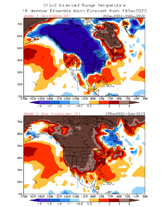
The CFSv2 has a really dramatic flip in weekly anomalies. It is almost as if it has embraced the rule "where there was blue, let there be orange and brown." Yesterday's EPS weeklies had a more muted flip. Whether this is an intermission after what appears likely to be a disappointing opening act to winter despite a notable Arctic blast or something more sinister remains to be seen.
-
Morning thoughts… Today will be partly to mostly sunny and cool. High temperatures will reach mainly the upper 30s in most of the region. Likely high temperatures around the region include: New York City (Central Park): 38° Newark: 40° Philadelphia: 39° The dry weather will continue through tomorrow. Normals: New York City: 30-Year: 43.0°; 15-Year: 43.8° Newark: 30-Year: 43.5°; 15-Year: 44.5° Philadelphia: 30-Year: 44.8°; 15-Year: 45.8°
-
I agree with this quibble. I’ve sometimes mentioned sample size limitations and probably, but should do so more often. I note some cases/examples, e.g., 1958-58 in my commentary for purposes of illustration, but avoid references to analogs, as such references would go beyond the strength of relationships. Even an outcome that is 50% above climatology can still be a fairly low probability outcome. 10”+ snowstorms are uncommon events by any measure. Skill clearly dissipates as timeframes grow. Coefficients of determination also leave large parts of explanation beyond limited numbers of variables, especially as one considers the synoptic scale. Further complicating things is the reality of a dynamic climate that is altering existing relationships among variables. In the extended range, to use an analogy, one is always peering into the fog or mist of uncertainty. That’s why I embrace probabilistic language such as “likely,” and like CPC’s approach. Finally, models and ensembles have come far—and they consistently outperform the human level of skill—but they still have real limits. Machine learning/AI holds additional promise. How to convey the inherent uncertainty and limitations is a continuing question. I don’t have definitive answers to this question. Critiques are both welcome and helpful.
-
Given all the discussion in this thread--expressions of disappointment and frustration with the pattern evolution--I reviewed my posts concerning the ongoing pattern evolution for December 2022. I appear to have generally highlighted the need for caution. In addition, I mentioned unfavorable outcomes on multiple occasions. But some improvements could have been made, as noted later. As noted previously, forecasting in the medium-range and extended-range should be viewed in probabilistic, not deterministic terms. I've cited how I believe CPC's probabilistic approach to its 6-10-day, 8-14-day, and experimental 3-4-week forecasts is the way to go. I vigorously disagree with critics who proclaim that probabilistic forecasts are not forecasts. They are. That the critics don't appreciate or understand the application of probabilities is a completely separate issue. I will note that on social media, particularly Twitter and Facebook, sensationalism remains a genuine issue. Indeed, one tweet even suggested that the coming Great Lakes storm for December 22-24 could be analogous to a combination of the March 1993 superstorm and Blizzard of 1996. The former would be reasonable given the deepening that has been modeled and is still modeled. The latter was favored by only a small number of ensemble members (9/51 EPS members once favored 10" or more snow for NYC--a plurality but not majority--but just two showed 18" or more snow). What is said on social media is beyond what is discussed in this thread here. Social media should not skew perceptions of what is discussed in this thread or elsewhere on AmericanWx. @bluewave had repeatedly expressed a lot of caution, as well. Quite frankly, some of the information in this thread has consistently demonstrated greater insight, knowledge, and expertise than some of the sensationalist posts on Twitter (blizzard of 1996-type calls, 1983/1989-magnitude Arctic outbreak, etc.). Moreover, that's the norm when this forum is compared to Twitter and other social media forums. I don't like to have to make such comparisons, but it seems that social media perceptions have skewed perceptions of the better-informed discussions here, so pointing out the contrast is necessary and informative. And yes, "better-informed" is a deliberately-chosen accurate description. Facts, not sentimentalities, are vital. Having said that, perhaps on my end, I could have been more forceful in highlighting the level of uncertainty and risks for unfavorable outcomes. That this could be the first winter month on record (since 1950 when daily teleconnections data has been available) to see no measurable snowfall in NYC or Philadelphia despite a likely monthly average AO of -2.000 or below speaks to the uncommon nature of what is possibly going to unfold. No measurable snowfall is not yet assured, but the probability of that outcome has increased. Numerous examples from this thread follow. December 1: Potential could increase. Percentages provided for days with measurable snowfall and 1" or more snowfall for Boston, New York City, and Philadelphia: https://www.americanwx.com/bb/topic/58472-december-2022/?do=findComment&comment=6709110 Daily Discussion: "With the development of an EPO-/AO-/PNA- pattern, colder air intrusions could become more frequent after the first week of December. The potential for snowfall could also begin to increase." https://www.americanwx.com/bb/topic/58472-december-2022/?do=findComment&comment=6709893 Outcome: December 11-12: Snow coated the ground outside of New York City, including Newark (0.1") and Islip (0.4"). LaGuardia Airport also picked up 0.4" of snow. Another storm brought a moderate to significant snowfall to interior parts of the Northeast during the December 15-18 period, but none to the immediate New York City-Newark areas. December 2: Blocking patterns can take a long time to deliver snowstorms. November-December 2010 was provided as an example. https://www.americanwx.com/bb/topic/58472-december-2022/?do=findComment&comment=6711095 December 3: PNA: "By the end of the third week in December, values should be less negative than they currently are. However, the development of sustained positive values by that time seems unlikely (not zero, but still a less than one-in-three probability)." https://www.americanwx.com/bb/topic/58472-december-2022/?do=findComment&comment=6711896 Outcome: Through December 19, the PNA has remained < 0 December 3: "With the development of an EPO-/AO-/PNA- pattern following a short-lived rebound in the EPO to positive levels, colder air intrusions could again become more frequent toward mid-December. The potential for snowfall could also begin to increase, as well, as a sustained colder pattern begins to develop, but significant snowfall is not likely during the transition to that colder pattern." https://www.americanwx.com/bb/topic/58472-december-2022/?do=findComment&comment=6712062 December 5: "With the development of an EPO-/AO-/PNA- pattern following a short-lived rebound in the EPO to positive levels, colder air intrusions could again become more frequent toward mid-December. The potential for snowfall could also begin to increase, as well, as a sustained colder pattern begins to develop, but significant snowfall is not likely during the transition to that colder pattern. No severe cold is likely through at least the first three weeks of December. The latest EPS weeklies suggest that near normal to below normal temperatures could prevail during the December 19-26 period." https://www.americanwx.com/bb/topic/58472-december-2022/?do=findComment&comment=6714130 December 11: "A sustained colder pattern is currently developing. The latest EPS weeklies continue to suggest that near normal to below normal temperatures could prevail during the December 19-26 period. No severe cold is likely through at least the first three weeks of December. Afterward, as the PNA goes neutral, the prospect for snowfall and more significant cold could increase." https://www.americanwx.com/bb/topic/58472-december-2022/?do=findComment&comment=6722294 Outcome: 7 of the last 9 days have been cooler than normal in New York City (through December 19th). No severe cold has occurred through December 19th. December 13: "The probability of snowfall (measurable and significant) is notably higher than climatology during strong blocking patterns, especially when the PNA is positive at this time of year (and all of January). Higher probabilities are not guarantees. While the extreme blocking during 2010-2011 led to a big December blizzard and very snowy 30 days albeit after a long wait from late November, there have been cases where strong blocking did not produce such an outcome. Winter 1958-1959 is one such example." https://www.americanwx.com/bb/topic/58472-december-2022/?do=findComment&comment=6724692 December 15: "Here's what the two largest clusters look like for 12/23 (the first with 19 members has a Miller B-type scenario and probably comprises all 9 of the individual members showing 10" or more snow in the NYC-EWR areas; the second large group is very unfavorable for the coastal plain)." https://www.americanwx.com/bb/topic/58472-december-2022/?do=findComment&comment=6728734 Note: 9 of 51 EPS (17.6%) members showed 10" or more snow for the December 22-24 period at the time. December 16: "Phasing events are complex and details matter greatly. At extended ranges, even the best models don't fully resolve the details. With the PNA forecast to be rising to neutral or somewhat positive levels coupled with a strongly negative AO, the region has its highest probability relative to climatology for at least an appreciable snowfall. Nearly half of all December 16-31 days with 4" or more snowfall in either New York City, Newark, or Philadelphia during 1950-2021 have occurred with an AO-/PNA+ pattern (and two thirds of storms with daily snowfall of 4" or more in all three cities). There are no guarantees, of course. Some similar patterns deliver very little (December 1950). Others deliver large amounts of snow (December 2010 into January 2011)." https://www.americanwx.com/bb/topic/58472-december-2022/?do=findComment&comment=6732883 December 16: "Late next week could see another storm bring precipitation to the region. Model solutions range from accumulating snow in the New York City-Newark area to a potential Ohio Valley/Great Lakes blizzard. Details remain to be sorted out, but the latter scenario is currently the favored one on the ensembles. Once that storm passes, the season's coldest air so far will pour into the region." https://www.americanwx.com/bb/topic/58472-december-2022/?do=findComment&comment=6734163 December 17: "A powerful storm could bring heavy rain, high winds, and coastal flooding to the region late next week. A light snow accumulation remains possible at the onset of the storm and as it moves away from the region. Once that storm passes, the season's coldest air so far will pour into the region. Temperatures could tumble into the teens in New York City." https://www.americanwx.com/bb/topic/58472-december-2022/?do=findComment&comment=6737090


