

donsutherland1
-
Posts
24,192 -
Joined
Content Type
Profiles
Blogs
Forums
American Weather
Media Demo
Store
Gallery
Everything posted by donsutherland1
-
Thanks for sharing the memory.
-
Even in a lower snow regime, there will sometimes be big snowstorms. Washington, DC is essentially where Richmond was in the early 20th century. It can still have snowy winters, but those will be less frequent than they once were.
-
In New York City, winters are warming, the measurable snow season is shrinking in length, and the average number of events is falling. However, the benefits of added moisture (warm air holds more moisture) has contributed to rising seasonal snowfall as the average event is now larger. There will come a time when the warming is sufficiently great to offset the benefits of added moisture. That process is underway in Washington, DC, but not Philadelphia or New York. It could be another decade or two before such a trend develops in Philadelphia and New York City (an additional 1.0°-1.5° of winter warming is likely needed if Washington's data is representative). As we move toward that inflection point, one will probably see greater variability between high snow and very low snowfall winters, the latter will often be exceptionally warm even against the 1991-2020 reference period.
-
That was 2001-02. 2000-01 was a snowy winter.
-
Yes. The record fewest such days in January is 4. That occurred in 1932.
-
It would start during the second week of February. It's tough to pin down the exact dates. Then, it could continue for 1-2 weeks, but skill drops off sharply, so we'll have to see where things stand. There is some support on yesterday's EPS weeklies for such an outcome.
-
It's tough to know, as the La Niña is beginning to fade, though discontinuously. I suspect that we'll see at least 1-2 weeks of above normal temperatures once the warmup occurs. Late February-early March might hold some additional opportunities for snowfall, if some past La Niña winters are representative.
-
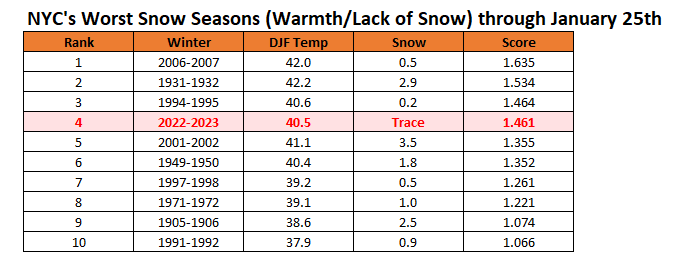
New York City's snow season futility rankings through January 25th:
-
I think we’ll make it to the 1st. There may then be a window of opportunity for some snow during the first week of February before it warms up again during the following week.
-
Tomorrow and Saturday will be partly sunny and mild days. Saturday could see the mercury approach or reach 50° in New York City. New York City is now on track to see its latest ever first measurable snowfall of the season. The existing record of January 29th was set in 1973. There is a distinct possibility that New York City could get through all of January without a measurable snowfall. A cooler pattern will move in during the first week of February and last through the week. Afterward, moderation could begin to occur during the second week of the month. The ENSO Region 1+2 anomaly was -0.3°C and the Region 3.4 anomaly was -0.6°C for the week centered around January 11. For the past six weeks, the ENSO Region 1+2 anomaly has averaged -0.30°C and the ENSO Region 3.4 anomaly has averaged -0.75°C. La Niña conditions are beginning to fade and they should evolve to neutral conditions during late winter or early spring. The SOI was +4.01 today. The preliminary Arctic Oscillation (AO) was +0.596 today. On January 24 the MJO was in Phase 3 at an amplitude of 1.590 (RMM). The January 23-adjusted amplitude was 1.544 (RMM). Based on sensitivity analysis applied to the latest guidance, there is an implied near 100% probability that New York City will have a warmer than normal January (1991-2020 normal). January will likely finish with a mean temperature near 42.3° (8.6° above normal). That will rank January 2023 as the second warmest January on record.
-
Islip tied the daily record high of 55 yesterday. That record was set in 2010 during a snowier winter than the current one.
-
Occasional Thoughts on Climate Change
donsutherland1 replied to donsutherland1's topic in Climate Change
It’s very likely not credible. The journal is listed among predatory journals. https://beallslist.net -
That’s terrible. I’m sorry to hear of this.
-
Perhaps a short shot of below normal temperatures. Nothing really severe.
-
It should be dry for the remainder of January once the ongoing storm moves away.
-
We’ll need the lows to be higher.
-
I think we'll fall short.
-
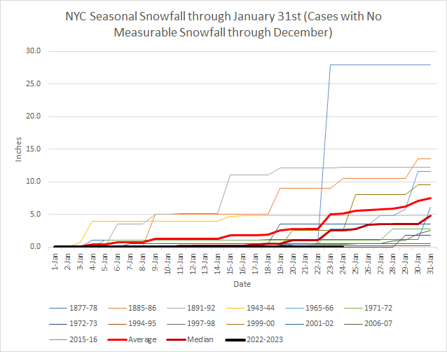
Another storm is bringing precipitation to the New York City area. As has been the theme this winter, at least so far, there has been no measurable snow. Seemingly, back in 2000, country singer Jo Dee Messina nailed New York City's forecast before the January 25 6z GFS did with her "Bring on the rain." New York City wound up picking up just a trace of snow. That extended its measurable snow drought to 322 consecutive days, which ranks as the second longest such stretch on record. New York City is now on track to see its latest ever first measurable snowfall of the season. The existing record of January 29th was set in 1973. There is a distinct possibility that New York City could get through all of January without a measurable snowfall. A cooler pattern will move in during the first week of February and last through the week. Afterward, moderation could begin to occur during the second week of the month. The ENSO Region 1+2 anomaly was -0.3°C and the Region 3.4 anomaly was -0.6°C for the week centered around January 11. For the past six weeks, the ENSO Region 1+2 anomaly has averaged -0.30°C and the ENSO Region 3.4 anomaly has averaged -0.75°C. La Niña conditions are beginning to fade and they should evolve to neutral conditions during late winter or early spring. The SOI was +14.61 today. The preliminary Arctic Oscillation (AO) was +0.545 today. On January 23 the MJO was in Phase 3 at an amplitude of 1.541 (RMM). The January 22-adjusted amplitude was 1.525 (RMM). Based on sensitivity analysis applied to the latest guidance, there is an implied near 100% probability that New York City will have a warmer than normal January (1991-2020 normal). January will likely finish with a mean temperature near 42.0° (8.3° above normal).
-
Today would be the 322nd day.
-
Yes, the record is 332 consecutive days.
-
Occasional Thoughts on Climate Change
donsutherland1 replied to donsutherland1's topic in Climate Change
Yes, he’s fallen far. -
We almost had <1” in 1997-98. I suspect that we’ll avoid such a sad outcome this winter. But a lot can still go wrong.
-
The 2.5” shown for today won’t verify. And that’s from today’s 6z run!
-
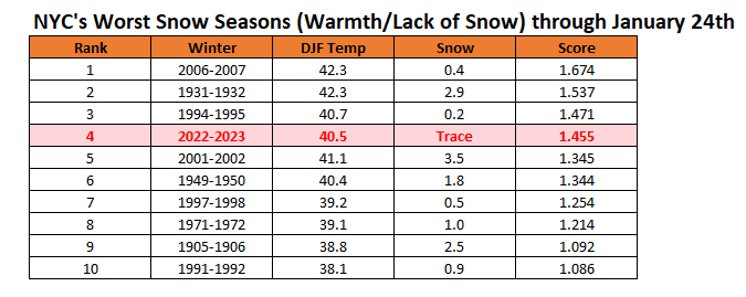
Snow season futility rankings through January 24th.
-
Thanks for sharing.

