

donsutherland1
-
Posts
24,192 -
Joined
Content Type
Profiles
Blogs
Forums
American Weather
Media Demo
Store
Gallery
Everything posted by donsutherland1
-
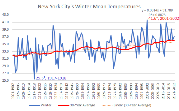
That’s long-term. The rate of warming has accelerated in recent decades. At the current rate, NYC’s mean winter temperature should reach 37 during the 2030s. At that level, NYC should still have snowy winters, but they would be fewer in number; low snowfall winters would increase in number. The mean winter snowfall would fall to near 20”. This assumes that the experience with that temperature is similar to that elsewhere in the Mid-Atlantic where it has been reached.
-
Warming winters in New York City: Winter 2022-2023 will be the 8th consecutive winter that is warmer than the moving 30-year average
-
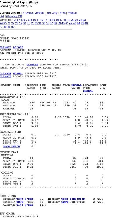
A storm passing well to the south of the region could bring some rain and wind to the coastal plain tomorrow into Monday. The heaviest precipitation will fall south and east of New York City, along the Jersey shore and parts of Long Island. In contrast, higher elevations in eastern Tennessee, western North Carolina, West Virginia, and western Virginia could pick up an appreciable snowfall. In the wake of the storm, much milder air will return to the region. The potential exists for temperatures to run generally above to much above normal past mid-month. Both the CFSv2 and EPS weeklies show much above normal temperatures into the third week of February. Afterward, temperatures could cool during the closing 7 days of the month. No severe shots of cold appear likely into late February. Among the extended range scenarios on the table is a late February-early March 2002-type outcome. Under such a scenario, cold air would flood into the Plains States, but persistent southeast ridging would keep most of the cold away from the northeastern and Mid-Atlantic United States. During February 28-March 5, 2002 high temperatures in the New York City area generally reached the lower to middle 40s with low temperatures in the 20s at night. At the height of the cold, one night saw the temperature fall into the upper teens. By March 7, the cold was gone and readings return to much above normal levels. In terms of ENSO, the ENSO Region 1+2 anomaly went positive for the week centered around February 1st. That is the first positive reading since a +0.2 anomaly during the week centered around October 6, 2021. The ENSO Region 1+2 anomaly was +0.1°C and the Region 3.4 anomaly was -0.5°C for the week centered around February 1. For the past six weeks, the ENSO Region 1+2 anomaly has averaged -0.23°C and the ENSO Region 3.4 anomaly has averaged -0.65°C. La Niña conditions are beginning to fade and they should evolve to neutral conditions during late winter or early spring. The SOI was +21.37 today. The preliminary Arctic Oscillation (AO) was +2.145 today. On February 9 the MJO was in Phase 4 at an amplitude of 1.924 (RMM). The February 8-adjusted amplitude was 1.963 (RMM). Based on sensitivity analysis applied to the latest guidance, there is an implied 93% probability that New York City will have a warmer than normal February (1991-2020 normal). February will likely finish with a mean temperature near 40.1° (4.2° above normal).
-
There was a big increase in the expected February mean temperature on the sensitivity analysis of the guidance. This hints that some of the long-range modeling has backed off a dramatic turn toward colder conditions in late February. Perhaps the shift to near normal readings on the week 3 ECMWF guidance might be reasonable? Skill scores are low at that range, but the magnitude of the shift toward a warmer monthly figure is not common. This development also raises questions about some of the cold/snowy March analogs being pushed on Twitter. Let’s see if there’s continuity in coming days.
-
Morning thoughts… Today will be partly sunny, breezy, and cooler. High temperatures will reach the middle 40s in most areas. Likely high temperatures around the region include: New York City (Central Park): 45° Newark: 47° Philadelphia: 47° A storm passing well south of the region could bring some light rain and wind. Most of the rain will fall from New York City south and eastward. Normals: New York City: 30-Year: 41.4°; 15-Year: 41.4° Newark: 30-Year: 42.1°; 15-Year: 42.2° Philadelphia: 30-Year: 43.4°; 15-Year: 43.2°
-
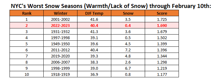
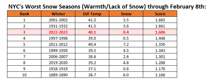
New York City's snow season futility rankings through February 10th: Winter 2022-2023 climbs to second place
-
Islip was warmer than all of the New York City sites and Newark.
-
The high was 62.
-
Under bright sunshine and a fresh breeze, much of the region experienced near record and record warmth. Daily records included: Atlantic City: 63° (old record: 60°, 1959 and 2001) Baltimore: 66° (tied record set in 1959 and tied in 1960) Boston: 60° (tied record set in 1990) Bridgeport: 62° (old record: 54°, 2001) Hartford: 62° (old record: 55°, 1909) Islip: 62° (old record: 56°, 2022) New Haven: 62° (old record: 53°, 2022) New York City-JFK: 60° (old record: 56°, 2001 and 2022) New York City-LGA: 60°, 2001 (tied record set in 2001) New York City-NYC: 61° (tied record set in 1990 and tied in 2001) Portland: 52° (tied record set in 1955) Providence: 64° (old record: 58°, 1909) Raleigh: 75° (tied record set in 1899 and tied in 1938) Scranton: 57° (tied record set in 1909 and tied in 1955) Sterling, VA: 65° (old record: 63°, 1990 and 2001) Westhampton: 62° (old record: 56°, 2001) White Plains: 59° (old record: 55°, 2001) Wilmington, NC: 80° (old record: 77°, 1932 and 1965) Worcester: 56° (old record: 55°, 1909) A storm passing well to the south of the region could bring some rain and wind to the coastal plain Sunday into Monday. The heaviest precipitation will fall south and east of New York City, along the Jersey shore and parts of Long Island. Afterward, much milder air will return to the region. The potential exists for temperatures to run generally above to much above normal through mid-month. Both the CFSv2 and EPS weeklies show much above normal temperatures into the third week of February. Afterward, temperatures could cool during the closing 7-10 days of the month. There remains some disagreement among the ensembles about whether it will turn colder for a sustained period or just briefly, as well as with regard to the magnitude of the cold. In terms of ENSO, the ENSO Region 1+2 anomaly went positive for the week centered around February 1st. That is the first positive reading since a +0.2 anomaly during the week centered around October 6, 2021. The ENSO Region 1+2 anomaly was +0.1°C and the Region 3.4 anomaly was -0.5°C for the week centered around February 1. For the past six weeks, the ENSO Region 1+2 anomaly has averaged -0.23°C and the ENSO Region 3.4 anomaly has averaged -0.65°C. La Niña conditions are beginning to fade and they should evolve to neutral conditions during late winter or early spring. The SOI was +21.85 today. The preliminary Arctic Oscillation (AO) was +2.145 today. On February 8 the MJO was in Phase 4 at an amplitude of 1.970 (RMM). The February 7-adjusted amplitude was 2.003 (RMM). Based on sensitivity analysis applied to the latest guidance, there is an implied 87% probability that New York City will have a warmer than normal February (1991-2020 normal). February will likely finish with a mean temperature near 39.3° (3.4° above normal).
-
Bridgeport, Islip, New Haven, all three New York City sites, and White Plains have tied or broken their daily records.
-
Earlier today, NYC tied its daily record of 61. That record was set in 1990 and tied in 2001.
-
Morning thoughts… Unseasonable warmth covers parts of the region that saw the warm front move through last night. Already, White Plains reached a record 56° (old record: 55°, 2001). Today will be partly sunny, breezy, and unseasonably warm. High temperatures will reach the upper 50s and lower 60s in most areas. Likely high temperatures around the region include: New York City (Central Park): 60° Newark: 58° Philadelphia: 58° It will turn cooler for the weekend. Normals: New York City: 30-Year: 41.2°; 15-Year: 41.2° Newark: 30-Year: 41.9°; 15-Year: 42.0° Philadelphia: 30-Year: 43.2°; 15-Year: 43.0°
-
New York City's snow season futility rankings through February 9th. For @Roger Smith, 1992-1993 ranked 18th.
-
Today the temperature rose to a near record 68° in Baltimore. That warm air is now pushing northward. As a rsult, the temperature could spike into the upper 50s and lower 60s tomorrow before cooler air returns. Daily records include: Bridgeport: 54°, 2001 Islip: 56°, 2022 New Haven: 53°, 2022 New York City-JFK: 56°, 2001 and 2022 New York City-LGA: 60°, 2001 New York City-NYC: 61°, 1990 and 2001 Newark: 63°, 1990 Philadelphia: 65°, 1925 White Plains: 55°, 2001 A storm passing well to the south of the region could bring some rain and wind to the coastal plain with a small chance of some frozen precipitation in the interior Sunday into Monday. Afterward, much milder air will return to the region. The potential exists for temperatures to run generally above to much above normal through mid-month. Both the CFSv2 and EPS weeklies show much above normal temperatures through the second week of February. Afterward, temperatures could cool during the closing 7-10 days of the month. There remains some disagreement among the ensembles about whether it will turn colder for a sustained period or just briefly, as well as with regard to the magnitude of the cold. In terms of ENSO, the ENSO Region 1+2 anomaly went positive for the week centered around February 1st. That is the first positive reading since a +0.2 anomaly during the week centered around October 6, 2021. The ENSO Region 1+2 anomaly was +0.1°C and the Region 3.4 anomaly was -0.5°C for the week centered around February 1. For the past six weeks, the ENSO Region 1+2 anomaly has averaged -0.23°C and the ENSO Region 3.4 anomaly has averaged -0.65°C. La Niña conditions are beginning to fade and they should evolve to neutral conditions during late winter or early spring. The SOI was +17.15 today. The preliminary Arctic Oscillation (AO) was +2.229 today. On February 7 the MJO was in Phase 4 at an amplitude of 2.003 (RMM). The February 6-adjusted amplitude was 1.832 (RMM). Based on sensitivity analysis applied to the latest guidance, there is an implied 79% probability that New York City will have a warmer than normal February (1991-2020 normal). February will likely finish with a mean temperature near 39.0° (3.1° above normal).
-
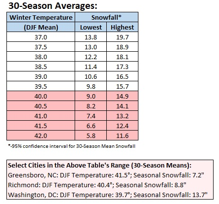
That may well be the case. However, the difference probably wouldn't be too great. For an example, I looked at Lynchburg, VA (2021 population: 79,009) for an idea of how a smaller location would fare. Lynchburg, which was not part of the dataset, has had 30-season winter temperatures in the 37.0° or above threshold for 88 years albeit with some cases below that threshold. The average snowfall during that time was 14.4". The predicted value (mid-point between the 95% confidence limits) was also 14.4". Overall, 56% of seasons had a mean snowfall below predicted value and 44% had a mean snowfall above the predicted value. Only 5/88 (6%) of seasons had snowfall outside the confidence interval (very close to the statistical 5% figure. For the 30-season average ending with Winter 2021-2022, Lynchburg has a winter mean temperature of 38.1°. Mean seasonal snowfall is 14.1". The predicted value is 14.5". The actual figure falls just below the mid-point of the 95% confidence interval.
-
Unfortunately, many of these communities outside of NYC don’t have climate data.
-
Winter 2022-2023 has been exceptionally warm and remarkably snow-free in the northern Middle Atlantic region. Through February 8th, New York City has seen its lowest seasonal snowfall on record and Philadelphia has seen its second lowest figure. The current "normal" values are: New York City: DJF mean temperature: 36.2°; mean seasonal snowfall: 29.8" Philadelphia: DJF mean temperature: 36.1°; mean seasonal snowfall: 23.2" This raises a question. What will seasonal snowfall look like in the warmer winters to come over the next two decades? The winters in the lower Middle Atlantic region provide some insight. Therefore, I created a dataset comprised of all the winters in Norfolk, Raleigh, and Richmond. The dataset was comprised of 30-season mean winter (December-February) temperatures and 30-season mean snowfall (July 1-June 30). All of those winters had 30-season mean winter temperature averages of 37.0° or above. Washington, DC had also seen its 30-season mean winter temperatures reach and exceed 37.0°. All 30-season mean winter temperatures of 37.0° or above and the corresponding mean seasonal snowfall were added to the dataset. The sample size was 319. The next step involved creating a regression equation from the dataset. Once that was done, seasonal snowfall ranges based on 95% confidence intervals were constructed. The coefficient of determination was 0.836. At least two caveats apply: 1. The regional climate (precipitation, proximity to the Atlantic Ocean, etc..) differ somewhat in the northern Mid-Atlantic region from the area from which the dataset was constructed. 2. The northern Mid-Atlantic region has closer proximity to Canada and, even warm winters, could see stronger pushes of cold air. Finally, to see how things might be playing out relative to the expectations from the regression equation, I examined winters with mean temperatures of 37.0° or above and 40.0° or above in New York City and Philadelphia. These are individual winters and are not equivalent to 30-season averages. They also fall into colder regimes, which could skew seasonal snowfall higher. Sample size issues, especially with the warmest (40.0° or warmer) winters arise e.g., Winter 2015-2016, which saw a historic snowstorm, skews the mean figure for the small sample sizes. For Winters with a Mean Temperature of 37.0° or Above: New York City: Mean Temperature: 38..4°; Mean Snowfall: 18.1" Philadelphia: Mean Temperature: 38.9°; Mean Snowfall: 13.0" For Winters with a Mean Temperature of 40.0° or Above: New York City: Mean Temperature: 40.8°; Mean Snowfall: 12.3" Philadelphia: Mean Temperature: 41.2°; Mean Snowfall: 11.1"
-
Morning thoughts… Today will be mostly cloudy and mild. A few locations could see a shower. High temperatures will reach the upper 40s and lower 50s in most areas. Southern New Jersey and southeastern Pennsylvania could see the mercury reach or exceed 60°. Likely high temperatures around the region include: New York City (Central Park): 53° Newark: 56° Philadelphia: 61° It will be unseasonably mild through Friday. Normals: New York City: 30-Year: 41.0°; 15-Year: 41.1° Newark: 30-Year: 41.7°; 15-Year: 41.9° Philadelphia: 30-Year: 43.0°; 15-Year: 42.9°
-
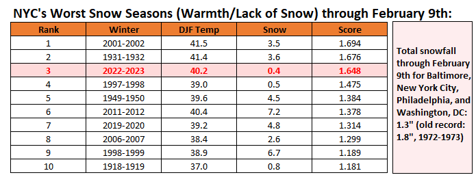
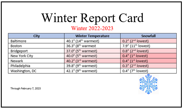
New York City's snow season futility rankings through February 8th:
-
It wouldn’t take too much to get to 40. If the CFSv2 is reasonably accurate, we would get there. But skill is low beyond 2 weeks.
-
Tomorrow will be mostly cloudy. Some rain is possible. The temperature will slowly rise through the 40s during the day and into the 50s during the evening. The temperature could spike into the upper 50s and perhaps even the lower 60s on Friday before cooler air returns. A storm passing well to the south of the region could bring rain and wind to the coastal plain with a small chance of some frozen precipitation in the interior Sunday into Monday. Afterward, much milder air will return to the region. The potential exists for temperatures to run generally above to much above normal through mid-month. Both the CFSv2 and EPS weeklies show much above normal temperatures through the second week of February. Afterward, temperatures could cool during the closing 7-10 days of the month. There is disagreement among the ensembles about whether it will turn colder for a sustained period or just briefly, as well as with regard to the magnitude of the cold. In terms of ENSO, the ENSO Region 1+2 anomaly went positive for the week centered around February 1st. That is the first positive reading since a +0.2 anomaly during the week centered around October 6, 2021. The ENSO Region 1+2 anomaly was +0.1°C and the Region 3.4 anomaly was -0.5°C for the week centered around February 1. For the past six weeks, the ENSO Region 1+2 anomaly has averaged -0.23°C and the ENSO Region 3.4 anomaly has averaged -0.65°C. La Niña conditions are beginning to fade and they should evolve to neutral conditions during late winter or early spring. The SOI was +16.91 today. The preliminary Arctic Oscillation (AO) was +2.647 today. On February 6 the MJO was in Phase 4 at an amplitude of 1.829 (RMM). The February 5-adjusted amplitude was 1.804 (RMM). Based on sensitivity analysis applied to the latest guidance, there is an implied 78% probability that New York City will have a warmer than normal February (1991-2020 normal). February will likely finish with a mean temperature near 39.0° (3.1° above normal).
-
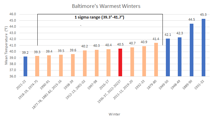
Here's Baltimore's:
-
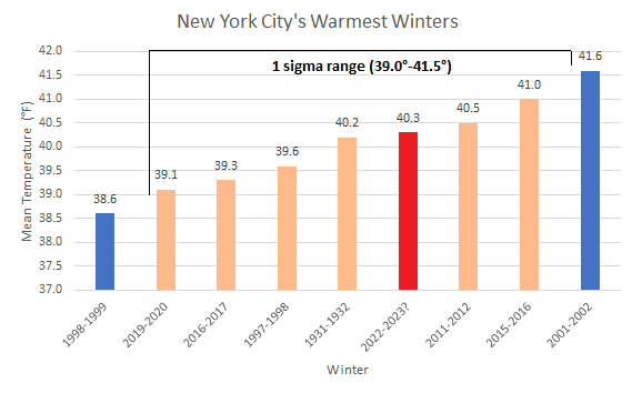
Winter 2022-2023 is on course to rank among the five warmest winters on record in New York City:
-
Where is winter? Seemingly nowhere near the New York City-Philadelphia areas.
-
Morning thoughts… Today will be partly sunny and milder. High temperatures will reach the lower 50s in most areas. Likely high temperatures around the region include: New York City (Central Park): 51° Newark: 53° Philadelphia: 54° It will be unseasonably mild through Friday. Normals: New York City: 30-Year: 40.9°; 15-Year: 40.9° Newark: 30-Year: 41.6°; 15-Year: 41.7° Philadelphia: 30-Year: 42.8°; 15-Year: 42.7°


