

donsutherland1
-
Posts
24,193 -
Joined
Content Type
Profiles
Blogs
Forums
American Weather
Media Demo
Store
Gallery
Everything posted by donsutherland1
-
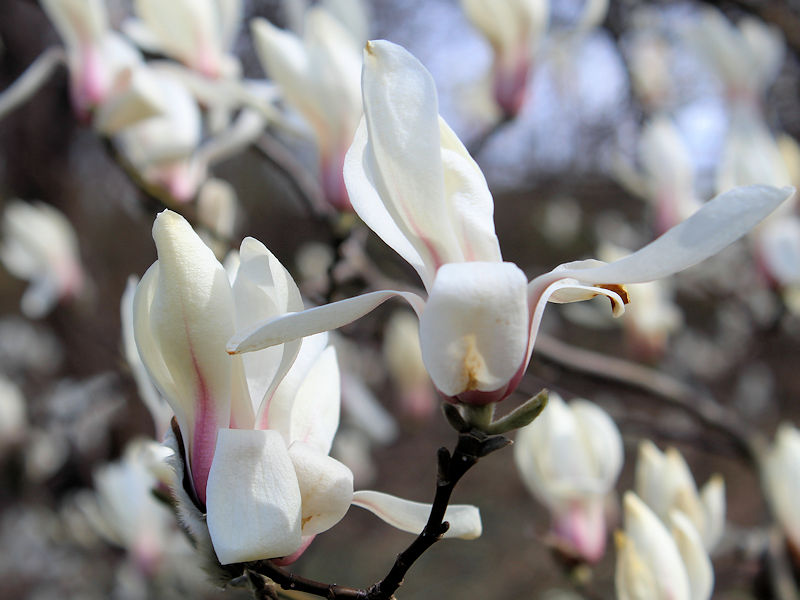
Nature has now made an irreversible commitment to spring at the New York Botanical Garden. Below are some photos from this afternoon:


-
The question is whether the ad revenue begins to dry up when his repeated forecasting debacles become evident. Already, some meteorologists, including former Accuweather colleagues, are starting to call out his failures on Social Media.
-
Pursuing clicks at the expense of one's credibility is not a good trade-off. The costs far exceed the short-term benefits once one's credibility is lost. Loss of credibility is damaging to one's professional reputation.
-
Unfortunately, ISP’s period of record doesn’t go back to 1956. Data from Patchogue (2 N) is available: March 16-17: 4.2" March 18-19: 12.4"
-
There were back-to-back storms on March 16-17 and March 18-19. It was an epic finish to the winter.
-
Morning thoughts… Clouds will give way to bright sunshine. High temperatures will reach the lower 50s in most of the region. Likely high temperatures around the region include: New York City (Central Park): 52° Newark: 54° Philadelphia: 53° Tomorrow will be unseasonably cool, but milder air will return on Monday and remain in place through the remainder of the week. Normals: New York City: 30-Year: 50.3°; 15-Year: 51.0° Newark: 30-Year: 51.3°; 15-Year: 52.3° Philadelphia: 30-Year: 53.3°; 15-Year: 54.0°
-
Early clouds will yield to sunshine tomorrow. It will turn breezy and a brief shot of cold will overspread the region for Sunday. Afterward, temperatures will rebound. Model support has continued to increase for a sustained turn toward milder weather next week. Some uncertainty still exists, but the overall probability that March could finish near or somewhat warmer than normal has increased dramatically in recent days. No potential snowstorms appear likely through at least the end of next week. New York City is currently on a path that could culminate in its setting a new low seasonal snowfall record. Historic experience with very low snowfall totals through February argues that a very snowy March or big snowstorm during March or April are unlikely. There were 16 winters that had less than 8" of snowfall through February in New York City. Just two (13%) had a 6" or greater snowstorm during March or April: 1889-1890: 6.0" on March 19th and 1991-1992: 6.2" on March 19th. With just 2.3" snowfall through March 16, New York City has a high probability of finishing with less than 10" of snow. Since 1869-70, 88% of winters with less than 8" of snow through March 16 wound up with less than 10" seasonal snowfall. The highest seasonal amount in such cases occurred in 1991-1992 when 12.6" of snow was measured. By March 19th, all 10 winters with less than 8.5" of snow wound up with less than 10" of seasonal snowfall. The ENSO Region 1+2 anomaly was +1.5°C and the Region 3.4 anomaly was -0.1°C for the week centered around March 8. For the past six weeks, the ENSO Region 1+2 anomaly has averaged +0.76°C and the ENSO Region 3.4 anomaly has averaged -0.35°C. Neutral ENSO conditions will likely prevail through at least mid-spring. The SOI was -4.64 today. The preliminary Arctic Oscillation (AO) was -0.087 today. On March 15 the MJO was in Phase 1 at an amplitude of 3.125 (RMM). The March 14-adjusted amplitude was 3.532 (RMM). Based on sensitivity analysis applied to the latest guidance, there is an implied 60% probability that New York City will have a warmer than normal March (1991-2020 normal). March will likely finish with a mean temperature near 43.3° (0.5° above normal normal).
-
He was once a very good forecaster. Unfortunately, he failed to adapt his framework and approach to address the forecasting realities of today's warmer world. The reduced pool of cold air coverage, higher incidence of pattern-influencing marine heatwaves, greater atmospheric moisture content, the rise of quasi-resonant amplification, etc. have fundamentally altered the forecasting context. What worked well in the 1990s or even very early 2000s doesn't work so well today. Analogs constructed from the earlier climate regime have lost relevance. Objectivity is a prerequisite for recognizing the shift that has taken place and its implications. Flexibility is necessary to revise one's forecasting framework and approach. Denial or refusal to accept the changes that have occurred and rigidity in forecasting frameworks and approaches assure one's inability to adapt when the change takes place, as it has. In the end, forecasting greatness is determined over time and is best distinguished in the capacity of a forecaster to successfully adapt to change. A forecaster who makes the successful transition from one forecasting context to another one while continuing to deliver sound forecasts is a great forecaster.
-
FYI, the Thread-ex error that showed NYC had a record high minimum temperature of 87° on July 2 has now been fixed. The correct value (82°, 1901) is now listed.
-
It's going to be another really bad bust for him. I suspect that those who examine his forecasts could gain a lot of insight into what leads to repeated forecasting failures. From skimming some of his commentary over the past winter, it increasingly seems that his forecasts are driven by personal preferences, ideological considerations, and reinforced by confirmation bias. Moreover, once he makes his forecast, he is dogmatic about it. There is little or no flexibility to respond to synoptic changes. While no one has a crystal ball, one can do better than fail most of the time. To do so, one needs objectivity, understanding of a place's climate/climate history, respect for uncertainty, the flexibility to change when the evidence changes, and the willingness to make an honest post-forecast assessment of what went right and what went wrong. Although forecasting error cannot be eliminated, one can reduce the risk of big forecasting failures by avoiding extreme ideas in the absence of overwhelming and consistent support for such solutions. Sometimes extremes occur. After all, they are low probability, but not zero probability outcomes. Sometimes a "hunch" works out, but far more often, evidence-based thinking proves superior. He came into this winter with the notion that "bad" energy policies had set up Europe and the U.S. for a severe winter energy crisis with real hardship and suffering (ignoring that the energy market disruptions during the prior months were largely the result of Russia's invasion of Ukraine, not policy-driven). What was needed was a severely cold winter that would elevate energy consumption and strain supplies. But the seasonal guidance showed no such cold. Personal belief outweighed the evidence. Time and again he called for a turn to severe cold. Each time when the cold failed to materialize, he simply pushed the timing ahead. Sometimes, he constructed narratives to try to explain away the cold's failure to arrive. January 10-30 was supposed to be severely cold in the East. That didn't happen. Parts of the Mid-Atlantic region went on to see their warmest January on record. He later claimed he expected what he termed a "thaw" all along ignoring his call for a frigid January 10-30. He even asserted that January showed that his "analog" method worked. Late February was supposed to turn very cold in his thinking. It didn't. He even doubled down calling for a possible subzero low in Boston in a timeframe that extended from the closing days of February into the first week in March. He also forecast that March 1-April 15 would average 5° below normal from Washington, DC to Boston. Shortly afterward, as March got off to a mild start, he posted a map showing 31-day temperature anomaly of an unbelievable 12° below normal average in Washington, DC for March 9 0z through April 8 0z. What actually happened is that Europe had a "non-winter" during which there was a period of headline-making historic warmth. The eastern U.S. had among its warmest winters on record. The western U.S. has been very cold (but that hasn't been Bastardi's focus). That cold in the West-warm in the East pattern has largely continued through the first 15 days of March (admittedly, I initially thought March would be somewhat cooler than normal but not exceptionally cold in the Middle Atlantic region, initial thinking which appears increasingly unlikely to verify). In Europe, northern Europe has been cool but much of central and southern Europe has been warm. Exceptional warmth has prevailed in eastern Europe. All the while, energy markets have stabilized and prices have fallen. In terms of snowfall, in December he invoked the March 1993 superstorm and January 1996 blizzard regarding a storm that wound up becoming a mainly rain event followed by a short-lived Arctic blast. In January, he invoked the January 1996 blizzard and January 2016 snowstorm for an event that proved to be all rain in most of the coastal plain. Just this month, he invoked the Blizzard of 1888 for the March 13-15 nor'easter. He highlighted a snowy ECMWF run several days later to credit his thinking that referenced the Blizzard of 1888. The glaring "red flag"--the absence of a severely cold Arctic air mass's availability to be tapped by the storm--was completely ignored. I provided an expanded summary, because there remain readers who see his forecasts as realistic scenarios. In the past, he could hit some of his big forecasts. Today, in a warmer climate regime that he refuses to acknowledge, he relies on methods that lack relevance. He also makes forecasts based on what he believes will occur rather than using the evidence (low ensemble support, inconsistent model support, absence of severe cold, for example, for March 13-15) to inform his conclusions. Retired Admiral James Stavridis observed, "Decisiveness without facts is madness." That quote largely encapsulates Bastardi's approach to forecasting today. The busts of extreme forecasts like the one in question (5° below normal in NYC with 20" or more snow from March 1-April 15) could all have been avoided. Evidence for such an outcome was lacking. The probability of verification for such a call was less than the historic frequency, as a warming climate has reduced the probability of the kind of cold needed. In contrast, the probability of warmer outcomes has increased above the historic frequency. In sum, good forecasting requires objectivity, contextual understanding, evidence-informed thinking, and flexibility to adapt to changing facts. Without those elements, forecasts are rendered speculation that rests on little more than random chance for verification.
-
Morning thoughts… Today will be variably cloudy and mild. There could be some showers. High temperatures will reach the 50s and lower 60s in most of the region. Likely high temperatures around the region include: New York City (Central Park): 58° Newark: 61° Philadelphia: 63° Cooler air will begin to return tomorrow and Sunday will be unseasonably cold. Normals: New York City: 30-Year: 50.0°; 15-Year: 50.7° Newark: 30-Year: 51.0°; 15-Year: 51.9 Philadelphia: 30-Year: 53.0°; 15-Year: 53.6°
-
Like you, I believed we'd have a somewhat cooler than normal March. The start looked mild, but the second half had been modeled to be around 2°-4° below normal. That's not going to happen. Unless something unexpected happens, we probably won't have much, if any, additional snowfall. Hopefully, next winter will be snowier.
-
Under sparkling sunshine, the temperature surged into the middle and upper 50s today. A few spots reached 60°. Temperatures will likely reach the 50s in much of the region through Saturday. Cooler air will likely return to close the weekend, but no strong cold shots are likely. Model support has increased for a sustained turn toward milder weather next week. Some uncertainty still exists, but the overall probability that March could finish near or somewhat warmer than normal has increased in recent days. No potential snowstorms appear likely through at least the next week. New York City is currently on a path that could end with its setting a new low seasonal snowfall record. Historic experience with very low snowfall totals through February argues that a very snowy March or big snowstorm during March or April are unlikely. There were 16 winters that had less than 8" of snowfall through February in New York City. Just two (13%) had a 6" or greater snowstorm during March or April: 1889-1890: 6.0" on March 19th and 1991-1992: 6.2" on March 19th. With just 2.3" snowfall through March 16, New York City has a high probability of finishing with less than 10" of snow. Since 1869-70, 88% of winters with less than 8" of snow through March 16 wound up with less than 10" seasonal snowfall. The highest seasonal amount in such cases occurred in 1991-1992 when 12.6" of snow was measured. By March 19th, all 10 winters with less than 8.5" of snow wound up with less than 10" of seasonal snowfall. The ENSO Region 1+2 anomaly was +1.5°C and the Region 3.4 anomaly was -0.1°C for the week centered around March 8. For the past six weeks, the ENSO Region 1+2 anomaly has averaged +0.76°C and the ENSO Region 3.4 anomaly has averaged -0.35°C. Neutral ENSO conditions will likely prevail through at least mid-spring. The SOI was -12.06 today. The preliminary Arctic Oscillation (AO) was +0.066 today. On March 14 the MJO was in Phase 8 at an amplitude of 3.528 (RMM). The March 13-adjusted amplitude was 3.956 (RMM). Based on sensitivity analysis applied to the latest guidance, there is an implied 51% probability that New York City will have a warmer than normal March (1991-2020 normal). March will likely finish with a mean temperature near 42.9° (0.1° above normal normal).
-
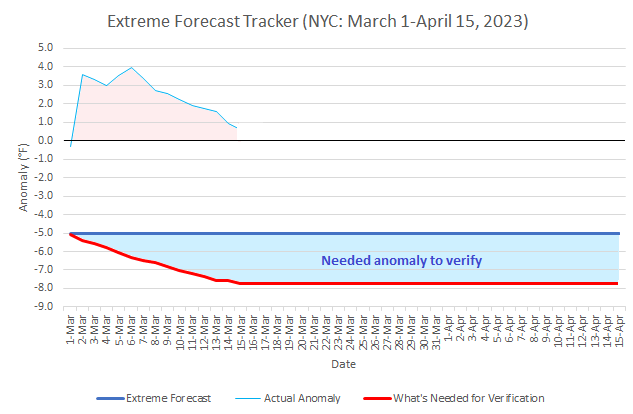
After today, no years had the combination of cold and snow required for NYC to have a March 1-April 15 temperature anomaly of 5° below normal and snowfall of 20" or above. In short, the forecast's verification now depends on an unprecedented combination of cold and snow through April 15th. Final verification vs. the extreme forecast will be made at the end of the period involved.
-
Morning thoughts… Today will be mostly sunny and milder. High temperatures will reach the middle and upper 50s in most of the region. Likely high temperatures around the region include: New York City (Central Park): 56° Newark: 58° Philadelphia: 59° Tomorrow will be another mild day. Some showers are possible. Normals: New York City: 30-Year: 49.7°; 15-Year: 50.4° Newark: 30-Year: 50.7°; 15-Year: 51.6 Philadelphia: 30-Year: 52.6°; 15-Year: 53.2°
-
I sure hope so. A weak or moderate El Niño would probably give us our best shot at a snowy outcome, as long as there is Atlantic and Pacific blocking. We'll have to watch the Atlantic SSTAs, as any marine heatwave could complicate the picture.
-
Overnight, the blustery wind will diminish. Tomorrow, much milder air will overspread the region. Temperatures will likely reach the 50s in much of the region through Saturday. Cooler air will likely return to close the weekend. No potential snowstorms appear likely through at least the next week. Instead, New York City is now on a path that could end with its setting a new low seasonal snowfall record. Historic experience with very low snowfall totals through February argues that a very snowy March or big snowstorm during March or April are unlikely. There were 16 winters that had less than 8" of snowfall through February in New York City. Just two (13%) had a 6" or greater snowstorm during March or April: 1889-1890: 6.0" on March 19th and 1991-1992: 6.2" on March 19th. With just 2.3" snowfall through March 10, New York City is at growing risk of seeing winter 2022-2023 finish with less than 10" of snow. Since 1869-70, 82% of winters with less than 8" of snow through March 10 wound up with less than 10" seasonal snowfall. All such winters wound up with less than 20" of seasonal snowfall. The ENSO Region 1+2 anomaly was +1.5°C and the Region 3.4 anomaly was -0.1°C for the week centered around March 8. For the past six weeks, the ENSO Region 1+2 anomaly has averaged +0.76°C and the ENSO Region 3.4 anomaly has averaged -0.35°C. Neutral ENSO conditions will likely prevail through at least mid-spring. The SOI was -9.57 today. The preliminary Arctic Oscillation (AO) was +0.470 today. On March 13 the MJO was in Phase 8 at an amplitude of 3.957 (RMM). The March 12-adjusted amplitude was 4.161 (RMM). Based on sensitivity analysis applied to the latest guidance, there is an implied 51% probability that New York City will have a colder than normal March (1991-2020 normal). March will likely finish with a mean temperature near 42.5° (0.3° below normal).
-
With respect to the extreme forecast that March 1-April 15 would see New York City have a temperature anomaly of 5° below normal and 20" of snow, here's where things currently stand as far as temperatures are concerned. To achieve the -5.0° anomaly, the temperature would need to average 7.7° below normal from March 16 through April 15. Just 11 years out of New York City's 154-year climate record or 7% of years saw the temperature average 7.7° below the current normal figure for that timeframe. 82% of those years occurred in the 19th century. The last such year was 1956. To achieve 20" snowfall, New York City would need 19.9" of snow during that period. Only 1956 (23.7") had sufficient snowfall. The second highest figure was 13.9" in 2018. The third highest figure was 13.6" in 1967. All said, just one year out of New York City's climate record had both the cold and snowfall necessary to verify the extreme forecast. In coming days, the City would need not just a rare outcome, but an unprecedented one for the extreme forecast to verify. As noted back in February when the extreme forecast was issued, that forecast was never likely to verify. It was detached from New York City's climate and disconnected from the evidence. At that time, none of the long-range guidance (ECWMF weeklies or CFSv2) had anything close to such an outcome. At present, the steep hill for verification has grown into a towering mountain. By the end of this week, that mountain will reach heights that puts its summit out of reach.
-
It is. Things are falling apart more and more each day. Only a March 16-April 15, 1956 outcome would produce both the snow and cold he forecasts. In coming days even that won't be enough.
-
"Proprietary methodology" says it all. As such, it is not rigorously vetted. Without such vetting, it's difficult to know if it has much validity e.g., it's any better than climatology at the timeframes involved.
-
1918-19: 3.8" 1919-20: 47.6"
-
No. 1918-19 was a strong El Niño. 1919-20 saw a weak El Niño.
-
5 winters that followed <10” winters had 30” or more snow. Two had 40” or more (1919-20 and 2002-03).
-
It’s mixed.
-
Yes, that’s correct. In included it, because I started from the beginning of NYC’s record.

