

donsutherland1
-
Posts
24,192 -
Joined
Content Type
Profiles
Blogs
Forums
American Weather
Media Demo
Store
Gallery
Everything posted by donsutherland1
-
It's possible that further cutbacks will be coming with this afternoon's package, especially for the coastal plain. The ensembles were never really on board (low agreement). The National Blend of Models was very persistent in showing low amounts. The most aggressive NBM numbers were 1.0" for Allentown and 0.6" for NYC (now 0.2" and 0.0" respectively on the 14z run). The Norlun trough was a wildcard, but they are very difficult to predict.
-
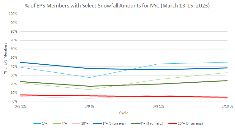
EPS ensemble members for NYC: This storm has a lot more potential and there is sufficient time for things to change significantly. At this point in time, the ensemble guidance is suggesting this could be a potentially massive snowstorm well inland (i.e., Albany, Binghamton, Concord, Scranton) and at higher elevations (Catskills, Poconos, etc.). About one-in-four ensemble members shows Boston with 10" or more. The operational ECMWF is sort of an outlier for the coastal plain in depicting around 10" for NYC. That's where the ensembles stand now. Things remain subject to significant change.
-
Latest EPS members for NYC for the upcoming system: My thinking at this time is 0.5" or less in NYC and 1"-3" 25-30 miles north and west of the City.
-
March 1997 and March 2015 also had extreme amplitudes in Phase 8.
-
A colder regime is poised to develop in coming days, even as no severe March cold appears likely. The March 13-20 timeframe could be the month's coldest week with temperatures averaging 4°- 7° below normal for the week. The colder regime will gradually fade afterward, but could persist through the closing week of March. A storm will likely bring rain to the coastal plain on Friday into Satuday. As the storm moves away on Saturday, the rain could end as a period of snow from Philadelphia to New York City. Well north and west of New York City and Newark, 1"-3" of snow could fall. Generally 0.5" or less appears likely in Philadelphia, Newark, and New York City. However, there remains a degree of uncertainty. Another larger storm could affect the region during the March 13-15 timeframe. Although this storm appears capable of bringing more snow to the region, the coastal plain again risks more rain than snow. There is a larger degree of uncertainty concerning this potential event. The picture should become clearer by the weekend. Historic experience with very low snowfall totals through February argues that a very snowy March or big snowstorm during March or April are unlikely. Despite attractive 500 mb patterns, the base case is that at least through March 10th, snowfall will likely be below normal from Philadelphia to New York City. For further historical perspective, there were 16 winters that had less than 8" of snowfall through February in New York City. Just two (13%) had a 6" or greater snowstorm during March or April: 1889-1890: 6.0" on March 19th and 1991-1992: 6.2" on March 19th. Historical perspective argues for caution when the operational models are popping big snowstorms into and out of existence like quantum particles in the extended range. The ENSO Region 1+2 anomaly was +1.1°C and the Region 3.4 anomaly was -0.2°C for the week centered around March 1. For the past six weeks, the ENSO Region 1+2 anomaly has averaged +0.48°C and the ENSO Region 3.4 anomaly has averaged -0.43°C. La Niña conditions have now given way to neutral ENSO conditions. Neutral ENSO conditions will likely prevail through at least mid-spring. The SOI was +5.93 today. The preliminary Arctic Oscillation (AO) was -1.533 today. On March 7 the MJO was in Phase 8 at an amplitude of 3.856 (RMM). The March 6-adjusted amplitude was 3.659 (RMM). Based on sensitivity analysis applied to the latest guidance, there is an implied 56% probability that New York City will have a colder than normal March (1991-2020 normal). March will likely finish with a mean temperature near 42.0° (0.8° below normal).
-
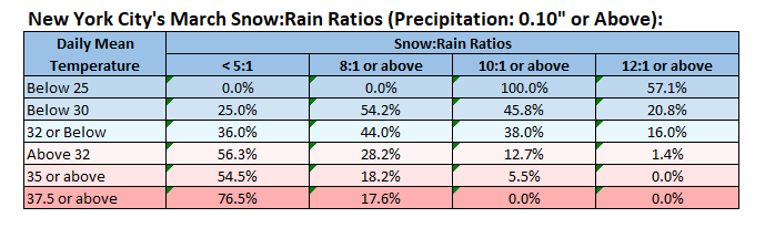
When it comes to each storm, using the soundings is far better. My point was to illustrate that in March, one should be cautious about using 10:1 maps. To illustrate my point about winters and somewhat higher ratios, for January, 10:1 or above ratios for 32° or below temperatures in NYC occurred 46% of the time and 12:1 or above ratios occurred 25% of the time. 15:1 or above ratios occurred 13.5% of the time, just slightly below the frequency of 12:1 ratios for March.
-
No. This approximation doesn’t consider conditions in the snow growth zone. Winter snow growth is usually better resulting in higher ratios.
-
Snow:Rain Ratios for New York City for March (1950-2022):
-
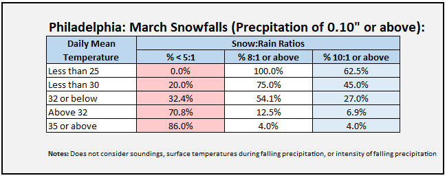
On Twitter, there has been a proliferation of 10:1 snow maps. During March, ratios tend to be lower than 10:1. As a very rough approximation, below is some data for Philadelphia's March snowfalls (precipitation of 0.10" or above) from 1950-2022 based on daily mean temperature. The kind of hourly data needed for a finer analysis is not available. Smaller precipitation amounts e.g., 0.01", can lead to skewed outcomes.
-
Morning thoughts… It will be partly sunny and pleasant. High temperatures will reach the upper 40s and lower 50s in most of the region. Likely high temperatures around the region include: New York City (Central Park): 50° Newark: 53° Philadelphia: 53° Somewhat cooler than normal to near seasonable readings will likely prevail through the remainder of the week. Normals: New York City: 30-Year: 47.5°; 15-Year: 48.1° Newark: 30-Year: 48.5°; 15-Year: 49.3 Philadelphia: 30-Year: 50.3°; 15-Year: 50.6°
-
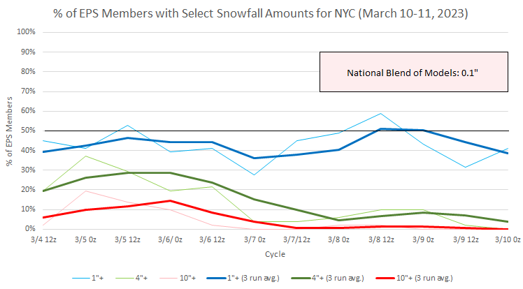
EPS members for NYC for Friday into Saturday: Ensemble support for a big snowfall in NYC, Newark, and their suburbs early next week is low on the ensembles. The 0z ECMWF is an outlier for the suburbs. For example, the ECMWF shows 11" for White Plains. However, just 3 of 51 (6%) of ensemble members show 10" or more. Even Binghamton, for which the ECMWF showed 29", had just 6 of 51 (12%) of ensemble members with 10" or more. While the storm can't be written off just yet, a lot more support will be needed to have confidence in a big snowfall idea.
-
Temperatures again rose into the upper 40s and even lower 50s across the Middle Atlantic region. In southern Florida, Miami reached 90° for the third consecutive day. With March 6-8 seeing the temperature reached 90° or above, Miami has set a new record for its earliest heatwave. The previous record of April 8-10 was set in 2020. A colder regime is poised to develop in coming days, even as no severe March cold appears likely. The March 13-20 timeframe could be the month's coldest week with temperatures averaging 4°- 7° below normal for the week. The colder regime will gradually fade afterward, but could persist through the closing week of March. A storm will likely bring rain to the coastal plain on Friday into Satuday. As the storm moves away on Saturday, the rain could end as a period of snow from Philadelphia to New York City. Well north and west of New York City and Newark, 1"-3" of snow could fall. Little or no accumulation currently appears likely in Philadelphia, Newark, and New York City. However, there remains a degree of uncertainty. Another storm could affect the region during the March 13-15 timeframe. Although this storm appears capable of bringing more snow to the region, the coastal plain again risks more rain than snow. There is a larger degree of uncertainty concerning this potential event. The picture should become clearer by the weekend. Historic experience with very low snowfall totals through February argues that a very snowy March or big snowstorm during March or April are unlikely. Despite attractive 500 mb patterns, the base case is that at least through March 10th, snowfall will likely be below normal from Philadelphia to New York City. For further historical perspective, there were 16 winters that had less than 8" of snowfall through February in New York City. Just two (13%) had a 6" or greater snowstorm during March or April: 1889-1890: 6.0" on March 19th and 1991-1992: 6.2" on March 19th. Historical perspective argues for caution when the operational models are popping big snowstorms into and out of existence like quantum particles in the extended range. The ENSO Region 1+2 anomaly was +1.1°C and the Region 3.4 anomaly was -0.2°C for the week centered around March 1. For the past six weeks, the ENSO Region 1+2 anomaly has averaged +0.48°C and the ENSO Region 3.4 anomaly has averaged -0.43°C. La Niña conditions have now given way to neutral ENSO conditions. Neutral ENSO conditions will likely prevail through at least mid-spring. The SOI was +5.31 today. The preliminary Arctic Oscillation (AO) was -2.084 today. On March 6 the MJO was in Phase 7 at an amplitude of 3.658 (RMM). The March 5-adjusted amplitude was 3.286 (RMM). Based on sensitivity analysis applied to the latest guidance, there is an implied 55% probability that New York City will have a colder than normal March (1991-2020 normal). March will likely finish with a mean temperature near 42.0° (0.8° below normal).
-
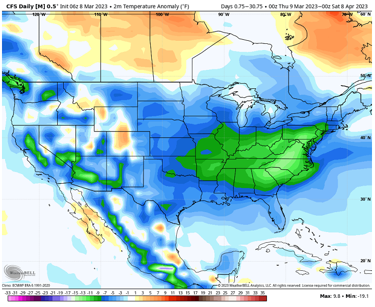
The below CFSv2 map was posted on Twitter this morning. No commentary about the nature of modeled depiction was included. Thus, it was implied that a month-long period of historic cold for the timeframe is forthcoming. The magnitude of cold shown above has virtually no chance at verifying. Minimal due diligence would have required that one check out the solution to see if it's reasonable before posting it. As an example, I will use Washington, DC and Raleigh. For Washington, DC, the posted map assumes that the March 8-April 7 period would average about 12 degrees below normal. The normal 1991-2020 figure is 49.6°. The map implies a 37.6° average temperature. Washington, DC has never seen such a cold March 8-April 7 period. It has seen just four cases with a mean temperature below 40°: 1885: 38.1° 1887: 39.9° 1896: 39.0° 1906: 39.8° The 1881-1910 normal value for that period was 45.0°. That was more than 4.5° colder than today's normal value. The coldest value over the last 100 years occurred in 1960 with a mean temperature of 41.6°, which is 4° above the implied number on the map. For Raleigh, the map is even more unrealistic. The normal 1991-2020 value is 52.8°. The map implies an anomaly of 14° below normal (38.8° mean temperature). Raleigh's coldest such period was 44.4° in 1915. That's not even remotely in the "ballpark" of the idea shown on the map. All said, the map should not have been posted. It is highly unrealistic. It serves no useful purpose. Given that many Social Media users are unfamiliar with the models, maps, and their limitations, any post of the map should have been accompanied by appropriate disclosure that the cold shown is overdone or some other notice to alert readers to the unrealistic nature of the map. Such maps, exaggerated claims, repeated calls for extremes, among other things, create a perception that meteorologists aren't very good at forecasting--they are "guessing" and little more. In fact, that perception could not be more wrong. Meteorologists are very good. The problem is that skillful forecasts and insightful discussions are drowned out by the noise of unrealistic ideas on Social Media. Perhaps, when deciding what to post, one should keep in mind the AMS's mission statement for guidance, whether one is a professional or not: The American Meteorological Society advances the atmospheric and related sciences, technologies, applications, and services for the benefit of society. Specifically, the posts should be intended for the "benefit of society." Informing society about what to expect, alerting society to emergent risks, and explaining potential impacts all benefit society. Pushing unrealistic solutions without appropriate qualifying language does not.
-
Morning thoughts… It will be partly sunny and cool. High temperatures will reach the middle and upper 40s in most of the region. Likely high temperatures around the region include: New York City (Central Park): 48° Newark: 50° Philadelphia: 49° Somewhat cooler than normal to near seasonable readings will likely prevail through the remainder of the week. Normals: New York City: 30-Year: 47.2°; 15-Year: 47.7° Newark: 30-Year: 48.3°; 15-Year: 49.0° Philadelphia: 30-Year: 50.0°; 15-Year: 50.3°
-
EPS ensembles for NYC for Friday-Saturday.
-
A colder regime will very likely commence later this week. At present, no severe March cold appears likely. However, the March 13-20 timeframe could be the month's coldest week with temperatures averaging 4°- 7° below normal for the week. The colder regime will gradually fade afterward, but could persist through the closing week of March. Potential storminess around the March 11-12 timeframe has become less impressive on the ensembles. However, a second potential system has emerged for the March 13-15 timeframe. There is the potential for at least some snowfall in New York City, Newark, and Philadelphia with either potential system. The first will likely be mostly rain for the cities. Uncertainty persists, but the picture should become clearer near or just after midweek for the earlier system and late this week or the weekend for the latter one. Historic experience with very low snowfall totals through February argues that a very snowy March or big snowstorm during March or April are unlikely. Despite attractive 500 mb patterns, the base case is that at least through March 10th, snowfall will likely be below normal from Philadelphia to New York City. For further historical perspective, there were 16 winters that had less than 8" of snowfall through February in New York City. Just two (13%) had a 6" or greater snowstorm during March or April: 1889-1890: 6.0" on March 19th and 1991-1992: 6.2" on March 19th. Historical perspective argues for caution when the operational models are popping big snowstorms into and out of existence like quantum particles in the extended range. The ENSO Region 1+2 anomaly was +1.1°C and the Region 3.4 anomaly was -0.2°C for the week centered around March 1. For the past six weeks, the ENSO Region 1+2 anomaly has averaged +0.48°C and the ENSO Region 3.4 anomaly has averaged -0.43°C. La Niña conditions have now given way to neutral ENSO conditions. Neutral ENSO conditions will likely prevail through at least mid-spring. The SOI was +7.42 today. The preliminary Arctic Oscillation (AO) was -2.487 today. On March 5 the MJO was in Phase 7 at an amplitude of 3.284 (RMM). The March 4-adjusted amplitude was 3.030 (RMM). Based on sensitivity analysis applied to the latest guidance, there is an implied 56% probability that New York City will have a colder than normal March (1991-2020 normal). March will likely finish with a mean temperature near 42.0° (0.8° below normal).
-
Newark: 7.3" for the first storm, 4.1" for the second Mount Pocono: 9.3" for the first storm, 6.8" for the second
-
That was the monthly total. The biggest storm was 6.0”.
-
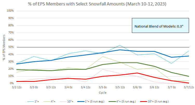
The 0z ECMWF showed a blockbuster snowfall from eastern Pennsylvania into New England (again). This time, the storm was kicked a few days into the future and was centered around March 14th. In response, 240-hour snow maps are already popping up like mushrooms after a summer thunderstorm on Social Media. Some reminders: 1. Much can change between now and then as the models work through the synoptic details. Almost certainly, there will be some significant changes. 2. Ensemble support is currently modest albeit with a few members showing a major storm (one shows a borderline historic storm). 3. Model consensus does not currently exist and run-to-run continuity has not been established. 4. Historic experience argues for extra caution. Since 1884-85, there were 19 previous winters that saw less than 10" of snow through February in New York City and Philadelphia. None saw a 10" snowstorm in either city during March. Just one saw March come out with 10" or more total snowfall in New York City. Select Data for those Winters: New York City: Mean March Snowfall: 3.5" Median March Snowfall: 2.5" Highest March Snowfall: 17.1", 1890 Philadelphia: Mean March Snowfall: 2.3" Median March Snowfall: 2.1" Highest March Snowfall: 5.8", 1890 and 1932 History is not a guarantee and the sample size is modest. It does provide some insight that asserts the importance of being cautious about jumping prematurely on extended range solutions, especially in a winter that has seen one failure after another in the snowfall department. In addition, the modeled evolution for the March 10-12 timeframe--the ECMWF's most recent try at a big snowstorm--illustrates the need for caution. For several 0z runs, the operational ECMWF had 10" or more snow in both New York City and Philadelphia (peaking at 10" in Philadelphia and 24" in New York City). Run-to-run continuity was very poor with the 12z runs shattering the dreams built from the 0z cycle. The overwhelming share of EPS members were always below 4". That potential event now appears poised to be a mostly rain event. Now, a single run of the ECMWF--again at the seemingly notorious 0z cycle--shows a massive snowstorm for both cities a few days later. Given the four points above, one should wait until there is strong support, model consensus, and good run-to-run continuity. Will this time be different? Perhaps. But a lot more data will be needed. Any firm call at this time is simple speculation in the near-absence of sufficient data. It is a largely-uninformed guess, though Twitter and other Social Media platforms have nothing that distinguishes between an informed assessment and a wild guess. In most cases, such gambles fail, as relying on near random chance to ride to the rescue of a speculative guess in the absence of underlying support is typically futile.
-
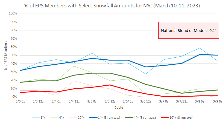
Not all snow. For the City, some mixing. The National Blend of Models, which peaked at barely over an inch now shows 0.1" for the City (for Central Park, that likely means a trace).
-
Morning thoughts… Snow will end and the clouds will yield to sunshine. High temperatures will reach the middle and upper 40s in most of the region. Likely high temperatures around the region include: New York City (Central Park): 45° Newark: 47° Philadelphia: 49° Somewhat cooler than normal to near seasonable readings will likely prevail through the remainder of the week. Normals: New York City: 30-Year: 46.9°; 15-Year: 47.4° Newark: 30-Year: 48.0°; 15-Year: 48.6° Philadelphia: 30-Year: 49.6°; 15-Year: 49.9°
-
A clipper system will bring some light rain changing to snow to parts of the region, especially from northern New Jersey southward. Snowfall amounts will 1"-2". Central Park will likely see around 0.5". Little or no accumulation is possible north of New York City. Amounts could still be somewhat higher or lower in the City given how close it will be to the heaviest precipitation. Following the clipper, it will become somewhat cooler tomorrow ahead of the development of a colder regime that will very likely commence later this week. At present, no severe March cold appears likely. However, the March 13-20 timeframe could be the month's coldest week with temperatures averaging 4°- 7° below normal for the week. The colder regime will gradually fade afterward, but could through the closing week of March. Potential storminess around the March 11-12 timeframe will need to be monitored. There is the potential for at least some snowfall in New York City, Newark, and Philadelphia. Considerable uncertainty persists, but the picture should become clearer near or just after midweek. Historic experience with very low snowfall totals through February argues that a very snowy March or big snowstorm during March or April are unlikely. Despite attractive 500 mb patterns, the base case is that at least through March 10th, snowfall will likely be below normal from Philadelphia to New York City. For further historical perspective, there were 16 winters that had less than 8" of snowfall through February in New York City. Just two (13%) had a 6" or greater snowstorm during March or April: 1889-1890: 6.0" on March 19th and 1991-1992: 6.2" on March 19th. Historical perspective argues for caution when the operational models are popping big snowstorms into and out of existence like quantum particles in the extended range. The ENSO Region 1+2 anomaly was +0.4°C and the Region 3.4 anomaly was -0.3°C for the week centered around February 22. For the past six weeks, the ENSO Region 1+2 anomaly has averaged +0.25°C and the ENSO Region 3.4 anomaly has averaged -0.50°C. La Niña conditions fading and they should evolve to neutral conditions during late winter or early spring. The SOI was +0.53 today. The preliminary Arctic Oscillation (AO) was -2.340 today. On March 4 the MJO was in Phase 7 at an amplitude of 3.111 (RMM). The March 3-adjusted amplitude was 2.219 (RMM).
-
That would be great if the needed 0.7" falls.

