donsutherland1
-
Posts
24,194 -
Joined
Content Type
Profiles
Blogs
Forums
American Weather
Media Demo
Store
Gallery
Everything posted by donsutherland1
-
Tomorrow through Thursday should be cool, but not very cold, days. Temperatures will begin to rebound on Friday with a very mild weekend following. A moderate to significant rainfall is likely Sunday into Monday. Strong southeasterly winds could impact the region as the strengthening storm passes to the north and west of the region. Overall, the first 10 days of December remain on track to finish with a solidly warmer than normal anomaly. The ENSO Region 1+2 anomaly was +2.1°C and the Region 3.4 anomaly was +2.0°C for the week centered around November 29. For the past six weeks, the ENSO Region 1+2 anomaly has averaged +2.18°C and the ENSO Region 3.4 anomaly has averaged +1.87°C. A basinwide El Niño event is ongoing. El Niño conditions will likely continue to strengthen somewhat further this month. The SOI was -6.85 on December 4. The preliminary Arctic Oscillation (AO) was -2.817 today. Strong blocking in the final week of November, as occurred this year, has often been followed by frequent blocking in December and January. On December 3 the MJO was in Phase 4 at an amplitude of 1.409 (RMM). The December 2-adjusted amplitude was 1.402 (RMM).
-
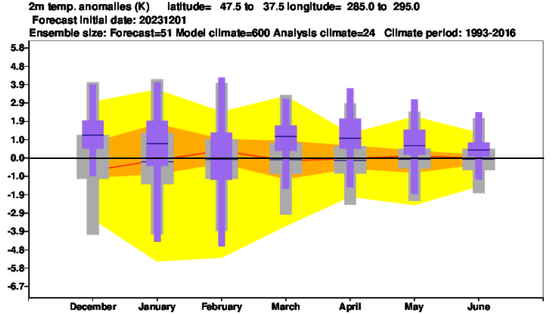
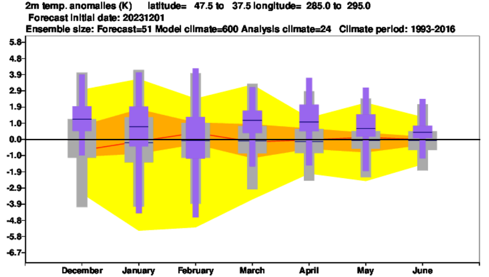
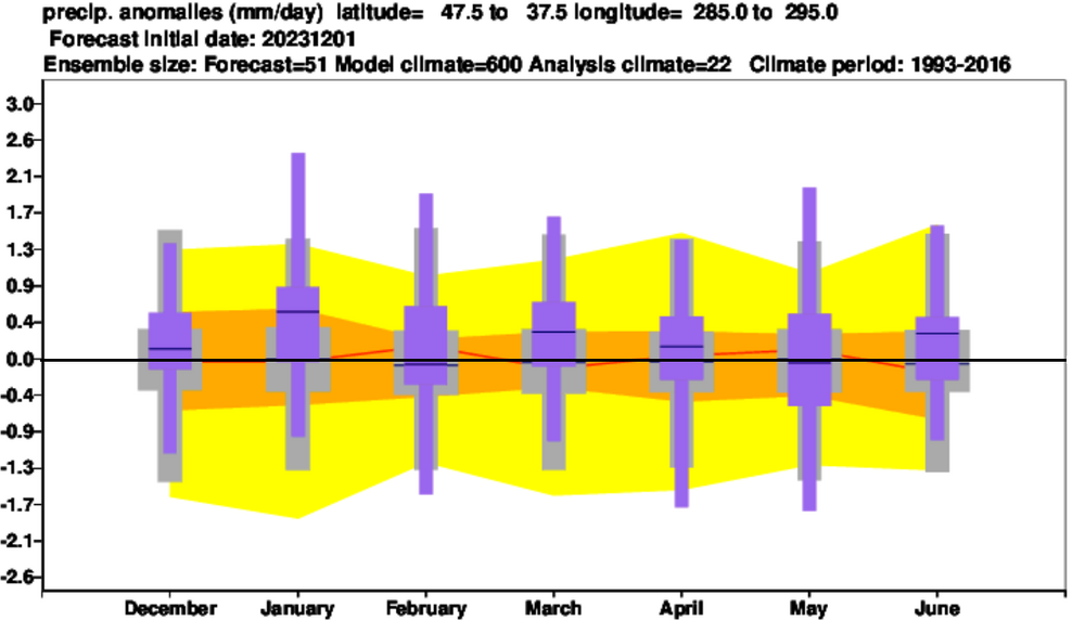
For those who are interested, below are the ECMWF monthly temperature and precipitation forecasts for the Northeast (I added the black line to demarcate the "normal" figure on the charts). The purple is the model forecast:
-
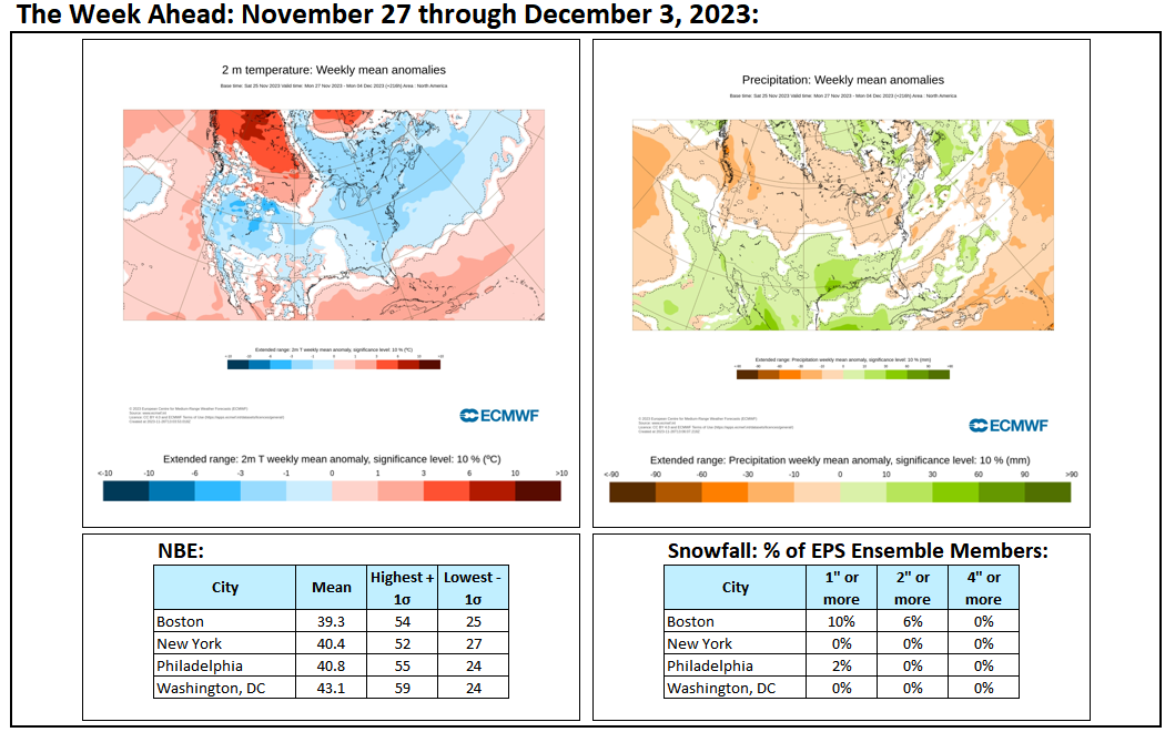
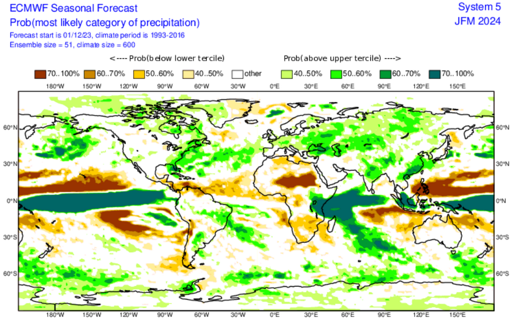
This map is also encouraging:
-
Cooler air will continue to overspread the region overnight. Most of the remainder of the week should be cooler than normal, but not very cold. Temperatures will likely rebound during the weekend. Overall, the first 10 days of December remain on track to finish with a solidly warmer than normal anomaly. A moderate to significant rainstorm is also possible during the weekend, possibly Sunday. The ENSO Region 1+2 anomaly was +2.1°C and the Region 3.4 anomaly was +2.0°C for the week centered around November 29. For the past six weeks, the ENSO Region 1+2 anomaly has averaged +2.18°C and the ENSO Region 3.4 anomaly has averaged +1.87°C. A basinwide El Niño event is ongoing. El Niño conditions will likely continue to strengthen somewhat further this month. The SOI was not available today. The preliminary Arctic Oscillation (AO) was -3.032 today. Strong blocking in the final week of November, as occurred this year, has often been followed by frequent blocking in December and January. On December 2 the MJO was in Phase 4 at an amplitude of 1.402 (RMM). The December 1-adjusted amplitude was 1.269 (RMM).
-
Although winter 2022-2023 very likely won't resemble something like 2009-10, it could feature a few shots at snowfall. If everything goes well, we might see an El Niño winter that has one really big storm as happened during the strong ENSO events during 1982-83 and 2015-16.
-
I agree. Most December and January cases following the kind of deep blocking that developed in the last week of November have seen frequent blocking. Many February cases have, too.
-
Not necessarily. If we can more or less keep the blocking, there will be some opportunities (mostly January and perhaps February). Also, those are exceptional cases. They aren't the norm.
-
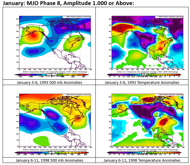
The MJO has a meaningful influence on patterns, but its impact can be muted or overwhelmed by other variables. Two examples include January 1993 and January 1998. Both months wound up much warmer than normal, despite the MJO's passing through Phases 8-1-2 for 13 days in 1993 and 10 days in 1998. Here's how those two cases fared when the MJO was in Phase 8 at a high amplitude in January.
-
While I wouldn't rule out a 2001-type outcome were the blocking to break down during the 12/18-25 period, I don't see anything that suggests a 2015-type scenario. December 2015 had no freezes (we could see one this week). December 2015 also had 11 days with lows of 50° or above and 11 days with highs of 60° or above at Central Park.
-
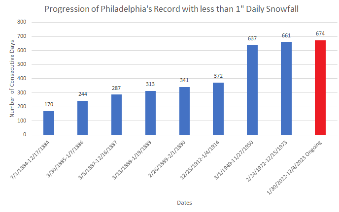
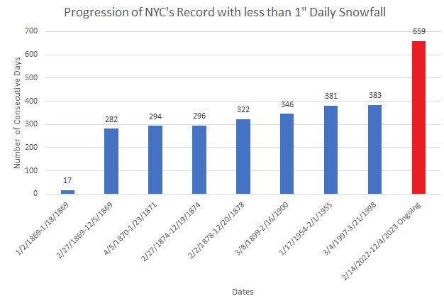
The latest MJO forecasts show a slightly longer passage through Phases 4-6 than had been shown two days earlier (Bluewave has discussed the role of sea surface temperature anomalies in foreshadowing such an outcome): The Week 3 CFSv2 (12/18-24) and ECMWF (12/18-25) are very warm in the East (>3°C/5.4°F above normal). Were blocking to break down, the possibility of one or more days in the 60s in the region (maybe even 70° in the Baltimore-Washington area) during that timeframe would increase markedly. Beyond Week 3, the ECMWF weeklies still show cooler than normal readings in the East to start January. However, skill levels beyond two weeks are low. The latest ENSO data shows that a basinwide strong El Niño event continues. The latest ENSO Region 1+2 anomaly was +2.1°C. The latest ENSO Region 3.4 anomaly was +2.0°C. The AAM is poised to go positive in coming days and then strongly positive through at least late December. A positive AAM often indicates patterns consistent with El Niño events. El Niño cases favor warm Decembers in the East, though there are exceptions. With winter largely sleeping through the medium-term, New York City's and Philadelphia's record streaks without their having seen 1" or more daily snowfall will continue for the foreseeable future. New York City's ongoing streak will very likely surpass the existing record streaks at Newark (661 days) and Trenton (664 days). Things could be worse from a winter lover's perspective. This most definitely is not December 2015 where New York City experienced a monthly mean temperature of 50.8°, decimating the record of 44.1° that had been set in 2001. Finally, Miami hit 89° yesterday, which tied its December monthly record. Miami is all but certain to record its warmest year on record. In fact, 2019, 2020, 2021, 2022, and 2023 will all rank among its 10 warmest years on record.
-
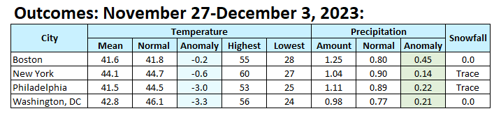
The final weekly numbers. For the most part, the region was both warmer and wetter than had been shown.

-
Despite clouds, drizzle, and periods of rain, temperatures rose into the mild 50s. Down South, Miami reached 89°. That tied the December monthly record that was set on December 13, 1900 and tied on December 3, 1902 and and December 10, 2009. Tomorrow will be another mild day before cooler, but not very cold, air arrives for most of the rest of the week. Overall, the first 10 days of December remain on track to finish with a solidly warmer than normal anomaly. The ENSO Region 1+2 anomaly was +2.0°C and the Region 3.4 anomaly was +2.1°C for the week centered around November 22. For the past six weeks, the ENSO Region 1+2 anomaly has averaged +2.22°C and the ENSO Region 3.4 anomaly has averaged +1.80°C. A basinwide El Niño event is ongoing. El Niño conditions will likely continue to strengthen into the early winter. Should the ENSO Region 1+2 and 3.4 anomalies remain at or above +1.00°C in December, which is likely, and should the PDO remain negative, there is a single past case (1950-2022) with similar ENSO/PDO conditions: December 1972. The SOI was -1.14 today. The preliminary Arctic Oscillation (AO) was -2.935 today. Strong blocking in the final week of November, as occurred this year, has often been followed by frequent blocking in December and January. On December 1 the MJO was in Phase 4 at an amplitude of 1.269 (RMM). The November 30-adjusted amplitude was 1.104 (RMM).
-
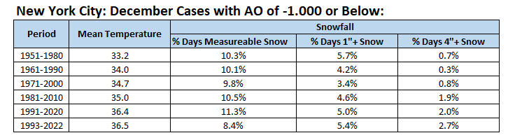
For more insight into the role of the Arctic Oscillation (AO) in December, New York City has seen a steady increase in temperature during cases where the AO was -1.000 or below. However, there is no clear trend, yet, when it comes to snowfall. The AO remains an important, but not exclusively important variable, when it comes to snowfall.
-
Some weekly numbers:

-
There is one other case where the AO was -3 or below during the last week of November and then the temperature hit 60° during the first week in December. That occurred in 2010. AO: November 25, 2010: -3.335 November 26, 2010: -4.058 November 27, 2010: -3.935 High Temperature: December 1, 2010: 60°
-
No worries. Have a great weekend.
-
For NYC (Central Park): December 1961-1990: 36.6° mean temperature December 1991-2020 (AO -1 or below): 36.4° mean temperature December 1991-2020 (AO < 0): 37.6 mean temperature
-
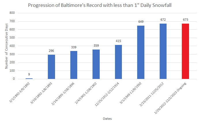
Temperatures soared into the 50s and even 60s across the region today. New York City topped out at 60° and Newark hit 61°. As a result of today's warmth, Baltimore is in the process of recording its 673rd consecutive day without an inch or more of daily snowfall. That will set a new record. New York City and Philadelphia remain mired in record streaks without an inch or more of daily snowfall. An additional round of rain will affect the region tomorrow into Monday. A general 0.25"-0.75" with some locally higher amounts is likely. Tomorrow will also be another mild day. Overall, the first 10 days of December look to be on the mild side of normal. The ENSO Region 1+2 anomaly was +2.0°C and the Region 3.4 anomaly was +2.1°C for the week centered around November 22. For the past six weeks, the ENSO Region 1+2 anomaly has averaged +2.22°C and the ENSO Region 3.4 anomaly has averaged +1.80°C. A basinwide El Niño event is ongoing. El Niño conditions will likely continue to strengthen into the early winter. Should the ENSO Region 1+2 and 3.4 anomalies remain at or above +1.00°C in December, which is likely, and should the PDO remain negative, there is a single past case (1950-2022) with similar ENSO/PDO conditions: December 1972. The SOI was +12.30 today. The preliminary Arctic Oscillation (AO) was -2.565 today. Strong blocking in the final week of November, as occurred this year, has often been followed by frequent blocking in December and January. On November 30 the MJO was in Phase 4 at an amplitude of 1.104 (RMM). The November 29-adjusted amplitude was 0.781 (RMM).
-
Today (1991-20), December days with an AO of -1 or below are as cold as all December days were during 1961-90 in NYC.
-
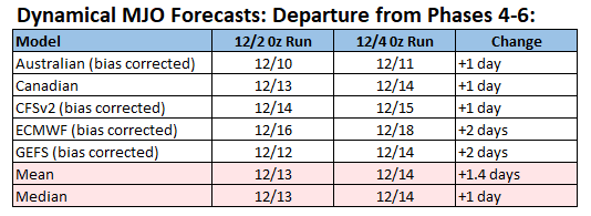
For 2023, MJO passages through Phases 4-6 have lasted an average of 10.4 days with a standard deviation of 7.8 days. A standard deviation longer stay in Phases 4-6 would imply that the MJO would move beyond Phases 4-6 by December 18th. The longest Phase 4-6 passage this year was 24 days in duration. The second and third longest were 18 and 17 days respectively. Select dynamical model forecasts for the MJO's departure from Phases 4-6: Australian (bias corrected): December 10 Canadian: December 13 CFSv2 (bias corrected): December 14 ECMWF (bias corrected): December 16 GEFS (bias corrected): December 12 It should be noted that beyond a week, MJO forecasts aren't high skill forecasts. At the same time, variables other than the MJO also impact the evolution of synoptic patterns. Atlantic blocking, which is forecast to continue through most of the next 1-2 weeks could cap the magnitude of warmth in the East during the first 2-3 weeks of December. There could still be some abnormal warmth. If the MJO exits Phases 4-6 near mid-month and if Atlantic blocking continues, one might see opportunities for more cold to start returning during the last 7 to perhaps 10 days of the month. This could mean readings begin to approach normal values (ECMWF weeklies) or perhaps somewhat below normal values (CFSv2 weeklies). Right now, there's no evidence to back some of the social media calls for late-month extreme cold in the East. Beyond mid-month, skill is very low. Given the imminent AAM+ in a basinwide strong El Niño event, a slower progression to possible cooler readings might be more likely. It should be noted that if Atlantic blocking breaks down and Pacific blocking fails to develop (the persistent PDO- could be a barrier to the development of Pacific blocking), one could see a warmer outcome. All said, the Fantasyland time range is defined by uncertainty and that degree of uncertainty should be considered. My guess at this time (for the region around NYC and Philadelphia): December 1-20: Generally warmer than normal (possible peak warmth during December 10-15?) December 21-25: Possibly turning somewhat cooler but maybe still above normal overall December 26-31: Colder air, not necessarily Arctic cold, could begin to arrive (very low confidence) Finally, I suspect that there will be frequent Atlantic blocking for December and January, as has often followed the development of strong Atlantic blocking during the last week of November. Such blocking should provide better opportunities for snowfall than had been present last winter.
-
I don’t, but others may. I would vastly prefer some snow.
-
Today will be Baltimore's 673rd consecutive day on which the City has seen less than 1" daily snowfall. That will break the record of 672 days that was set from February 23, 2011 through December 25, 2012. New York City and Philadelphia are also in the midst of record streaks.
-
Winter 2023-2024
donsutherland1 replied to Stormchaserchuck1's topic in Weather Forecasting and Discussion
Thank you, Griteater. It's encouraging to see developments that suggest that this winter will not be anything close to a repeat of the "non-winter" of 2022-23. I look forward to being able to read Cohen's blog and the upcoming NOAA blog. -
Showers could affect the region tonight into tomorrow. An additional round of showers could move into the region Sunday into Monday. Both days will be unseasonably mild. Overall, the first 10 days of December look to be on the mild side of normal. The ENSO Region 1+2 anomaly was +2.0°C and the Region 3.4 anomaly was +2.1°C for the week centered around November 22. For the past six weeks, the ENSO Region 1+2 anomaly has averaged +2.22°C and the ENSO Region 3.4 anomaly has averaged +1.80°C. A basinwide El Niño event is ongoing. El Niño conditions will likely continue to strengthen into the early winter. Should the ENSO Region 1+2 and 3.4 anomalies remain at or above +1.00°C in December, which is likely, and should the PDO remain negative, there is a single past case (1950-2022) with similar ENSO/PDO conditions: December 1972. The SOI was +7.11 today. The preliminary Arctic Oscillation (AO) was -2.840 today. Strong blocking in the final week of November, as occurred this year, has often been followed by frequent blocking in December and January. On November 29 the MJO was in Phase 3 at an amplitude of 0.781 (RMM). The November 28-adjusted amplitude was 0.457 (RMM).