donsutherland1
-
Posts
24,194 -
Joined
Content Type
Profiles
Blogs
Forums
American Weather
Media Demo
Store
Gallery
Everything posted by donsutherland1
-
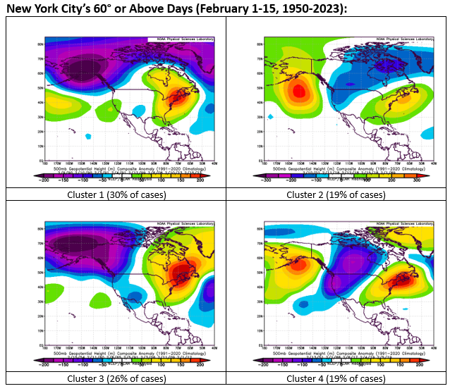
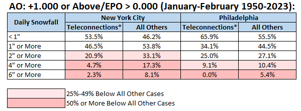
The first week of February will start unseasonably mild (40s and perhaps a few days of 50° or above in New York City). However, as some have pointed out, it won't be a "blowtorch." To get much warmer readings (60° or above) during the first half of February, the core of much above normal 500 mb height anomalies should be over the Northeastern U.S. or southern Quebec (accounts for almost 74% of such cases during February 1-15, 1950-2023). Instead, the EPS forecasts the core of the much above normal 500 height anomalies to be anchored in the vicinity of the Hudson Bay. Therefore, the most impressive warmth will likely be focused on the Great Lakes Region, Northern Plains, and central Canada. Below are clusters of outcomes that account for 25 of the 27 (93%) of 60° cases.
-
It is currently sleeting in Larchmont.
-
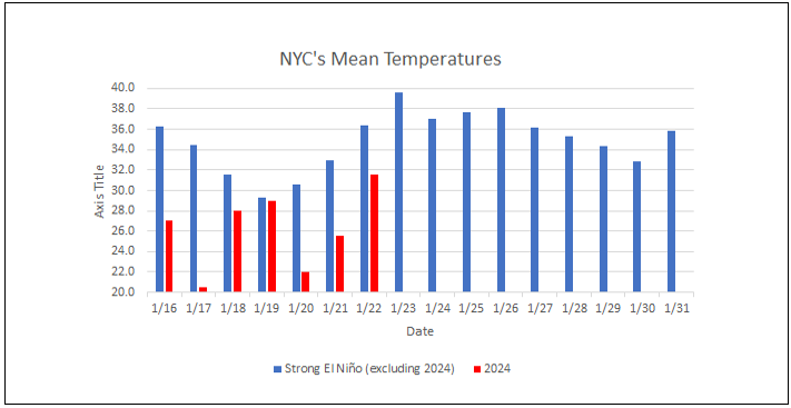
The temperature reached 40° in Central Park for the first time since January 14th when the mercury topped out at 44°. Even milder conditions lie ahead. Temperatures could peak in the middle and upper 50s in New York City and Newark and 60s from Philadelphia southward on Friday. Somewhat cooler air will arrive during the weekend. This warm period will assure that January will wind up as a warmer than normal month and Winter 2023-24 will become yet another warmer than normal winter in the New York City and Philadelphia areas. The generally mild conditions could continue into the first week of February with only brief interruptions. A storm will likely bring 0.50"-1.50" of precipitation to the region late tomorrow into Friday morning. Additional rain is possible during the weekend. The ENSO Region 1+2 anomaly was +0.8°C and the Region 3.4 anomaly was +1.7°C for the week centered around January 17. For the past six weeks, the ENSO Region 1+2 anomaly has averaged +1.10°C and the ENSO Region 3.4 anomaly has averaged +1.92°C. A basinwide El Niño event is ongoing. The ongoing El Niño event has recently peaked and will continue to fade. The SOI was -6.45 today. The preliminary Arctic Oscillation (AO) was +3.153 today. On January 21 the MJO was in Phase 5 at an amplitude of 2.816 (RMM). The January 20-adjusted amplitude was 2.838 (RMM). Based on sensitivity analysis applied to the latest guidance, there is an implied 98% probability that New York City will have a warmer than normal January (1991-2020 normal). January will likely finish with a mean temperature near 36.4° (2.7° above normal).
-
I hope you feel better soon.
-
Correct. The latest forecast for the AO’s going negative in the extended range reinforces the idea that a change to colder conditions will take place. The transition could start during the second week of the month and be complete near mid-month +/- a few days, closely matching ENSO climatology.
-
Moderate La Niña.
-
1966-67 was a neutral to somewhat negative PNA winter.
-
The Texas cold shot was more extreme relative to normal and relative to the region's records. Numerous monthly and all-time records were set during the Texas cold shot.
-
And the month-to-date anomalies:
-
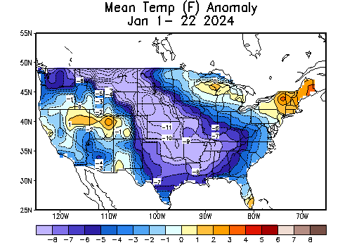
The shift was dramatic in the Plains and Great Lakes areas. January will wind up colder than normal in many places there (particularly the Plains States).
-
PNA+ for 1957-58, 1960-61, 1963-64, and 1969-70.
-
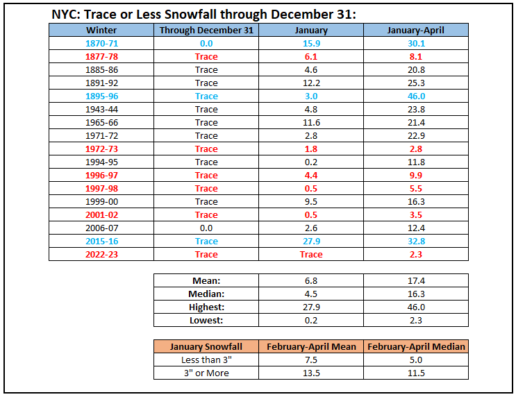
Below are some statistics for New York City's cases with total snowfall of a trace or less through December 31st:
-
Usually, there's at least one moderate (4" or above snowfall). Based on the DJF R3.4 Anomaly of +1.5 or above: 1877-78: No 6" or above storms (biggest: 5.0"); 8.1" seasonal snowfall 1888-89: No 6" or above storms (biggest: 5.5") 1957-58: Three 6" or above storms (biggest: 11.8") 1965-66: Two 6" or above storms (biggest: 6.8") 1972-73: No 6" or above storms; 2.8" seasonal snowfall. 1982-83: One 6" or above storm (17.6") 1991-92: One 6" or above storm (6.2") 1997-98: No 6" or above storms (biggest: 5.0"); 5.5" seasonal snowfall 2009-10: Three 6" or above storms (all 10" or more; biggest: 20.9") 2015-16: One 6" or above storm (record 27.5") Borderline cases just below the trimonthly threshold: 1896-97: Two 6" or above storms (biggest: 10.0") 1918-19: No 6" or above storms; seasonal snowfall: 3.8" Overall, I don't think NYC will see a snowy winter. My guess for the AmericanWx contest was 15.0" seasonal snowfall. But it's probably more likely than not that NYC hasn't seen its biggest snowfall this winter.
-
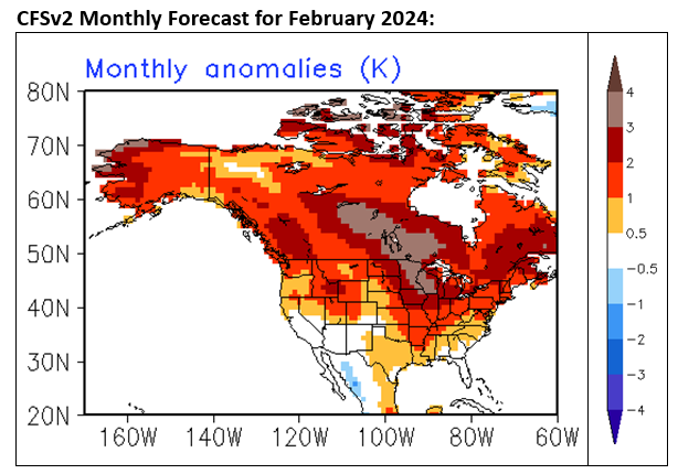
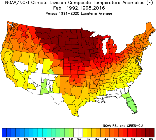
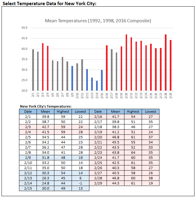
The latest CFSv2 provides what might be plausibly a "bad case" scenario for February. It essentially provides a map that is a composite of February 1992, 1998, and 2016. Even those cases saw variation in day-to-day temperatures, including several days with a composite mean temperature that was at or below 32°. Composite February 1992, 1998, and 2016 Temperature Anomalies: Composite Daily Temperature Data for New York City: February 1992, 1998, and 2016: In sum, even as February looks to get off to a mild start, which is consistent with strong El Niño climatology and also consistent with the cases implied by the latest CFSv2 monthly forecast, there should be some colder periods. Depending on the timing and track of storms, there could be at least some opportunities for snowfall. There is no guarantee that the month will be a snowy one, but the base case is that there should be some snowfall. It should be noted that monthly forecasts from this point in time on the CFSv2 do not have high skill. However, the model does show some skill at this point in time. Different outcomes remain possible. The map was used for illustrative purposes to show what a plausible bad case could look like.
-
The second lowest was actually 2.8" in 1972-73. The Southeast had a mega snowstorm during that winter.
-
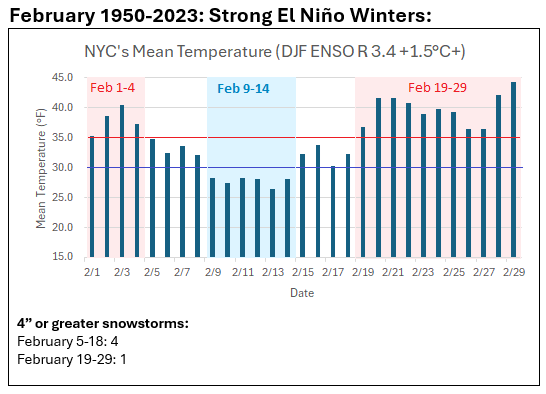
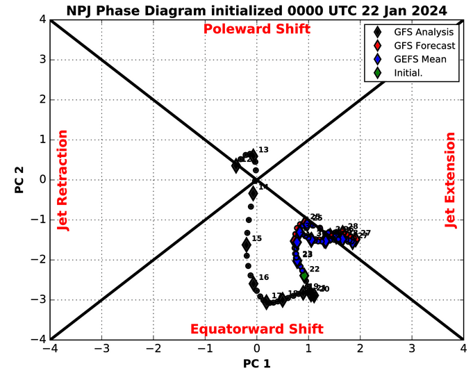
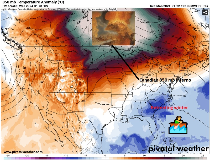
That the closing 7-10 days of January is likely to be milder than the preceding period is consistent with the evolution of strong Niño winters (DJF tri-monthly ONI of +1.5°C or above). Such winters typically see cold return for February with the coldest period being around mid-month +/- several days. There is year-to-year variability among the ENSO cases. Moreover, some of those cases had a warm February overall. The evolving period of warmer than normal temperatures, which will likely run into at least the first week of February with some brief cooler but severely cold shots, is being driven by a confluence of factors: ENSO influence (AAM is positive and likely to remain positive through the end of January) Teleconnections: The AO has gone strongly positive and the EPO is on the cusp of going positive (1/20 data) MJO: The MJO is currently in Phase 5 at a very high amplitude (2.000 or above) and will be moving through Phases 6 and into at least Phase 7 at a high amplitude (1.000 or above). Forthcoming North Pacific Jet Extension The PNA+ and Equatorward orientation of the Pacific Jet Extension will likely preclude a sustained stretch of near record or even record warmth in the New York City, Newark, and Philadelphia areas through January 31st. Nevertheless, readings will be warmer to much warmer than normal. The warmth will likely roll on into at least the first week of February. North Pacific Jet Phase Diagram: January 16-31: Past Strong El Niño Cases vs. January 2024: February Strong El Niño Cases:
-
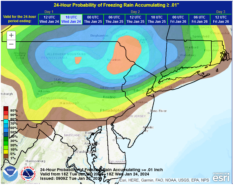
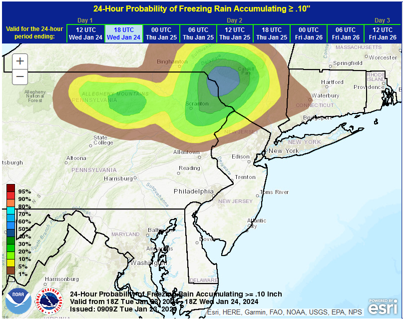
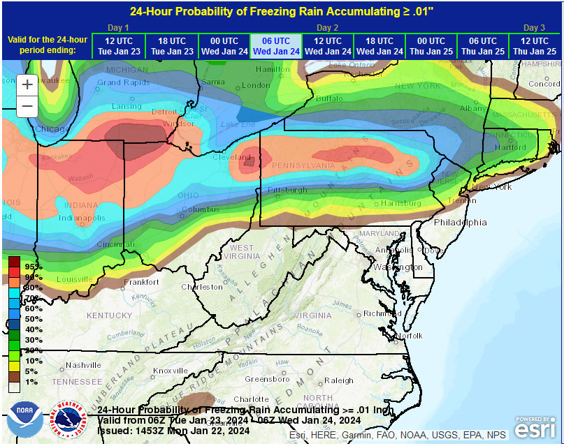
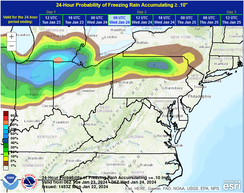
The WPC's latest ice probabilities:
-
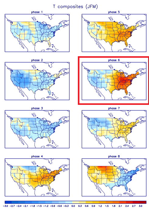
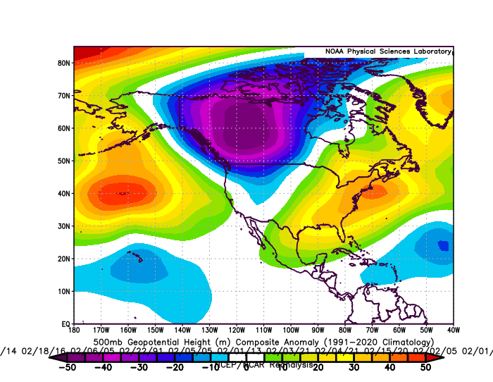
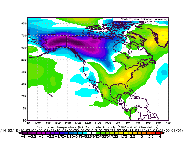
As there seems to be some confusion regarding MJO Phase 6 in February, first here are CPC's 3-month charts centered around February: Below are the 500 mb height anomalies for February 1990-2023 (Phase 6, Amplitude 1.000 or Above): Below are the surface temperature anomalies for February 1990-2023 (Phase 6, Amplitude 1.000 or Above): Sample size for the February MJO Phase 6 cases shown above was 98.
-
A milder pattern is now developing. The temperature topped out at 38° in Central Park. Even balmier readings lie ahead for later this week when the warmth crests on Friday. Temperatures could peak in the middle and upper 50s in New York City and Newark and 60s from Philadelphia southward on Friday. Somewhat cooler air will arrive during the weekend. This warm period will assure that January will wind up as a warmer than normal month and Winter 2023-24 will become yet another warmer than normal winter in the New York City and Philadelphia areas. The generally mild conditions could continue into the first week of February with only brief interruptions. A storm could bring moderate to perhaps significant precipitation to the region from Wednesday night into Friday morning. Ahead of the storm, some ice and sleet is likely far north and west of New York City and Newark, mainly from the Hudson Valley north and westward from late tomorrow into Wednesday from a weaker wave that will precede the storm. The ENSO Region 1+2 anomaly was +0.8°C and the Region 3.4 anomaly was +1.7°C for the week centered around January 17. For the past six weeks, the ENSO Region 1+2 anomaly has averaged +1.10°C and the ENSO Region 3.4 anomaly has averaged +1.92°C. A basinwide El Niño event is ongoing. The ongoing El Niño event has recently peaked and will continue to fade. The SOI was +0.85 today. The preliminary Arctic Oscillation (AO) was +2.586 today. On January 20 the MJO was in Phase 5 at an amplitude of 2.838 (RMM). The January 19-adjusted amplitude was 2.875 (RMM). Based on sensitivity analysis applied to the latest guidance, there is an implied 97% probability that New York City will have a warmer than normal January (1991-2020 normal). January will likely finish with a mean temperature near 36.4° (2.7° above normal).
-
No words needed.
-
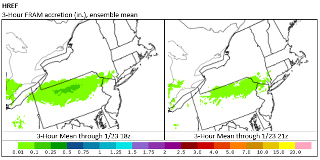
Tomorrow into early Wednesday remains on track for a light freezing rain/icing situation, generally running from northeastern Pennsylvania across the Hudson Valley into western Connecticut, but north and west of New York City and Newark. January 28-30, 2024: Possible light snow event. ☃️ Historic data for the forecast pattern, even when the timeframe is widened to include all of January and February 1950 through 2023 strongly favors a light event for both the New York City and Philadelphia areas. The 1/22 12z GFS is currently an outlier. In contrast, the 1/22 12z GGEM shows no measurable snow for either city. It is premature to rule out any snowfall, but until there is support for the periodic more aggressive outcomes, those more aggressive outcomes should be discounted. Were the EPO to be negative, the odds of something larger would increase. Were the EPO +1.000 or above, the odds of a significant snowfall would all but vanish. February 1-5, 2024: There is strong support both from the forecast teleconnections, extended range of the EPS/GEFS, and the ECMWF and CFSv2 weeklies for warmer to much warmer than normal temperatures. Therefore, this remains a high confidence idea despite the timeframe involved.
-
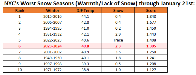
Despite last week's snowfalls and the recent cold shot, Winter 2023-24 continues to rank among the 10 worst winters in terms of warmth and lack of snowfall for New York City through January 21st.
-
That’s based on the guidance. The models shifted toward a very mild close to January. A +3 anomaly is possible, even as the guidance is short of it right now. The ECMWF weeklies are really mild.
-
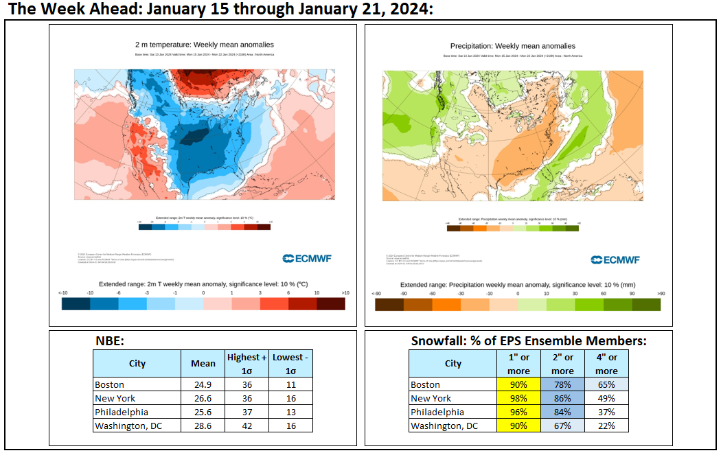
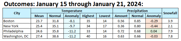
The weekly period proved colder than had been indicated on the guidance. It also saw snow in the Middle Atlantic and southern New England regions. Snowfall in Philadelphia and Washington, DC was higher than suggested by the EPS.
-
A much milder period lies ahead. The development of an EPO+/AO+ pattern will lead to a noticeable warming trend. Temperatures could peak well in the 50s in New York City and Newark and 60s from Philadelphia southward late in the week. This warm period will assure that January will wind up as a warmer than normal month and Winter 2023-24 will become yet another warmer than normal winter in the New York City and Philadelphia areas. The generally mild conditions could continue into the first week of February with only brief interruptions. A storm could bring moderate to perhaps significant precipitation to the region from Wednesday night into Friday morning. Ahead of the storm, some ice and sleet is likely far north and west of New York City and Newark, mainly from the Hudson Valley north and westward from late Tuesday through Wednesday. The ENSO Region 1+2 anomaly was +0.9°C and the Region 3.4 anomaly was +1.9°C for the week centered around January 10. For the past six weeks, the ENSO Region 1+2 anomaly has averaged +1.18°C and the ENSO Region 3.4 anomaly has averaged +1.95°C. A basinwide El Niño event is ongoing. The ongoing El Niño event has recently peaked. The SOI was +10.93 today. The preliminary Arctic Oscillation (AO) was +1.284 today. On January 19 the MJO was in Phase 5 at an amplitude of 2.875 (RMM). The January 18-adjusted amplitude was 2.993 (RMM). Based on sensitivity analysis applied to the latest guidance, there is an implied 96% probability that New York City will have a warmer than normal January (1991-2020 normal). January will likely finish with a mean temperature near 36.4° (2.7° above normal).