donsutherland1
-
Posts
24,194 -
Joined
Content Type
Profiles
Blogs
Forums
American Weather
Media Demo
Store
Gallery
Everything posted by donsutherland1
-
Washington, DC (DCA) has hit 80° for a high so far.
-
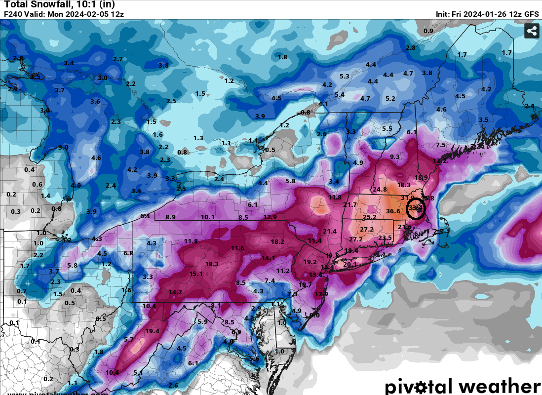
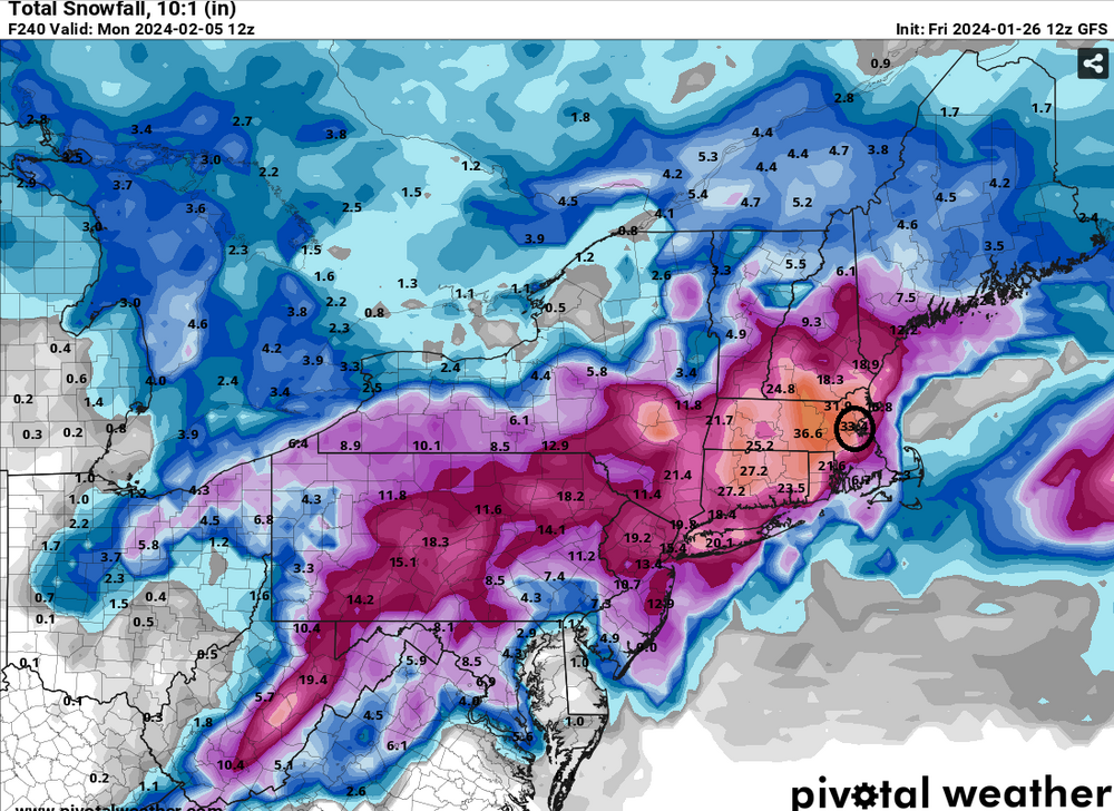
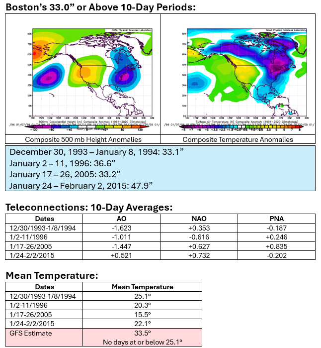
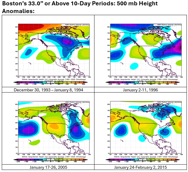
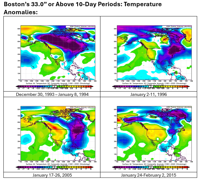
The January 26, 2024 12z run of the GFS is an outlier among the global models, both for the near-term (next 72 hours) and medium-term (240 hours). Its 10:1 maps show an extremely snowy 10-day period centered parts of New England. Boston will be used as an example to illustrate the extreme nature of the run. The 12z run shows 33.4" of snow at Boston over the 10-day period ending February 5, 2024 12z. That map is extremely unlikely to verify. There have been just four prior cases where Boston has seen 33.0" or more snowfall over a 10-day period (overlapping periods excluded). None of the highlighted periods was even close to being as mild as the one that is forecast on the 12z GFS. In sum, the 12z GFS solution through 240 hours should be disregarded: It's an outlier among global models It has no support among the ensembles It calls for the kind of snowfall that has not occurred before with such mild conditions as forecast
-
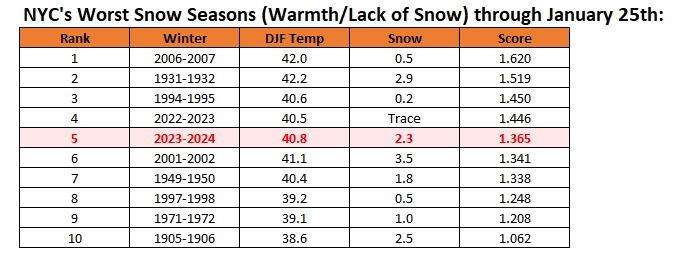
The above data is only through January 25th. The final end-of-season ranking had 1972-73 10th (mainly because it was much colder than a number of other low snowfall winters with a DJF mean temperature of 35.6°).
-
Through 11 am, NYC has had 203 hours of overcast conditions this month. Last year, January had 277 such hours through the end of the month. The most I could find was 293 hours in 2017. Data only goes back to 1996.
-
Good information. Like you, I hope next winter will wind up significantly more snowy.
-
1972-73 finished 10th on the final season ranking. It had a winter mean temperature of 35.6°, which played a key role in where it stood.
-
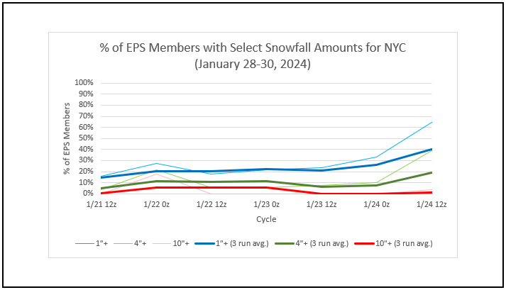
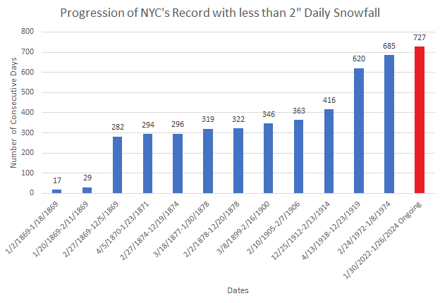
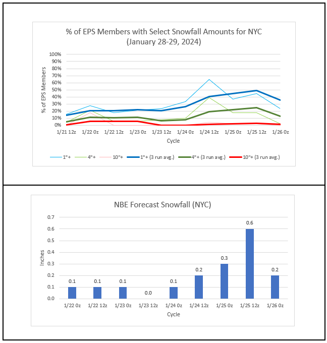
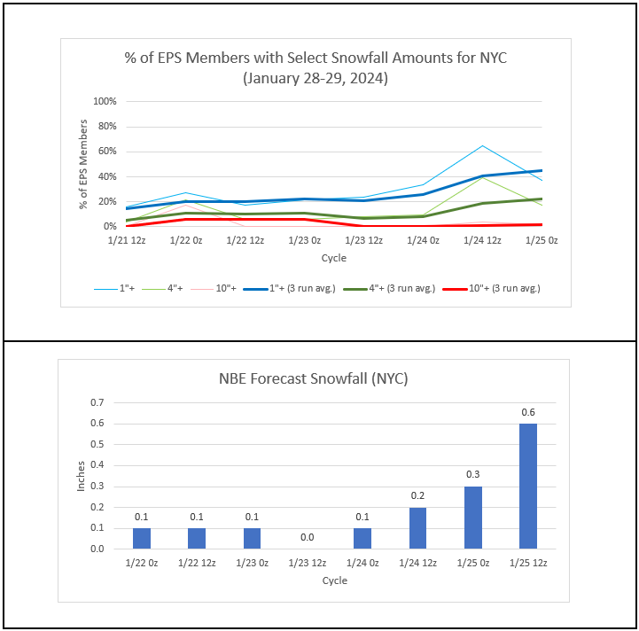
Latest EPS and NBE numbers: It should be noted that any snow in the New York City and Newark areas will very likely be very low- to low-ratio snow. Meanwhile, New York City's streak of less than 2" daily snowfall rolls on.
-
This storm is looking more and more like a late-season elevation-dependent storm. I agree with you about there possibly being big differences once at 1000-feet or above with possibly up to 8" in some of the highest elevations.
-
New York City's Winter Futility Rankings (through January 25th): The 10 worst winters prior to 2023-2024 through January 25th saw the following seasonal outcomes: Mean seasonal snowfall: 11.0" Median seasonal snowfall: 12.1" 20" or more seasonal snowfall: 20% <10" seasonal snowfall: 40% Highest seasonal snowfall: 22.9", 1971-1972 Lowest seasonal snowfall: 2.3", 2022-2023
-
The NBM is updated hourly. Here’s the list of models that are used: https://vlab.noaa.gov/web/mdl/nbm
-
I suspect the I-84 area will be hit fairly hard. Tonight’s guidance should provide some good insight (or at least I hope so).
-
Latest EPS and NBE numbers:
-
NYC (60), EWR (61), and LGA (60) have all hit 60 this month (January 13th). JFK has not.
-
Despite light rain, clouds, and fog, the temperature surged to near record and record highs today. High temperatures included: Bridgeport: 53° Islip: 57° (old record: 55°, 2010) New Haven: 59° (old record: 55°, 2010) New York City-Central Park: 59° New York City-JFK Airport: 54° (tied record set in 1972) New York City-LaGuardia Airport: 57° (tied record set in 1967) Newark: 59° (tied record set in 1972 and tied in 2010) The frontal boundary will sag southward overnight bringing slightly cooler air to the region to end the week. As a result, the mercury will likely hold in the middle and upper 40s in New York City and Newark tomorrow. Farther south, Philadelphia could see the temperature rise well into the 50s while Washington, DC basks in temperatures in the upper 60s. This warm period will assure that January will wind up as a warmer than normal month and Winter 2023-24 will become yet another warmer than normal winter in the New York City and Philadelphia areas. The generally mild conditions could continue into the first week of February with only brief interruptions. Another storm will bring additional rain to the region. The rain could end as a period of wet snow in New York City. Accumulating snow is likely well north and west of New York City and across central New England. The ENSO Region 1+2 anomaly was +0.8°C and the Region 3.4 anomaly was +1.7°C for the week centered around January 17. For the past six weeks, the ENSO Region 1+2 anomaly has averaged +1.10°C and the ENSO Region 3.4 anomaly has averaged +1.92°C. A basinwide El Niño event is ongoing. The ongoing El Niño event has recently peaked and will continue to fade. The SOI was -4.05 today. The preliminary Arctic Oscillation (AO) was +2.497 today. On January 23 the MJO was in Phase 5 at an amplitude of 2.586 (RMM). The January 22-adjusted amplitude was 2.710 (RMM). Based on sensitivity analysis applied to the latest guidance, there is an implied near 100% probability that New York City will have a warmer than normal January (1991-2020 normal). January will likely finish with a mean temperature near 36.5° (2.8° above normal).
-
Islip also set a record at 57 (old record: 55, 2010).
-
Is there any chance this winter can be graded on a curve?
-
I agree with Eric. The core of the above average 500 mb height anomalies would need to be over the Northeastern U.S. or southern Quebec to bring about such warmth.
-
Latest EPS and NBE numbers: The area of potentially appreciable with perhaps some pockets of significant snowfall will likely be north of the New York City and Newark areas. It will likely run from northwest New Jersey eastward across the Hudson Valley (northern half would do better than the southern half under the present guidance) and across central New England, including Poughkeepsie, Hartford, Worcester, and Boston.
-
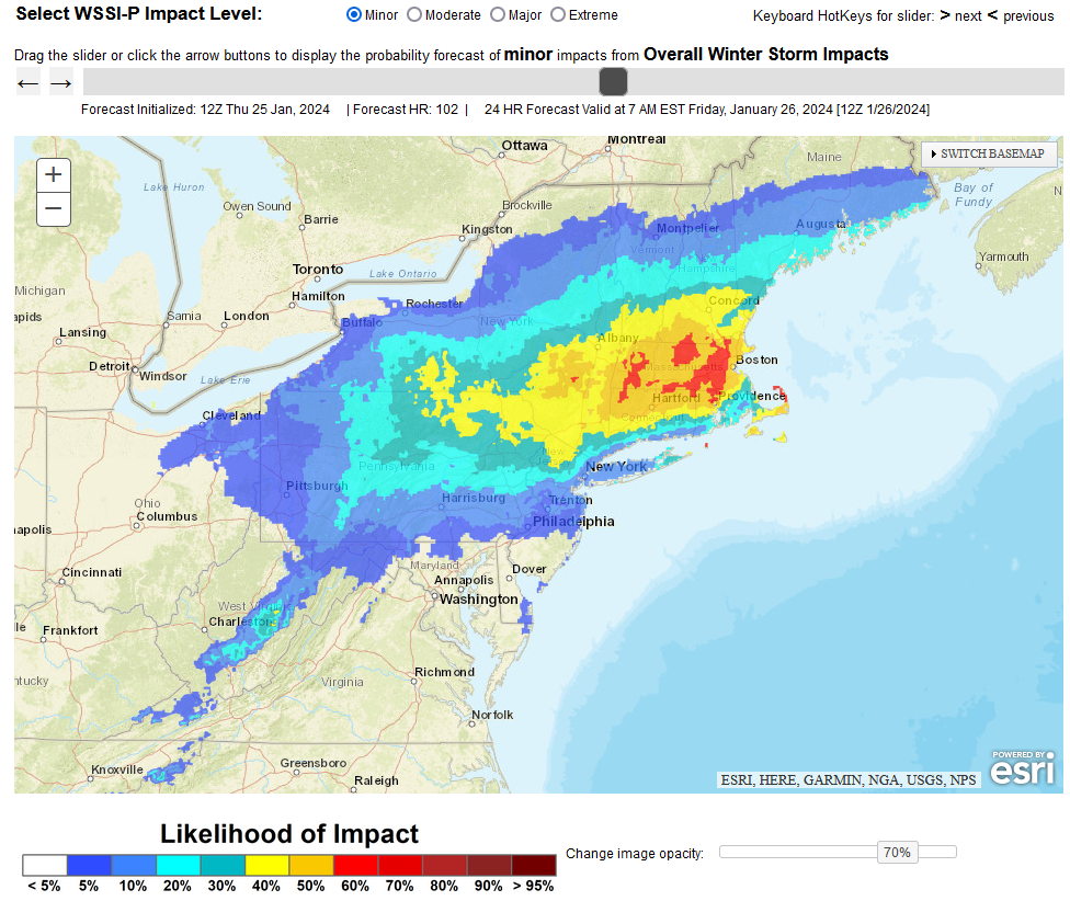
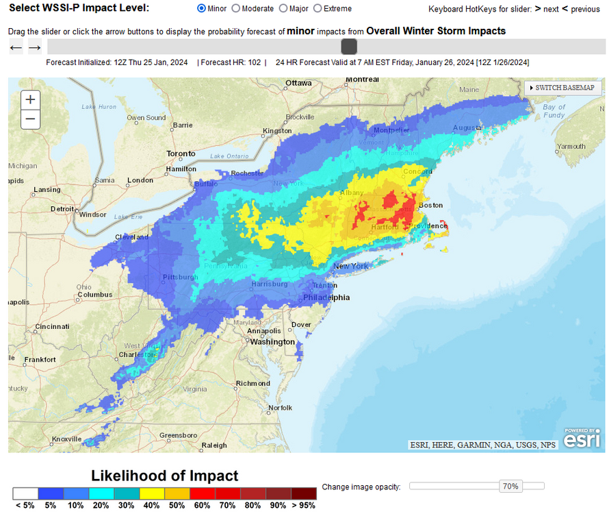
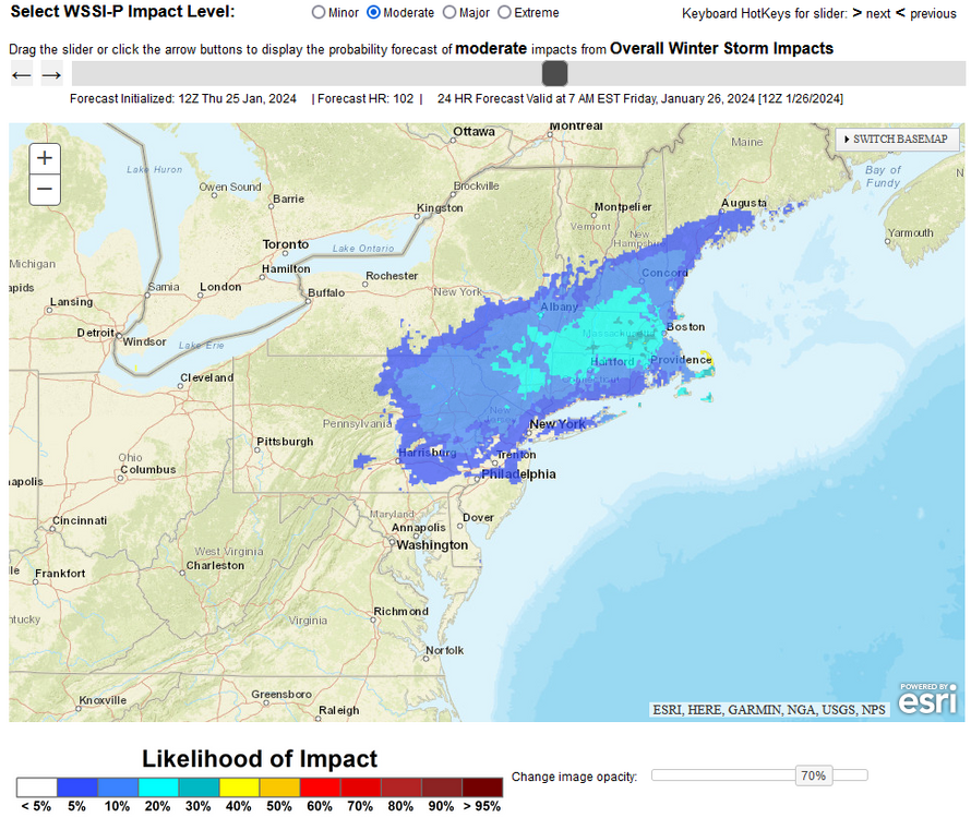
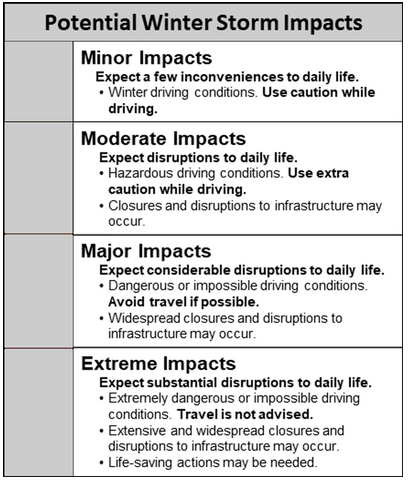
WPC Winter Storm Severity Index Maps:
-
I hope you will be getting better shortly and recover quickly.
-
Fortunately, change is on the horizon.
-
Tomorrow will be another rainy, foggy, and mild day. The temperature will top out in the lower 50s across much of the New York City area. The frontal boundary will then sag southward bringing slightly cooler air to the region to end the week. The mercury will likely hold in the upper 40s and perhaps reach 50° in New York City and Newark on Friday. Farther south, Philadelphia could see the temperature approach 60° while Washington, DC basks in temperatures in the upper 60s. This warm period will assure that January will wind up as a warmer than normal month and Winter 2023-24 will become yet another warmer than normal winter in the New York City and Philadelphia areas. The generally mild conditions could continue into the first week of February with only brief interruptions. Another storm will bring additional rain to the region. The rain could change to or end as a period of snow in New York City. Accumulating snow is likely north and west of New York City and across central New England. Some of the guidance brings accumulating snow into New York City, so the situation will have to be monitored. The ENSO Region 1+2 anomaly was +0.8°C and the Region 3.4 anomaly was +1.7°C for the week centered around January 17. For the past six weeks, the ENSO Region 1+2 anomaly has averaged +1.10°C and the ENSO Region 3.4 anomaly has averaged +1.92°C. A basinwide El Niño event is ongoing. The ongoing El Niño event has recently peaked and will continue to fade. The SOI was -4.05 today. The preliminary Arctic Oscillation (AO) was +3.599 today. That's the highest figure this winter. In addition, the EPO has now gone positive. On January 22 the MJO was in Phase 5 at an amplitude of 2.710 (RMM). The January 21-adjusted amplitude was 2.816 (RMM). Based on sensitivity analysis applied to the latest guidance, there is an implied 99% probability that New York City will have a warmer than normal January (1991-2020 normal). January will likely finish with a mean temperature near 36.4° (2.7° above normal).
-
Historical climatology, which favors areas north of NYC into New England, including Boston, noted, the Sunday-Monday storm is worth watching. While it's premature to embrace any solutions, when the two highest-scoring models (ECMWF and GGEM) reach agreement on a scenario, it bears watching.
-
Boston can sometimes score big in the kind of pattern that is forecast. The biggest example is the February 8-9, 2015 storm. Boston picked up 22.2" of snow. New York City recorded a trace. If any of the major I-95 cities (Richmond to Boston) has a reasonable chance at seeing 4" or more of snow, Boston is that city. That's not a guarantee, but the probability is far greater than for the other major I-95 cities.