donsutherland1
-
Posts
24,194 -
Joined
Content Type
Profiles
Blogs
Forums
American Weather
Media Demo
Store
Gallery
Everything posted by donsutherland1
-
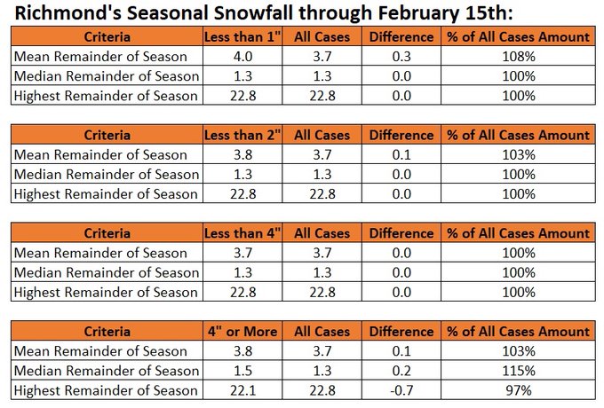
Richmond’s February 16 and later snowfall is less sensitive to bad starts than NYC’s, because snowfall opportunities are already more dispersed in its warmer climate.
-
No real changes from my earlier thinking concerning the forthcoming pattern change. The latest ECMWF weeklies, extended portion of the EPS, and CFSv2 weeklies all support the idea of a pattern change. As for the issue of single-digit readings, those remain very unlikely. Since 1950, there have been only two days with single digits during February 16-29 where the ENSO Region 3.4 anomaly was 0.5C or above and the PDO was negative. In contrast, there were 10 cases when the PDO was positive. The PDO remains negative. Considering the strongly negative preliminary January number, the PDO is very likely to have a negative average during February. Warm ENSO Region 1+2 cases also favor less severe cold. Snowfall prospects continue to favor lighter events. Historic climatology for winters with very low snowfall through February 15th argues strongly in favor of limiting expectations to lighter events with perhaps the possibility of a moderate 3"-4" event. Until the guidance consistently shows otherwise, that remains a reasonable course. The colder pattern could continue into the first week of March. Afterward, things become much more uncertain. I am aware of social media speculation comparing the upcoming change to February 2010. What that speculation misses is that Winter 2009-10 had already seen significant snowfall prior to February 20th (including in December) and was much colder over the December-January period than the current winter.
-
Week ahead numbers: A mild week with an absence of snowfall lies ahead.
-
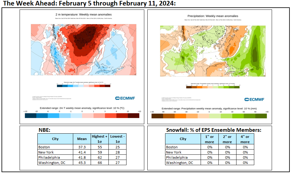
Tomorrow will be another fair and pleasant day. Temperatures will again rise to somewhat above normal levels. The dry weather will likely continue through into at least next weekend. It could turn briefly cooler early next week before much warmer air pushes into the region. The generally mild conditions will likely continue into at least the second week of February with only brief interruptions. No Arctic air is likely to reach the area during this time. As a result, the first 10 days of February could wind up 5°-7° above normal in New York City. Potentially, New York City could wind up with a mean temperature of 40.0° or above during the February 1-10 period. Since 1869, there have been 9 prior cases. Five have occurred since 2000 and eight have occurred since 1990: 1952, 1990, 1991, 1999, 2005, 2008, 2012, 2016, and 2020. Seven of those nine years saw less than 10" snowfall for the remainder of the season following February 10th. Only one saw more than 20.0" (22.7", 2005). The least was the trace of snow that fell in 2020. The mean snowfall was 7.2" while the median snowfall was 6.0". In short, this could be a reinforcing signal for a below to much below normal snowfall season. The second week of February could see the evolution toward a sustained colder pattern begin late that week. Overall, February will likely wind up warmer than normal even as the second half of the month could see a sustained period of colder weather. The ENSO Region 1+2 anomaly was +0.7°C and the Region 3.4 anomaly was +1.7°C for the week centered around January 24. For the past six weeks, the ENSO Region 1+2 anomaly has averaged +0.97°C and the ENSO Region 3.4 anomaly has averaged +1.87°C. A basinwide El Niño event is ongoing. The ongoing El Niño event will continue to fade through much of February. The SOI was -22.19 today. The preliminary Arctic Oscillation (AO) was +2.670 today. On February 1 the MJO was not available. The January 31-adjusted amplitude was 2.114 (RMM).
-
I hope MJO812 didn't just "like" this post, but is taking this matter seriously and investigating this strange phenomenon to ensure that we are all safe.
-
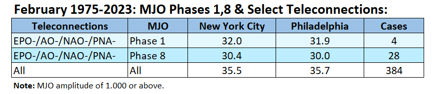
Such combinations are not common in February, especially with the MJO's being in Phase 1.
-
I will see what I can come up with tomorrow.
-
The seemingly perpetual "empire of clouds" will fall overnight as drier air overspreads the region. Sunshine, which has been a rare commodity of late, could be in abundance during the weekend. Temperatures will continue to run somewhat above normal. It could turn briefly cooler early next week before much warmer air pushes into the region. The generally mild conditions will likely continue into at least the second week of February with only brief interruptions. No Arctic air is likely to reach the area during this time. As a result, the first 10 days of February could wind up 5°-7° above normal in New York City. Potentially, New York City could wind up with a mean temperature of 40.0° or above during the February 1-10 period. Since 1869, there have been 9 prior cases. Five have occurred since 2000 and eight have occurred since 1990: 1952, 1990, 1991, 1999, 2005, 2008, 2012, 2016, and 2020. Seven of those nine years saw less than 10" snowfall for the remainder of the season following February 10th. Only one saw more than 20.0" (22.7", 2005). The least was the trace of snow that fell in 2020. The mean snowfall was 7.2" while the median snowfall was 6.0". In short, this could be a reinforcing signal for a below to much below normal snowfall season. The second week of February could see the evolution toward a sustained colder pattern begin late that week. Overall, February will likely wind up warmer than normal even as the second half of the month could see a sustained period of colder weather. The ENSO Region 1+2 anomaly was +0.7°C and the Region 3.4 anomaly was +1.7°C for the week centered around January 24. For the past six weeks, the ENSO Region 1+2 anomaly has averaged +0.97°C and the ENSO Region 3.4 anomaly has averaged +1.87°C. A basinwide El Niño event is ongoing. The ongoing El Niño event will continue to fade through much of February. The SOI was -29.40 today. The preliminary Arctic Oscillation (AO) was +3.433 today. On January 31 the MJO was in Phase 7 at an amplitude of 2.114 (RMM). The January 30-adjusted amplitude was 2.230 (RMM).
-
At least for now, the 12z GFS is an outlier. The GEFS is colder and the EPS is even more aggressive with the cold. The weeklies continue to show the cold. Moreover, the forecast EPO-/AO-/PNA+ is also consistent with a colder outlook.
-
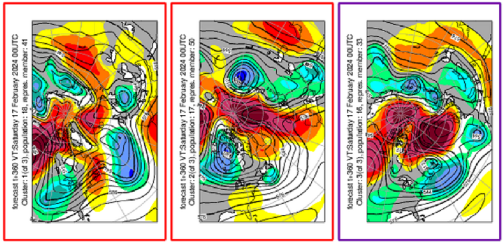
It should be noted that a national shift does not mean an Eastern U.S. shift. Here are the clusters at 360 hours: I continue to expect that a shift to colder weather will occur in the Northeast near mid-month. The 12z GFS is an outlier at the end of its range and not supported by the GEFS.
-
My attempt failed:

-
I didn't mean to suggest that NYC is somehow unique. Overall, snowfall is decreasing in many parts of the world. Some areas, though, have been witnessing rising snowfall as the benefits of added moisture outweigh the impacts of rising temperatures, which still remain sufficiently cold there for long snow seasons. Caribou provides one example. Of course, as warming continues to proceed--and the world remains on a 2.9C path (higher if Hansen is right)--many of those areas will also see a downturn in their seasonal snowfall.
-
There can be year-to-year variability. The confirmation of such a change will be seen in the 30-year seasonal snowfall averages. By the mid-2030s, if NYC is at or below 20" on the 30-year averages (which are highly correlated to 30-year winter temperatures), that will be strong evidence of that change.
-
I agree. I believe that NYC is in the early stages of a transition toward a lower snowfall regime due to the warming, not to mention pattern-related changes driven by the warming SSTs/marine heatwaves, warming Arctic, etc. The recent very low snowfall amounts could also have been amplified by an unfavorable cycle.
-
Yes, that is true. Until temperatures reach a certain threshold, the impact of big events on snowfall could outweigh the decline in snowfall from fewer smaller events. I suspect that this dynamic contributed to some extent to the snowy winters in NYC during the 2000s and early 2010s even as winters gradually warmed. It is also contributing to an ongoing increase in Caribou's snowfall. At some point, the rising warmth can't be overcome and seasonal snowfall (average) falls even as big events and big winters remain possible. Washington, DC has reached that point. Philadelphia may be near that point. I expect that NYC will reach that point in the not-too-distant future at the current rate of warming winters.
-
Latitude offers some benefits from proximity to colder air masses. It’s difficult to know whether the recent drop in snowfall is due to the early stages of a transition to a less snowy climate from background warming, a “low snow” cycle from internal variability, or both. I suspect that it is a combination and that seasonal snowfall will decline to near 20” by the mid-2030s. There will still be snowy winters. 2009-10 in Washington, DC with a warmer climate provides an example.
-
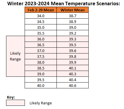
Winter 2023-2024 will likely finish at 39°F or above.
-
This forecast blocking, the consistent ECMWF weekly forecasts, cooling near the end of the forecasting range on the GEFS and EPS, and ENSO climatology all give me confidence in the onset of a cooler pattern near mid-month.
-
Biggest snowfall in NYC following a 60° or above high: February 8, 2017: 62° February 9, 2017: 9.4" of snow
-
Yes. I am encouraged that they are holding steady, if not continuing to improve.
-
Most days will be mild for the season. With the exception of 1 or 2 days, the rest of next week should see above normal temperatures. There may also be 1-2 days that see readings reach the 50s.
-
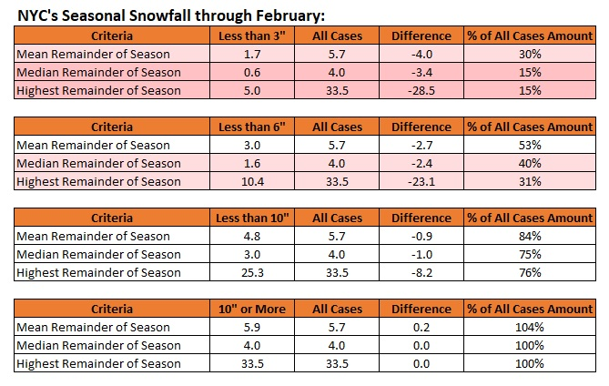
Showers and possibly a period of light rain is likely tonight. Tomorrow through the weekend should feature dry and mild readings before it turns briefly cooler early next week. The generally mild conditions will likely continue into at least the second week of February with only brief interruptions. No Arctic air is likely to reach the area during this time. The second week of February could see the evolution toward a sustained colder pattern begin late that week. Overall, February will likely wind up warmer than normal even as the second half of the month could see a sustained period of colder weather. Seasonal snowfall in New York City stood at 2.3" at the close of January. There were 19 prior winters that saw less than 3" of snow through January 31st. The mean snowfall for the remainder of the snow season for those winters was 11.4". The median snowfall was 10.4". The highest snowfall was 38.9" in 1914 with a blizzard on March 1-2 bringing 14.5" of snow. The historic figures for all winters are 14.6" and 11.8" respectively. The ENSO Region 1+2 anomaly was +0.7°C and the Region 3.4 anomaly was +1.7°C for the week centered around January 24. For the past six weeks, the ENSO Region 1+2 anomaly has averaged +0.97°C and the ENSO Region 3.4 anomaly has averaged +1.87°C. A basinwide El Niño event is ongoing. The ongoing El Niño event will continue to fade through much of February. The SOI was -29.40 today. The preliminary Arctic Oscillation (AO) was +3.529 today. On January 30 the MJO was in Phase 7 at an amplitude of 2.230 (RMM). The January 29-adjusted amplitude was 2.171 (RMM).
-
I also used statistics beyond El Niño winters to broaden the sample for some of the variables where sample sizes were very low. For single-digits, I checked for single-digit lows from 2/15 or later since 1990. Just 4/24 (17%) of cases saw one such day. Placing weight on the larger frequency of such days (<20% frequency), my guess was that such an outcome is unlikely. It's not zero, but it's sufficiently low for me to argue that it probably won't happen.
-
I'm not sure how the ECMWF arrived at 46 days.
-
Yes, that's correct. Nothing is guaranteed, but the chances of getting to normal would be remote. Things are even worse if we get to the end of February with little or no additional snowfall: