donsutherland1
-
Posts
24,194 -
Joined
Content Type
Profiles
Blogs
Forums
American Weather
Media Demo
Store
Gallery
Everything posted by donsutherland1
-
I agree. It will be interesting to see how this storm ultimately unfolds. The 24-hour map on the HREF should be impressive, but could be overdone to some extent.
-
Philly might still squeeze out an inch or two.
-
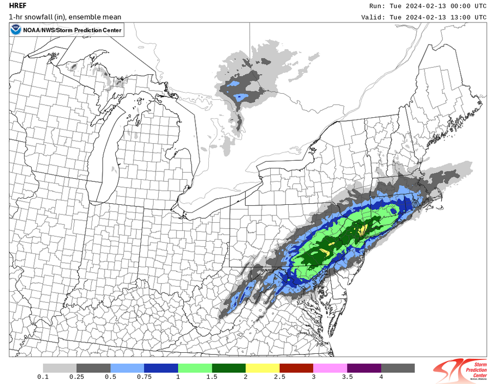
HREF at 2/13 13z:
-
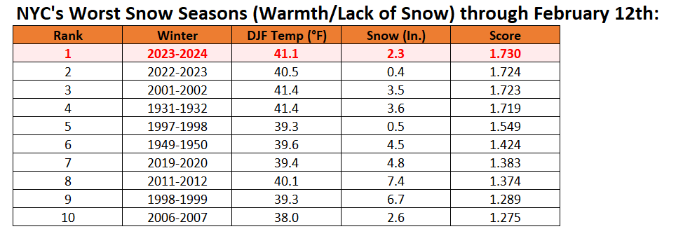
Here it is through today:
-
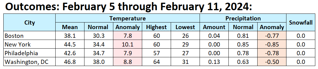
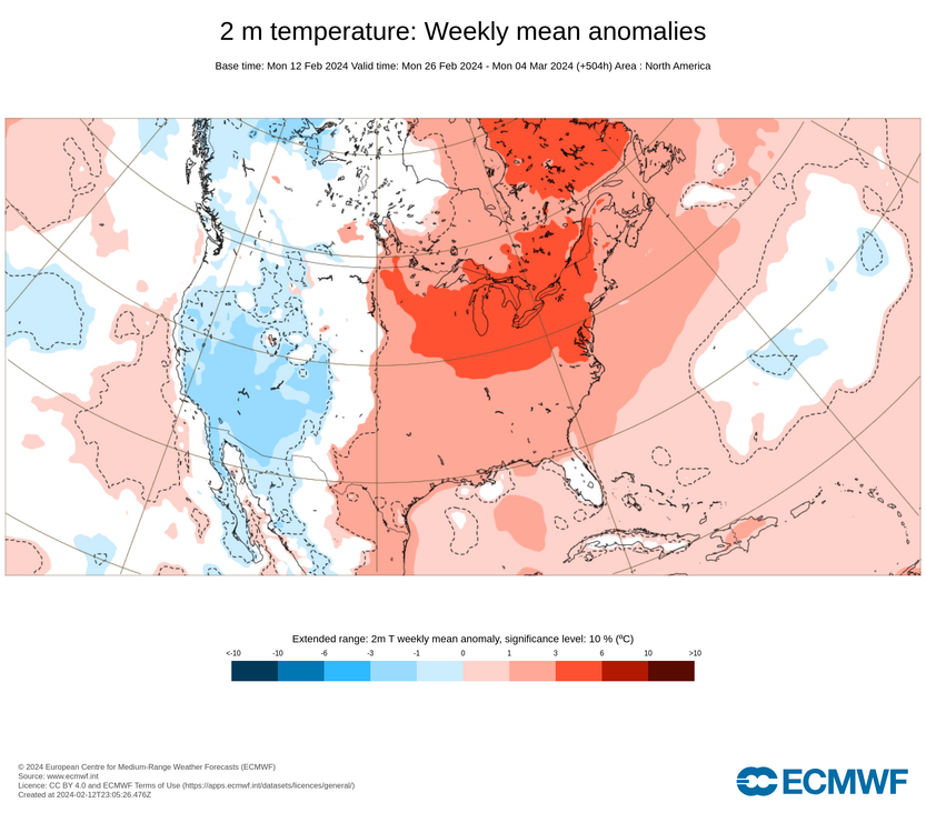
The week was exceptionally mild and very dry.

-
There has been a big change on the ECMWF weeklies for the last week of the month.
-
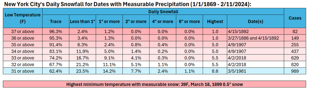
The evolution toward a sustained colder pattern will likely follow a storm that will impact the region mainly late tonight into tomorrow afternoon. This will not be an especially cold pattern, but it will be noticeably colder than the pattern that defined the first 10 days of the month. Rain will change to wet snow in Newark and New York City late tonight or early tomorrow morning. The snow could fall moderately to heavily at times. New York City, Newark, and much of Long Island could pick up 3"-6" of heavy wet snow in a December 25, 2002 rain-to-heavy wet snow scenario. 5"-10" is likely in areas just outside of New York City and Newark. Snowfall amounts could fall sharply from the northern Hudson Valley northward. It is possible that this storm could ultimately become the New York City area's biggest snowstorm of the entire winter. Temperatures will likely remain above freezing throughout most or all of the storm in New York City and adjacent areas holding down ratios and snowfall amounts. The highest daily snowfall with a low temperature of 32° or above in New York City was 5.5" that fell on April 2, 2018. Single-digit cold is unlikely in New York City following the pattern change. During February, cases with warm ENSO Region 1+2 anomalies see such lows at 55% of frequency as cold ENSO Region 1+2 cases during El Niño winters. During the second half of February, just 17% of cases with a PDO- saw single-digit cold during El Niño winters. January saw a strongly negative PDO. The ENSO Region 1+2 anomaly was +1.2°C and the Region 3.4 anomaly was +1.7°C for the week centered around February 7. For the past six weeks, the ENSO Region 1+2 anomaly has averaged +0.93°C and the ENSO Region 3.4 anomaly has averaged +1.62°C. A basinwide El Niño event is ongoing. The ongoing El Niño event will continue to fade through much of February. The SOI was -37.51 today. The preliminary Arctic Oscillation (AO) was -1.087 today. On February 10 the MJO was in Phase 7 at an amplitude of 1.957 (RMM). The February 9-adjusted amplitude was 1.671 (RMM). Based on sensitivity analysis applied to the latest guidance, there is an implied 75% probability that New York City will have a warmer than normal February (1991-2020 normal). February will likely finish with a mean temperature near 37.9° (2.0° above normal). Winter 2023-2024 is on course to finish with a seasonal mean temperature of 39.5°-40.3°. That would rank the current winter among the ten warmest on record in New York City. It would also mark the second time when two consecutive winters have ranked among the top ten in terms of warmth. Winters 2015-2016 and 2016-2017 are currently the only two such winters to rank among the ten warmest on record. Should Winter 2023-2024 finish with a mean temperature of 40.0° or above, that would be the first time on record that New York City has seen two consecutive winters with such warmth.
-
The 18z RGEM largely held serve from the 12z cycle with perhaps a tick south. Perhaps the guidance will be stabilizing in the next cycle.
-
Unfortunately, there are no model verification scores for synoptic features.
-
A quick note on the short-range ECMWF and GFS: there is statistically no difference in skill between the two models at one day or less from an event.

-
It was a mid-afternoon into evening event in NYC.
-
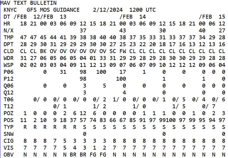
The differences among the guidance remains astonishing this close to the event. The operational GFS shows a potentially significant snowfall. Meanwhile, its MOS shows no categorical snow (trace or less). This situation illustrates just how much difficulty the guidance is having on pinning down the details for New York City. Based on the larger pool of guidance, I suspect a 3"-6" snowfall in Central Park is more likely than what the MOS is illustrating.
-
Probably non-paved surfaces.
-
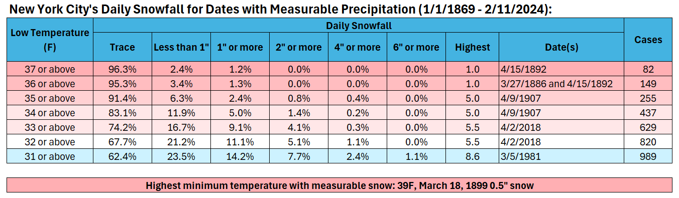
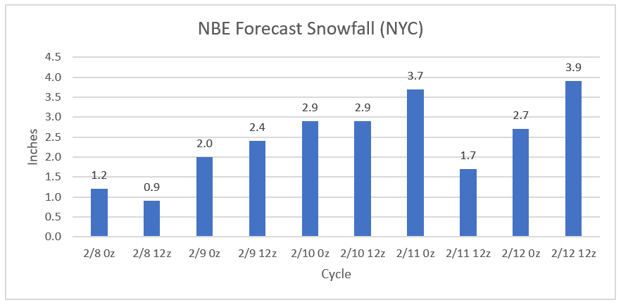
Overnight, the global and mesoscale models ramped up snowfall amounts for New York City. However, the forecast low temperature on the MOS and NBE remained at 35 or above. My assumption is that the actual temperature during the height of the storm will fall to 33 or 34 in New York City (up to 1 sigma below the 12z NBE estimate). Storm total ratios will likely be well below 10:1. At 2/12 12z, the NBE had increased its estimated snowfall for New York City to 3.9". NBE: Historic data argues against the 10" or above amounts showing up on some maps (10:1 ratios). Historic Data: Based on a combination of the guidance adjusted for ratios, assumption about temperatures, and historic data, my thinking is that New York City will see 3"-6" of heavy wet snow (1" to perhaps 3" had been my initial thinking prior to the overnight guidance). The snow will fall moderately to heavily, but there will also be a lot of melting holding down amounts. Outside the City, a general 6"-10" looks plausible.
-
Probably January 4, 2018.
-
NYC 2.8” on the 1z NBM.
-
Nice bump up on the NBE for NYC and HPN. Temperatures for NYC remain uncomfortably warm, but hopefully we'll see cooler readings modeled later on for the height of the precipitation.
-
The evolution toward a sustained colder pattern will likely follow a storm that will impact the region mainly tomorrow night into Tuesday. This will not be an especially cold pattern, but it will be noticeably colder than the pattern that defined the first 10 days of the month. Rain will likely change to wet snow in Newark and New York City tomorrow night or early Tuesday morning. The snow could fall at varying intensities. New York City and Newark could pick up 1" to perhaps 3" of slushy snow. Higher accumulations are likely north and west of the cities where the snow could fall heavily for a time in what could be a mini-version of the December 25, 2002 rain-to-heavy wet snow event. Temperatures will likely remain above freezing throughout most or all of the storm in New York City and adjacent areas holding down ratios and snowfall amounts. Single-digit cold is unlikely in New York City following the pattern change. During February, cases with warm ENSO Region 1+2 anomalies see such lows at 55% of frequency as cold ENSO Region 1+2 cases during El Niño winters. During the second half of February, just 17% of cases with a PDO- saw single-digit cold during El Niño winters. January saw a strongly negative PDO. The ENSO Region 1+2 anomaly was +1.0°C and the Region 3.4 anomaly was +1.8°C for the week centered around January 31. For the past six weeks, the ENSO Region 1+2 anomaly has averaged +0.87°C and the ENSO Region 3.4 anomaly has averaged +1.83°C. A basinwide El Niño event is ongoing. The ongoing El Niño event will continue to fade through much of February. The SOI was -40.73 today. The preliminary Arctic Oscillation (AO) was -0.945 today. On February 9 the MJO was in Phase 7 at an amplitude of 1.671 (RMM). The February 8-adjusted amplitude was 1.761 (RMM). Based on sensitivity analysis applied to the latest guidance, there is an implied 74% probability that New York City will have a warmer than normal February (1991-2020 normal). February will likely finish with a mean temperature near 37.8° (1.9° above normal). Winter 2023-2024 is on course to finish with a seasonal mean temperature of 39.5°-40.3°. That would rank the current winter among the ten warmest on record in New York City. It would also mark the second time when two consecutive winters have ranked among the top ten in terms of warmth. Winters 2015-2016 and 2016-2017 are currently the only two such winters to rank among the ten warmest on record. Should Winter 2023-2024 finish with a mean temperature of 40.0° or above, that would be the first time on record that New York City has seen two consecutive winters with such warmth.
-
White Plains has a much better chance of getting into heavy accumulating snow. Probably 3"-6".
-
It should be noted that the low temperature during the storm is 34 on the 18z HRRR. NYC has never had a 10”+ snowfall with such temperatures. The NAM briefly dips below freezing, so its solution is more defensible based on its own numbers. Until the other guidance suggests colder readings than 34-36, it’s difficult to buy these more aggressive solutions for NYC, JFK, and LGA.
-
2/11 16z NBE for NYC: 1.3” (was 1.7” at 12z).
-
I agree. Warming is just one impact of climate change. Climate change is putting a lot more energy into the system. Volatility (extremes) are growing more frequent. Wave lengths and patterns are being distorted. Even the MJO has been altered, as you noted in point 1, leading to more days in the Marine Continent and generally more warmth in parts of North America.
-
It’s a really marginal air mass. Even dynamic cooling is limited on the NBE. The RGEM might be a bit cooler. Tomorrow’s soundings will provide some good insight as they will be more reliable than today’s.
-
Measurable. My thinking for NYC is about an inch. But we'll see where things are later today.
-
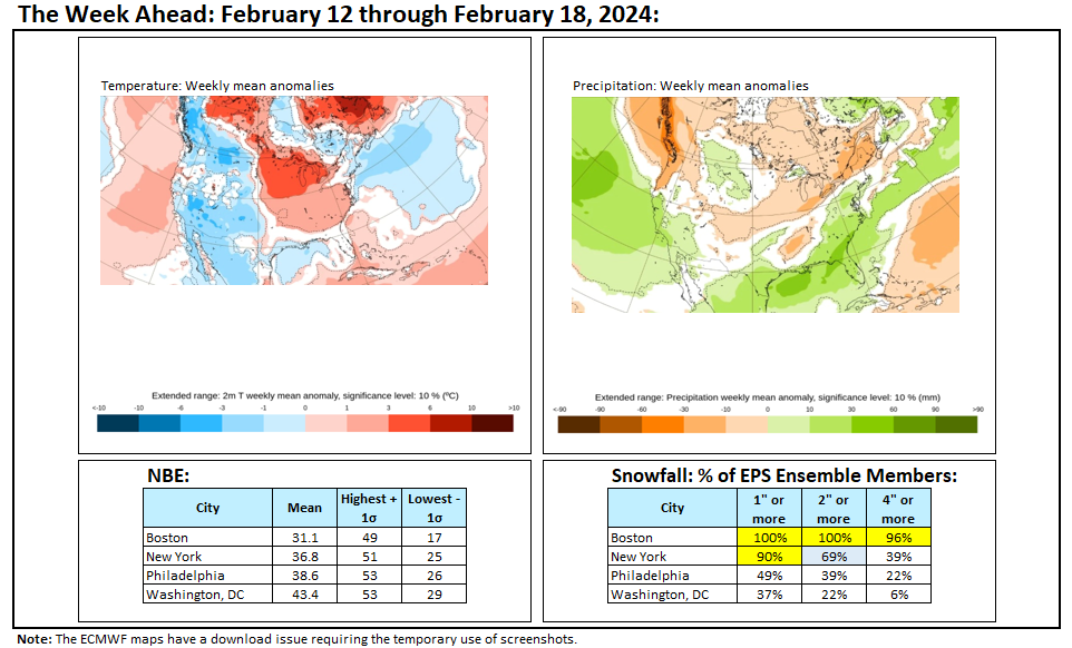
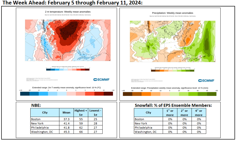
Week ahead numbers: There will be a large temperature range between Boston and New York City. Both Boston and New York City have high probabilities of seeing at least some snow. Boston could see a significant (6"+) snowfall.