donsutherland1
-
Posts
24,194 -
Joined
Content Type
Profiles
Blogs
Forums
American Weather
Media Demo
Store
Gallery
Everything posted by donsutherland1
-
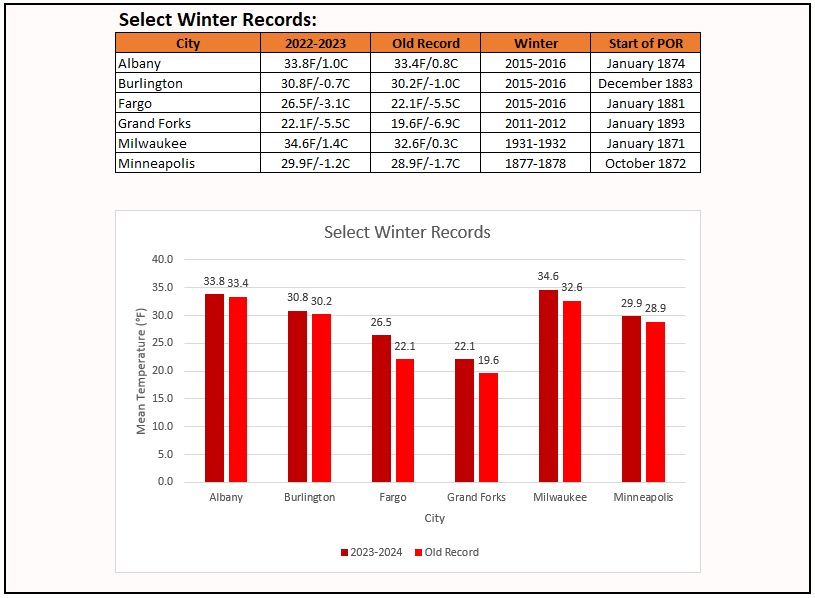
While New York City experienced its fourth warmest winter on record, numerous locations saw their warmest winter on record. Some of those locations are below:
-
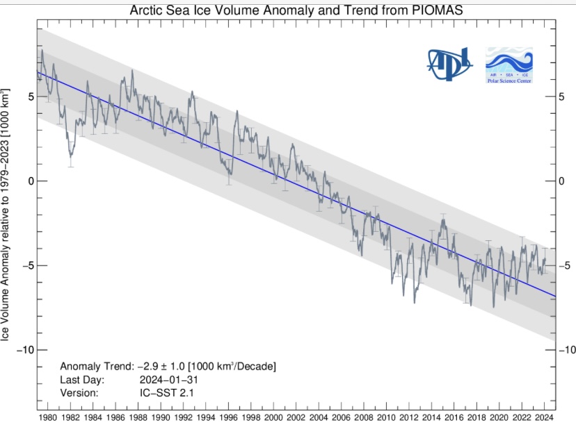
Extent is 15th. Volume is below:
-
Despite a transient cold shot to end the month, February finished with a mean temperature of 40.1° (4.2° above normal) in New York City. That tied 1954 and 2020 for the 9th warmest February on record. Winter 2023-2024 finished with a mean temperature of 40.6° in New York City. That was New York City's fourth warmest winter on record. For the first time since records began in 1869, New York City had two consecutive winters with a mean temperature of 40.0° or above. Parts of the United States concluded their warmest winter on record. Records were set in such cities as Albany, Burlington, Fargo, Milwaukee, and Minneapolis. Fargo smashed its winter record from 2015-2016 by 4.4°. Minneapolis registered 18 days during which the high temperature reached 50° or above. The old record was 8 days in Winter 1980-1981. Tonight will be another chilly but not severely cold night. The chill will disappear during the afternoon as readings soar into the 40s in New York City and possibly 50° in Philadelphia. Afterward, March will likely see generally unseasonable warmth through the first 7-10 days of the month. No significant snowfall appears likely in the northern Middle Atlantic region during that time. Overall, March will likely be warmer to much warmer than normal. The ENSO Region 1+2 anomaly was +0.7°C and the Region 3.4 anomaly was +1.5°C for the week centered around February 21. For the past six weeks, the ENSO Region 1+2 anomaly has averaged +0.92°C and the ENSO Region 3.4 anomaly has averaged +1.65°C. A basinwide El Niño event is ongoing. The ongoing El Niño event will continue to fade during March. Neutral conditions could develop during the spring. The SOI was +1.10 today. The preliminary Arctic Oscillation (AO) was +2.742 today.
-
2014-15. However, the small area of extreme cold was locked over the Northeast leading to a freezing of water bodies, including much of the Long Island Sound during a severely cold February.
-
FYI: The amount of frigid winter air is near a record low, and shrinking An analysis reveals this winter has had the second-smallest pool of cold air on record above the Northern Hemisphere, a clear sign of climate change. https://wapo.st/3Igzr59
-
NYC's coldest high this month was 36. That's the highest figure on record. The old record was 33. That record was set in 1997 and tied in 1998 and 2002. The lowest minimum temperature of 23 was the highest on record (old record: 22, 1927).
-
It’s a great site. It’s easy to use with a lot of information.
-
How often is extremeweatherwatch.com updated? There were dozens of monthly records set in North America during the last few days, including 15.7C at Ottawa yesterday.
-
Neutral ENSO winters can provide a range of extremes. Many factors are involved in shaping the winter outcomes.
-
The equipment is automated. No human measurements are needed. The trees aren't an issue during the winter. LaGuardia Airport had 40.0° or above averages for all three months.
-
January had a mean temperature of 41.4°. February had a mean temperature of 39.7°. Only 1998 (January: 40.0°; February: 40.6°) and 2023 (January: 43.5°; February: 41.1°) saw both January and February wind up with mean temperatures of 40.0° or above. No winter has seen all three months have 40.0° or above mean temperatures in New York City. Winter 2001-2002 came closest: December: 44.1°; January: 39.9°; February: 40.6°.
-
Just four: 1990, 1998, 2002, 2023
-
2011-12 had no additional snowfall. However, yesterday's late evening temperature was enough to push NYC to a 40.6° winter mean temperature (0.1° above 2011-12). As a result, Winter 2023-24 now ranks worse than 2011-12. Winter 1918-19 finished with 3.8" of snow.
-
March 2024 temperature forecast contest
donsutherland1 replied to Roger Smith's topic in Weather Forecasting and Discussion
DCA _ NYC _ BOS __ ORD _ ATL _ IAH __ DEN _ PHX _ SEA 3.5 4.8 4.5 5.5 1.8 0.9 -0.5 -2.0 0.2 -
A cold front will sweep across the region during the first half of tonight. The frontal passage will touch off some heavy showers, perhaps a thundershower, and strong winds. Afterward, the temperature will tumble through the 40s and into the 30s in New York City and 20s outside the City. Already, some large drops in temperature have occurred today. At Noon, it was 45° in Val d'Or, Quebec. The current temperature was -4°. At Noon, the temperature stood at 64° in Buffalo. The current temperature was 27°. At 5 pm, the temperature was 58° in Binghamton. The current temperature was 35°. As impressive as the arrival of the cold air will be, it will quickly depart. Temperatures will already be rebounding on the opening day of March. Afterward, March will likely see generally unseasonable warmth through the first 7-10 days of the month. No significant snowfall appears likely in the northern Middle Atlantic region during that time. Overall, March will likely be warmer than normal. The ENSO Region 1+2 anomaly was +0.7°C and the Region 3.4 anomaly was +1.5°C for the week centered around February 21. For the past six weeks, the ENSO Region 1+2 anomaly has averaged +0.92°C and the ENSO Region 3.4 anomaly has averaged +1.65°C. A basinwide El Niño event is ongoing. The ongoing El Niño event will continue to fade during March. Neutral conditions could develop during the spring. The SOI was +14.22 today. The preliminary Arctic Oscillation (AO) was +3.252 today. Based on sensitivity analysis applied to the latest guidance, there is an implied near 100% probability that New York City will have a warmer than normal February (1991-2020 normal). February will likely finish with a mean temperature near 40.0° (4.1° above normal). Winter 2023-2024 is on course to finish with a seasonal mean temperature of 40.5°. That would tie Winter 2011-2012 as the fourth warmest winter on record. It would also mark the second time when two consecutive winters have ranked among the top ten in terms of warmth. Winters 2015-2016 and 2016-2017 are currently the only two such winters to rank among the ten warmest on record. Winters 2022-2023 and 2023-2024 will become the first time on record that New York City has seen two consecutive winters with 40.0° or above mean temperatures. Since 1869, there have been six prior winters with a mean temperature of 40.0° or above. Five have occurred since 2000.
-
Unfortunately, I don’t.
-
It was a Flop... February 2024 Disco. Thread
donsutherland1 replied to Prismshine Productions's topic in New England
Burlington has reached 60° for a record-tying second time in February. Two-thirds of all 60° or above February days have occurred since 2000.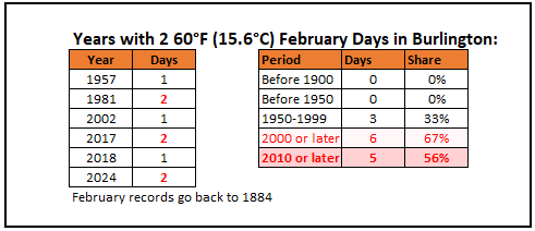
-
As of 1 pm, Ottawa has reached 13.0C (55F). That breaks the all-time February mark of 12.4C (54F) from February 27, 2000.
-
The CFSv2 has had a March 1973-esque pattern since just after the middle of February. https://www.americanwx.com/bb/topic/59981-february-2024/?do=findComment&comment=7232213 While such a pattern has not been a snowy one for parts of southern New England and the Middle Atlantic States, the Great Lakes Region has fared better with a big snowstorm just after mid-March (10.1" in Detroit during March 16-18). It will be interesting to see how the pattern evolves this time around.
-
Here's an alternative page: https://downloads.psl.noaa.gov/Public/map/teleconnections/wpo.reanalysis.t10trunc.1948-present.txt
-
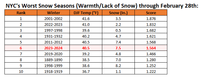
Winter 2023-2024 ranks 6th through February 28th:
-
Should NYC fail to see any additional measurable snow through March 10th, which appears likely right now, the odds would be tilted decidedly in favor of an unprecedented second consecutive season with less than 10" of snow. Winter 2023-24 will finish with a mean temperature of 40.5°. Of the 9 winters with a mean temperature of 39° or above, 7 (78%) saw less than 2.5" of snow from March 11 to the end of snow season (mean snowfall: 1.5"). Of the 13 winters with a mean temperature of 38° or above , 9 (64%) saw less than 2.5" of snow from March 11 to the end of snow season (mean snowfall: 2.4"). The subset of very warm winters (38° or above) that lacked snowfall through March 10 (less than 10") had mean snowfall of just 0.9" from March 11 to the end of snow season. Five of those six winters (83%) had less than 2.5". The lone exception was 1997-1998. The sample sizes are small highlighting the historic rarity of the kind of winter the region is experiencing.
-
Monthly high temperature records were demolished in the Great Lakes region today. Monthly record temperatures included: Detroit: 73°(old monthly record: 70°) Flint: 74° (old monthly record: 68°) Green Bay: 70° (old monthly record: 65°) Lansing: 73° (old monthly record: 69°) Madison: 70° (old monthly record: 68°) Milwaukee: 74° (old monthly record: 71°) Oshkosh: 73° (old monthly record: 67°) Rockford: 78° (old monthly record: 73°, which was set just yesterday) Saginaw: 74° (old monthly record: 67°) Wausau: 68° (old monthly record: 59°) St. Louis also set a monthly record with a high of 86°. Daily records were set in such cities as Albany (66°), Buffalo (68°), Burlington (65°), and Rochester (73°, which tied the monthly record). After a very mild day tomorrow, colder air will briefly push into the region to conclude February and start March. However, the cold won't last. Despite a cool start, March will likely see generally unseasonable warmth through the first 7-10 days of the month. No significant snowfall appears likely in the northern Middle Atlantic region during that time. Overall, March will likely be warmer than normal. The ENSO Region 1+2 anomaly was +0.7°C and the Region 3.4 anomaly was +1.5°C for the week centered around February 21. For the past six weeks, the ENSO Region 1+2 anomaly has averaged +0.92°C and the ENSO Region 3.4 anomaly has averaged +1.65°C. A basinwide El Niño event is ongoing. The ongoing El Niño event will continue to fade during March. Neutral conditions could develop during the spring. The SOI was +12.30 today. The preliminary Arctic Oscillation (AO) was +3.302 today. On February 25 the MJO was not available. The February 24-adjusted amplitude was 0.128 (RMM). Based on sensitivity analysis applied to the latest guidance, there is an implied near 100% probability that New York City will have a warmer than normal February (1991-2020 normal). February will likely finish with a mean temperature near 39.9° (4.0° above normal). Winter 2023-2024 is on course to finish with a seasonal mean temperature of 40.4°-40.6°. That would rank the current winter among the ten warmest on record in New York City. It would also mark the second time when two consecutive winters have ranked among the top ten in terms of warmth. Winters 2015-2016 and 2016-2017 are currently the only two such winters to rank among the ten warmest on record. Winters 2022-2023 and 2023-2024 will become the first time on record that New York City has seen two consecutive winters with 40.0° or above mean temperatures. Since 1869, there have been six winters with a mean temperature of 40.0° or above. Five have occurred since 2000.
-
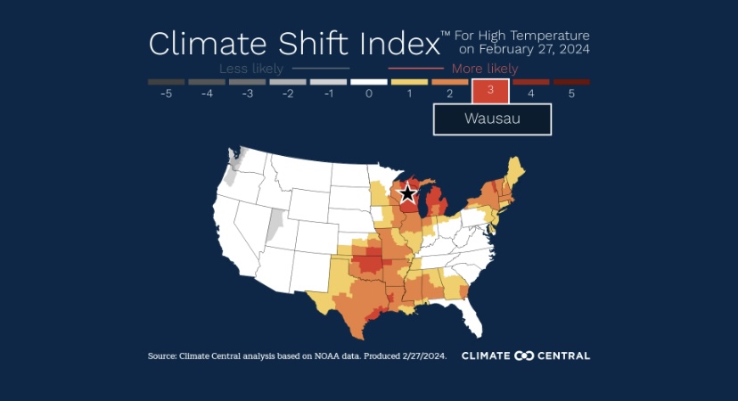
I agree. This warmth is both abnormal and unsettling. Today, Wausau’s high temperature demolished the all-time February record by 9F (5C). February records go back to 1896. That outcome was made 3 times more likely by climate change.