donsutherland1
-
Posts
24,194 -
Joined
Content Type
Profiles
Blogs
Forums
American Weather
Media Demo
Store
Gallery
Everything posted by donsutherland1
-
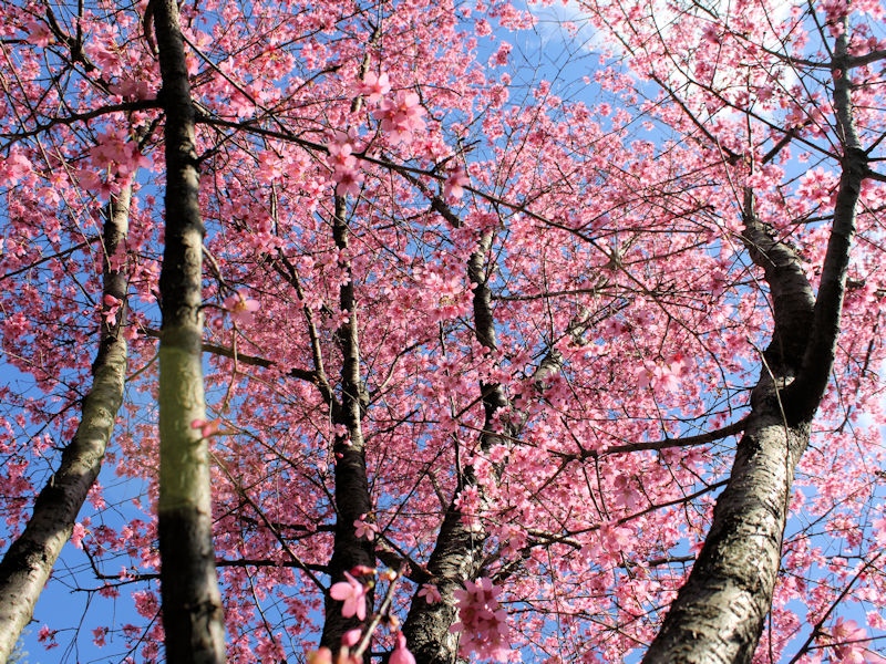
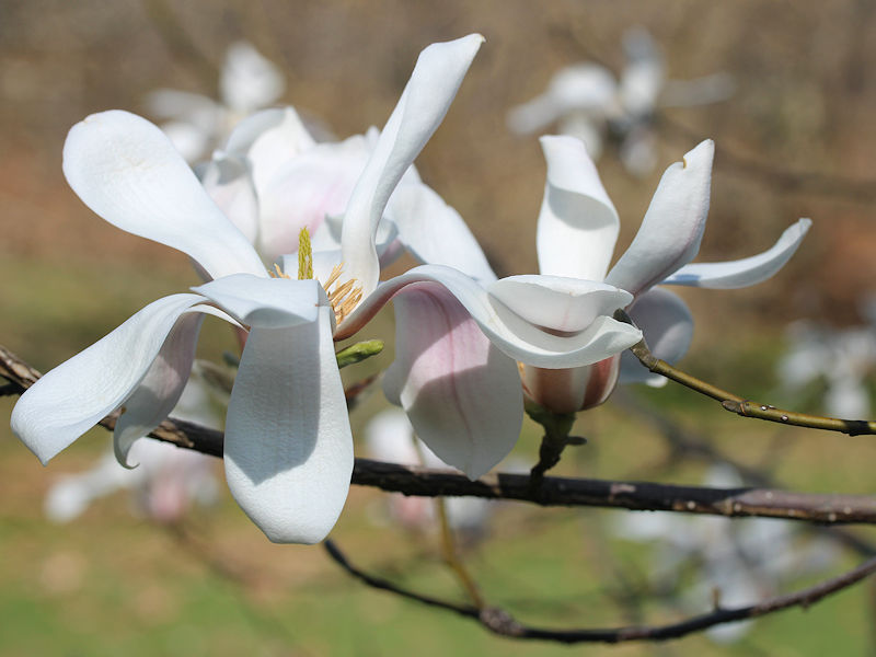
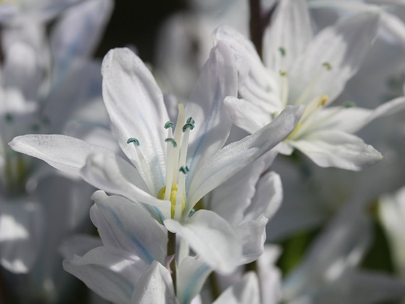
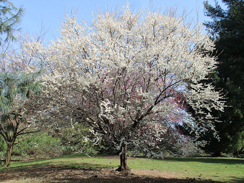
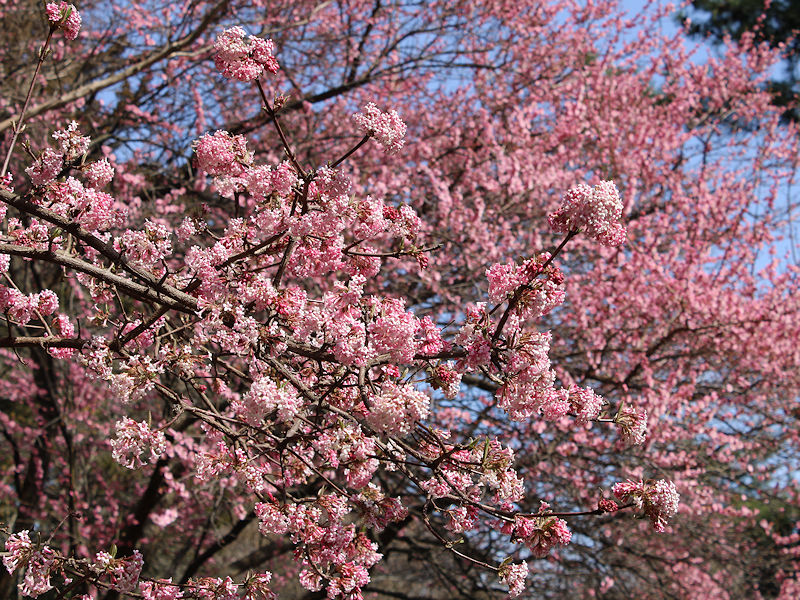
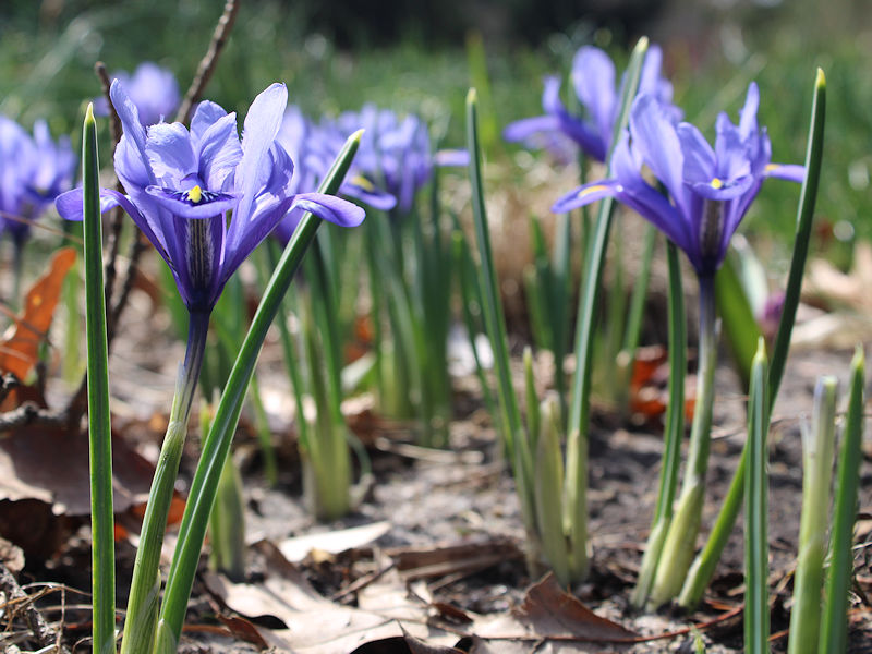
On account of the warmest first 15 days of March and the earliest 15-day period with a 50°F (10°C) or above mean temperature on record in New York City, the New York Botanical Garden has exploded into bloom. Some photos:


-
The 15-day average reached 50 during March 7-21, 1990. March 1990 saw an early shot of very cold air with the low temperature reaching 13 on March 7th. Six of the first eight days had lows of 25 or below with three days having highs in the 30s, including 33 on March 6th.
-
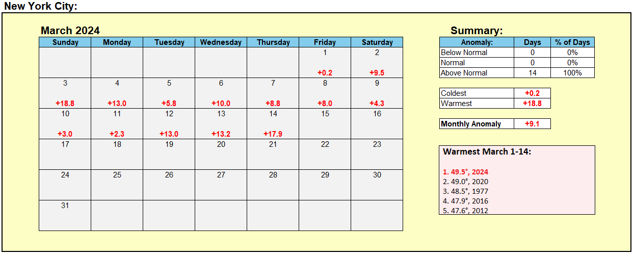
New York City saw the temperature average above 50F (10C) during March 1-15. The previous earliest 50F (10C) or above 15-day mean temperature occurred during March 3-17, 1977.
-
There was more of an easterly component to the breeze at New Haven.
-
ISP hit 73. EWR was 75 and LGA was 72.
-
Under variably cloudy skies and the lack of an onshore breeze, coastal sections saw the mercury rise to daily records. Daily record highs included: Bridgeport: 72° (old record: 65°, 1990) Islip: 73° (old record: 67°, 1990) New Haven: 65° (old record: 61°, 2022) New York City-JFK Airport: 72° (old record: 65°, 1986) Westhampton: 69° (old record: 62°, 2014) The generally mild conditions will persist through the coming weekend. However, temperatures will be somewhat cooler than on Thursday or today. Afterward, it will turn cooler with highs only in the middle and upper 40s in New York City and near 50° in Philadelphia. However, as has generally been the case this winter, no direct Arctic shots are likely. As a result, the cold will likely not be severe for the season. Moderation will occur later in the week with the temperature returning to the lower 50s. The closing days of March could turn warm. No significant snowfall appears likely in the northern Middle Atlantic region through at least March 20th. The probability of an unprecedented second consecutive winter with less than 10" seasonal snowfall in New York City's Central Park has continued to increase. It is now very likely that New York City will finish the 2023-2024 snow season with less than 10" of seasonal snowfall. Records go back to 1869. The ENSO Region 1+2 anomaly was +1.0°C and the Region 3.4 anomaly was +1.4°C for the week centered around March 6. For the past six weeks, the ENSO Region 1+2 anomaly has averaged +0.98°C and the ENSO Region 3.4 anomaly has averaged +1.53°C. A basinwide El Niño event is ongoing. The ongoing El Niño event will continue to fade during March. Neutral conditions could develop during the spring. The SOI was not available today. The preliminary Arctic Oscillation (AO) was -0.121 today. Based on sensitivity analysis applied to the latest guidance, there is an implied 96% probability that New York City will have a warmer than normal March (1991-2020 normal). March will likely finish with a mean temperature near 47.4° (4.7° above normal).
-
Newark's records go back to January 1893.
-
Newark had a temperature of -13 on December 30, 1917.
-
You did. Winter is done. A few cooler days next week can’t change things.
-
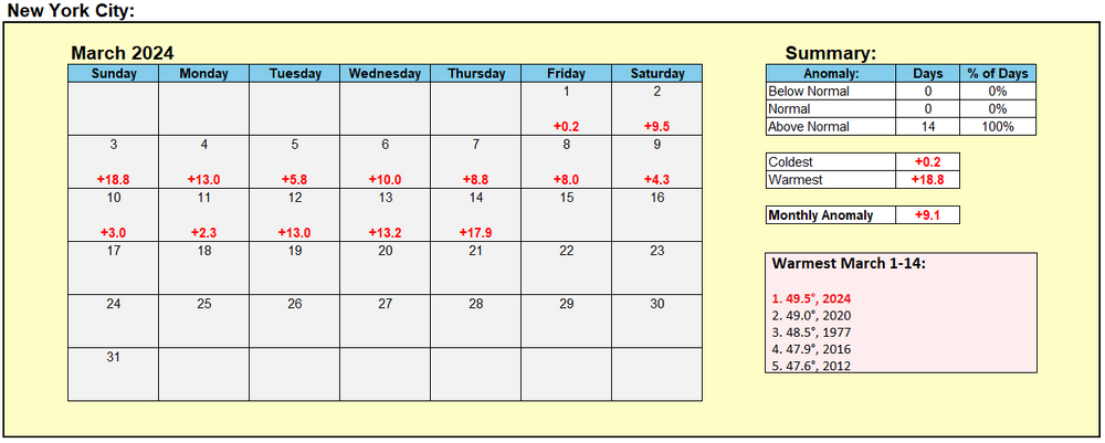
New York City's Warmest March 1-14 Period:
-
Under brilliant sunshine, the temperature soared into the 70s across much of the region. New York City topped out at 74°. The first two weeks of March had a mean temperature of 49.5° in Central Park. That broke the old record for warmest first two weeks of the month of 49.0° that was set in 2020. Five of the ten warmest first two weeks of March have occurred since 2000: 2000, 2012, 2016, 2020, and 2024. Despite some possible showers, tomorrow will be another very warm day with the temperature rising into the middle and upper 60s in the New York City area and middle and upper 70s from Philadelphia and southward. The generally mild conditions will persist through the coming weekend. Afterward, it will turn cooler. However, as has generally been the case this winter, no direct Arctic shots are likely. As a result, the cold will likely not be severe for the season. Moderation will occur later in the week. The closing days of March could turn warm. No significant snowfall appears likely in the northern Middle Atlantic region through at least March 20th. The probability of an unprecedented second consecutive winter with less than 10" seasonal snowfall in New York City's Central Park has continued to increase. Records go back to 1869. The ENSO Region 1+2 anomaly was +1.0°C and the Region 3.4 anomaly was +1.4°C for the week centered around March 6. For the past six weeks, the ENSO Region 1+2 anomaly has averaged +0.98°C and the ENSO Region 3.4 anomaly has averaged +1.53°C. A basinwide El Niño event is ongoing. The ongoing El Niño event will continue to fade during March. Neutral conditions could develop during the spring. The SOI was +18.43 today. The preliminary Arctic Oscillation (AO) was -0.502 today. Based on sensitivity analysis applied to the latest guidance, there is an implied 94% probability that New York City will have a warmer than normal March (1991-2020 normal). March will likely finish with a mean temperature near 47.1° (4.3° above normal).
-
JB's repeated high-profile forecasting failures are a sad closing chapter to his career. Almost certainly, he is aware of how badly he has been forecasting. From big snowstorms that never materialized to extreme Arctic blasts that never arrived, his Winter 2023-2024 forecasting was catastrophically bad. At this time, he should give serious and honest reflection as to where he is, how he got there, and next steps. He should keep in mind the importance of preserving his legacy and reputation, both of which are being battered his forecasting failures.
-
Congratulations on your forthcoming wedding.
-
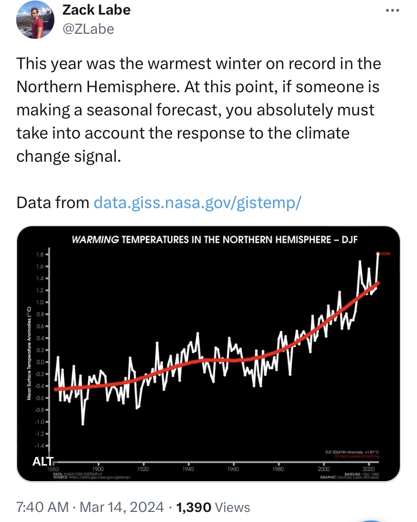
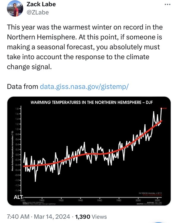
On seasonal forecasts: A shrinking cold pool renders old analogs from a colder climate increasingly less relevant. The shrinking pool of cold air has been documented in the literature. https://journals.ametsoc.org/view/journals/clim/28/9/jcli-d-14-00496.1.xml Climate change needs to be considered in seasonal forecasting. Otherwise, one will wind up with a cold bias in an increasingly warm world. https://x.com/ZLabe/status/1768240905331372274?s=20
-
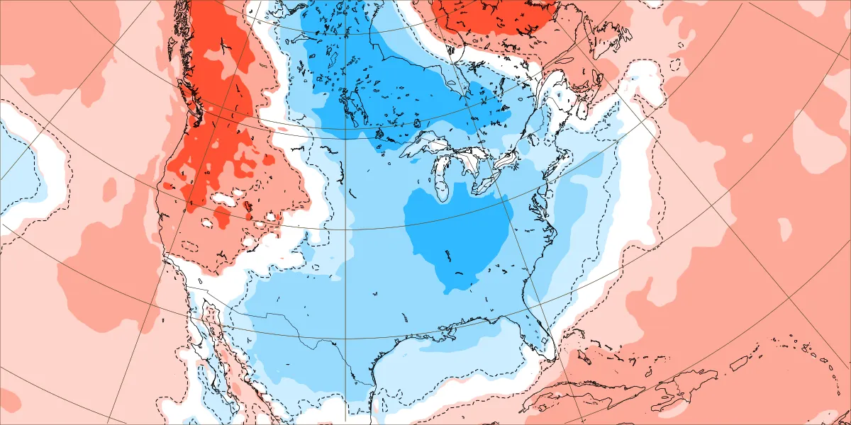
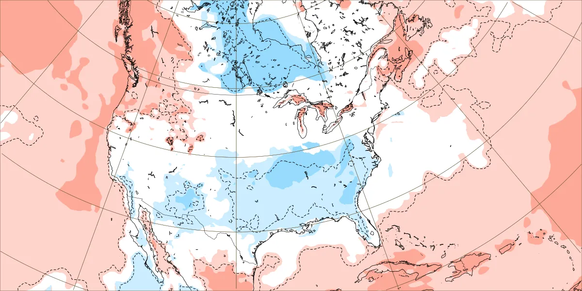
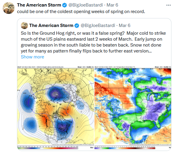
Sleight of hand: From this: To this: Notice the change in region being emphasized (from eastern North America to worldwide). The latest ensemble guidance shows nothing close to among the "coldest opening weeks of spring on record." Back in December, when it became clear that a forecast for a frigid December would not verify, the analogs were shifted (colder ones dropped and others added) to suggest that the forecast had been for a warm December in the East. In fact, the analogs had been posted on the Weatherbell final winter forecast, so one could find the change that had been made to try to evade a big forecast error.
-
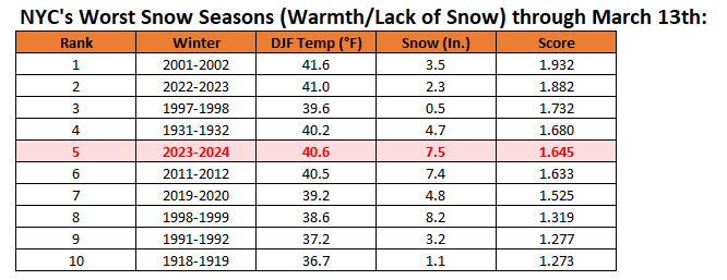
New York City's worst snow seasons (warmth and lack of snowfall) through March 13th:
-
With the continuing warmth, more and more blossoms are overspreading the New York Botanical Garden.
-
A light sea breeze held readings in the lower 60s in New York City and 50s across parts of Long Island. Meanwhile the mercury rose into the 70s in Philadelphia to Washington, DC. The warmth will peak tomorrow through Friday with the temperature rising into the middle and upper 60s in the New York City area and middle and perhaps upper 70s from Philadelphia and southward. The generally mild conditions will persist through mid-month. There is good consensus on the guidance that a deep trough will likely develop just after mid-month. However, as has generally been the case this winter, no direct Arctic shots are likely. As a result, any cold will likely not be severe for the season and the potential exists for the cooler period to last one to perhaps two weeks, much as occurred in February. Any sharper cold shots will likely have a short duration. The closing days of the month could turn warmer. No significant snowfall appears likely in the northern Middle Atlantic region through at least March 20th. The probability of an unprecedented second consecutive winter with less than 10" seasonal snowfall in New York City's Central Park has continued to increase. Records go back to 1869. The ENSO Region 1+2 anomaly was +1.0°C and the Region 3.4 anomaly was +1.4°C for the week centered around March 6. For the past six weeks, the ENSO Region 1+2 anomaly has averaged +0.98°C and the ENSO Region 3.4 anomaly has averaged +1.53°C. A basinwide El Niño event is ongoing. The ongoing El Niño event will continue to fade during March. Neutral conditions could develop during the spring. The SOI was +4.26 today. The preliminary Arctic Oscillation (AO) was -1.048 today. Based on sensitivity analysis applied to the latest guidance, there is an implied 93% probability that New York City will have a warmer than normal March (1991-2020 normal). March will likely finish with a mean temperature near 46.8° (4.0° above normal).
-
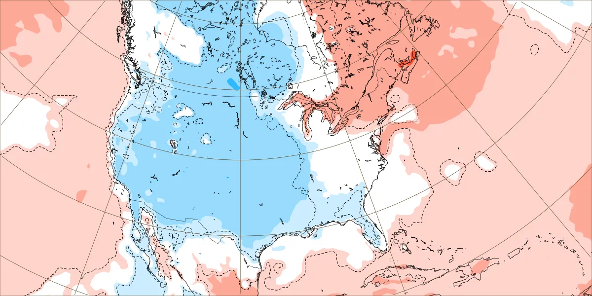
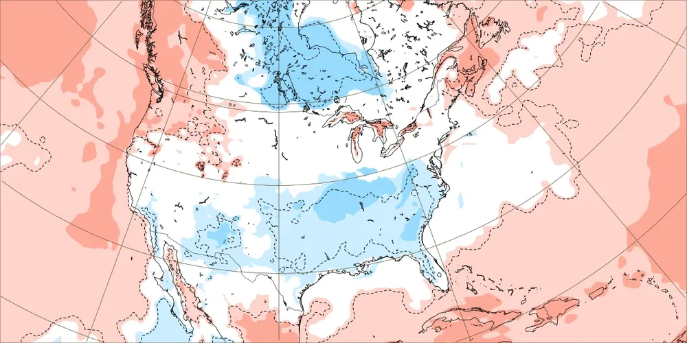
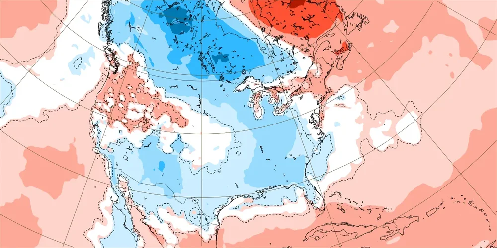
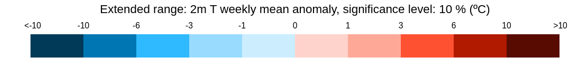
What a difference three days makes. ECMWF Weekly Forecasts from March 10th: 3/18-25: 3/25-4/1: From March 13th: 3/18-25: 3/25-4/1: Scale:


-
This development is disappointing. I'm not sure why the MEI can't be reconstructed using the JRA-3Q dataset (the successor of the discontinued JRA-55). Of course, if the new dataset excludes one or more variables used in the calculation, that's a different matter.
-
Some of the blooms are about two weeks ahead of schedule. Early blooms are fast becoming the norm: https://wapo.st/3Tnni3M
-
A +4.0 or above anomaly is certainly plausible, especially if the long-range guidance continues to prove colder than what actually occurs.
-
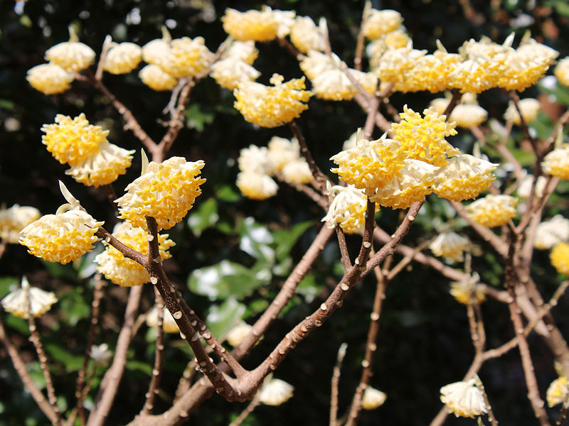
White forsythia are now coming into bloom at the New York Botanical Garden.

-
Under brilliant sunshine, the temperature topped out in the middle 60s across parts of the region. The warmth will peak tomorrow through Friday with the temperature rising into the middle and upper 60s in the New York City area and middle and perhaps upper 70s from Philadelphia and southward. The generally mild conditions will persist through mid-month. There is good consensus on the guidance that a deep trough will likely develop just after mid-month. However, as has generally been the case this winter, no direct Arctic shots are likely. As a result, any cold will likely not be severe for the season and the potential exists for the cooler period to last one to perhaps two weeks, much as occurred in February. Any sharper cold shots will likely have a short duration. The closing days of the month could turn warmer. No significant snowfall appears likely in the northern Middle Atlantic region through at least March 15th. The probability of an unprecedented second consecutive winter with less than 10" seasonal snowfall in New York City's Central Park has continued to increase. Records go back to 1869. The ENSO Region 1+2 anomaly was +1.0°C and the Region 3.4 anomaly was +1.4°C for the week centered around March 6. For the past six weeks, the ENSO Region 1+2 anomaly has averaged +0.98°C and the ENSO Region 3.4 anomaly has averaged +1.53°C. A basinwide El Niño event is ongoing. The ongoing El Niño event will continue to fade during March. Neutral conditions could develop during the spring. The SOI was -5.60 today. The preliminary Arctic Oscillation (AO) was -1.335 today. Based on sensitivity analysis applied to the latest guidance, there is an implied 90% probability that New York City will have a warmer than normal March (1991-2020 normal). March will likely finish with a mean temperature near 46.5° (3.7° above normal).
-
In South Africa, summer has ended. Unfortunately, there's no skill whatsoever on cloud forecasts from this far out.