

donsutherland1
-
Posts
24,194 -
Joined
Content Type
Profiles
Blogs
Forums
American Weather
Media Demo
Store
Gallery
Everything posted by donsutherland1
-
I ran into some pea-sized hail about 60 miles east of Binghamton.
-
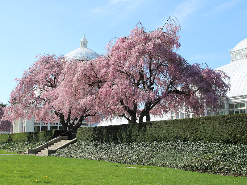
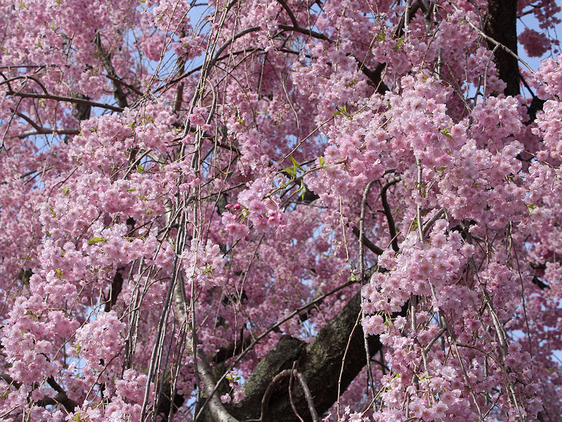
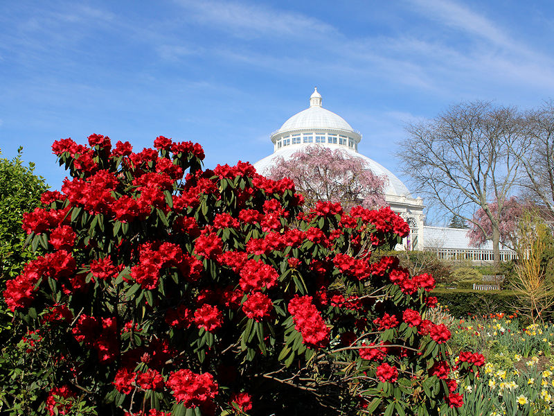
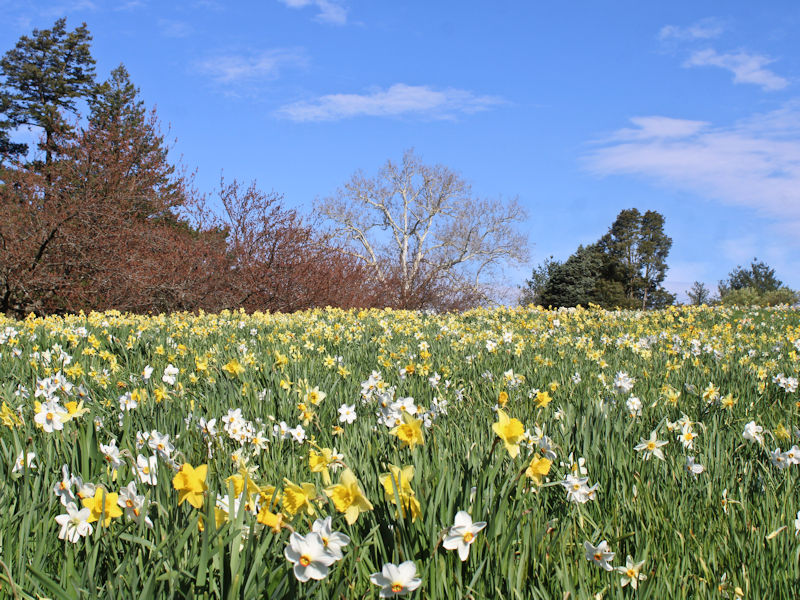
Spring is now in full bloom at the New York Botanical Garden. Some photos from this morning:


-
Occasional Thoughts on Climate Change
donsutherland1 replied to donsutherland1's topic in Climate Change
There's more to the story. When the authors of the papers that expressed no view in the abstract regarding AGW were asked to self-rate their positions, more than 60% endorsed AGW. Rejection of AGW languished at 1.8%. In short, very few scientists actually reject AGW. The majority endorse it. https://iopscience.iop.org/article/10.1088/1748-9326/8/2/024024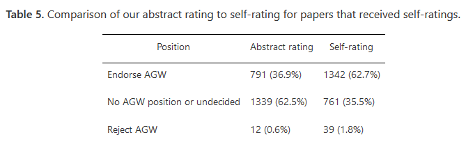
-
Tomorrow will turn noticeably warmer under partly sunny skies. The temperature will rise into the upper 60s and perhaps lower 70s. Monday and Tuesday will be warm days with widespread readings in the 70s. Afterward, it will turn somewhat cooler with unsettled conditions before a stronger cold shot arrives during the next weekend. The ENSO Region 1+2 anomaly was -0.1°C and the Region 3.4 anomaly was +1.2°C for the week centered around April 3. For the past six weeks, the ENSO Region 1+2 anomaly has averaged +0.28°C and the ENSO Region 3.4 anomaly has averaged +1.22°C. The ongoing basinwide El Niño event is fading. Neutral conditions could develop later in the spring. The SOI was +4.97 today. The preliminary Arctic Oscillation (AO) was +3.926 today. Based on sensitivity analysis applied to the latest guidance, there is an implied 65% probability that New York City will have a warmer than normal April (1991-2020 normal). April will likely finish with a mean temperature near 55.6° (2.0° above normal).
-
In the wake of the area's most recent storm, a dry weekend will follow. It will turn briefly cooler tomorrow with a gusty breeze, but warmer air will quickly return starting on Sunday. Temperatures will likely reach the 70s early next week. For the week, temperatures will wind up warmer to much warmer than normal overall. Cooler conditions could follow afterward. Given the near-term warmth and extended guidance, New York City's Central Park is all but certain to finish the 2023-2024 snow season with less than 10" of seasonal snowfall for a record second consecutive season. Records go back to 1869. This will be the last reference to seasonal snowfall for Winter 2023-2024. The ENSO Region 1+2 anomaly was -0.1°C and the Region 3.4 anomaly was +1.2°C for the week centered around April 3. For the past six weeks, the ENSO Region 1+2 anomaly has averaged +0.28°C and the ENSO Region 3.4 anomaly has averaged +1.22°C. The ongoing basinwide El Niño event is fading. Neutral conditions could develop later in the spring. The SOI was -9.74 today. The preliminary Arctic Oscillation (AO) was +3.838 today. Based on sensitivity analysis applied to the latest guidance, there is an implied 68% probability that New York City will have a warmer than normal April (1991-2020 normal). April will likely finish with a mean temperature near 55.8° (2.2° above normal).
-
Occasional Thoughts on Climate Change
donsutherland1 replied to donsutherland1's topic in Climate Change
On the issue of mitigation vs. adaptation, I would rather see much more attention devoted to mitigation, even at the expense of adaptation. An investment in mitigation would yield far bigger returns than a strategy aimed largely at adaptation. The former would limit the consequences. The latter would delay mitigation and amount to perhaps a down payment into an even worse future. Ultimately, adaptation would be largely futile if the world descends into a Mid-Pliocene-type climate with an irrevocable commitment to extreme heat, devastating floods, and a long-term 25-meter sea level rise. Yet, humanity remains far from making a credible effort aimed at mitigating climate change. For all of humanity's lofty achievements and acquisition of knowledge (some of which is being rejected by climate change denial and those with a stake in it), humanity is incredibly bad at looking beyond the near-term and in solving complex societal problems. It views the future as little more than a linear extension of the present despite overwhelming evidence that the future is anything but a linear extension of the present. It seeks to sustain an unsustainable status quo where resources are being consumed far faster than they can be renewed. It places blind faith in technological miracles that would arrive just in time to avert the consequences of its choice not to address climate change, among other big issues. It wholesale ignores physics, even as physics as provided insight into the greenhouse effect since the 19th century and a correct long-range forecast from decades ago that an increase in greenhouse gases would lead to warming. In 1987, Lamont-Doherty scientist Wallace S. Broecker observed: The inhabitants of planet Earth are quietly conducting a gigantic environmental experiment. So vast and so sweeping will be the consequences that, were it brought before any responsible council for approval, it would be firmly rejected. Yet it goes on with little interference from any jurisdiction or nation. The failure of COP 28, which convened 36 years after Dr. Broecker's observation and following the IPCC's declaration that it is "unequivocal" that human activities have warmed the climate, to adopt even a minimal set of targets for weaning the world off its fossil fuel addiction reaffirmed the continuing relevance of Dr. Broeker's observation. Today, as the world still has a choice, its decision not to adopt a credible course of action is one of willful and knowing choice. 2022 and 2023 were defined by extremes in precipitation events, heat, global temperatures, and sea surface temperatures. None of that shook COP 28 or the world's leaders from their lazy complacency, even as technologies already exist for a much faster shift from fossil fuels than had been possible in 1987. Broecker warned, "We play Russian roulette with climate, hoping that the future will hold no unpleasant surprises." The geological record shows that there have been times where the climate has made rapid, large-scale changes from a preceding state. The sudden enormous spike in sea surface temperatures, which remain near record highs and lack of consensus among the scientific community about the overall cause illustrates the reality that one can't be fully certain about what lies ahead beyond the skillful (to date) predictions about global temperatures. Broecker advised, "To prepare ourselves, we must take the problem of climatic change as seriously as we take those of cancer and nuclear defense." That has not been the case among the world's political leaders through the opening of 2024. Sure, there have been words. However, actions speak much more credibly. The absence of binding targets for fossil fuel burning and the lack of a credible path for a reduction consistent with achieving net zero emissions by 2050 speak far more authoritatively than the sum total of all the political rhetoric since climate change first burst onto the political scene in a big way with Dr. James Hansen's June 23, 1988 Congressional testimony. Then, Hansen declared, "...the greenhouse effect has been detected, and it is changing our climate now." Political indifference followed when it came to concrete and credible actions. Energy consumption from fossil fuels rose from 77.9 terawatt hours in 1988 to 13.2 terawatt hours in 2022, a 76% increase. Atmospheric CO2 increased from 351.7 PPM in 1988 to 421.1 PPM in 2023, a 20% increase. Humanity knowingly and deliberately invested in a warmer more unstable climate. At COP 28, it reaffirmed that tragic commitment. 2024 has begun in the shadow of humanity's latest choice to put efforts to preserve an unsustainable fossil fuel-centric status quo ahead of urgent and credible mitigation. -
A 1926-type hit on Miami would be far more damaging today.
-
Periods of rain and some thunderstorms are likely tonight into tomorrow. Much of the region will pick up 0.50"-1.50" of rain with some locally higher amounts. The wind could gust past 40 mph tonight into tomorrow. In the wake of the storm, a dry weekend will follow. It will turn briefly cooler on Saturday, but warmer air will quickly return starting on Sunday. Temperatures could again reach the 70s early next week.Even warmer temperatures are possible. Given the near-term warmth and extended guidance, New York City's Central Park is all but certain to finish the 2023-2024 snow season with less than 10" of seasonal snowfall for a record second consecutive season. Records go back to 1869. The ENSO Region 1+2 anomaly was -0.1°C and the Region 3.4 anomaly was +1.2°C for the week centered around April 3. For the past six weeks, the ENSO Region 1+2 anomaly has averaged +0.28°C and the ENSO Region 3.4 anomaly has averaged +1.22°C. The ongoing basinwide El Niño event is fading. Neutral conditions could develop later in the spring. The SOI was -15.14 today. The preliminary Arctic Oscillation (AO) was +3.117 today. Based on sensitivity analysis applied to the latest guidance, there is an implied 79% probability that New York City will have a warmer than normal April (1991-2020 normal). April will likely finish with a mean temperature near 56.1° (2.5° above normal).
-
I'm glad Watertown did well. The City had planned a huge event and it was important that things worked out.
-
Yes. Fixed it.
-
This is likely a key point if one is looking far ahead to next winter. The balance of early odds seems to favor another warm winter with low snowfall, but skill this far out is essentially non-existent.
-
Rain will arrive toward morning. Tomorrow will see periods of rain but it will remain mild. Much of the region will pick up 0.50"-1.50" of rain with some locally higher amounts. Thunderstorms and gusty winds are possible. In the wake of the storm, a dry weekend will follow. It will turn briefly cooler on Saturday, but warmer air will quickly return starting on Sunday. Temperatures could again reach the 70s early next week. Even warmer temperatures are possible. Given the near-term warmth and extended guidance, New York City's Central Park is all but certain to finish the 2023-2024 snow season with less than 10" of seasonal snowfall for a record second consecutive season. Records go back to 1869. The ENSO Region 1+2 anomaly was -0.1°C and the Region 3.4 anomaly was +1.2°C for the week centered around April 3. For the past six weeks, the ENSO Region 1+2 anomaly has averaged +0.28°C and the ENSO Region 3.4 anomaly has averaged +1.22°C. The ongoing basinwide El Niño event is fading. Neutral conditions could develop later in the spring. The SOI was -1.08 today. The preliminary Arctic Oscillation (AO) was +2.290 today. Based on sensitivity analysis applied to the latest guidance, there is an implied 80% probability that New York City will have a warmer than normal April (1991-2020 normal). April will likely finish with a mean temperature near 56.2° (2.6° above normal).
-
This is one aspect of modeling that still has ample room for improvement. I am glad that some of the areas that looked unfavorable on the guidance actually had good views of the solar eclipse. The National Blend of Models did quite well within 36 hours for some areas, but not all. The GFS might have done worst of all, though I didn't check it once I had departed for the eclipse.
-
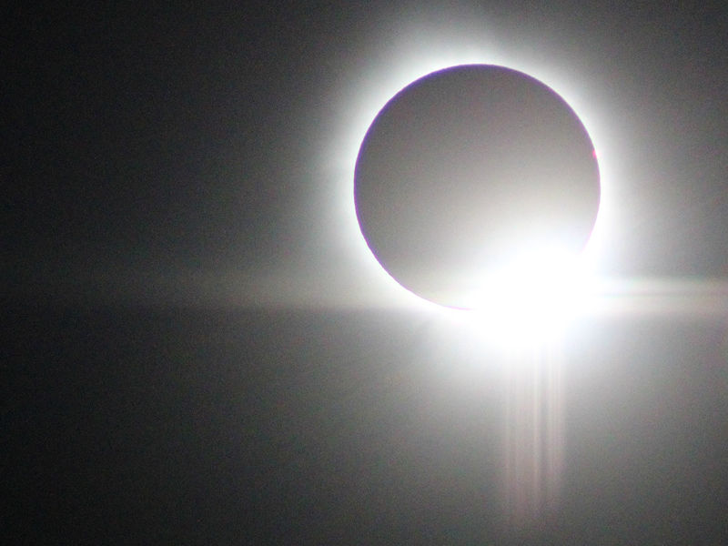
Purkinje Effect from the solar eclipse. Notice the purple and blue at the edge of the sun.
- 308 replies
-
- 15
-

-
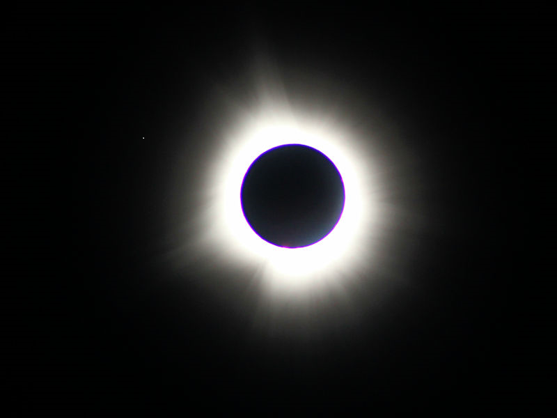
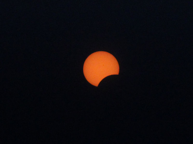
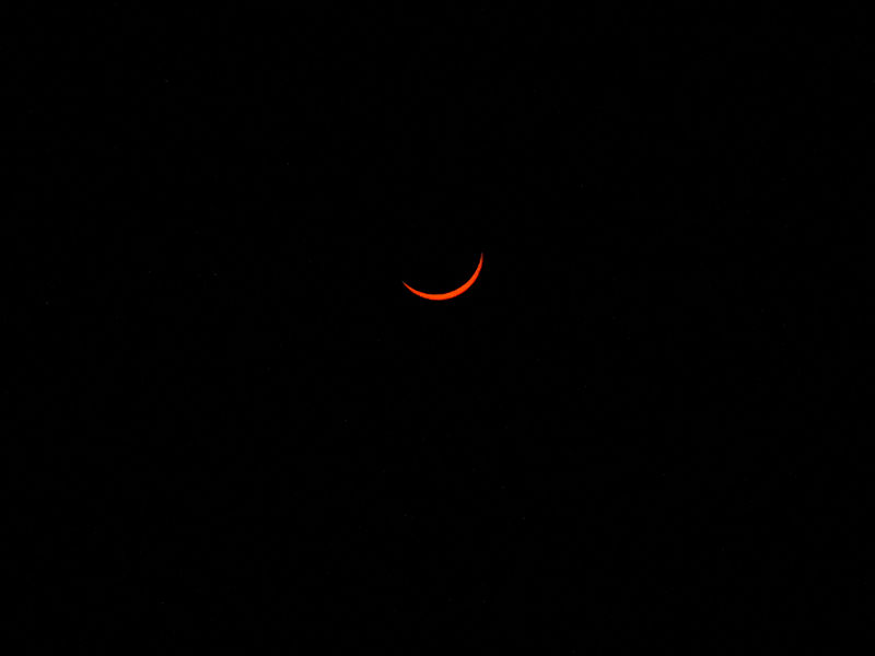
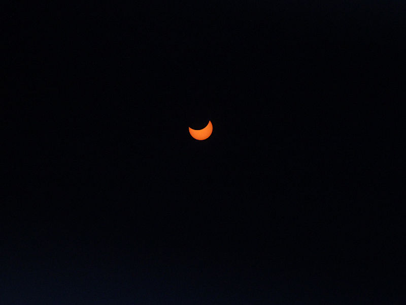
Six photos from the April 8, 2024 solar eclipse taken at Moose River, Maine.

- 308 replies
-
- 13
-
-

-
Yes. That’s true.
-
Plattsburgh is probably better than Lake Placid. Burlington or Montreal would probably be better.
-
Last second change to Maine due to risk of clouds in Plattsburgh area. Gorgeous sunrise.
-
Tomorrow will again feature readings in the 50s. Afterward, it will likely turn noticeably warmer. Monday should see partly to mostly sunny skies, allowing for good viewing of the solar eclipse in the New York City area. The temperature should top out in the lower 60s. The highest probability of minimal cloud cover in the path of totality in the Northeast will likely be across northern New England, particularly Maine. The warmest day of the week will likely be Tuesday when temperatures rise into perhaps the lower 70s in New York City and upper 70s to perhaps near 80° in Washington, DC. A moderate to significant rainfall is possible late in the week with much of the region picking up a general 1.00"-2.00" of rain. New York City's Central Park remains on track to finish the 2023-2024 snow season with less than 10" of seasonal snowfall for a record second consecutive season. Records go back to 1869. The ENSO Region 1+2 anomaly was -0.4°C and the Region 3.4 anomaly was +1.0°C for the week centered around March 27. For the past six weeks, the ENSO Region 1+2 anomaly has averaged +0.42°C and the ENSO Region 3.4 anomaly has averaged +1.27°C. The ongoing basinwide El Niño event is fading. Neutral conditions could develop later in the spring. The SOI was -18.32 today. The preliminary Arctic Oscillation (AO) was +0.182 today.
-
The Ramapo Fault is an old one. I'm sure some research has been done.
-
Revisions are often based on the examination of a wider set of data.
-
Thank you.
-
Unfortunately, the paper from which I got the earlier figures didn't provide technical information about how the measurements were made.
-
I am sorry to learn of your dad’s passing. You have my fullest condolences.
-
The aftershock that was initially shown at M4.0 was reduced to M3.8.

