donsutherland1
-
Posts
24,194 -
Joined
Content Type
Profiles
Blogs
Forums
American Weather
Media Demo
Store
Gallery
Everything posted by donsutherland1
-
It has been exceptional. One location in South Africa had a high of 117.
-
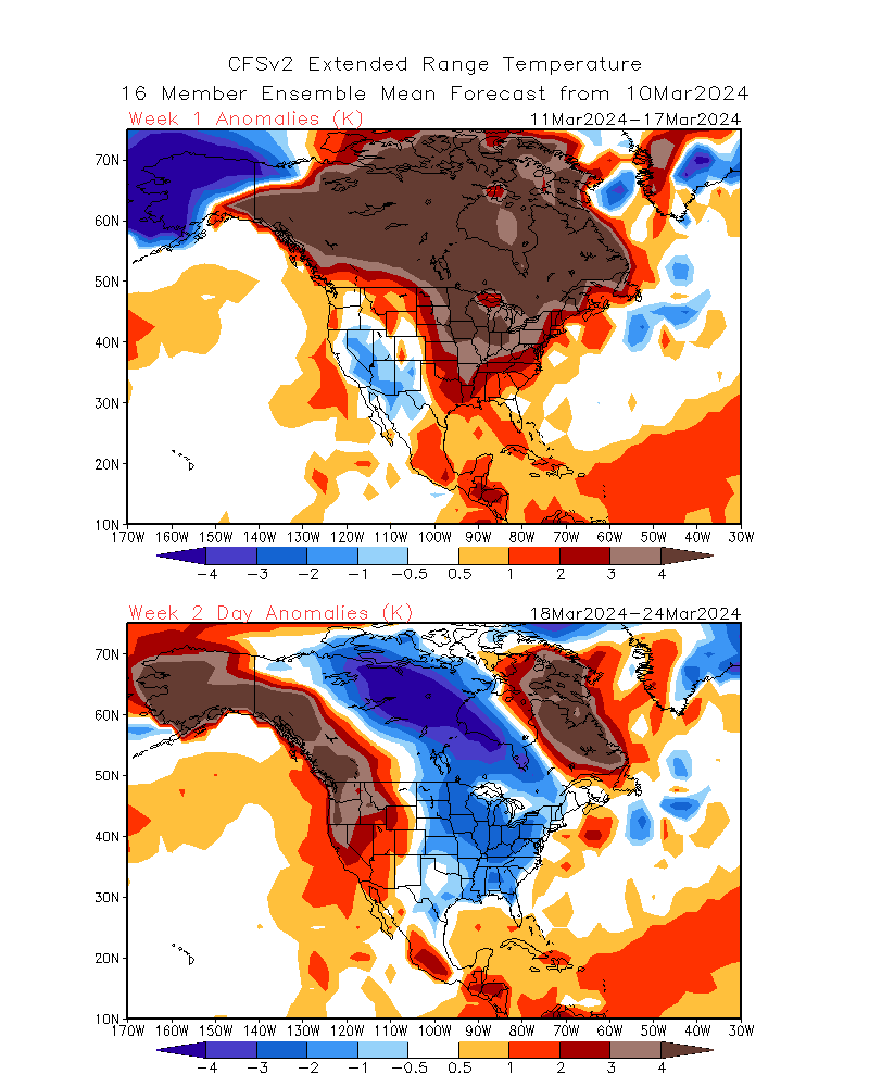
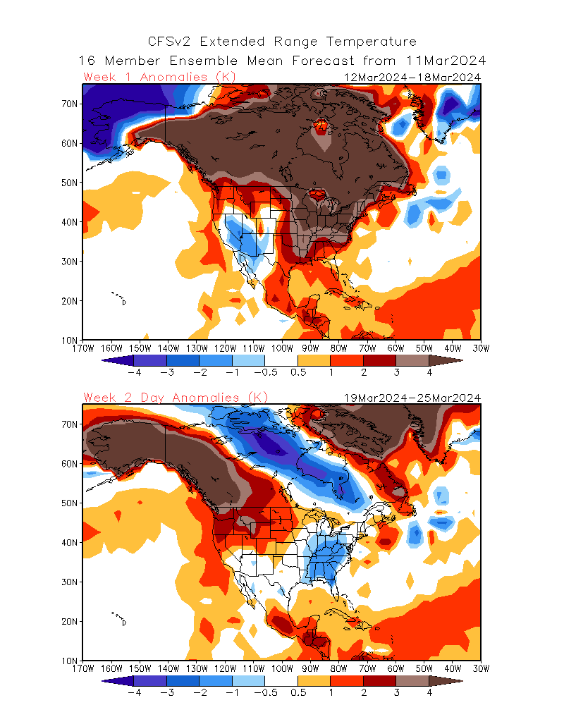
The CFSv2 also shows less cold air for Week 2: March 10: March 11:
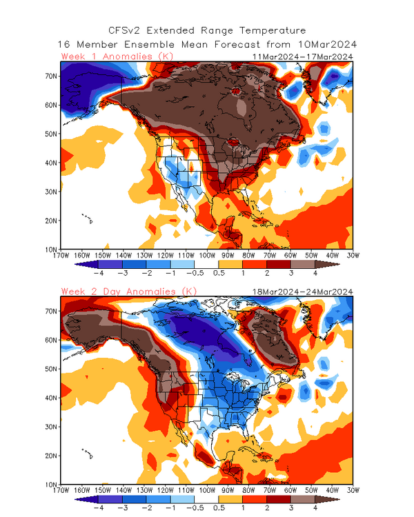
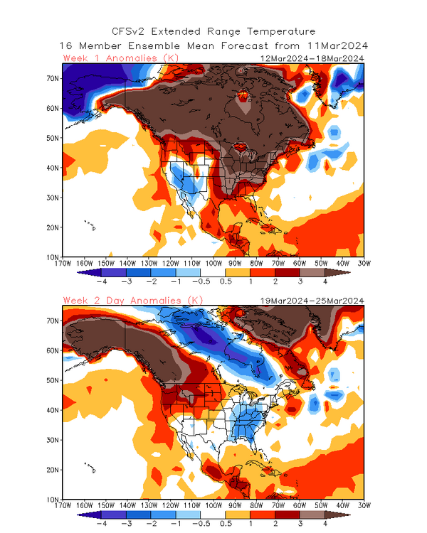
-
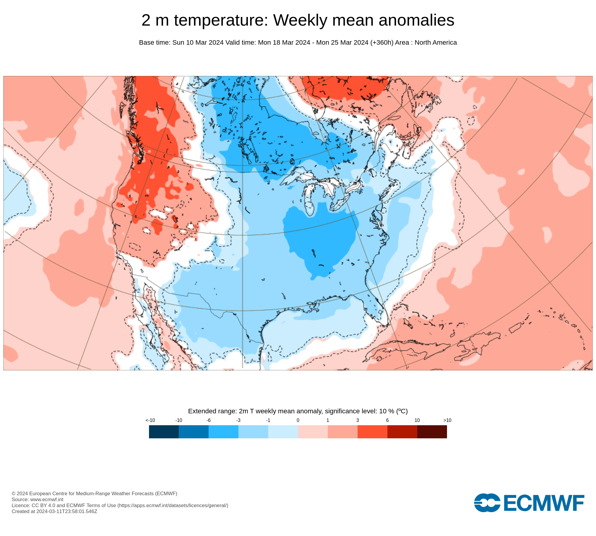
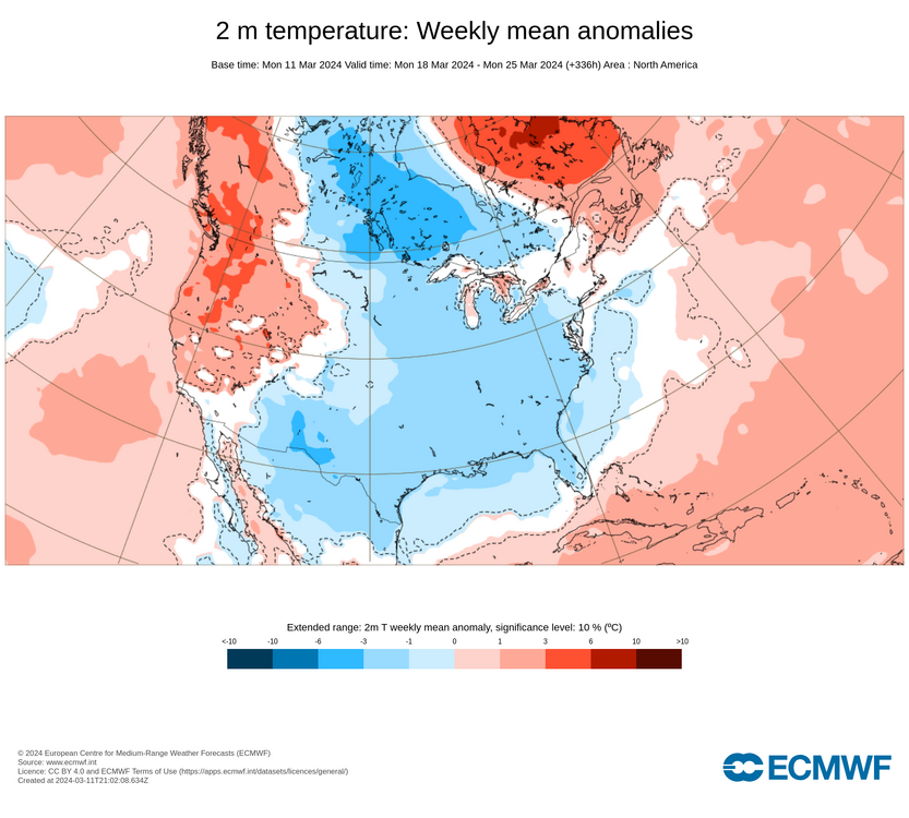
Is an old story set to play out yet again? ECMWF Weeklies for March 18-25 from March 10: ECMWF Weeklies for March 18-25 from March 11:

-
The wind, which gusted past 50 mph in much of the region today will gradually diminish overnight. Afterward, it will seem as if the calendar had been turned forward into April. It will turn noticeably milder starting tomorrow. The warmth will peak during Wednesday through Friday with the temperature rising into the lower and middle 60s in the New York City area and lower and middle 70s from Philadelphia and southward. The generally mild conditions will persist through mid-month. There is growing consensus on the guidance that a deep trough could develop just after mid-month. However, as has generally been the case this winter, no direct Arctic shots are likely. As a result, any cold will likely not be severe for the season and the potential exists for the cooler period to last one to perhaps two weeks, much as occurred in February. Any sharper cold shots will likely have a short duration. The closing days of the month could turn warmer. No significant snowfall appears likely in the northern Middle Atlantic region through at least March 15th. The probability of an unprecedented second consecutive winter with less than 10" seasonal snowfall in New York City's Central Park has increased. Records go back to 1869. The ENSO Region 1+2 anomaly was +1.0°C and the Region 3.4 anomaly was +1.4°C for the week centered around March 6. For the past six weeks, the ENSO Region 1+2 anomaly has averaged +0.98°C and the ENSO Region 3.4 anomaly has averaged +1.53°C. A basinwide El Niño event is ongoing. The ongoing El Niño event will continue to fade during March. Neutral conditions could develop during the spring. The SOI was -3.16 today. The preliminary Arctic Oscillation (AO) was -1.287 today. Based on sensitivity analysis applied to the latest guidance, there is an implied 86% probability that New York City will have a warmer than normal March (1991-2020 normal). March will likely finish with a mean temperature near 46.2° (3.4° above normal).
-
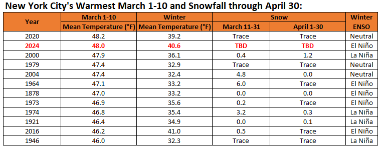
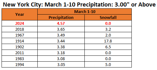
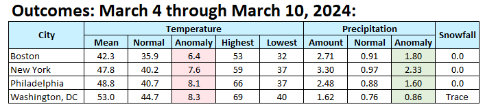
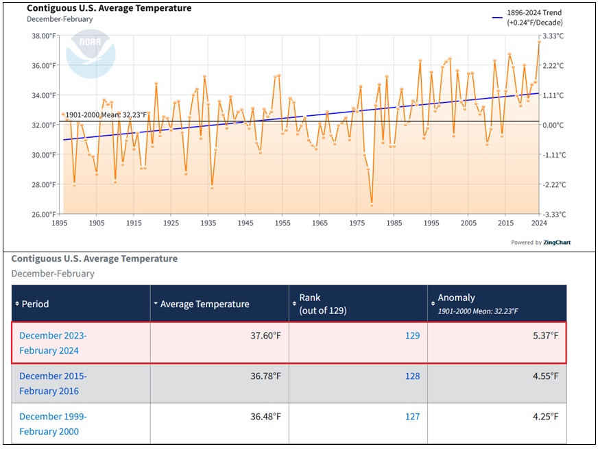
March 1-10, 2024 was the second warmest such period on record in New York City. It was also the wettest such period on record with 4.57" of precipitation (old record: 3.65", 2018).
-
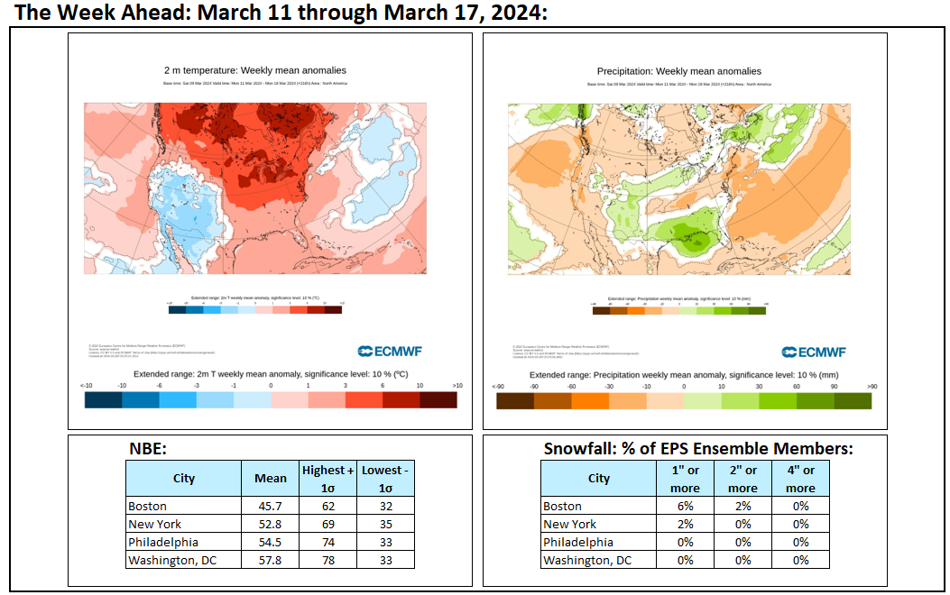
Final outcome: A very warm and very wet week.
-
Congratulations.
-
Following afternoon showers, some of which were mixed with wet snowflakes and graupel, the temperature fell into the lower 40s and a gusty wind picked up. Tomorrow will be a brisk day. Afterward, it will turn noticeably milder. The warmth will peak during Wednesday through Friday with the temperature rising into the lower and middle 60s in the New York City area and lower and middle 70s from Philadelphia and southward. The generally mild conditions will persist through mid-month. There is growing consensus on the guidance that a deep trough could develop just after mid-month. However, as has generally been the case this winter, no direct Arctic shots are likely. As a result, any cold will likely not be severe for the season and the potential exists for the cooler period to last one to perhaps two weeks, much as occurred in February. Any sharper cold shots will likely have a short duration. The closing days of the month could turn warmer. No significant snowfall appears likely in the northern Middle Atlantic region through at least March 15th. The probability of an unprecedented second consecutive winter with less than 10" seasonal snowfall in New York City's Central Park has increased. Records go back to 1869. The ENSO Region 1+2 anomaly was +0.9°C and the Region 3.4 anomaly was +1.3°C for the week centered around February 28. For the past six weeks, the ENSO Region 1+2 anomaly has averaged +0.93°C and the ENSO Region 3.4 anomaly has averaged +1.58°C. A basinwide El Niño event is ongoing. The ongoing El Niño event will continue to fade during March. Neutral conditions could develop during the spring. The SOI was +6.46 today. The preliminary Arctic Oscillation (AO) was -1.652 today. Based on sensitivity analysis applied to the latest guidance, there is an implied 85% probability that New York City will have a warmer than normal March (1991-2020 normal). March will likely finish with a mean temperature near 46.2° (3.4° above normal).
-
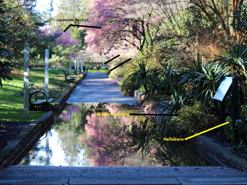
I took it this morning at the New York Botanical Garden. All of the Japanese Apricot trees are in full bloom now. Four are in bloom at one location and the additional Japanese Apricot is in bloom at a separate location. It's really unusual. Here's the EXIF data: Some of what's currently in bloom at the Ladies' Border Garden at the New York Botanical Garden: Not pictured: Adonis and Camelia.

-
June analog: 1816.
-
There is rain with a little wet snow mixing in at Larchmont.
-
JB. Enough said.
-
Following last night's rainstorm at the New York Botanical Garden.


-
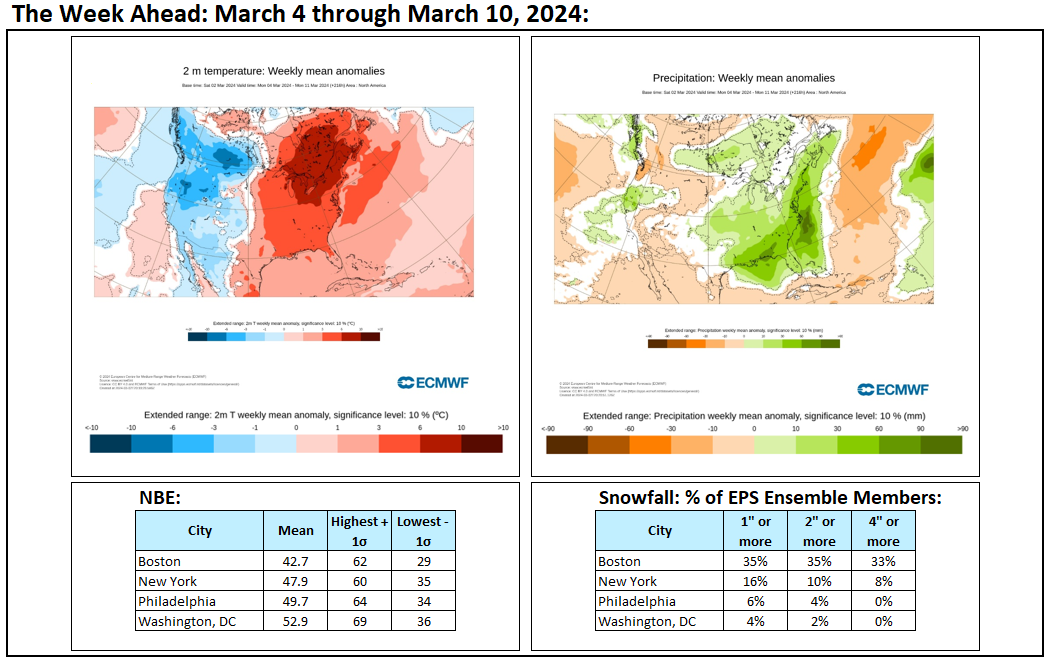
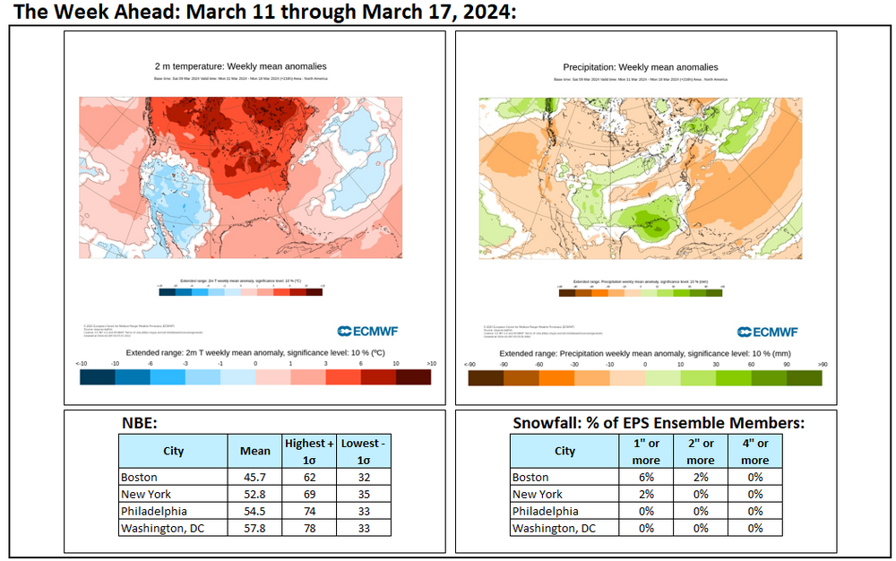
Week ahead numbers: A very warm and generally dry week lies ahead.
-
Rain, some of which will fall heavily, will continue into tomorrow morning. A general 0.50"-1.50" rainfall is likely by the time the storm ends. Coastal flooding is likely at times of high tide. Winds could gust past 40 mph during the storm. A period of drier weather will follow the storm's departure. After a brisk days tomorrow and Monday, it will turn noticeably milder. The warmth will peak on Thursday and Friday with the temperature rising into the lower and middle 60s in the New York City area and lower and middle 70s from Philadelphia and southward. The generally mild conditions will persist through mid-month. Afterward, there is growing consensus on the guidance that a deep trough could develop. However, as has generally been the case this winter, no Arctic air masses are likely. As a result, any cold will likely not be severe for the season and the potential exists for it to last one to perhaps two weeks, much as occurred in February. Any sharper cold shots will likely have a short duration. No significant snowfall appears likely in the northern Middle Atlantic region through at least March 15th. The probability of an unprecedented second consecutive winter with less than 10" seasonal snowfall in New York City's Central Park has increased. Records go back to 1869. The ENSO Region 1+2 anomaly was +0.9°C and the Region 3.4 anomaly was +1.3°C for the week centered around February 28. For the past six weeks, the ENSO Region 1+2 anomaly has averaged +0.93°C and the ENSO Region 3.4 anomaly has averaged +1.58°C. A basinwide El Niño event is ongoing. The ongoing El Niño event will continue to fade during March. Neutral conditions could develop during the spring. The SOI was +5.26 today. The preliminary Arctic Oscillation (AO) was -1.831 today. Based on sensitivity analysis applied to the latest guidance, there is an implied 82% probability that New York City will have a warmer than normal March (1991-2020 normal). March will likely finish with a mean temperature near 46.0° (3.2° above normal).
-
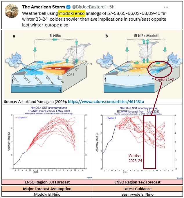
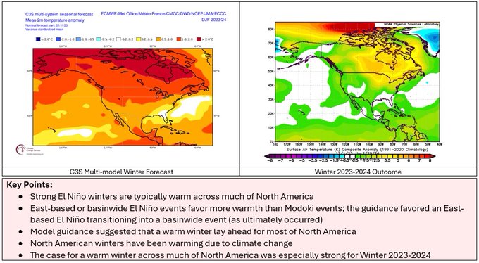
Early on, it was clear that he was going against the guidance when he called for a Modoki El Niño. No guidance showed a Modoki event. From last year: Forecast assumptions should be evidence-informed. Relying on evidence provides no guarantee of success given the limitations of long range guidance, but it gives one a better chance at verification. At the same time, one should have the courage to adjust the forecast when developments warrant adjustment rather than doubling down on one’s ideas. Further, one should avoid confirmation bias from only choosing guidance that agrees with one’s thinking, especially when such guidance is an outlier. Finally, the climate context matters. The shift in SSTAs, impact of ongoing marine heatwaves, smaller pool of deep cold, etc., render past analogs irrelevant unless they are adjusted. In the end, the winter guidance was very accurate for North America.
-
Waiting for the rain:
-
Sunshine dominated the day today. In response, the mercury rose into the middle 50s. The respite from rainfall is nearing an end with the approach of yet another storm. Tomorrow will be increasingly cloudy. Rain will arrive during the afternoon or evening hours. A general 0.50"-1.50" rainfall is likely. A period of drier weather will follow the storm's departure. An extended period of warmer than normal weather continues. The generally mild conditions could persist through mid-month. Afterward, there is emerging consensus on the guidance that a deep trough could develop. However, as has generally been the case this winter, no Arctic air masses are likely. As a result, any cold will likely not be severe for the season and the potential exists for it to be fairly short-lived (1 to perhaps 2 weeks in duration), much as occurred in February. No significant snowfall appears likely in the northern Middle Atlantic region through at least March 10th. The probability of an unprecedented second consecutive winter with less than 10" seasonal snowfall in New York City's Central Park has increased. Records go back to 1869. The ENSO Region 1+2 anomaly was +0.9°C and the Region 3.4 anomaly was +1.3°C for the week centered around February 28. For the past six weeks, the ENSO Region 1+2 anomaly has averaged +0.93°C and the ENSO Region 3.4 anomaly has averaged +1.58°C. A basinwide El Niño event is ongoing. The ongoing El Niño event will continue to fade during March. Neutral conditions could develop during the spring. The SOI was -7.95 today. The preliminary Arctic Oscillation (AO) was -1.120 today. Based on sensitivity analysis applied to the latest guidance, there is an implied 79% probability that New York City will have a warmer than normal March (1991-2020 normal). March will likely finish with a mean temperature near 46.0° (3.2° above normal).
-
Some additional data:
-
Drier air moved into the region today in the wake of yesterday's soaking, but the clouds lingered throughout much of the day. Tomorrow will feature abundant sunshine and pleasantly mild readings in the 50s. However, the respite from rainfall will be brief. Another storm will likely bring rain to the region during the weekend. The potential exists for a general 0.50"-1.50" rainfall. A period of drier weather should follow. An extended period of warmer than normal weather continues. The generally mild conditions could persist through mid-month. Afterward, there is emerging consensus on the guidance that a deep trough could develop. However, as has generally been the case this winter, no Arctic air masses are likely. As a result, any cold will likely not be severe for the season and the potential exists for it to be fairly short-lived (1 to perhaps 2 weeks in duration), much as occurred in February. No significant snowfall appears likely in the northern Middle Atlantic region through at least March 10th. The probability of an unprecedented second consecutive winter with less than 10" seasonal snowfall in New York City's Central Park has increased. Records go back to 1869. The ENSO Region 1+2 anomaly was +0.9°C and the Region 3.4 anomaly was +1.3°C for the week centered around February 28. For the past six weeks, the ENSO Region 1+2 anomaly has averaged +0.93°C and the ENSO Region 3.4 anomaly has averaged +1.58°C. A basinwide El Niño event is ongoing. The ongoing El Niño event will continue to fade during March. Neutral conditions could develop during the spring. The SOI was -7.71 today. The preliminary Arctic Oscillation (AO) was -0.578 today. Based on sensitivity analysis applied to the latest guidance, there is an implied 82% probability that New York City will have a warmer than normal March (1991-2020 normal). March will likely finish with a mean temperature near 46.0° (3.2° above normal).
-
A storm will dump a general 1"-2" of rain through tonight into early tomorrow. The rain could fall heavily at times creating ponding on roadways and possible flooding along streams. Locally higher rainfall amounts are possible. Yet another storm will likely bring rain to the region during the weekend. An extended period of warmer than normal weather continues. The generally mild conditions could persist through mid-month. Afterward, there is emerging consensus on the guidance that a deep trough could develop. However, as has generally been the case this winter, no Arctic air masses are likely. As a result, any cold will likely not be severe for the season and the potential exists for it to be fairly short-lived, much as occurred in February. No significant snowfall appears likely in the northern Middle Atlantic region through at least March 10th. The probability of an unprecedented second consecutive winter with less than 10" seasonal snowfall in New York City's Central Park has increased. Records go back to 1869. The ENSO Region 1+2 anomaly was +0.9°C and the Region 3.4 anomaly was +1.3°C for the week centered around February 28. For the past six weeks, the ENSO Region 1+2 anomaly has averaged +0.93°C and the ENSO Region 3.4 anomaly has averaged +1.58°C. A basinwide El Niño event is ongoing. The ongoing El Niño event will continue to fade during March. Neutral conditions could develop during the spring. The SOI was -3.54 today. The preliminary Arctic Oscillation (AO) was -0.511 today.
-
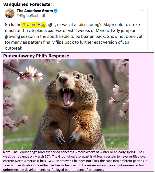
A vanquished forecaster has attempted to shift the timeframe to undo the Groundhog's verification. From outside his burrow among the blossoms, Punxsutawney Phil has responded.
-
The temperature again soared to daily record highs in parts of Ontario, Quebec, and western New York State. However, a storm brought periods of rain and cooler onshore breezes to the northern Mid-Atlantic region today. Rain will end overnight, but the respite will be short. Another storm will drench the region with a general 1"-2" of rain later tomorrow into Thursday. Locally higher amounts are possible. Yet another storm could bring rain to the region during the weekend. An extended period of warmer than normal weather continues. March will likely see generally unseasonable warmth through the first 7-10 days of the month. The first week of March could see the temperature average near 10° above normal in New York City. The generally mild conditions could persist through mid-month. Afterward, there is emerging consensus on the guidance that a deep trough could develop. However, as has generally been the case this winter, no Arctic air masses are likely. As a result, any cold will likely not be severe for the season and the potential exists for it to be fairly short-lived, much as occurred in February. No significant snowfall appears likely in the northern Middle Atlantic region through at least March 10th. The probability of an unprecedented second consecutive winter with less than 10" seasonal snowfall in New York City's Central Park has increased. Records go back to 1869. The ENSO Region 1+2 anomaly was +0.9°C and the Region 3.4 anomaly was +1.3°C for the week centered around February 28. For the past six weeks, the ENSO Region 1+2 anomaly has averaged +0.93°C and the ENSO Region 3.4 anomaly has averaged +1.58°C. A basinwide El Niño event is ongoing. The ongoing El Niño event will continue to fade during March. Neutral conditions could develop during the spring. The SOI was -2.87 today. The preliminary Arctic Oscillation (AO) was -0.507 today.
-
Considerable cloud cover and a light onshore breeze capped temperatures across the region today. Nevertheless, temperatures again ran much above normal for the day. Meanwhile, parts of Ontario and western New York State saw record warmth today. Records included: Buffalo: 72° (old record: 63°, 1974) Detroit: 74° (old record: 69°, 1983) ***Earliest 74° or above temperature on record*** Kingston, ON: 58° (old record: 46°, 1974) London, ON: 67° (old record: 59°, 1966) Ottawa: 53° (old record: 50°, 1965) Toronto: 61° (old record: 56°, 1974) Rochester: 72° (old record: 69°, 1974) Watertown: 67° (old record: 56°, 1974) Windsor: 72° (old record: 66°, 1983) An extended period of warmer to much warmer than normal weather is now underway. March will likely see generally unseasonable warmth through the first 7-10 days of the month. The first week of March could see the temperature average near 10° above normal in New York City. The generally mild conditions could persist through mid-month. However, rainfall totals will likely be above to much above normal. The first in a series of storms will bring rain late tonight through tomorrow to the region. Another storm could bring rain Wednesday into Thursday. Yet another storm could bring rain to the region during the weeend. No significant snowfall appears likely in the northern Middle Atlantic region through at least March 10th. The probability of an unprecedented second consecutive winter with less than 10" seasonal snowfall in New York City has increased. The ENSO Region 1+2 anomaly was +0.9°C and the Region 3.4 anomaly was +1.3°C for the week centered around February 28. For the past six weeks, the ENSO Region 1+2 anomaly has averaged +0.93°C and the ENSO Region 3.4 anomaly has averaged +1.58°C. A basinwide El Niño event is ongoing. The ongoing El Niño event will continue to fade during March. Neutral conditions could develop during the spring. The SOI was -2.87 today. The preliminary Arctic Oscillation (AO) was -0.304 today.
-
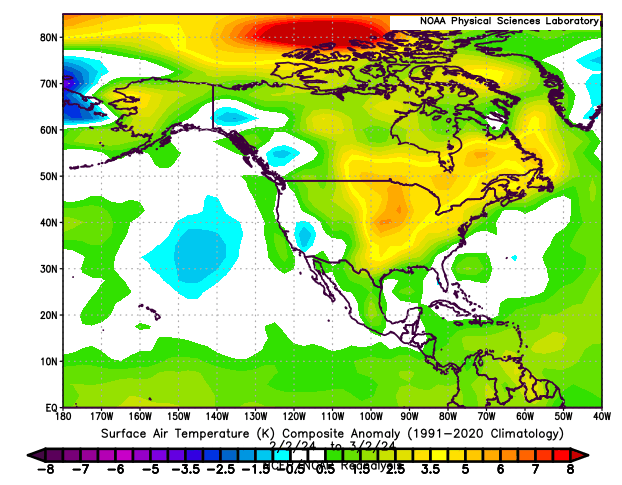
Breaking... Temperature anomalies since Groundhog Day: