donsutherland1
-
Posts
24,194 -
Joined
Content Type
Profiles
Blogs
Forums
American Weather
Media Demo
Store
Gallery
Everything posted by donsutherland1
-
Chicago Weather Records Tracking
donsutherland1 replied to Chicago Storm's topic in Lakes/Ohio Valley
Largest 24-hour change (since hourly records started in 1946): 53 degrees (1/18/1996 9 am: 59; 1/19/1996 9 am: 6). Biggest drop from daily high to next day’s low: 61 degrees (11/11/1911: high of 74; 11/12/1911: low of 13). -
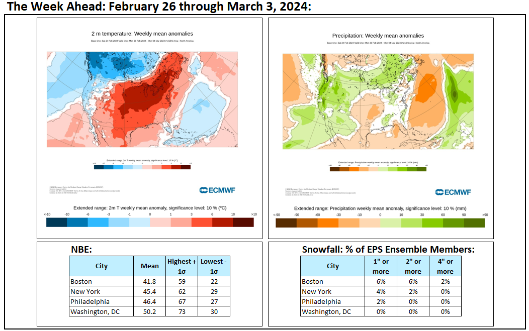
Temperatures soared to daily and even monthly records across the Plains States today. Monthly records were broken in cities that included: Des Moines, Minneapolis, Omaha, and Rockford. Laredo, TX saw the mercury top out at 98°. Minneapolis saw the mercury reach 50° for the 16th time this winter. That doubled the old mark of 8 days from Winter 1980-1981. A piece of this warmth will sweep across the region on Wednesday ahead of a cold front sending readings into the 60s in New York City and Newark and 70s in Baltimore and Washington, DC. An unseasonably mild pattern is now in place. Temperatures will remain generally above normal through the remainder of February. The potential exists for the closing days of February to wind up much warmer than normal overall. However, a brief cold shot could arrive resulting in cool temperatures for February 29th. Little or no additional snowfall is likely in the New York City or Philadelphia areas through the remainder of February. March will likely see generally unseasonable warmth through the first 7-10 days of the month. No significant snowfall appears likely in the northern Middle Atlantic region during that time. Overall, March will likely be warmer than normal. The ENSO Region 1+2 anomaly was +0.7°C and the Region 3.4 anomaly was +1.5°C for the week centered around February 21. For the past six weeks, the ENSO Region 1+2 anomaly has averaged +0.92°C and the ENSO Region 3.4 anomaly has averaged +1.65°C. A basinwide El Niño event is ongoing. The ongoing El Niño event will continue to fade during March. Neutral conditions could develop during the spring. The SOI was +6.63 today. The preliminary Arctic Oscillation (AO) was +2.628 today. On February 24 the MJO was in Phase 7 at an amplitude of 0.128 (RMM). The February 23-adjusted amplitude was 0.383 (RMM). Based on sensitivity analysis applied to the latest guidance, there is an implied near 100% probability that New York City will have a warmer than normal February (1991-2020 normal). February will likely finish with a mean temperature near 39.9° (4.0° above normal). Winter 2023-2024 is on course to finish with a seasonal mean temperature of 40.4°-40.6°. That would rank the current winter among the ten warmest on record in New York City. It would also mark the second time when two consecutive winters have ranked among the top ten in terms of warmth. Winters 2015-2016 and 2016-2017 are currently the only two such winters to rank among the ten warmest on record. Winters 2022-2023 and 2023-2024 will become the first time on record that New York City has seen two consecutive winters with 40.0° or above mean temperatures. Since 1869, there have been six winters with a mean temperature of 40.0° or above. Five have occurred since 2000.
-
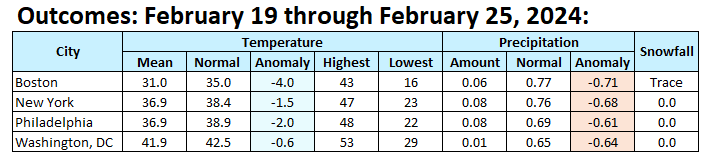
The week was cool but dry.
-
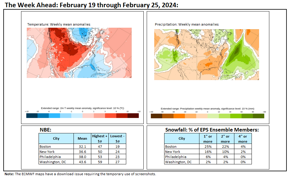
Milder air will overspread the region tomorrow. Afterward, temperatures will remain generally above normal through the remainder of February. The potential exists for the closing days of February to wind up much warmer than normal. Little or no additional snowfall is likely in the New York City or Philadelphia areas through the remainder of February. March will likely begin with generally unseasonable warmth through the first 7-10 days of the month. No significant snowfall appears likely in the northern Middle Atlantic region during that time. Overall, March will likely be warmer than normal. The ENSO Region 1+2 anomaly was +1.1°C and the Region 3.4 anomaly was +1.5°C for the week centered around February 14. For the past six weeks, the ENSO Region 1+2 anomaly has averaged +0.95°C and the ENSO Region 3.4 anomaly has averaged +1.72°C. A basinwide El Niño event is ongoing. The ongoing El Niño event will continue to fade during March. Neutral conditions could develop during the spring. The SOI was +2.83 today. The preliminary Arctic Oscillation (AO) was +2.071 today. On February 23 the MJO was in Phase 6 at an amplitude of 0.383 (RMM). The February 22-adjusted amplitude was 0.343 (RMM). Based on sensitivity analysis applied to the latest guidance, there is an implied near 100% probability that New York City will have a warmer than normal February (1991-2020 normal). February will likely finish with a mean temperature near 39.9° (4.0° above normal). Winter 2023-2024 is on course to finish with a seasonal mean temperature of 40.4°-40.6°. That would rank the current winter among the ten warmest on record in New York City. It would also mark the second time when two consecutive winters have ranked among the top ten in terms of warmth. Winters 2015-2016 and 2016-2017 are currently the only two such winters to rank among the ten warmest on record. Winters 2022-2023 and 2023-2024 will become the first time on record that New York City has seen two consecutive winters with 40.0° or above mean temperatures. Since 1869, there have been six winters with a mean temperature of 40.0° or above. Five have occurred since 2000.
-
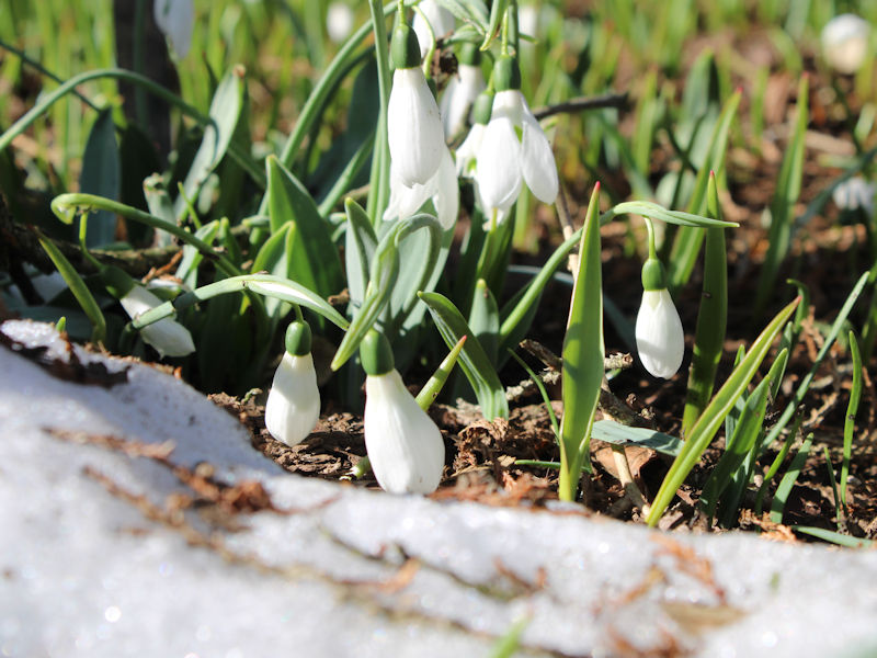
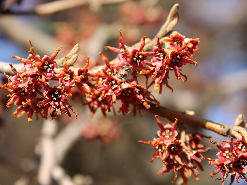
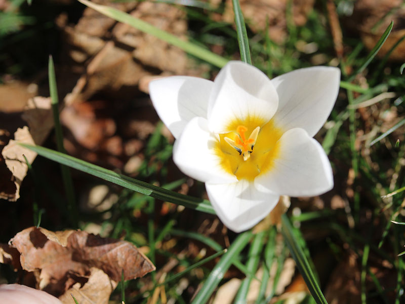
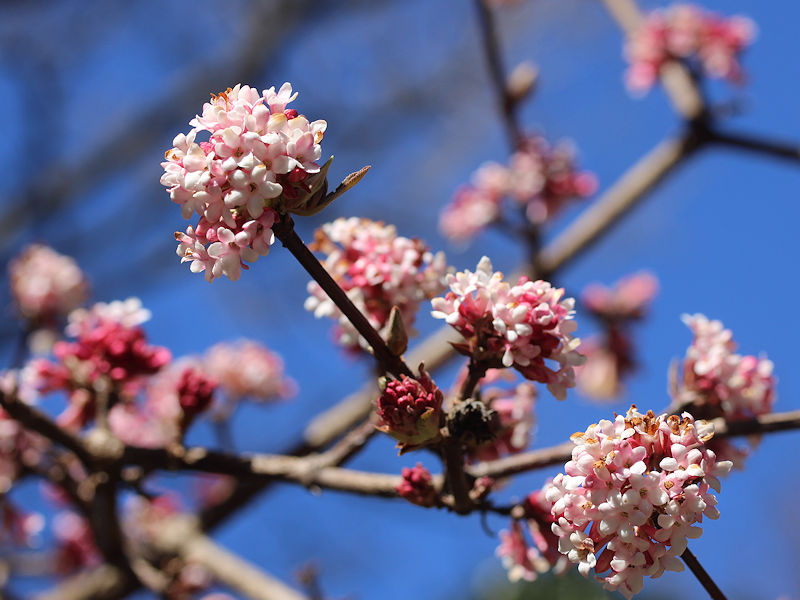
On account of what amounted to an autumn that extended through most of February, blossoms are out early at the New York Botanical Garden. Inside the Enid Haupt Conservatory, The Orchid Show: Florals in Fashion is ongoing.


-
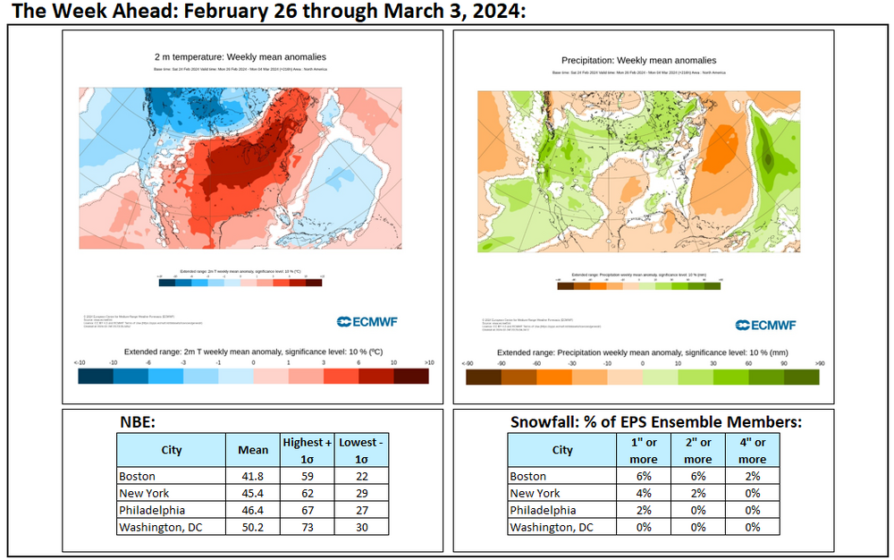
Week ahead numbers:
-
It will be a close call, even as February 29th is cooler than modeled a few days ago. If the warmth overperforms next week, February could have a 40-degree mean temperature.
-
Tomorrow will be another chilly day. However, the cold will rapidly depart from the region by Monday. Afterward, temperatures will quickly rebound. Afterward, temperatures will remain generally above normal through the remainder of February. The potential exists for the closing days of February to wind up much warmer than normal. Little or no additional snowfall is likely in the New York City or Philadelphia areas through the remainder of February. March will likely begin with generally unseasonable warmth through the first 7-10 days of the month. No significant snowfall appears likely in the northern Middle Atlantic region during that time. Overall, March will likely be warmer than normal. The ENSO Region 1+2 anomaly was +1.1°C and the Region 3.4 anomaly was +1.5°C for the week centered around February 14. For the past six weeks, the ENSO Region 1+2 anomaly has averaged +0.95°C and the ENSO Region 3.4 anomaly has averaged +1.72°C. A basinwide El Niño event is ongoing. The ongoing El Niño event will continue to fade during March. Neutral conditions could develop during the spring. The SOI was +2.02 today. The preliminary Arctic Oscillation (AO) was +1.744 today. On February 22 the MJO was in Phase 5 at an amplitude of 0.343 (RMM). The February 21-adjusted amplitude was 0.126 (RMM). Based on sensitivity analysis applied to the latest guidance, there is an implied near 100% probability that New York City will have a warmer than normal February (1991-2020 normal). February will likely finish with a mean temperature near 39.9° (4.0° above normal). Winter 2023-2024 is on course to finish with a seasonal mean temperature of 40.4°-40.7°. That would rank the current winter among the ten warmest on record in New York City. It would also mark the second time when two consecutive winters have ranked among the top ten in terms of warmth. Winters 2015-2016 and 2016-2017 are currently the only two such winters to rank among the ten warmest on record. Winters 2022-2023 and 2023-2024 will become the first time on record that New York City has seen two consecutive winters with 40.0° or above mean temperatures. Since 1869, there have been six winters with a mean temperature of 40.0° or above. Five have occurred since 2000.
-
It's probably not too surprising. The weeklies have little or no skill beyond two weeks.
-
1996-97 and 1997-98. 3 out of 5 winters when 1994-95 is included.
-
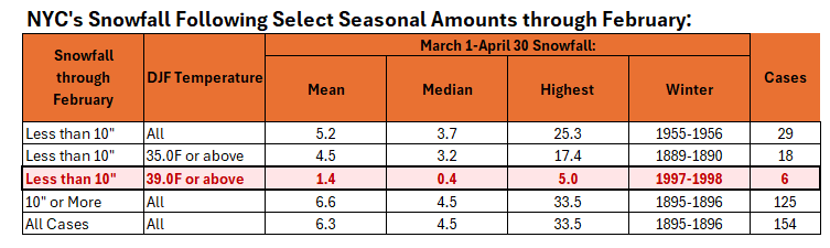
With little or no additional snowfall likely in New York City through the remainder of February, the probability that Central Park will see its first case of two consecutive winters with less than 10.0" seasonal snowfall has increased. Below are the numbers for select snowfall amounts through February. The highlighted row indicates where Winter 2023-2024 will very likely stand when February concludes.
-
This weekend will feature a brief push of cooler air into the region. The cold shot will be shortlived. Afterward, temperatures will quickly rebound. Afterward, temperatures will remain generally above normal through the remainder of February. The potential exists for the closing days of February to wind up much warmer than normal. Little or no additional snowfall is likely in the New York City or Philadelphia areas through the remainder of February. March will likely begin with generally unseasonable warmth through the first 7-10 days of the month. No significant snowfall appears likely in the northern Middle Atlantic region during that time. The ENSO Region 1+2 anomaly was +1.1°C and the Region 3.4 anomaly was +1.5°C for the week centered around February 14. For the past six weeks, the ENSO Region 1+2 anomaly has averaged +0.95°C and the ENSO Region 3.4 anomaly has averaged +1.72°C. A basinwide El Niño event is ongoing. The ongoing El Niño event will continue to fade. The SOI was -3.75 today. The preliminary Arctic Oscillation (AO) was +2.171 today. On February 21 the MJO was in Phase 5 at an amplitude of 0.126 (RMM). The February 20-adjusted amplitude was 0.432 (RMM). Based on sensitivity analysis applied to the latest guidance, there is an implied near 100% probability that New York City will have a warmer than normal February (1991-2020 normal). February will likely finish with a mean temperature near 39.9° (4.0° above normal). Winter 2023-2024 is on course to finish with a seasonal mean temperature of 40.5°-40.7°. That would rank the current winter among the ten warmest on record in New York City. It would also mark the second time when two consecutive winters have ranked among the top ten in terms of warmth. Winters 2015-2016 and 2016-2017 are currently the only two such winters to rank among the ten warmest on record. It would also be the first time on record that New York City has seen two consecutive winters with 40.0° or above mean temperatures. Since 1869, there have been six winters with a mean temperature of 40.0° or above. Five have occurred since 2000.
-
A lot more warming.
-
The real trigger would sufficient evaporation of the oceans. That’s currently not likely. A good paper: https://www.aanda.org/articles/aa/full_html/2023/12/aa46936-23/aa46936-23.html
-
CO2 reacts with water to form carbonic acid. As carbonic acid concentrations rise, oceans become more acidic, as is currently occurring.
-
On humanity's present course, the risk of an anoxic ocean event will increase, especially later this century and beyond.
-
Ocean acidification is also an growing issue.

-
A milder pattern is now in place. Aside from a brief push of cooler air during the coming weekend, temperatures should remain generally above normal through the remainder of February. The potential exists for the closing days of February to wind up much warmer than normal. Little or no additional snowfall is likely in the New York City or Philadelphia areas through the remainder of February. March will likely begin with generally unseasonable warmth through the first 7-10 days of the month. No significant snowfall appears likely in the northern Middle Atlantic region during that time. The ENSO Region 1+2 anomaly was +1.1°C and the Region 3.4 anomaly was +1.5°C for the week centered around February 14. For the past six weeks, the ENSO Region 1+2 anomaly has averaged +0.95°C and the ENSO Region 3.4 anomaly has averaged +1.72°C. A basinwide El Niño event is ongoing. The ongoing El Niño event will continue to fade. The SOI was -0.96 today. The preliminary Arctic Oscillation (AO) was +2.568 today. On February 20 the MJO was in Phase 8 at an amplitude of 0.432 (RMM). The February 19-adjusted amplitude was 0.808 (RMM). Based on sensitivity analysis applied to the latest guidance, there is an implied near 100% probability that New York City will have a warmer than normal February (1991-2020 normal). February will likely finish with a mean temperature near 39.9° (4.0° above normal). Winter 2023-2024 is on course to finish with a seasonal mean temperature of 40.4°-40.7°. That would rank the current winter among the ten warmest on record in New York City. It would also mark the second time when two consecutive winters have ranked among the top ten in terms of warmth. Winters 2015-2016 and 2016-2017 are currently the only two such winters to rank among the ten warmest on record. It would also be the first time on record that New York City has seen two consecutive winters with 40.0° or above mean temperatures. Since 1869, there have been six winters with a mean temperature of 40.0° or above. Five have occurred since 2000.
-
These are all good points. Of course, we'll have to see how the MJO actually progresses.
-
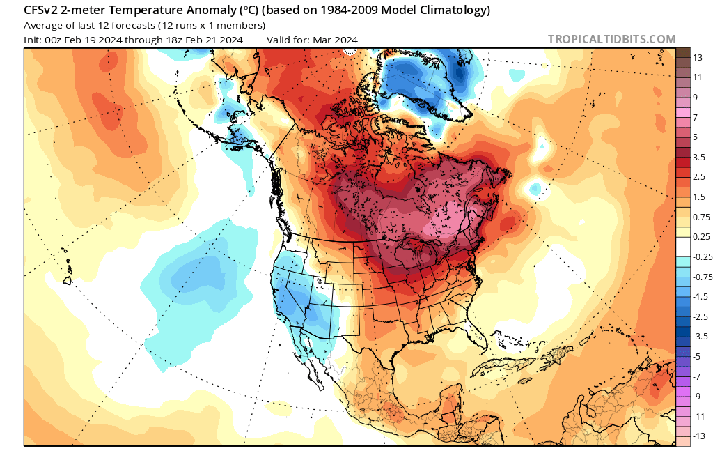
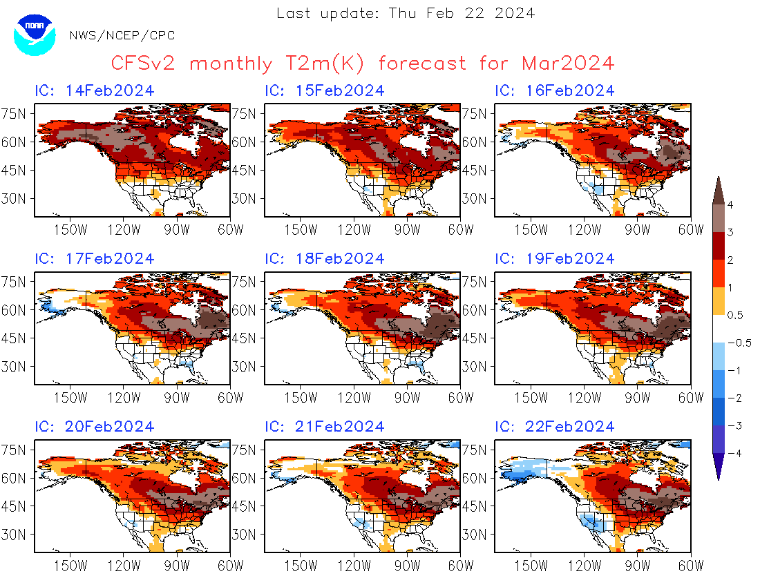
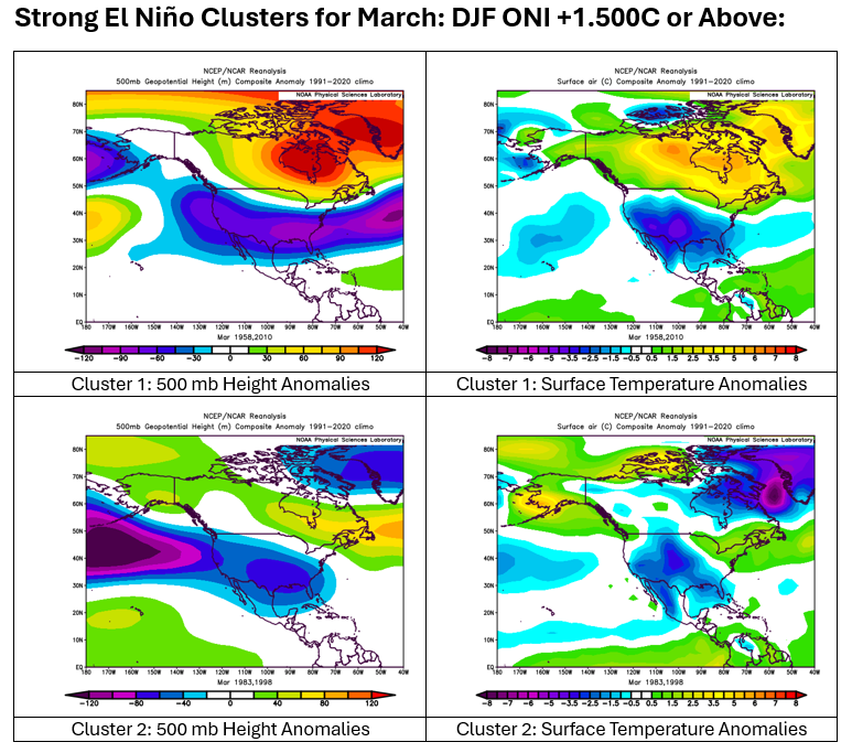
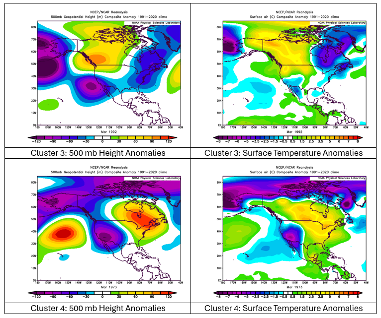
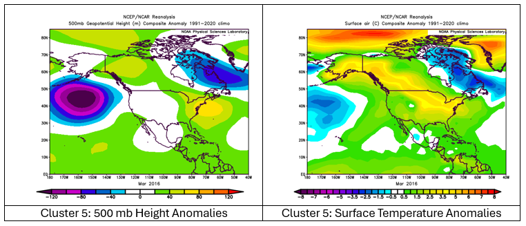
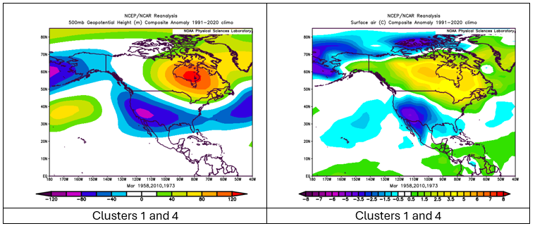
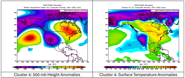
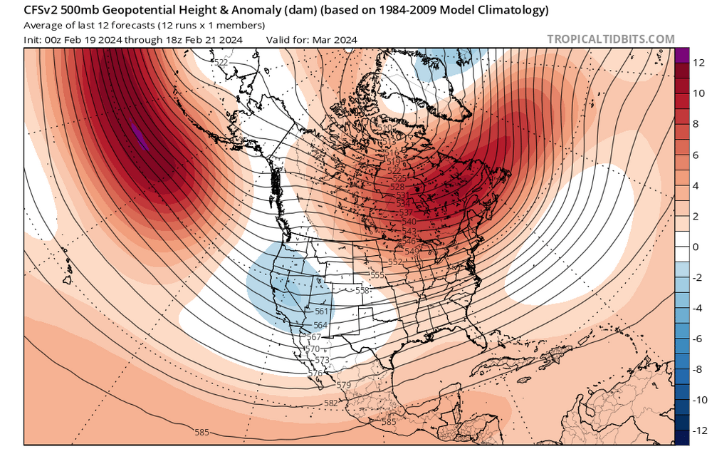
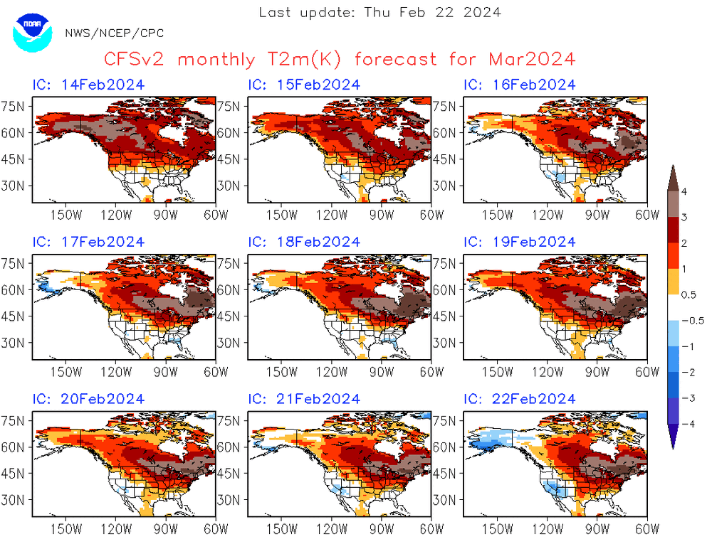
The CFSv2 is now moving into its skillful range. Its March outlook has shifted toward Cluster 4 of the strong ENSO cases provided previously. Cluster 4 is the PDO- case from 1973. Previously, the CFSv2 had favored a warmer version of Cluster 1, which had warmth across the northern tier of the CONUS. CFSv2 500 mb Forecast: CFSv2 Temperature Forecast: Evolution of CFSv2 Forecasts: Key Takeaways: A warmer than normal March continues to be favored in the Northeast, including the Middle Atlantic and southern New England regions (majority of ENSO clusters and evolving CFSv2 guidance) Based on strong ENSO climatology, the March 11-24 period might offer the remaining window of opportunity for some cold and/or snow. The latest ECMWF weekly guidance has the coldest anomalies relative to normal in the closing 2 weeks of the month, but the weeklies lack skill at that timeframe. Until one is closer to the forecast period and there is both skill and consensus on the guidance, it makes sense to defer to climatology. The potential stratospheric warming event could be a "final warming" event. Such events typically do not have the same response as other stratospheric warming events. ENSO Cluster 4 (PDO-) favors below normal snowfall in the Northeast. Based on the latest guidance, the probability that Central Park could fail to reach 10" snow for a record second consecutive winter has increased.

-
Although a cooler period developed on February 13th, it ended today. I had expected that it could extend into the first week of March. In addition, New York City saw no readings with lows in the teens (the coldest weather was warmer than I had expected). Central Park saw a light and moderate snowfall. JFK Airport saw a moderate and significant snowfall. LaGuardia Airport experienced two moderate snowfalls. The cooler period ended largely in line with strong ENSO climatology in February, which often has seen the closing 7-10 days wind up warmer to much warmer than normal. The latest ECMWF weeklies see warmer than normal conditions running into at least the second week of March. Strong ENSO climatology has typically seen a cool-down before mid-March that continues just past the Spring Equinox. Afterward, it turns warmer. Given lack of model skill at such distant timeframes, the outcome beyond the first week of March remains speculative. Despite a possible stratospheric warming event, it's entirely plausible that the Polar Vortex could remain over Eurasia and cooler weather could be relatively short-lived. All in all, the odds may somewhat lean toward a warmer than normal March.
-
A milder pattern is now developing. Aside from a brief push of cooler air during the coming weekend, temperatures should remain generally above normal through the remainder of February. The potential exists for the closing days of February to wind up much warmer than normal. Little or no additional snowfall is likely in the New York City or Philadelphia areas through the remainder of February. Overall, a very warm winter is nearing an end. As warm as the winter has been in the New York City area, it has been even warmer in the Great Lakes Region and Northern Plains. Fargo is on track to beat its old winter record by more than 4°. Moreover, Winter 2023-24 could be Fargo's first winter where two months saw the temperature fail to drop below 0°. Milwaukee, Minneapolis, and Grand Forks are also on track to record their warmest winter on record. All the above sites have climate records that extend back into the 19th century. The ENSO Region 1+2 anomaly was +1.1°C and the Region 3.4 anomaly was +1.5°C for the week centered around February 14. For the past six weeks, the ENSO Region 1+2 anomaly has averaged +0.95°C and the ENSO Region 3.4 anomaly has averaged +1.72°C. A basinwide El Niño event is ongoing. The ongoing El Niño event will continue to fade. The SOI was +6.10 today. The preliminary Arctic Oscillation (AO) was +2.157 today. On February 19 the MJO was in Phase 8 at an amplitude of 0.808 (RMM). The February 18-adjusted amplitude was 0.869 (RMM). Based on sensitivity analysis applied to the latest guidance, there is an implied near 100% probability that New York City will have a warmer than normal February (1991-2020 normal). February will likely finish with a mean temperature near 39.8° (3.9° above normal). Winter 2023-2024 is on course to finish with a seasonal mean temperature of 40.3°-40.6°. That would rank the current winter among the ten warmest on record in New York City. It would also mark the second time when two consecutive winters have ranked among the top ten in terms of warmth. Winters 2015-2016 and 2016-2017 are currently the only two such winters to rank among the ten warmest on record. It would also be the first time on record that New York City has seen two consecutive winters with 40.0° or above mean temperatures. Since 1869, there have been six winters with a mean temperature of 40.0° or above. Five have occurred since 2000.
-
After a cold start, the temperature rose into the upper 30s to around 40° today. Even milder air will begin to overspread the region tomorrow. Afterward, aside from a brief push of cooler air next weekend, temperatures should remain generally above normal once the milder pattern develops. The potential exists for the closing days of February to wind up much warmer than normal. Little or no additional snowfall is likely in the New York City or Philadelphia areas through the remainder of February. The ENSO Region 1+2 anomaly was +1.1°C and the Region 3.4 anomaly was +1.5°C for the week centered around February 14. For the past six weeks, the ENSO Region 1+2 anomaly has averaged +0.95°C and the ENSO Region 3.4 anomaly has averaged +1.72°C. A basinwide El Niño event is ongoing. The ongoing El Niño event will continue to fade. The SOI was +3.27 today. The preliminary Arctic Oscillation (AO) was +1.871 today. On February 18 the MJO was in Phase 7 at an amplitude of 0.869 (RMM). The February 17-adjusted amplitude was 1.056 (RMM). Based on sensitivity analysis applied to the latest guidance, there is an implied 99% probability that New York City will have a warmer than normal February (1991-2020 normal). February will likely finish with a mean temperature near 39.8° (3.9° above normal). Winter 2023-2024 is on course to finish with a seasonal mean temperature of 40.4°-40.8°. That would rank the current winter among the ten warmest on record in New York City. It would also mark the second time when two consecutive winters have ranked among the top ten in terms of warmth. Winters 2015-2016 and 2016-2017 are currently the only two such winters to rank among the ten warmest on record. It would also be the first time on record that New York City has seen two consecutive winters with 40.0° or above mean temperatures. Since 1869, there have been six winters with a mean temperature of 40.0° or above. Five have occurred since 2000.
-
No. 17 is the low so far.
-
I agree. I believe both factors played an important role in shaping the outcome for Winter 2023-24. They likely made the difference in what will probably be the CONUS's warmest winter on record. We'll probably see more such outcomes when it comes to details, as the warmer oceans and more frequent/widespread marine heatwaves distort the patterns from what might more typically occur during various ENSO cycles. In my case, I wanted to illustrate how one's going against the guidance to get a basic assumption incorrect could have a large impact on forecast verification.