donsutherland1
-
Posts
24,194 -
Joined
Content Type
Profiles
Blogs
Forums
American Weather
Media Demo
Store
Gallery
Everything posted by donsutherland1
-
I don't think he has changed his thinking. A cooler period after mid-month remains very plausible. The question concerns whether it will be sufficiently cold to allow for Philadelphia to New York City to pick up meaningful snowfall. Up to mid-month, I don't think such snowfall is likely for those cities. Afterward, we'll have to see how things evolve. If the deep pool of cold air currently over Eurasia fails to advance into North America, the odds of such a snowstorm are lower than would otherwise be the case. Unfortunately, even as the sample size is small, such snowfall has not occurred past mid-March for winters that were as warm as the most recent one.
-
It was. My point is that there was a large pool of cold air—actually frigid air—to be tapped. Through mid-March that does not appear likely to be the case.
-
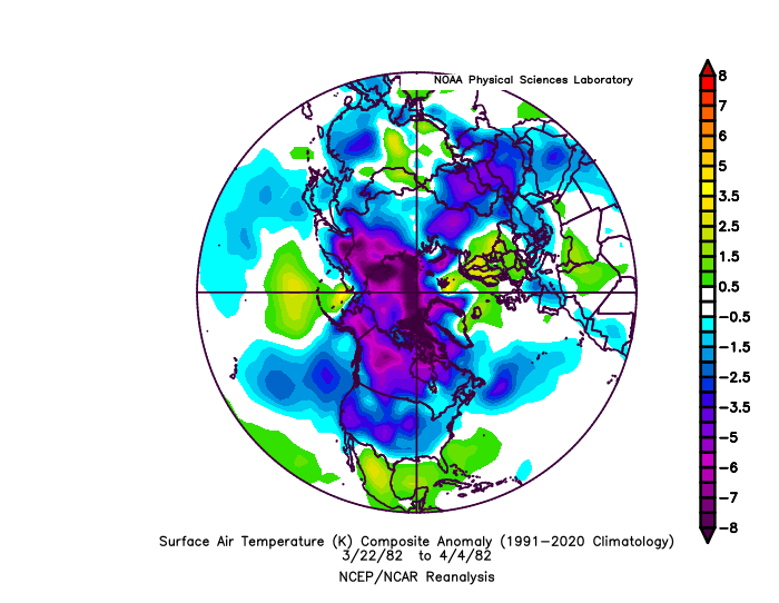
Beyond mid-month, we'll see if the promised cooler (but not necessarily very cold) pattern can produce any snowfall for the NYC area. Before then, central/upstate New York and central/northern New England will probably be favored for meaningful snowfall opportunities. As for 1982, here's how things looked for the two-week period preceding the blizzard: Here's the most recent two weeks for which data is available: It remains to be seen how much, if any of that pool of cold air will spill into North America and how long the process would take. Modified Pacific air will likely dominate for the next week or two, so even if the forecast trough develops, the cold likely won't be all too impressive. Not speaking for others, my thinking is that NYC and Philadelphia will probably see little or no snowfall through mid-month. During that time, cold shots will likely be fair short in duration 1-3 days and not especially impressive. Although NYC (Central Park) probably has not seen its last freeze, it has likely seen its last sub-20° low temperature and last sub-freezing day until next winter.
-
I'm not aware of any other stations in Manhattan that regularly measure snowfall. The downtown heliport does not measure snow.
-
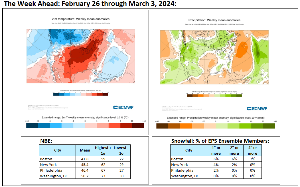
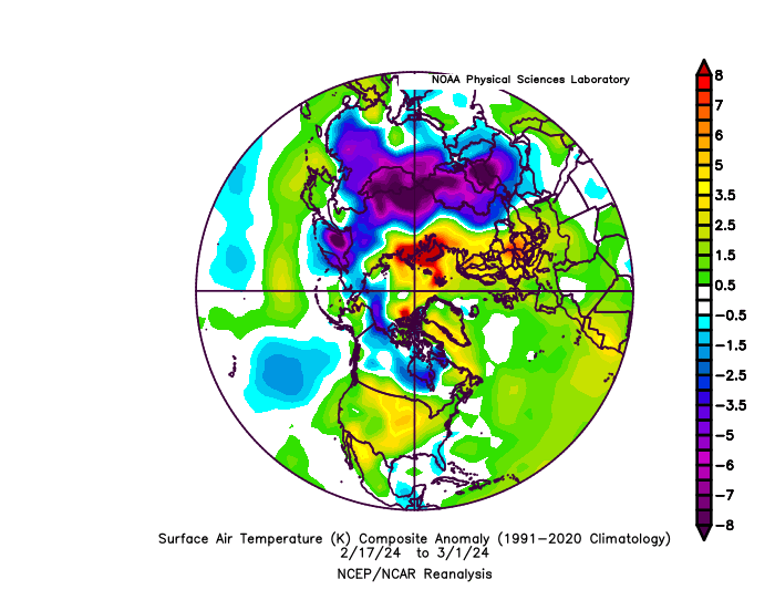
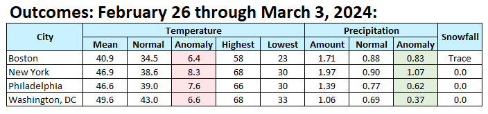
The February 26-March 3, 2024 period was warm and wet from Washington, DC to Boston.
-
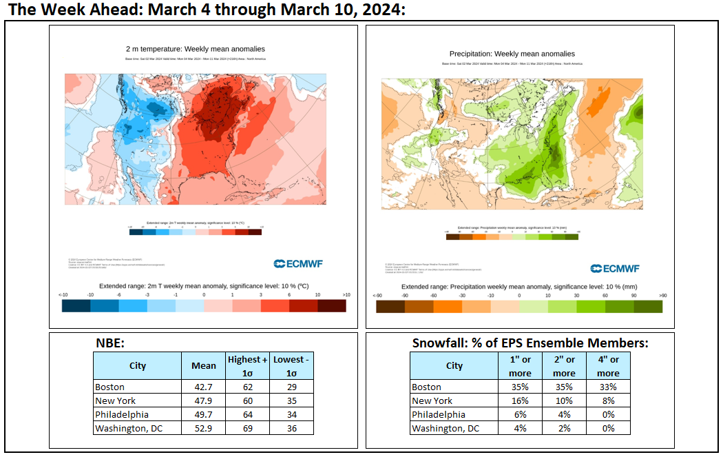
In response to brilliant sunshine, the mercury soared to near record and record levels across the region today. Daily records included: Bridgeport: 65° (old record: 58°, 1967 and 2004) Hartford: 67° (old record: 63°, 1991 and 2020) New Haven: 68° (old record: 58°, 1967) New York City-Central Park: 68° (old record: 65°, 1991) New York City-JFK Airport: 68° (old record: 63°, 1991) New York City-LaGuardia Airport: 68° (old record: 65°, 1967) Newark: 70° (old record: 66°, 1991) Providence: 63° (tied record set in 1991) In the North Central United States, the warmest winter on record, was followed by additional record warmth. Minneapolis reached 72°, its earliest 70° or above temperature on record. Rockford hit a daily record 75°. An extended period of warmer to much warmer than normal weather is now underway. March will likely see generally unseasonable warmth through the first 7-10 days of the month. The generally mild conditions could persist through mid-month. However, rainfall totals will likely be above to much above normal. No significant snowfall appears likely in the northern Middle Atlantic region through at least March 10th. The probability of an unprecedented second consecutive winter with less than 10" seasonal snowfall in New York City has increased. The ENSO Region 1+2 anomaly was +0.7°C and the Region 3.4 anomaly was +1.5°C for the week centered around February 21. For the past six weeks, the ENSO Region 1+2 anomaly has averaged +0.92°C and the ENSO Region 3.4 anomaly has averaged +1.65°C. A basinwide El Niño event is ongoing. The ongoing El Niño event will continue to fade during March. Neutral conditions could develop during the spring. The SOI was +3.11 today. The preliminary Arctic Oscillation (AO) was -0.112 today.
-
The temperature in New York City has reached 67F (19.4C). That breaks the daily record of 65F (18.3C) from 1991.
-
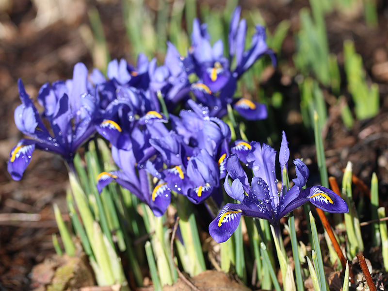
With each passing day, more and more flowers are bursting in bloom at the New York Botanical Garden. While the ECMWF weeklies pick up the pieces of a shattered late February to mid-March forecast, cold analogs from 1958 and 2018 lie in the trash can, Punxsutawney Phil is sipping champagne and admiring the spring colors outside his burrow to celebrate a verified long-range forecast. From the New York Botanical Garden:


-
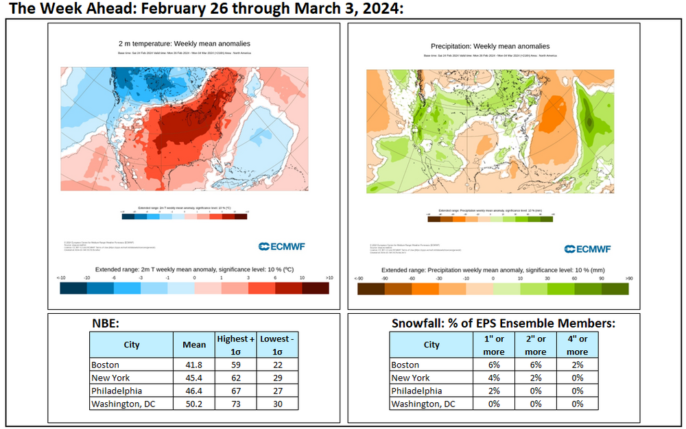
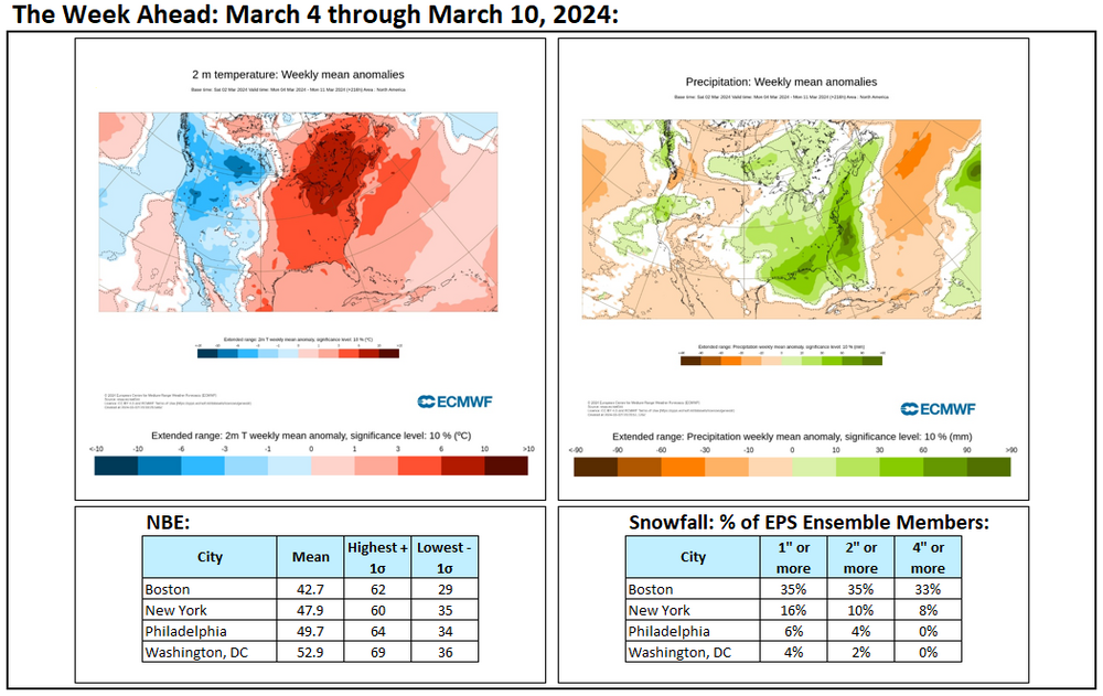
Week ahead numbers: A very mild and wet week lies ahead.
-
Yes. This has been an issue. It’s unfortunate. The same applies to the foliage around the ASOS.
-
Periods of rain will continue through the night. The rain will depart from the region from west to east tomorrow. Rainfall will total a general 0.50"-1.50". Afterward, the sun could break out and the temperature will likely soar into the upper 50s and lower 60s in the New York City area. Middle 60s are likely from Washington, DC into southern New Jersey. An extended period of warmer to much warmer than normal weather is now underway. March will likely see generally unseasonable warmth through the first 7-10 days of the month. The generally mild conditions could persist through mid-month. As has often been the case in recent months, the most impressive warmth in absolute temperatures and relative to normal will likely occur north and west of New York City. New York City will likely finish the first week of the month with an anomaly near 10° above normal despite frequent wet weather. No significant snowfall appears likely in the northern Middle Atlantic region through at least March 10th. The probability of an unprecedented second consecutive winter with less than 10" seasonal snowfall in New York City has increased. The ENSO Region 1+2 anomaly was +0.7°C and the Region 3.4 anomaly was +1.5°C for the week centered around February 21. For the past six weeks, the ENSO Region 1+2 anomaly has averaged +0.92°C and the ENSO Region 3.4 anomaly has averaged +1.65°C. A basinwide El Niño event is ongoing. The ongoing El Niño event will continue to fade during March. Neutral conditions could develop during the spring. The SOI was +4.02 today. The preliminary Arctic Oscillation (AO) was +0.091 today.
-
Based on all the snowfall seasons to date, it's currently about one-in-three.
-
The GFS figure is from 10:1 vendor maps, not the NOAA. Soundings show sleet during the height of the precipitation in NYC with a warm layer at 850 mb +/- 25 or so mb. Just as other model output is low skill at the timeframe involved, the same applies to the soundings. However, the other guidance is warmer. Until there is consensus toward the GFS idea, I'm reluctant to embrace the GFS's outlier solution. The temperature chart merely illustrates the range for past storms with specified temperatures. The point is that typically storms with above freezing temperatures tend to have lower snowfall amounts. Only a few have been moderate or larger. North and west of NYC, things would be more favorable. But we'll have to see where things stand in a few days when model skill begins to improve and when the synoptic picture itself becomes clearer. It's premature for the posting of operational model maps showing a snowy outcome for NYC. Indeed, just one member of the GEFS and not a single EPS member shows anything like the GFS did. There are many arguments for caution, not to mention that such events have been infrequent for NYC following winters as warm as the one the region just had. In sum, the base case is against the 12z GFS's significant snowfall for NYC (not necessarily well north and west of it). Something lighter is currently in play for NYC, JFK, and LGA. Until much changes (synoptic details, model/ensemble support, deeper cold farther south, etc.), there's little reason to depart from the base case.
-
The heaviest precipitation is finished by 204 hours, even as it's cold enough for snow. Hours 204-210 might be sufficient for 1"-2", if the model output is right. But at this point in time, it's speculative given the lack of other support and timeframe involved. My point is that the 7.8" total is unlikely without dramatic changes.
-
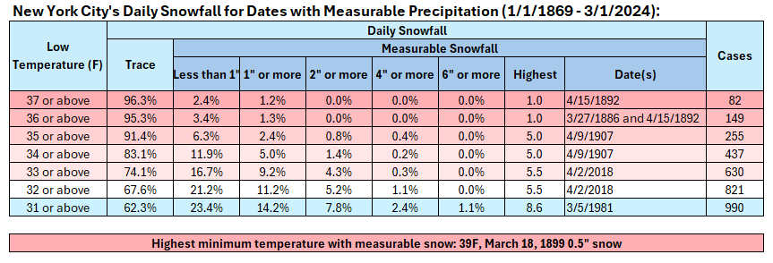
Some points about the 12z GFS's Day 8-9 Storm: 1. The GFS is in a timeframe where skill is low 2. The GFS lacks support from other global models and the ensembles 3. The GFS's soundings show readings remaining above freezing throughout the storm New York City's Above Freezing Snowfalls: In short, unless there is more than a marginal air mass and strong support from the other guidance, one should be skeptical of the snowfall amount (7.8") shown on the GFS. Ratios for any snow would be far lower than 10:1.
-
I agree. The trees have undercut the summer high temperatures. The trend in Central Park's summer high temperatures has diverged from those at nearby locations, further illustrating the cooling impact of the trees.
-
For New York City:
-
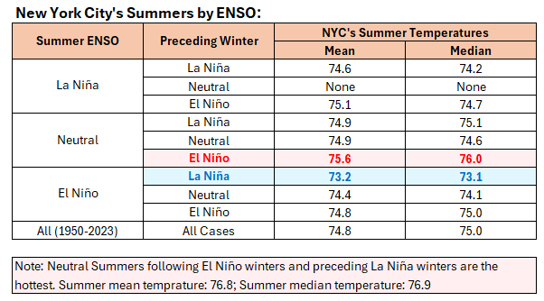
That’s if the summer has a neutral ENSO. The CFSv2 is quite aggressive in bringing La Niña for summer.
-
-
An extended period of warmer to much warmer than normal weather is getting underway. March will likely see generally unseasonable warmth through the first 7-10 days of the month. The generally mild conditions could persist through mid-month. As has often been the case in recent months, the most impressive warmth in absolute temperatures and relative to normal will likely occur north and west of New York City. New York City will likely finish the first week of the month with an anomaly near 10° above normal despite frequent wet weather. No significant snowfall appears likely in the northern Middle Atlantic region through at least March 10th. The probability of an unprecedented second consecutive winter with less than 10" seasonal snowfall in New York City has increased. The ENSO Region 1+2 anomaly was +0.7°C and the Region 3.4 anomaly was +1.5°C for the week centered around February 21. For the past six weeks, the ENSO Region 1+2 anomaly has averaged +0.92°C and the ENSO Region 3.4 anomaly has averaged +1.65°C. A basinwide El Niño event is ongoing. The ongoing El Niño event will continue to fade during March. Neutral conditions could develop during the spring. The SOI was +0.53 today. The preliminary Arctic Oscillation (AO) was +0.920 today.
-
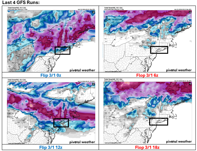
An example of poor run-to-run continuity: Snowfall Forecasts
-
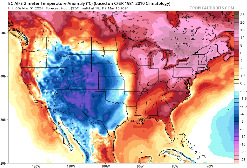
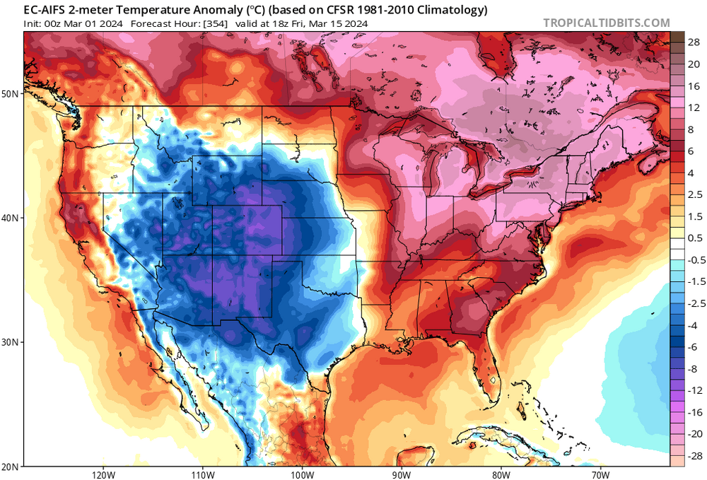
FYI, Tropical Tidbits now posts the ECMWF's AI forecasts. It's 3/15 map screams "Beware of the Ides of March!" It's posted here for purposes of illustration only.
-
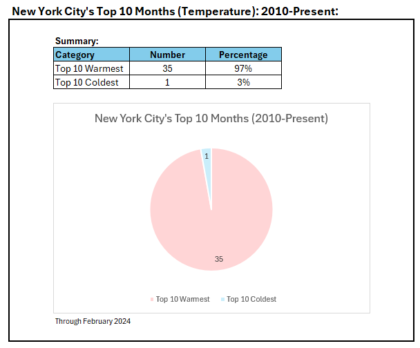
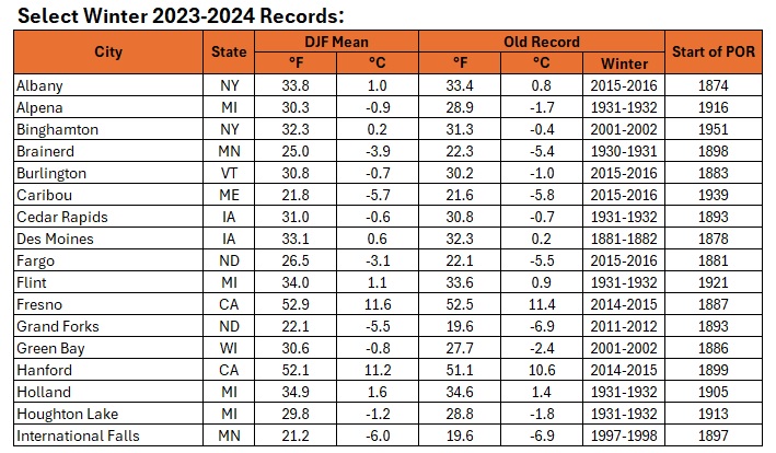
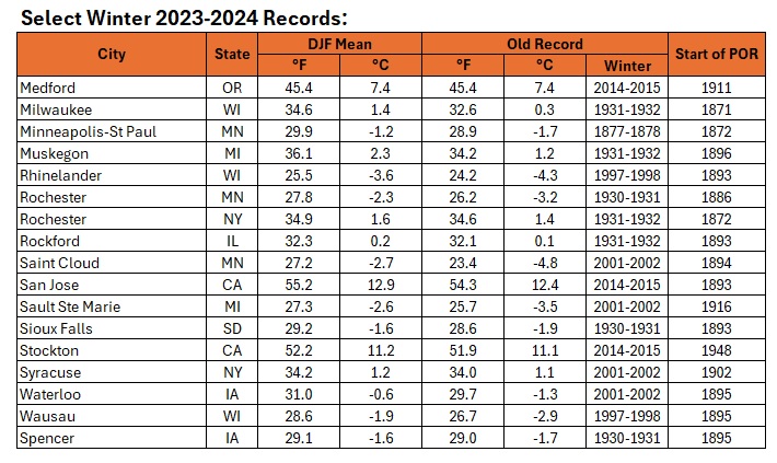
Some of the seasonal records were demolished.
-
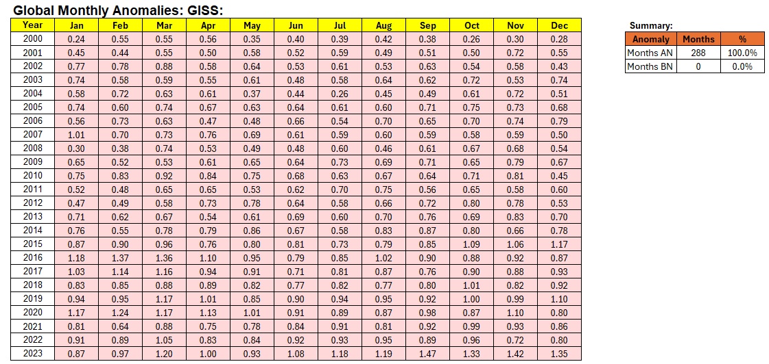
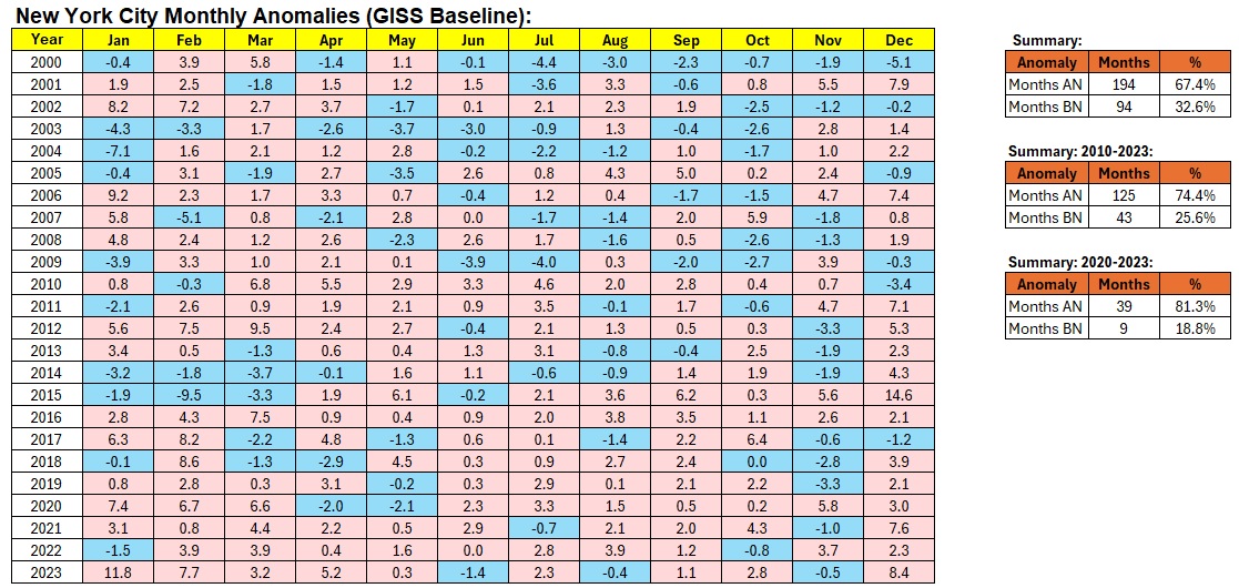
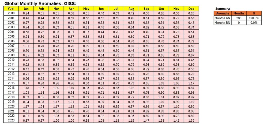
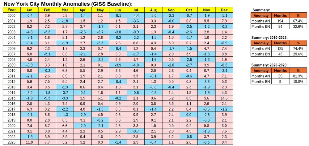
With shrinking areas of cold globally, it is little surprise that warmer months are becoming more frequent even on a local basis. Below are monthly global GISS anomalies (2000-2023) and New York City's anomalies using the GISS baseline:
-
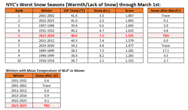
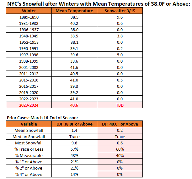
Winter futility through March 1st. Winter 2023-2024 would rank 5th. Snowfall following winters with mean temperatures of 40.0° or above in New York City has been low for the remainder of snow season.