donsutherland1
-
Posts
24,194 -
Joined
Content Type
Profiles
Blogs
Forums
American Weather
Media Demo
Store
Gallery
Everything posted by donsutherland1
-
Looking ahead, here are the NYC daily temperature averages from strong El Niño winters:
-
It would take more than 5 more years to reach that mark: 2,572 days (March 1, 1949 through March 15, 1956).
-
I agree. The numbers out there appear realistic and in line with one another.
-
I expect that it will start getting milder after the 20th. It will probably be drier than normal. Apparently, strong ENSO climatology proved superior to the prior extended range guidance, as the warmup is consistent with that climatology.
-
The NWS had a storm report that showed 8.7" there.
-
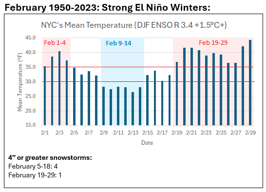
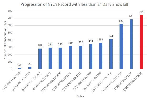
Parts of the region saw their biggest snowstorm in nearly two years. Central Park's 3.2" snowfall brought an end to the record 744-day streak without 2" or more daily snowfall. A general 3"-6" of snow fell in New York City. Outside the City, 6"-10" amounts were common with numerous 8"-10" amounts in Rockland County. Orange County saw a number of 12" or above amounts. In the wake of the storm, it will turn colder for a time. This will not be an especially cold pattern, but it will be noticeably colder than the pattern that defined the first 10 days of the month. It also won't be a long-duration pattern, as the closing days of February could turn unseasonably mild. The ENSO Region 1+2 anomaly was +1.2°C and the Region 3.4 anomaly was +1.7°C for the week centered around February 7. For the past six weeks, the ENSO Region 1+2 anomaly has averaged +0.93°C and the ENSO Region 3.4 anomaly has averaged +1.62°C. A basinwide El Niño event is ongoing. The ongoing El Niño event will continue to fade through much of February. The SOI was not available today. The preliminary Arctic Oscillation (AO) was -1.716 today. On February 11 the MJO was in Phase 7 at an amplitude of 1.892 (RMM). The February 10-adjusted amplitude was 1.957 (RMM). Based on sensitivity analysis applied to the latest guidance, there is an implied 80% probability that New York City will have a warmer than normal February (1991-2020 normal). February will likely finish with a mean temperature near 38.1° (2.2° above normal). Winter 2023-2024 is on course to finish with a seasonal mean temperature of 39.7°-40.4°. That would rank the current winter among the ten warmest on record in New York City. It would also mark the second time when two consecutive winters have ranked among the top ten in terms of warmth. Winters 2015-2016 and 2016-2017 are currently the only two such winters to rank among the ten warmest on record. Should Winter 2023-2024 finish with a mean temperature of 40.0° or above, that would be the first time on record that New York City has seen two consecutive winters with such warmth.
-
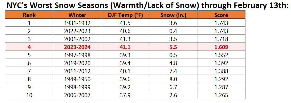
Winter futility rankings after today's snowfall. Winter 2023-2024 tumbles to 4th worst through February 13th.
-
JFK Airport: 6.5:1 LaGuardia Airport: 5.2:1
-
4.9" total snowfall.
-
LaGuardia was 3.3" and Central Park was 3.2". They are essentially the same. I don't have an issue with the measurement for this storm.
-
3.2" at Central Park. Snow-to-liquid ratio: 4.2:1 The record streak without 2" or above daily snowfall ends at 744 days.
-
Short video from this morning: https://youtu.be/SGBwir1reyU?si=5Nqscs0ApHj4VGmu
-
Those figures are based on the daily minimum temperature. If the temperature stays above freezing through midnight, this storm would almost certainly rank among the highest on the list.
-
I have around 6", too. It's winding down.
-
2 SW Newtown, CT: 13.2"
-
Central Park's next measurement is at 1 pm. The 7 am figure was 1.2". Central Park should be at or over 4".
-
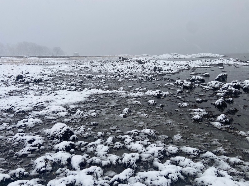
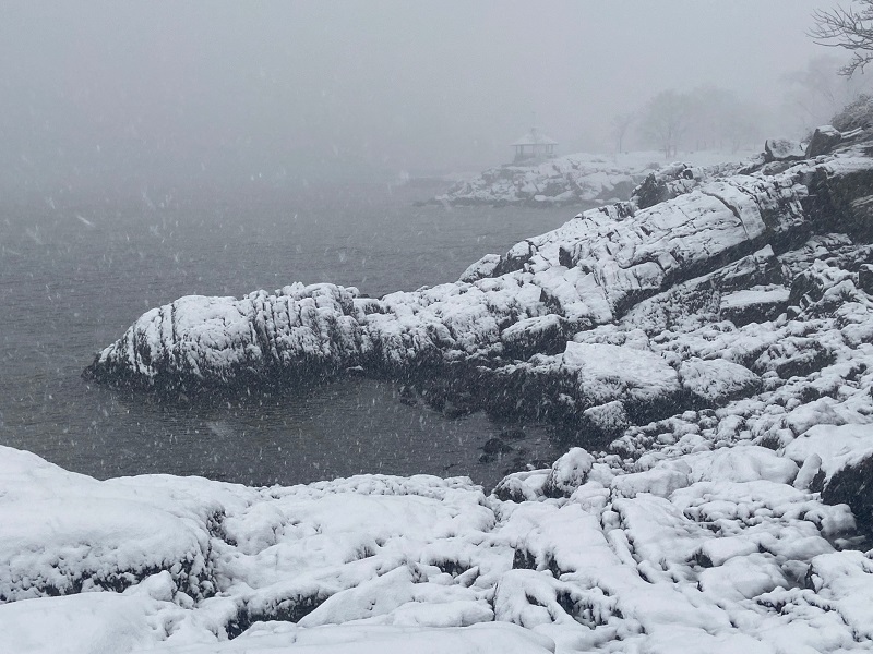
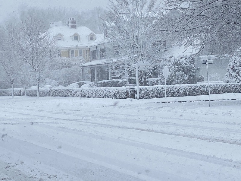
Larchmont, NY in southern Westchester County.
-
Three photos from this morning:
-
3 ESE Port Jervis, NY: 8.5"
-
The National Blend of Models badly overstated readings (estimating a low of 36). 33-34 seemed more reasonable, but given that we're already at 33 in NYC, it's possible to drop another degree or even two when the heavy snow arrives.
-
High snow report so far: 7.0" 2 SSW Middletown, NY. There are numerous 5"+ amounts in Orange County. There are no reports yet from Central Park and Newark where their record 744-day streaks without 2" or more daily snowfall will finally end today.
-
The NBE/NBM will wind up having been far too warm for the storm in NYC. It consistently showed a temperature of 36. It is currently 33.
-
Rain mixed with sleet has just commenced in Larchmont.
-
It did.
-
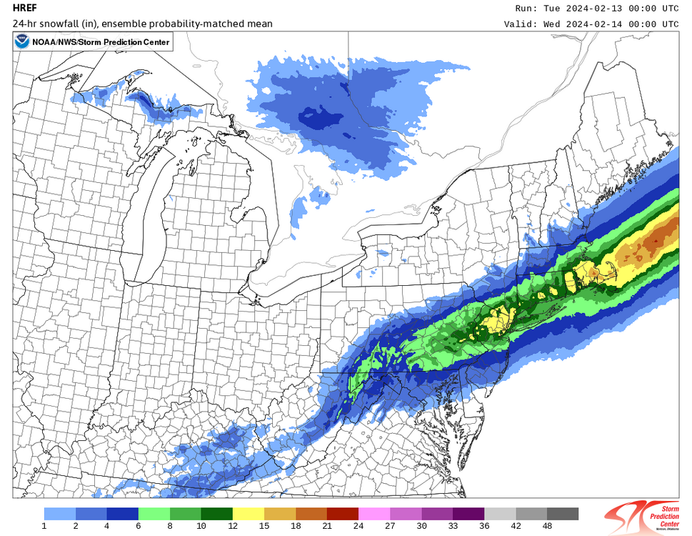
24-hour snowfall on the 2/13 0z HREF. As noted earlier, it is likely overdone, but illustrates where the heaviest snow could fall.