

donsutherland1
-
Posts
24,194 -
Joined
Content Type
Profiles
Blogs
Forums
American Weather
Media Demo
Store
Gallery
Everything posted by donsutherland1
-
JB is one of the three.
-
He's a PhD student at the University of Oklahoma and is really knowledgeable. His insights are consistently good. He puts accuracy ahead of making bold, splashy claims, the latter of which usually fail to materialize due to their nature as extreme outliers. IMO, he's a lot more credible than the 2-3 high profile accounts for whom seemingly all cold is epic, all snowstorms are legendary, and all events are extreme. Every cold pattern is not a repeat of 1985, 1994, or 2016. Every snowstorm is not a recurrence of the Blizzards of 1888 or 1978. Every 500 mb trough is not a recurrence of February 2010.
-
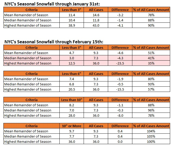
The clock continues to run when it comes to seasonal snowfall prospects. The below chart illustrates how things stood after January 31st and where things could stand after February 15th. That is historic data. Just as records can be broken, outcomes could diverge. But it makes sense to be grounded by the data until there is compelling evidence otherwise. On perhaps a more hopeful note, there have been 11 non-overlapping periods during February 15-March 15 (1950-2023) where the AO fell to -3 or below while the EPO and NAO were negative and the PNA was positive for two days or longer. For the time frame covered by those periods through 10 days following those periods the outcomes were as follows for New York City: Measurable snowfall: 82% of cases Daily snowfall of 1" or more: 73% of cases Daily snowfall of 4" or more: 55% of cases Daily snowfall of 6" or more: 45% of cases Worst period: March 9-22, 1970: Trace Best period: February 15-22, 2010 through March 4, 2010: 20.9" snowstorm (10"+ snowstorms also occurred in March 1958 and March 1960) It should also be noted that March 5-7, 1962 through March 17, 1962 was a "near miss" as a big cutoff low brought heavy snow to parts of the Middle Atlantic region while NYC saw only 0.2". February 13-14, 2024: In terms of the upcoming storm, the odds favor mainly or perhaps all rain for NYC. Any snow would likely be low- to very low-ratio wet snow given the forecast temperatures. Soundings will become important later as the event draws closer. February 15, 2024 and Beyond: A "battle" between historical outcomes and outcomes based on the forecast teleconnections could lie ahead. The historical outcomes would favor an increased likelihood of storms taking a more southerly route for a time resulting in perhaps higher snowfall in such cities as Baltimore and Washington than New York City or Boston. Then, as the block decays, storm tracks should shift northward. Whether that would happen in time for something notable remains to be seen. Overall Thinking: The cold period, which should run into at least the first week of March, will likely feature several light snow events and perhaps a moderate event (3"-4") for New York City. For now, until there is strong and sustained support on the guidance, historical experience with consideration for the forecast teleconnections is probably a reasonable approach.
-
The two-day figure was > 1 in 1,000 years. I don't have access to UCLA's older data, but the two-day figure was a record.
-
The final storm total at UCLA was 14.20". It was an unbelievable event.
-
A warming trend will get underway tomorrow The temperature could rise well into the 50s in New York City and into the 60s in Philadelphia and Washington, DC late in the week and early in the weekend. The generally mild conditions will likely continue into at least the second week of February with only brief interruptions. No Arctic air is likely to reach the area during this time. As a result, the first 10 days of February could wind up 5°-7° above normal in New York City. Potentially, New York City could wind up with a mean temperature of 40.0° or above during the February 1-10 period. Since 1869, there have been 9 prior cases. Five have occurred since 2000 and eight have occurred since 1990: 1952, 1990, 1991, 1999, 2005, 2008, 2012, 2016, and 2020. Seven of those nine years saw less than 10" snowfall for the remainder of the season following February 10th. Only one saw more than 20.0" (22.7", 2005). The least was the trace of snow that fell in 2020. The mean snowfall was 7.2" while the median snowfall was 6.0". In short, were the February 1-10 temperature to average 40.0° or above, that development could be a reinforcing signal for a below to much below normal snowfall season. The second week of February will likely see the evolution toward a sustained colder pattern begin late that week. Overall, February will likely wind up warmer than normal, even as the second half of the month could see a sustained period of colder weather. Single-digit cold is unlikely in New York City. During February, cases with warm ENSO Region 1+2 anomalies see such lows at 55% of frequency as cold ENSO Region 1+2 cases during El Niño winters. During the second half of February, just 17% of cases with a PDO- saw single-digit cold during El Niño winters. January saw a strongly negative PDO. The ENSO Region 1+2 anomaly was +1.0°C and the Region 3.4 anomaly was +1.8°C for the week centered around January 31. For the past six weeks, the ENSO Region 1+2 anomaly has averaged +0.87°C and the ENSO Region 3.4 anomaly has averaged +1.83°C. A basinwide El Niño event is ongoing. The ongoing El Niño event will continue to fade through much of February. The SOI was -41.69 today. The preliminary Arctic Oscillation (AO) was -1.040 today. On February 4 the MJO was in Phase 7 at an amplitude of 2.092 (RMM). The February 3-adjusted amplitude was 1.954 (RMM).
-
That was not a quality controlled number. The nearby station started reporting data on February 1, 2016, but didn’t report snowfall data. An earlier station in Hicksville stopped operating in 1938.
-
The highest figure for winter 2015-16 in the NYC region, including Long Island, was 42.2” at Middle Village 0.5 SW.
-
The record is 37 days (2011-12 and 2022-23).
-
The term was created by a team of MIT scientists in the 1990s. https://ny1.com/nyc/all-boroughs/ap-top-news/2024/02/01/a-look-at-atmospheric-rivers-the-long-bands-of-water-vapor-that-form-over-oceans-and-fuel-storms Their work was published in 1992: https://agupubs.onlinelibrary.wiley.com/doi/10.1029/92GL02916 They described the phenomenon as "atmospheric rivers" or "tropospheric rivers" due to the amount of water transported (often the equivalent of the Amazon River).
-
Yes, the same categories apply. The December 2023 atmospheric river was a category 5 one.
-
Atmospheric rivers are plumes of moisture that flow out of the tropics. They can occur outside of the Pacific. The East Coast had one in December. https://wapo.st/49mvHdP
-
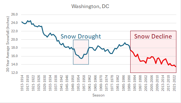
That's a key point. For purposes of illustration, below is Washington, DC's 30-year average seasonal snowfall. The red line denotes the timing where Washington, DC's mean winter temperature reached 37 degrees and then continued to rise due to ongoing warming.
-
A life-threatening atmospheric river continues to bring heavy rain and high wind to parts of southern California. Flash flooding, mudslides, and rock slides have been reported. Through 2 pm PST, Downtown Los Angeles has picked up 6.66" of rain. That is a new 2-day February record and the third highest 2-day figure on record. Records go back to 1877. Mild conditions prevailed under abundant sunshine in the Middle Atlantic and southern New England regions. However, the seeds of change are beginning to sprout. The Arctic Oscillation has gone negative (-0.369). That is one of the pieces that will fall into place leading to a large-scale pattern change near mid-month. Tomorrow will be fair and seasonably cool. Much warmer air will then push into the region afterward. The temperature could rise into the 50s in New York City and 60s south of Philadelphia late in the week. The generally mild conditions will likely continue into at least the second week of February with only brief interruptions. No Arctic air is likely to reach the area during this time. As a result, the first 10 days of February could wind up 5°-7° above normal in New York City. Potentially, New York City could wind up with a mean temperature of 40.0° or above during the February 1-10 period. Since 1869, there have been 9 prior cases. Five have occurred since 2000 and eight have occurred since 1990: 1952, 1990, 1991, 1999, 2005, 2008, 2012, 2016, and 2020. Seven of those nine years saw less than 10" snowfall for the remainder of the season following February 10th. Only one saw more than 20.0" (22.7", 2005). The least was the trace of snow that fell in 2020. The mean snowfall was 7.2" while the median snowfall was 6.0". In short, were the February 1-10 temperature to average 40.0° or above, that development could be a reinforcing signal for a below to much below normal snowfall season. The second week of February will likely see the evolution toward a sustained colder pattern begin late that week. Overall, February will likely wind up warmer than normal, even as the second half of the month could see a sustained period of colder weather. Single-digit cold is unlikely in New York City. During February, cases with warm ENSO Region 1+2 anomalies see such lows at 55% of frequency as cold ENSO Region 1+2 cases during El Niño winters. During the second half of February, just 17% of cases with a PDO- saw single-digit cold during El Niño winters. January saw a strongly negative PDO. The ENSO Region 1+2 anomaly was +1.0°C and the Region 3.4 anomaly was +1.8°C for the week centered around January 31. For the past six weeks, the ENSO Region 1+2 anomaly has averaged +0.87°C and the ENSO Region 3.4 anomaly has averaged +1.83°C. A basinwide El Niño event is ongoing. The ongoing El Niño event will continue to fade through much of February. The SOI was -36.41 today. The preliminary Arctic Oscillation (AO) was -0.369 today. On February 3 the MJO was in Phase 7 at an amplitude of 1.954 (RMM). The February 2-adjusted amplitude was 1.964 (RMM).
-
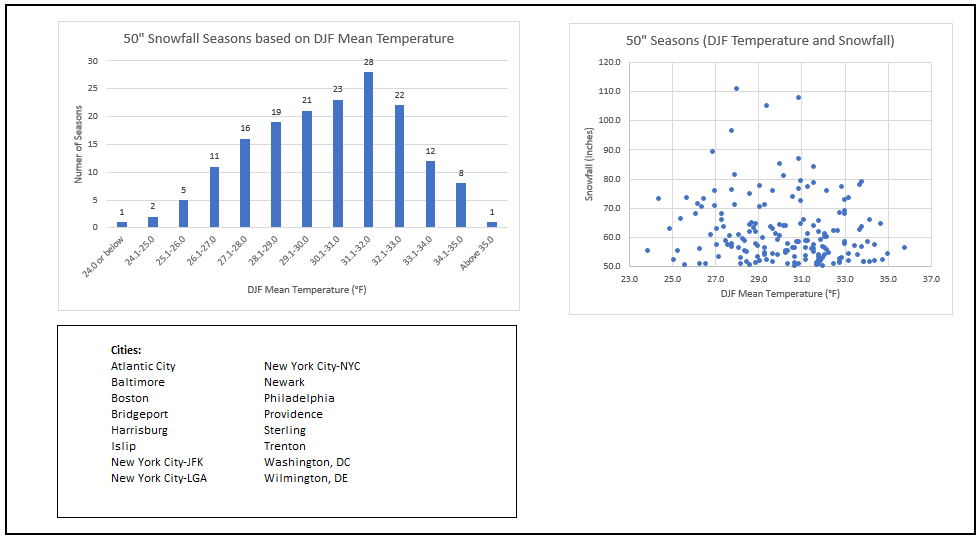
Since their respective periods of record began, here's the distribution of 50" or above snow seasons by winter (December-February) mean temperature for select Mid-Atlantic and southern New England cities. I used the numbers from Washington, DC to Boston (n=171 such seasons). Warmer cities such as Annapolis, Norfolk, and Richmond have never had such seasons. Only Trenton (1966-67: 35.0°, 54.0") and Washington, DC (2009-10: 35.8°, 56.1") saw such seasons with winter mean temperatures of 35.0° or above. The warming climate will lead to a diminished frequency of such seasons and, in some areas, the possible disappearance of such seasons by the middle of this century.
-
The limit refers to perhaps the winter mean temperature being near the limit where 50” seasons can occur, not the amount of snowfall for a given season.
-
Such seasons will become less frequent as the warming continues to occur. 2009-10 provides perhaps an illustration of where the limits might lie. Washington, DC saw 56.1" of snow with a December-February mean temperature of 35.8°.
-
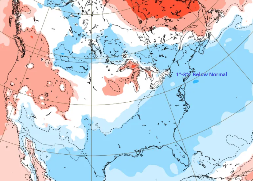
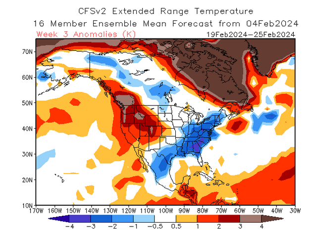
The near mid-month pattern change remains on track. Both the latest ECMWF weeklies and CFSv2 are in strong agreement concerning the February 19-25 period: ECMWF Weeklies: 1°C to 3°C below normal Note: Download issues precluded providing the full map with its corresponding temperature scale The CFSv2: In addition, the Arctic Oscillation (AO) has now gone negative. Its preliminary value for today is -0.369.
-
Only 1930-31 (6.8") had less snow through February 4th than this winter (7.3"). Winter 1930-31 finished with 14.2". Winter 2023-24 is so far the warmest on record for Minneapolis (28.7° mean temperature vs. 27.4° in 1877-78).
-
Typo: Should be 1,352. I accidentally omitted the 1000s in the first post on this matter.
-
32 days for the MJO + specified teleconnections and 352 days for all other cases.
-
For MJO Phases 1,8 (Amplitude 1.000 or above), AO-, EPO-, NAO-, PNA+: February 1975-2023 % of days: 2" or more snow: 27% 4" or more snow: 18% For all other cases: February 1975-2023: 2" or more snow: 17% 4" or more: 10%
-
Final numbers: Warmer and drier than normal.
-
Out West, a major rainstorm was getting underway in California. Through 5 pm EST, Santa Barbara had received 1.16" of rain, breaking the daily record of 0.50" from 1990. In the Northeast, sunshine and mild temperatures prevailed. It could turn briefly cooler for Monday and Tuesday before much warmer air pushes into the region. The temperature could exceed 50° on one or more days late in the week. The generally mild conditions will likely continue into at least the second week of February with only brief interruptions. No Arctic air is likely to reach the area during this time. As a result, the first 10 days of February could wind up 5°-7° above normal in New York City. Potentially, New York City could wind up with a mean temperature of 40.0° or above during the February 1-10 period. Since 1869, there have been 9 prior cases. Five have occurred since 2000 and eight have occurred since 1990: 1952, 1990, 1991, 1999, 2005, 2008, 2012, 2016, and 2020. Seven of those nine years saw less than 10" snowfall for the remainder of the season following February 10th. Only one saw more than 20.0" (22.7", 2005). The least was the trace of snow that fell in 2020. The mean snowfall was 7.2" while the median snowfall was 6.0". In short, were the February 1-10 temperature to average 40.0° or above, that development could be a reinforcing signal for a below to much below normal snowfall season. The second week of February will likely see the evolution toward a sustained colder pattern begin late that week. Overall, February will likely wind up warmer than normal, even as the second half of the month could see a sustained period of colder weather. Single-digit cold is unlikely in New York City. During February, cases with warm ENSO Region 1+2 anomalies see such lows at 55% of frequency as cold ENSO Region 1+2 cases during El Niño winters. During the second half of February, just 17% of cases with a PDO- saw single-digit cold during El Niño winters. January saw a strongly negative PDO. The ENSO Region 1+2 anomaly was +0.7°C and the Region 3.4 anomaly was +1.7°C for the week centered around January 24. For the past six weeks, the ENSO Region 1+2 anomaly has averaged +0.97°C and the ENSO Region 3.4 anomaly has averaged +1.87°C. A basinwide El Niño event is ongoing. The ongoing El Niño event will continue to fade through much of February. The SOI was -28.05 today. The preliminary Arctic Oscillation (AO) was +1.248 today.
-
Typo, it was a PNA+. It shows that the days with such a pattern in February are colder than climatology. Unfortunately, no such database exists for all the variables. Some of the data is revised fairly frequently. MJO phases and amplitudes, especially for recent dates, are revised every few months by the Bureau of Meteorology.


