

donsutherland1
-
Posts
24,194 -
Joined
Content Type
Profiles
Blogs
Forums
American Weather
Media Demo
Store
Gallery
Everything posted by donsutherland1
-
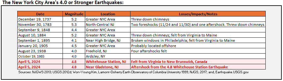
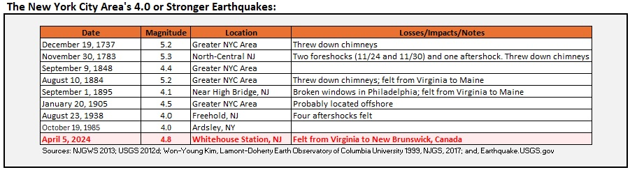
There was a study that once suggested that it would be capable of a Magnitude 6 or 7 earthquake.
-
5.3 is the record.
-
Updated list of 4.0 Earthquakes, assuming the current 4.0 rating holds. Today would be the first date on which there were two such earthquakes in the NYC area.
-
Felt a mild shaking in Larchmont. Wife felt it, too.
-
The next few days will feature readings in the 50s. After a cool first week of April, it will likely turn noticeably warmer next week. Monday should afford partly to mostly sunny skies, allowing for good viewing of the solar eclipse. The warmest day of the week will likely be Tuesday when temperatures rise into the lower 70s in New York City and upper 70s to perhaps near 80° in Washington, DC. A moderate to significant rainfall is possible late in the week. New York City's Central Park remains on track to finish the 2023-2024 snow season with less than 10" of seasonal snowfall for a record second consecutive season. Records go back to 1869. The ENSO Region 1+2 anomaly was -0.4°C and the Region 3.4 anomaly was +1.0°C for the week centered around March 27. For the past six weeks, the ENSO Region 1+2 anomaly has averaged +0.42°C and the ENSO Region 3.4 anomaly has averaged +1.27°C. The ongoing basinwide El Niño event is fading. Neutral conditions could develop later in the spring. The SOI was -16.30 today. The preliminary Arctic Oscillation (AO) was +0.110 today.
-
Under 2.5, people generally don't feel them. The last time I felt an earthquake was in 2021 while on vacation in Bali. It was a strong aftershock from the August 5, 2018 Lombok quake. I wasn't there for the Lombok quake.
-
No. Earthquakes are not part of atmospheric science, so anything related to earthquakes would be an elective course.
-
You can find it here.
-
For those tracking historic earthquakes in the NYC area: So far, there have been six minor aftershocks. Four were magnitude 2.0 or above. The strongest was magnitude 2.2.
-
Four aftershocks ranging from 1.8 to 2.2, so far.
-
So far, there has been one aftershock (2.0).
-
The quake was felt from Virginia to New Brunswick (Canada, not NJ).
-
April 2024 Disco- SNE’s favorite month
donsutherland1 replied to HoarfrostHubb's topic in New England
For perspective: Last daily snowfall of 4.8" or above in NYC: January 30, 2022 Last earthquake of 4.8 or above: April 5, 2024 -
Great information. Yes, the water almost certainly moderated the overall figures. Now, what was unusual warmth is becoming the norm as the climate continues to warm.
-
My sister in Milford, PA in the Delaware River Valley felt it.
-
Very noticeable shaking in Larchmont and audible rumbling.
-
A snowstorm is raging in parts of northern New England. Snowfall amounts include: Bangor: 8.1" (old record: 6.0", 2007) Burlington: 8.8" (old record: 2.7", 2004) Concord: 6.7" Portland: 6.4" (tied record set in 1915) Worcester: 5.5" Following the damaging storm that brought sustained winds as high as 49 mph to the New York City area, sunshine returned and the temperature rose into the 50s. The next few days will feature readings in the 50s. After a cool first week of April, it will likely turn noticeably warmer during the second week of the month. New York City's Central Park remains on track to finish the 2023-2024 snow season with less than 10" of seasonal snowfall for a record second consecutive season. Records go back to 1869. The ENSO Region 1+2 anomaly was -0.4°C and the Region 3.4 anomaly was +1.0°C for the week centered around March 27. For the past six weeks, the ENSO Region 1+2 anomaly has averaged +0.42°C and the ENSO Region 3.4 anomaly has averaged +1.27°C. The ongoing basinwide El Niño event is fading. Neutral conditions could develop later in the spring. The SOI was -12.19 today. The preliminary Arctic Oscillation (AO) was +0.161 today.
-
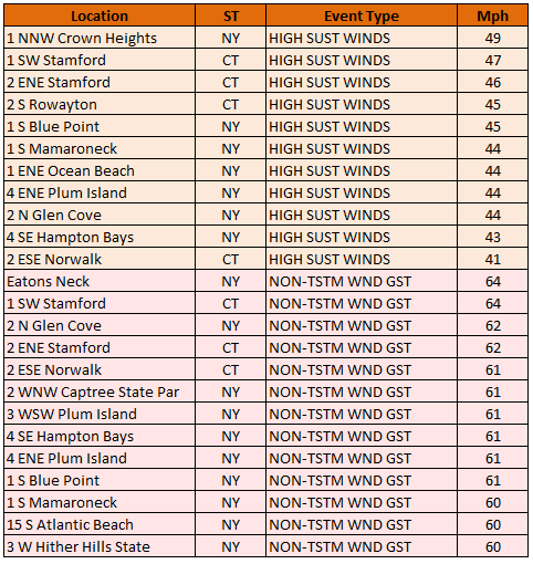
1 NNW Crown Heights in Brooklyn had sustained winds of 49 mph yesterday. Numerous locations reported sustained winds of 40 mph or above in the New York City area and suburbs.
-
Occasional Thoughts on Climate Change
donsutherland1 replied to donsutherland1's topic in Climate Change
No one denies the progress that has been made. But the progress isn't proof that the warming climate is a good thing. Life expectancy gains have increased from a combination of medical breakthroughs, mass warning for severe weather events, etc. Early warning made possible by advances in meteorology and technology for rapid mass dissemination of messages (radio, TV, wireless devices, etc.) have dramatically reduced the incidence of deaths from natural disasters. Electricity has made life better, but that doesn't mean that society must remain irrevocably committed to producing electricity from the burning of fossil fuels and flooding of the atmosphere with CO2. Rapid scaling of existing technology (solar, wind, nuclear, etc.) can begin to dramatically reduce the burning of fossil fuels in the energy sector (not overnight, but on a decadal scale). -
Occasional Thoughts on Climate Change
donsutherland1 replied to donsutherland1's topic in Climate Change
Climate change has played a role throughout the paleo record in driving or contributing to extinctions and reduction in biodiversity. Warmer climates have resulted in higher sea levels, levels that would require abandonment of major coastal megalopolises if they are again reached. Those two bad outcomes. Whether climate change is a cycle (past events) or anthropogenic (current event) is irrelevant. Being cyclical or non-anthropogenic doesn't mean that an outcome is "not bad." The outcomes determine whether it is "bad." Certainly, for the life that suffers or goes extinct, it is "bad." For the new life that emerges, it's arguably a "good" outcome. From the human perspective, as noted above regarding rising sea levels that could culminate in loss of the coastal plain and low-lying islands around the world, it is not good. Although there is no "correct" temperature, theoretically the "correct" temperature range on a habitable planet is the range at which life can exist unaided. So far, some extremophiles have been found at temperatures ranging from near -20C (-4F) to 50C (122F). Complex life requires a narrower range. Technology has expanded the range at which humans can survive, but if biodiversity falls below a threshold or large-scale extinction occurs dramatically reducing food options, the human population would suffer a precipitous and rapid decline. Setting this aside, modern humans evolved during the Holocene. The Holocene temperature range might be the ideal one for humans. On the current trajectory, the world would likely warm 0.3C - 0.5C (0.5F - 0.9F) by 2040. If recent work by James Hansen is correct, the warming would be greater. Either way, the global temperature is on track to reach Pliocene-level temperatures by 2040. Those temperatures are outside the modern human experience. In terms of catastrophic events, it depends on how you define "catastrophic." Summer 2022 saw an estimated 70,000 persons succumb from heat in Europe. Somalia saw 43,000 drought-related deaths, half of which were children, in 2023. Climate change made that drought an estimated 100 times more likely. Summer 2023 provides an example of an unprecedented event for the period of record (1896-present) in Phoenix. July had an average temperature of 102.7F (old monthly mark for any month: 99.1) and there was a 31-consecutive-day stretch (June 30-July 30) of 110F or above high temperatures (old record: 18 days). No American city had ever experienced such a hot month over a monthly period (Death Valley is not a city). That heat was linked to climate change in an attribution study. The climates of the geological past e.g., Paleocene-Eocene Thermal Maximum (PETM) were hotter and more extreme. But CO2 was much higher then, than it is now. Thus, "unprecedented" isn't the best way to examine contemporary anthropogenic climate change. One needs context. One is witnessing unprecedented events over the existing period of record and very likely the warmest temperatures throughout the entire Holocene. -
Occasional Thoughts on Climate Change
donsutherland1 replied to donsutherland1's topic in Climate Change
More and more areas that have been ravaged by fires or floods are also being abandoned outright by insurers. This process is still in its early stages. In a decade or two, the lack of insurance coverage could decimate property values in some of the exposed areas. Worse, given federal deficits and Congressional dysfunction, it is unlikely that the federal government would launch a program where it would become the buyer of last resort. Climate change has real and growing costs. -
Rain and wind will continue into tomorrow with temperatures mainly in the 40s. A storm total 1"-3" rainfall with locally higher amounts is verifying across the region. Coastal flooding at times of high tide is likely. Central and upstate New York and central and northern New England could see accumulating snow, especially in higher elevations and away from the coastline. After a cool first week of April, it will likely turn noticeably warmer during the second week of the month. It is very likely that New York City's Central Park will finish the 2023-2024 snow season with less than 10" of seasonal snowfall for a record second consecutive season. Records go back to 1869. The ENSO Region 1+2 anomaly was -0.4°C and the Region 3.4 anomaly was +1.0°C for the week centered around March 20. For the past six weeks, the ENSO Region 1+2 anomaly has averaged +0.42°C and the ENSO Region 3.4 anomaly has averaged +1.27°C. The ongoing basinwide El Niño event is fading. Neutral conditions could develop later in the spring. The SOI was -11.47 today. The preliminary Arctic Oscillation (AO) was -0.368 today.
-
Select wind reports. The high wind warning has verified at numerous locations.
-
Thunder and lightning in the Bronx.
-
Occasional Thoughts on Climate Change
donsutherland1 replied to donsutherland1's topic in Climate Change
During the far more elevated CO2 regimes, the Earth was a much warmer place than it is today. It was also a place that was far outside the experience of humans. Moreover, past spikes in CO2, often from massive ongoing volcanic activity, led to catastrophic outcomes for most species. The contemporary world is not in a situation similar to when those mass extinctions took place. But it is on a firm trajectory toward the mid-Pliocene Warm Period of 3-4 million years ago. If anything, the political leaders gathered at COP 28 essentially ratified that trajectory in failing to come up with even the earliest caps on CO2 emissions. The world could enter the early stages of this new climate regime by around 2040 on its present path. The world of the mid-Pliocene would be dramatically different from the one in which modern human society evolved. It could result in dramatic and rapid societal simplification, due to food supply-consumption gaps, loss of coastal megacities from 10+ meters of sea level rise (this goes beyond 2100), societal disruptions from aridification, poleward migration of tropical-borne diseases, new viral pathways as migrating specifies come into contact, etc. Once mid-Pliocene conditions set in, there would be the risk that the warmth would be sufficient to trigger the release methane that is currently locked away under the oceans and in permafrost. It's uncertain what temperature threshold would be required to trigger that outcome, but the risk would be far higher than it is today, even with today's warm climate. Even with societal simplification, the world would go on. Arguably, some of the current pressures on biodiversity could be alleviated. But that would be a very bad outcome for human society even if biodiversity begins to heal. That outcome is still an avoidable one and a matter of choice.


