donsutherland1
-
Posts
24,194 -
Joined
Content Type
Profiles
Blogs
Forums
American Weather
Media Demo
Store
Gallery
Everything posted by donsutherland1
-
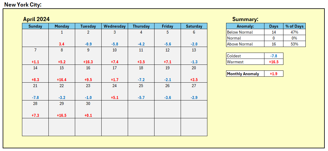
April's daily anomalies for NYC:
-
Clouds broke for some sunshine today in the New York City area where the monthly mean temperature finished at 55.6° (1.9° above normal) after a high temperature of 66°. Farther south, Atlantic City and Philadelphia saw the mercury again reach the 80s. Some showers or perhaps thundershowers are possible tonight but drier weather should return tomorrow. May should see the first week wind up somewhat warmer than normal, even as there is considerable variability in the daily temperatures. Overall, May looks to wind up on the warm side of normal. The ENSO Region 1+2 anomaly was 0.0°C and the Region 3.4 anomaly was +0.8°C for the week centered around April 24. For the past six weeks, the ENSO Region 1+2 anomaly has averaged -0.23°C and the ENSO Region 3.4 anomaly has averaged +0.98°C. The ongoing basinwide El Niño event is fading. Neutral conditions could develop later in the spring. The SOI was -3.82 today. The preliminary Arctic Oscillation (AO) was -1.058 today.
-
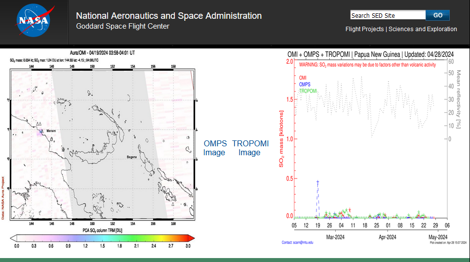
It will depend how much was injected into the stratosphere. The earlier eruption produced about 0.5 terragrams of sulfur dioxide. About 5 terragrams reaching the stratosphere is required to have a significant short-term climate impact. https://earthobservatory.nasa.gov/images/152716/a-blanket-of-ash-from-ruang I haven't seen any data on the most recent eruption, yet, but it should be posted here in coming days: https://so2.gsfc.nasa.gov/measures.html Note: The chart in the above link shows total sulfur dioxide emissions, not solely those that reached the stratosphere.
-
May 2024 temperature forecast contest
donsutherland1 replied to Roger Smith's topic in Weather Forecasting and Discussion
DCA _ NYC _ BOS __ ORD _ ATL _ IAH __ DEN _ PHX _ SEA 1.1 1.2 1.1 0.8 0.9 0.9 0.5 0.5 0.7 -
Thunderstorms are moving across parts of the region this evening. A few locations could experience strong wind gusts and hail. In the wake of today's early-season heat, readings will trend closer to normal levels for tomorrow. May should see the first week wind up somewhat warmer than normal. The ENSO Region 1+2 anomaly was 0.0°C and the Region 3.4 anomaly was +0.8°C for the week centered around April 24. For the past six weeks, the ENSO Region 1+2 anomaly has averaged -0.23°C and the ENSO Region 3.4 anomaly has averaged +0.98°C. The ongoing basinwide El Niño event is fading. Neutral conditions could develop later in the spring. The SOI was -2.31 today. The preliminary Arctic Oscillation (AO) was -0.532 today. Based on sensitivity analysis applied to the latest guidance, there is an implied near 100% probability that New York City will have a warmer than normal April (1991-2020 normal). April will likely finish with a mean temperature near 55.8° (2.1° above normal).
-
JFK hit 82
-
87 at NYC.
-
The evolving ENSO transition favors a hot summer. I suspect that many parts of the NYC area will have a shot at 100 this summer. We'll have to see if the heat penetrates Central Park's forest.
-
You're probably right. Maybe he'll dig out the 1816 analog for June given his practice of using antiquated and irrelevant analogs.
-
JB has moved past what turned out to be his latest missed call and is talking about a pattern similar to 1966 and 1977 for the second week of May.
-
Speaking of JB, we just made it through his latest forecast period of “major cold.” The NYC temperature anomaly for April 25-28 was 1.3 degrees below normal. That was the 98th coldest April 25-28 period on record. Records go back to 1869.
-
Tomorrow will likely be the warmest day of the week with widespread readings in the upper 70s and lower 80s. The hottest spots could reach the middle or upper 80s with perhaps a few 90° highs. May remains on course to start out with warmer to much warmer than normal temperatures. The ENSO Region 1+2 anomaly was -0.2°C and the Region 3.4 anomaly was +0.7°C for the week centered around April 10. For the past six weeks, the ENSO Region 1+2 anomaly has averaged -0.17°C and the ENSO Region 3.4 anomaly has averaged +1.03°C. The ongoing basinwide El Niño event is fading. Neutral conditions could develop later in the spring. The SOI was -5.12 today. The preliminary Arctic Oscillation (AO) was -0.920 today. Based on sensitivity analysis applied to the latest guidance, there is an implied near 100% probability that New York City will have a warmer than normal April (1991-2020 normal). April will likely finish with a mean temperature near 55.6° (1.9° above normal).
-
Overnight, parts of the region could see a shower or two, as a warm front pushes slowly across the region. In its wake, tomorrow will turn noticeably warmer as the sun returns. The temperature will surge into the 70s in much of the region. Monday could be the warmest day of the week with widespread readings in the upper 70s and lower 80s. The hottest spots could reach the middle or upper 80s with perhaps a few 90° highs. May will likely start out with warmer to much warmer than normal temperatures. The ENSO Region 1+2 anomaly was -0.2°C and the Region 3.4 anomaly was +0.7°C for the week centered around April 10. For the past six weeks, the ENSO Region 1+2 anomaly has averaged -0.17°C and the ENSO Region 3.4 anomaly has averaged +1.03°C. The ongoing basinwide El Niño event is fading. Neutral conditions could develop later in the spring. The SOI was -3.10 today. The preliminary Arctic Oscillation (AO) was -0.814 today. Based on sensitivity analysis applied to the latest guidance, there is an implied near 100% probability that New York City will have a warmer than normal April (1991-2020 normal). April will likely finish with a mean temperature near 55.6° (1.9° above normal).
-
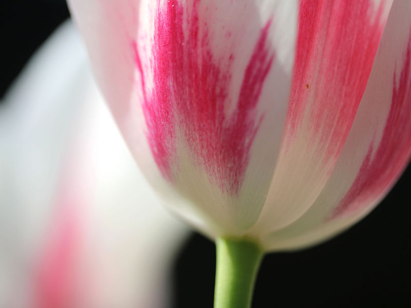
Tulip season is now ending in a blaze of glory at the New York Botanical Garden. Five photos:


-
The mainly fair weather will continue after another cool start, particularly outside of Philadelphia and New York City. However, it will likely turn noticeably warmer on Sunday. Monday could be the warmest day of the week with widespread readings in the upper 70s and lower 80s. The hottest spots could reach the middle or upper 80s. May will likely start out with warmer to much warmer than normal temperatures. The ENSO Region 1+2 anomaly was -0.2°C and the Region 3.4 anomaly was +0.7°C for the week centered around April 10. For the past six weeks, the ENSO Region 1+2 anomaly has averaged -0.17°C and the ENSO Region 3.4 anomaly has averaged +1.03°C. The ongoing basinwide El Niño event is fading. Neutral conditions could develop later in the spring. The SOI was +0.58 today. The preliminary Arctic Oscillation (AO) was -0.942 today. Based on sensitivity analysis applied to the latest guidance, there is an implied 99% probability that New York City will have a warmer than normal April (1991-2020 normal). April will likely finish with a mean temperature near 55.5° (1.8° above normal).
-
No. JFK's record is 1.9" on March 14, 1972 with a low temperature of 36°.
-
It will be another chilly night with the temperature falling into the lower 40s in New York City. Readings near or below freezing are possible well north and west of New York City tonight where some frost is likely tomorrow morning. After a cold start, the temperature will rise into the upper 50s and lower 60s across the region. It will likely turn noticeably warmer on Sunday as April nears an end. Monday could be the warmest day of the week with widespread readings in the upper 70s and lower 80s. The hottest spots could reach the middle or upper 80s. May will likely start out with warmer to much warmer than normal temperatures. The ENSO Region 1+2 anomaly was -0.2°C and the Region 3.4 anomaly was +0.7°C for the week centered around April 10. For the past six weeks, the ENSO Region 1+2 anomaly has averaged -0.17°C and the ENSO Region 3.4 anomaly has averaged +1.03°C. The ongoing basinwide El Niño event is fading. Neutral conditions could develop later in the spring. The SOI was -14.28 today. The preliminary Arctic Oscillation (AO) was -1.550 today. Based on sensitivity analysis applied to the latest guidance, there is an implied 96% probability that New York City will have a warmer than normal April (1991-2020 normal). April will likely finish with a mean temperature near 55.2° (1.5° above normal).
-
JFK had 1.5" on April 19, 1983. The low temperature was 35°.
-
A strong shot of cold will overspread the region tonight. The temperature will fall into the lower 40s and perhaps even upper 30s in New York City tomorrow morning. Readings near or below freezing are possible well north and west of the City tonight and tomorrow night. The mercury will remain in the 50s throughout tomorrow. It will likely turn noticeably warmer on Sunday as April nears an end. May will likely start out with warmer to much warmer than normal temperatures. The ENSO Region 1+2 anomaly was -0.2°C and the Region 3.4 anomaly was +0.7°C for the week centered around April 10. For the past six weeks, the ENSO Region 1+2 anomaly has averaged -0.17°C and the ENSO Region 3.4 anomaly has averaged +1.03°C. The ongoing basinwide El Niño event is fading. Neutral conditions could develop later in the spring. The SOI was -15.50 today. The preliminary Arctic Oscillation (AO) was -1.523 today. Based on sensitivity analysis applied to the latest guidance, there is an implied 93% probability that New York City will have a warmer than normal April (1991-2020 normal). April will likely finish with a mean temperature near 55.2° (1.5° above normal).
-
Get well soon.
-
Tomorrow will be a warm day, though there will be a risk of a shower or even thundershower. Overall, generally cooler than normal conditions will likely persist through most of the week. It will likely turn noticeablywarmer as April concludes with May starting with warmer to much warmer than normal temperatures. The ENSO Region 1+2 anomaly was -0.2°C and the Region 3.4 anomaly was +0.7°C for the week centered around April 10. For the past six weeks, the ENSO Region 1+2 anomaly has averaged -0.17°C and the ENSO Region 3.4 anomaly has averaged +1.03°C. The ongoing basinwide El Niño event is fading. Neutral conditions could develop later in the spring. The SOI was -14.06 today. The preliminary Arctic Oscillation (AO) was -1.022 today. Based on sensitivity analysis applied to the latest guidance, there is an implied 88% probability that New York City will have a warmer than normal April (1991-2020 normal). April will likely finish with a mean temperature near 55.0° (1.3° above normal).
-
Probably Sunday.
-
No snow was recorded at JFK. But it was mostly cloudy with cold rain.
-
No. JFK's lowest May temperature is 34° (May 10, 1966 and May 9, 2020).
-
Occasional Thoughts on Climate Change
donsutherland1 replied to donsutherland1's topic in Climate Change
The fossil fuel industry has warped political and public opinion. It is the beneficiary of $7 trillion in annual subsidies according to the IMF's 2023 report and earns tens of billions of dollars in annual profits. It wants to burn through all fossil fuel resources to maximize the lifetime profits possible from such an outcome, especially as it is not required to pay for any of the damage it inflicts from climate change and its impacts. As a result, it has devoted funds and effort to undermining public understanding of the consequences of its injecting enormous amounts of greenhouse gases into the atmosphere each year. The information ecosystem is deficient to the challenge. Social Media has few if any checks on disinformation, hence climate denial continues to prosper there. Unfortunately, a growing share of the public obtains some or most of its information from Social Media. Even the mainstream media with a few exceptions, devotes very little coverage to climate change. For example, aside from a handful of outlets, none connected the recent rains in Dubai/UAE to climate change despite climate modeling calling for an increased frequency of excessive rains in that region, very few noted that the recent extreme heat in Africa's Sahel Region would have been "virtually impossible" without climate change, and few if any have connected the raging heatwave across south Asia to climate change despite a 2023 attribution paper that covered a similar and somewhat lesser April heatwave there. This material omission from sources of information, including credible sources, further undercuts the urgency of addressing climate change at a time when a still relatively smooth transition is possible. By 2030, the transition required to hold warming to 1.5C to 2.0C will be fairly disruptive and painful. By then, policy makers will likely claim that the required changes are "unrealistic"--that the required changes will become drastic would be the payoff on decades of relative policy inaction. Younger people's and future generations' wellbeing would be sacrificed on the altar of fossil fuels and shortsighted status quo thinking. Finally, even as a number of countries are rapidly expanding their clean energy infrastructure/capacity, those countries are avoiding setting targets for rapidly phasing out fossil fuel burning. In fact, oil and gas production is growing, not shrinking. For all the political rhetoric, the U.S. is a big reason global oil and gas production is increasing, not falling. From the EIA: Although forecast OPEC+ crude oil production in 2024 decreases by 0.9 million b/d compared with last year, forecast production outside of OPEC+ increases by 1.8 million b/d, led by the United States, Guyana, Brazil, and Canada. Global liquid fuels production in our forecast increases by 2.0 million b/d in 2025 as the OPEC+ production cuts expire and supply growth outside of OPEC+ continues to grow. An "all of the above" energy approach is a guarantee that the world won't meet its Paris Agreement commitments.