donsutherland1
-
Posts
24,194 -
Joined
Content Type
Profiles
Blogs
Forums
American Weather
Media Demo
Store
Gallery
Everything posted by donsutherland1
-
Tomorrow will be another refreshing day with highs in the upper 70s to lower 80s. A few spots could see a shower or thundershower. Through early next week, temperatures will continue to reach the upper 70s and lower 80s. A warming trend will likely commence after midweek. Following New York City's 4th warmest spring and Philadelphia's 6th warmest spring, there is a distinct possibility that June 2024 will rank among the 10 warmest Junes on record in both cities. Records go back to 1869 in New York City and 1874 in Philadelphia. The latest summer guidance continues to suggest a warmer to much warmer than normal summer lies ahead. The ENSO Region 1+2 anomaly was -1.1°C and the Region 3.4 anomaly was +0.1°C for the week centered around May 29. For the past six weeks, the ENSO Region 1+2 anomaly has averaged -0.48°C and the ENSO Region 3.4 anomaly has averaged +0.35°C. Neutral ENSO conditions are underway. The neutral ENSO will likely evolve into a La Niña event during the summer or perhaps early fall. The SOI was -18.98 today. The preliminary Arctic Oscillation (AO) was -1.584 today. Based on sensitivity analysis applied to the latest guidance, there is an implied 80% probability that New York City will have a warmer than normal June (1991-2020 normal). June will likely finish with a mean temperature near 75.1° (3.1° above normal).
-
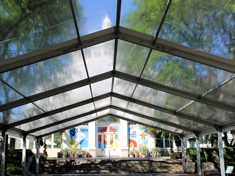
Under brilliant sunshine, a refreshing breeze, and an active breeze, the New York Botanical Garden is about as picturesque as it gets.


-
Occasional Thoughts on Climate Change
donsutherland1 replied to donsutherland1's topic in Climate Change
With a high of 106° yesterday, Del Rio has now had its second extreme heat event (Clarke et al., 2014 methodology) of the year. For the first time, that city has had two extreme heat events in two consecutive years. All cases with two extreme heat events have occurred since 2000. Full-year records go back to 1906. The list of extreme heat events is below. Years with two such events are highlighted in red. Climate change has driven a warming of Del Rio's climate. Summers have warmed 2.1° from 1961-1990 84.3°) to 1991-2020 (86.4°). During 1961-1990, the hottest summer (1980) had an average temperature of 87.4°. Since 2010, eight summers have been hotter, including the last six summers (2018-2023). The pre-2000 record of 88.6° from 1998 has been surpassed in five summers since 2010 and three of the last four summers. Put another way, what was once an extreme outlier summer is on track toward becoming a routine summer in the contemporary warmer climate. This warming has led to a dramatic increase in the frequency of 100° and 105° days. The number of 100° days have increased from 21.0 days per year to 41.1 days per year (1961-1990 to 1991-2020). During the 1991-2020 period, 102° days (22.1 per year) were about as frequent as 100° days were during 1961-1990. During the same reference periods, the number of 105° days has risen from 1.4 days to 5.9 days per year. As summers have warmed and intense heat has grown more common, extreme heat events have increased in frequency. This year saw the two earliest such events on record. Through June 7th, Del Rio has seen 23 100° days. It has also had 11 105° days.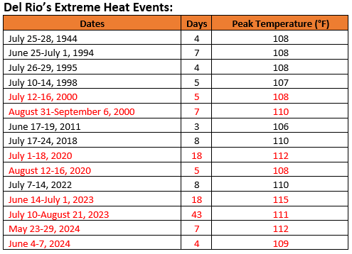
-
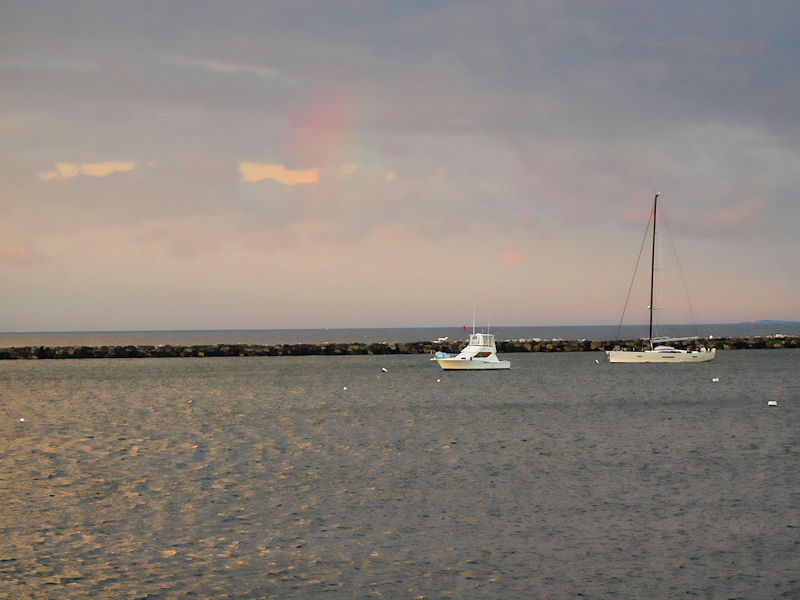
Some evening shots during the passage of a distant thunderstorm near sunset:


-
A period of generally dry weather will commence tomorrow. Rainfall amounts will be limited during this period. Through early next week, temperatures will likely reach the upper 70s and lower 80s. A warming trend could commence after midweek. Following New York City's 4th warmest spring and Philadelphia's 6th warmest spring, there is a distinct possibility that June 2024 will rank among the 10 warmest Junes on record in both cities. The first week of June was the 14th warmest on record for New York City and 10th warmest on record for Philadelphia. Records go back to 1869 in New York City and 1874 in Philadelphia. The latest summer guidance continues to suggest a warmer to much warmer than normal summer lies ahead. The ENSO Region 1+2 anomaly was -1.1°C and the Region 3.4 anomaly was +0.1°C for the week centered around May 29. For the past six weeks, the ENSO Region 1+2 anomaly has averaged -0.48°C and the ENSO Region 3.4 anomaly has averaged +0.35°C. Neutral ENSO conditions are underway. The neutral ENSO will likely evolve into a La Niña event during the summer or perhaps early fall. The SOI was -26.64 today. The preliminary Arctic Oscillation (AO) was -1.139 today. Based on sensitivity analysis applied to the latest guidance, there is an implied 78% probability that New York City will have a warmer than normal June (1991-2020 normal). June will likely finish with a mean temperature near 75.0° (3.0° above normal).
-
Occasional Thoughts on Climate Change
donsutherland1 replied to donsutherland1's topic in Climate Change
Dr. Stefan Ramstorf's recent lecture on the AMOC. He has researched the AMOC for more than 30 years and been published widely in the scientific literature. https://x.com/rahmstorf/status/1799048979004678651 -
An extended period of generally drier weather will commence tomorrow. Through early next week, temperatures will likely reach the upper 70s and lower 80s. There are some hints on the guidance that it could begin to turn warmer to perhaps hot after mid-month. The latest summer guidance continues to suggest a warmer to much warmer than normal summer lies ahead. The ENSO Region 1+2 anomaly was -1.1°C and the Region 3.4 anomaly was +0.1°C for the week centered around May 29. For the past six weeks, the ENSO Region 1+2 anomaly has averaged -0.48°C and the ENSO Region 3.4 anomaly has averaged +0.35°C. Neutral ENSO conditions are underway. The neutral ENSO will likely evolve into a La Niña event during the summer or perhaps early fall. The SOI was -26.92 today. The preliminary Arctic Oscillation (AO) was -0.756 today.
-
In addition to the tornado outbreak in parts of the Delaware and Maryland areas, rainfall in the Mid-Atlantic region is exceeding the guidance at some locations. Through 11:12 pm, Wilmington, DE has picked up 2.07" of rain and Philadelphia has seen 0.96". In short, while most areas will likely see 0.25"-0.75" as per the guidance, there will likely be pockets with 1"-2" amounts.
-
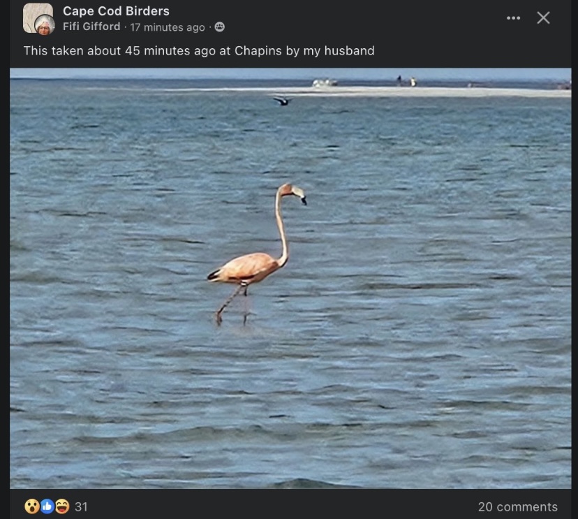
Yes, the color is a function of diet. I'm not sure what it is eating up in Cape Cod.
-
Showers, thundershowers, and periods of rain will likely arrive tonight and continue through tomorrow. A general 0.25"-0.75" rainfall is likely. In the wake of the system, temperatures will reach the upper 70s and lower 80s into the weekend. The latest summer guidance continues to suggest a warmer to much warmer than normal summer lies ahead. The ENSO Region 1+2 anomaly was -1.1°C and the Region 3.4 anomaly was +0.1°C for the week centered around May 29. For the past six weeks, the ENSO Region 1+2 anomaly has averaged -0.48°C and the ENSO Region 3.4 anomaly has averaged +0.35°C. Neutral ENSO conditions are underway. The neutral ENSO will likely evolve into a La Niña event during the summer or perhaps early fall. The SOI was -18.70 today. The preliminary Arctic Oscillation (AO) was -0.425 today.
-
Showers, thundershowers, and periods of rain will likely arrive tomorrow night or Thursday. A general 0.25"-0.75" rainfall is likely. In the wake of the system, temperatures will reach the upper 70s and lower 80s into the weekend. The latest summer guidance continues to suggest a warmer to much warmer than normal summer lies ahead. The ENSO Region 1+2 anomaly was -1.1°C and the Region 3.4 anomaly was +0.1°C for the week centered around May 29. For the past six weeks, the ENSO Region 1+2 anomaly has averaged -0.48°C and the ENSO Region 3.4 anomaly has averaged +0.35°C. Neutral ENSO conditions are underway. The neutral ENSO will likely evolve into a La Niña event during the summer or perhaps early fall. The SOI was -2.18 today. The preliminary Arctic Oscillation (AO) was -0.189 today.
-
Occasional Thoughts on Climate Change
donsutherland1 replied to donsutherland1's topic in Climate Change
AMOC breakdown risk: This isn't necessary the most likely scenario, but an illustration of an uncomfortably high short-term probability. The underlying paper can be found here: https://nyaspubs.onlinelibrary.wiley.com/doi/full/10.1111/nyas.14659 -
Thank you.
-
I now post screenshots.
-
Speaking of flamingos, one has reached Cape Cod.
-
Under mostly sunny skies, the temperature rose to 84° at Islip, 86° in New York City, 89° at Newark, and 87° at Philadelphia. The Islip reading missed the daily record by 2°. Tomorrow will be somewhat cooler with highs in the upper 70s to perhaps lower 80s. Rain will likely arrive late Wednesday or Thursday. In the wake of the system, temperatures will reach the upper 70s into the weekend. The latest summer guidance continues to suggest a warmer to much warmer than normal summer lies ahead. The ENSO Region 1+2 anomaly was -1.1°C and the Region 3.4 anomaly was +0.1°C for the week centered around May 29. For the past six weeks, the ENSO Region 1+2 anomaly has averaged -0.48°C and the ENSO Region 3.4 anomaly has averaged +0.35°C. Neutral ENSO conditions are underway. The neutral ENSO will likely evolve into a La Niña event during the summer or perhaps early fall. The SOI was -17.36 today. The preliminary Arctic Oscillation (AO) was -0.157 today.
-
After perhaps a brief shower, tomorrow will be partly to mostly sunny with temperatures topping out in the upper 70s and lower 80s. Warm spots could again reach the middle 80s. Rain could arrive late Wednesday or Thursday. In the wake of the system, temperatures will continue to reach the upper 70s and lower 80s into the weekend. The latest summer guidance continues to suggest a warmer to much warmer than normal summer lies ahead. The ENSO Region 1+2 anomaly was -1.1°C and the Region 3.4 anomaly was +0.2°C for the week centered around May 22. For the past six weeks, the ENSO Region 1+2 anomaly has averaged -0.40°C and the ENSO Region 3.4 anomaly has averaged +0.45°C. Neutral conditions are imminent. The SOI was -10.33 today. The preliminary Arctic Oscillation (AO) was -0.403 today.
-
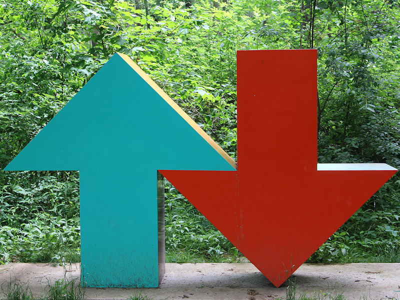
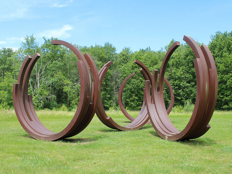
Temperatures rose into the lower 80s in Ghent, NY making for a good day for viewing some of the sculptures at Art Omi.

-
Occasional Thoughts on Climate Change
donsutherland1 replied to donsutherland1's topic in Climate Change
Thank you for posting this information. The rankings make clear that Heller's chart is inaccurate. I went to the tool and exported the data. Just 0.3% of the stations were 4th lowest in terms of the number of 80F days through May 31. There is no plausible way 2024 ranked fourth lowest. -
Tomorrow will be partly to mostly sunny with temperatures topping out in the upper 70s and lower 80s. Warm spots could again reach the middle 80s. Rain could arrive late Wednesday or Thursday. The latest summer guidance continues to suggest a warmer to much warmer than normal summer lies ahead. The ENSO Region 1+2 anomaly was -1.1°C and the Region 3.4 anomaly was +0.2°C for the week centered around May 22. For the past six weeks, the ENSO Region 1+2 anomaly has averaged -0.40°C and the ENSO Region 3.4 anomaly has averaged +0.45°C. Neutral conditions are imminent. The SOI was +4.23 today. The preliminary Arctic Oscillation (AO) was -0.635 today.
-
Occasional Thoughts on Climate Change
donsutherland1 replied to donsutherland1's topic in Climate Change
I didn't mean that the data in the chart is not meaningful. However, there are better ways to judge overall temperatures for subseasonal and seasonal periods. For example, using only metrics such as used by Heller, there could be a July where the temperature spikes to let's say 100° in Philadelphia, but the month overall could wind up cooler than normal. Heller's type of analysis would flag it as "hot" if he is scoring things based on 100° days. Meanwhile, there could be another July where the monthly anomaly is +2.5°, but the highest maximum temperature is 97°. If Heller is using 100° days, his analysis would flag the month as "cool." Period average highs, lows, and means do a better job in assessing the outcome for the period in question. -
Occasional Thoughts on Climate Change
donsutherland1 replied to donsutherland1's topic in Climate Change
More than likely, the ongoing marine heatwaves in the Gulf of Mexico and Caribbean are contributing to the excessive warmth seen in Florida, Cuba, Puerto Rico, etc. The dry conditions are likely amplifying the heat in northeast Mexico and southwest Texas. It is plausible that a global threshold has been passed. I suspect the outcomes during and after the developing La Niña will provide greater insight. -
Texas 2024 Discussion/Observations
donsutherland1 replied to Stx_Thunder's topic in Central/Western States
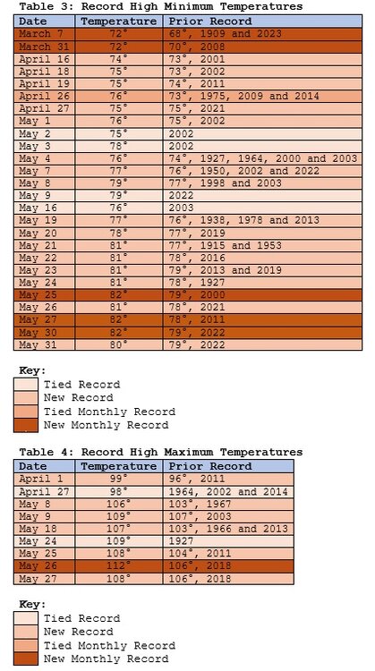
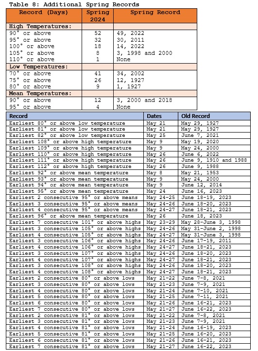
Brownsville experienced its warmest May on record. Brownsville's May was also warmer than any June on record. Some records from Florida, Puerto Rico, and Texas: Del Rio demolished its May and Spring records. It also had its first May extreme heat event (Clarke et al., 2014 methodology) on record. Some highlights from Del Rio: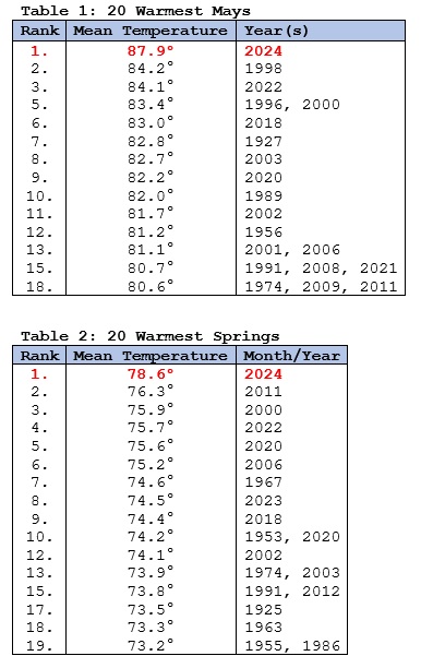
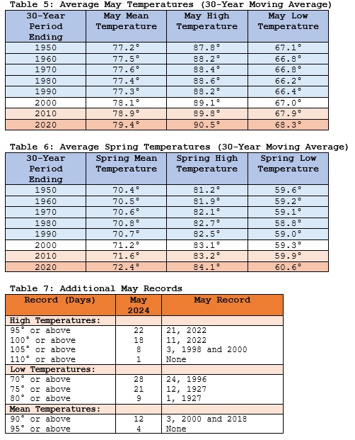
-
Occasional Thoughts on Climate Change
donsutherland1 replied to donsutherland1's topic in Climate Change
Numerous U.S. cities had their warmest #May on record, some by tremendous margins. In a number, May 2024 would have ranked among the 10 warmest Junes on record. In Brownsville and Fort Lauderdale, the May temperature exceeded both the May and June records.
-
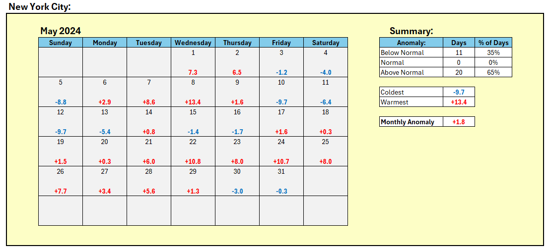
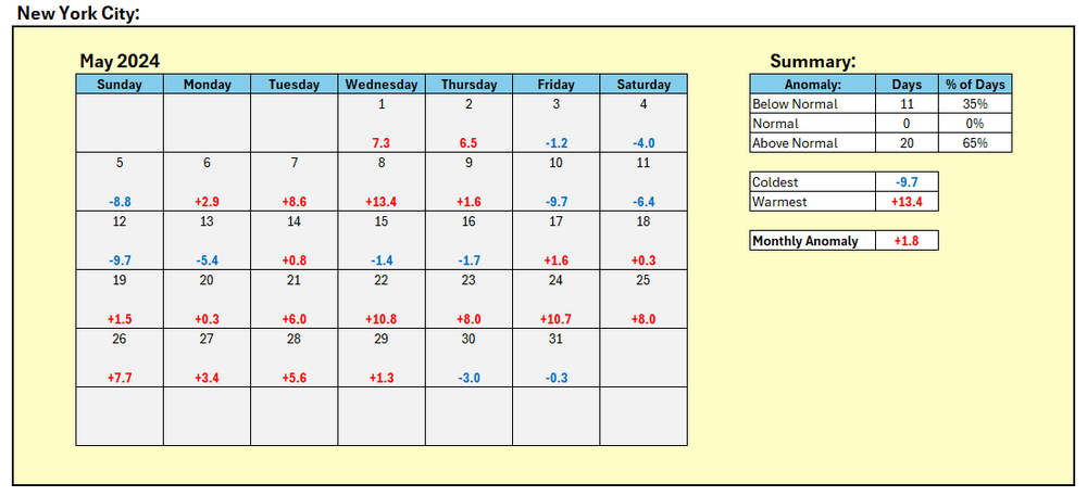
May calendar day summary for New York City:
- 1,603 replies
-
- 3
-

-
- spring
- cool temps
- (and 3 more)