donsutherland1
-
Posts
24,194 -
Joined
Content Type
Profiles
Blogs
Forums
American Weather
Media Demo
Store
Gallery
Everything posted by donsutherland1
-
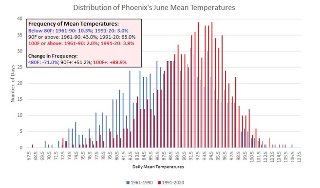
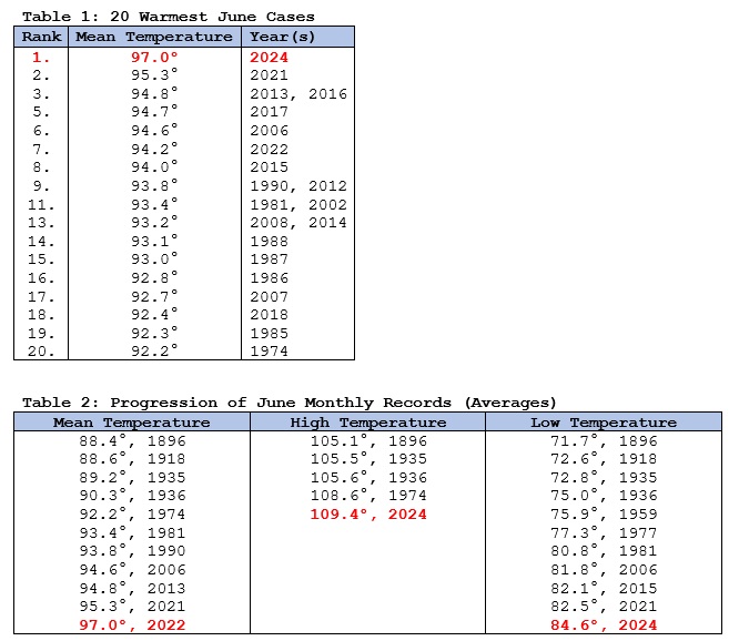
In an increasingly hot world driven by anthropogenic climate change, Phoenix experienced its hottest June on record with a monthly mean temperature of 97.0°. What was most noticeable this month was the duration of sustained high heat, as was the case during that city’s record 31-day stretch of 110° or above high temperatures last year. Anthropogenic climate change is driving a warming of Phoenix's summers. It is making hot patterns hotter. Hot nights are amplified by the Urban Heat Island (UHI) Effect. Climate change is also increasing the persistence of hot patterns through wave resonance events. The observed global warming since the 1950s is unequivocal with anthropogenic greenhouse gas emissions, largely from the burning of fossil fuels, being the dominant driver of that warming. Phoenix’s full-year records go back to 1896. The first summer to average 95.0° or above occurred in 2013 (95.1°). Summer 2015 matched the 2013 record. Summer 2020, which set a record for most 100° days (145) set a new benchmark at 96.7°. Three years later, that mark was incinerated by a 97.1° average summer temperature. Since 1980, Phoenix’s summers have been warming at a rate of 0.9° per decade. June is also warming rapidly. The monthly mean temperature has increased 3.2° from the 1961-1990 period to the 1991-2020 period. June 2006 was the first June to attain a mean temperature of 94.0° or above (94.6°). That mark was then broken in 2013 (94.8°) and 2021 (95.3°). The 2021 record was demolished this year. Since 2015, six of the ten Junes have had a monthly mean temperature of 94.0° or above. Put another way, June heat that was once extraordinary is now on a path toward becoming normal. Select Highlights: Updates: Phoenix's warming summers Phoenix Experiences its Hottest Summer on Record
-
June will be finishing with a monthly mean temperature of 75.2° in New York City. That will tie June 2024 with June 1994 as the third warmest June on record. Farther south, Baltimore recorded its 5th 96° or above high temperature this month. That ties the June record set in 1991 and tied in 2010 and 2012. July will then get off to a pleasant start. Temperatures could run somewhat below normal for the first three days before it turns warmer. Overall, the month looks to be warmer to much warmer than normal. The latest summer guidance continues to suggest a warmer to much warmer than normal summer lies ahead. The ENSO Region 1+2 anomaly was -0.9°C and the Region 3.4 anomaly was 0.3°C for the week centered around June 19. For the past six weeks, the ENSO Region 1+2 anomaly has averaged -0.88°C and the ENSO Region 3.4 anomaly has averaged +0.15°C. Neutral ENSO conditions will likely evolve into a La Niña event during the late summer or early fall. The SOI was +13.43 today. The preliminary Arctic Oscillation (AO) was +1.907 today.
-
Brief gusty thunderstorm:
-
Occasional Thoughts on Climate Change
donsutherland1 replied to donsutherland1's topic in Climate Change
Absolutely. The numbers there are obviously wrong. They should not be relied upon. -
Occasional Thoughts on Climate Change
donsutherland1 replied to donsutherland1's topic in Climate Change
The regression analysis I ran also showed a clear bias at Phoenixville relative to nearby sites. The 1915-48 period there is unreliable. I am strongly confident that Phoenixville never got close to 44 95° days. -
July 2024 temperature forecast contest
donsutherland1 replied to Roger Smith's topic in Weather Forecasting and Discussion
DCA _ NYC _ BOS __ ORD _ ATL _ IAH __ DEN _ PHX _ SEA 2.0 2.0 1.8 2.1 2.2 1.0 1.5 1.8 0.2 -
Tomorrow will be variably cloudy and very warm with some showers and thunderstorms. The potential exists for some strong or severe thunderstorms. Another cooler air mass will overspread the region tomorrow night. July will then get off to a pleasant start, but the month looks warmer to much warmer than normal overall. Following New York City's 4th warmest spring and Philadelphia's 6th warmest spring, it is very likely that June 2024 will rank among the 10 warmest Junes on record in both cities. Records go back to 1869 in New York City and 1874 in Philadelphia. The latest summer guidance continues to suggest a warmer to much warmer than normal summer lies ahead. The ENSO Region 1+2 anomaly was -0.9°C and the Region 3.4 anomaly was 0.3°C for the week centered around June 19. For the past six weeks, the ENSO Region 1+2 anomaly has averaged -0.88°C and the ENSO Region 3.4 anomaly has averaged +0.15°C. Neutral ENSO conditions will likely evolve into a La Niña event during the late summer or early fall. The SOI was +26.01 today. The preliminary Arctic Oscillation (AO) was +1.176 today. Based on sensitivity analysis applied to the latest guidance, there is an implied near 100% probability that New York City will have a warmer than normal June (1991-2020 normal). June will likely finish with a mean temperature near 75.3° (3.3° above normal). That would make June 2024 the third warmest June on record.
-
Without doubt, UHI plays a prominent role. Unfortunately, Phoenix has no nearby USCRN sites for closer comparison. I suspect that most of the pre-2000 warming was due to UHI, but most of the 2000-present warming is due to climate change. Although not a perfect proxy for Phoenix, Tucson has a nearby USCRN site (Tucson 11W). Summers have warmed at the USCRN site by 0.83° per decade since 2003 (beginning of its record). At Tucson, summers have warmed by nearly 1.26° per decade. As USCRN sites are on areas that are not being developed and have overall stable site characteristics, they provide a good measure for changes attributed solely to climate change. Comparing trends between the two sites, just under two-thirds of Tucson's summer warming (2003-2023) was attributable to climate change; nearly one-third was attributable to its expanding UHI. To cross check, I looked further at Tucson's population change from 2003-2023. Population is a good proxy for UHI. Tucson's population rose 33.8%. That is almost identical to the share of Tucson's excess warming relative to the warming at the USCRN site.
-
Occasional Thoughts on Climate Change
donsutherland1 replied to donsutherland1's topic in Climate Change
Whenever Phoenix and Tucson experience exceptional heat, climate change denial accounts attribute the heat due to the cities' Urban Heat Island (UHI) Effect. They take cover behind the fact that UHI is a real phenomenon. However, on closer inspection, their argument disintegrates when comparisons are made with trends at U.S. Climate Reference Network (USCRN) sites. Phoenix does not have a nearby USCRN site. However, Tucson does. The Tucson 11W USCRN site has seen summers warm by about 0.83F per decade since it started reporting in 2003. Tucson has seen summers warm by about 1.26F per decade during that same period. USCRN sites are those that have been selected for their stability (no changes such as urban development). Thus, they offer a good proxy for assessing changes purely due to climate change. If one assumes that the Tucson 11W provides a good proxy for the impact of climate change in the area, including Tucson, then one can attribute the additional warming of Tucson to non-AGW factors, principally UHI. That assessment finds that nearly two-thirds of the summer warming that has occurred in Tucson is due to AGW. The remainder is due to UHI. One can get greater confidence in this assessment by taking a look at the Tucson population data from 2003-2023. during that time, Tucson's population grew 33.8% which is virtually identical to the share of warmth the USCRN comparison attributes to UHI. Therefore one can confidently assert that nearly two-thirds of Tucson's increasing warmth during summers is being driven by climate change, not UHI.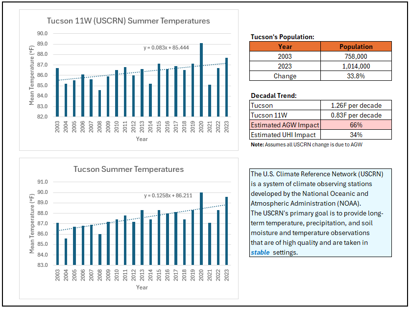
-
This is a difficult post to make. However, it is a necessary one given the importance of data integrity and possibility others may not be fully aware of what is going on. As winter approaches and JB issues his seasonal forecast (probably a cold and snowy one, especially if he locks in his most recently hinted 2013-14 and 2014-15 analogs), one should beware that he has developed a tendency in "invent" data for lack of a better word to describe his practice. In short, if he makes claims about data to verify parts of his seasonal forecast, which follows two catastrophically bad winter seasonal forecasts, one should verify the claims. They can no longer be taken at face value. For example, below are recent claims he made about Phoenix. Almost certainly, they were made to dismiss the magnitude of its growing heat based on multiple tweets toward that end. For perspective concerning the heatwave story to which he reacted, last year he dismissed what would become the record 31-day heatwave cited by AP. Early on, he expected it to fall short of the record (18 days at the time). Once it occurred, he asserted that the previous record 18-day 1974 heatwave was more severe. In fact, the 31-day heatwave was hotter on all objective measures: average high, average low, average mean, highest maximum and highest minimum temperatures.
-
Tomorrow will be variably cloudy with some showers and thunderstorms that could linger into Sunday. It could burn briefly noticeably warmer on Sunday prior to the arrival of another cooler air mass. Following New York City's 4th warmest spring and Philadelphia's 6th warmest spring, it is very likely that June 2024 will rank among the 10 warmest Junes on record in both cities. Records go back to 1869 in New York City and 1874 in Philadelphia. The latest summer guidance continues to suggest a warmer to much warmer than normal summer lies ahead. The ENSO Region 1+2 anomaly was -0.9°C and the Region 3.4 anomaly was 0.3°C for the week centered around June 19. For the past six weeks, the ENSO Region 1+2 anomaly has averaged -0.88°C and the ENSO Region 3.4 anomaly has averaged +0.15°C. Neutral ENSO conditions will likely evolve into a La Niña event during the late summer or early fall. The SOI was +30.65 today. The preliminary Arctic Oscillation (AO) was +0.442 today. Based on sensitivity analysis applied to the latest guidance, there is an implied near 100% probability that New York City will have a warmer than normal June (1991-2020 normal). June will likely finish with a mean temperature near 75.4° (3.4° above normal). That would tie June 2024 with June 1966 as the second warmest June on record.
-
Cooler and less humid air pushed into the region today following last night's thunderstorms. A refreshing weekend lies ahead. However showers and periods of rain will likely arrive on Saturday and continue into Sunday. Following New York City's 4th warmest spring and Philadelphia's 6th warmest spring, it is very likely that June 2024 will rank among the 10 warmest Junes on record in both cities. Records go back to 1869 in New York City and 1874 in Philadelphia. The latest summer guidance continues to suggest a warmer to much warmer than normal summer lies ahead. The ENSO Region 1+2 anomaly was -0.9°C and the Region 3.4 anomaly was 0.3°C for the week centered around June 19. For the past six weeks, the ENSO Region 1+2 anomaly has averaged -0.88°C and the ENSO Region 3.4 anomaly has averaged +0.15°C. Neutral ENSO conditions will likely evolve into a La Niña event during the late summer or early fall. The SOI was +22.92 yesterday. The preliminary Arctic Oscillation (AO) was +0.200 today. Based on sensitivity analysis applied to the latest guidance, there is an implied near 100% probability that New York City will have a warmer than normal June (1991-2020 normal). June will likely finish with a mean temperature near 75.4° (3.4° above normal). That would tie June 2024 with June 1966 as the second warmest June on record.
-
Today was another hot day in the northern Mid-Atlantic region except in coastal sections where a sea breeze brought some relief. Highs reached 93° in New York City and 98° in Newark. Farther south, Atlanta, Richmond and Raleigh reached 100° while Atlanta experienced its June record 5th consecutive 97° or above high temperature. A cold front will cross the region tonight. The potential exists for strong to severe thunderstorms with damaging winds. Following the frontal passage, somewhat cooler air will arrive and remain in place through the weekend. Following New York City's 4th warmest spring and Philadelphia's 6th warmest spring, it is very likely that June 2024 will rank among the 10 warmest Junes on record in both cities. Records go back to 1869 in New York City and 1874 in Philadelphia. The latest summer guidance continues to suggest a warmer to much warmer than normal summer lies ahead. The ENSO Region 1+2 anomaly was -0.9°C and the Region 3.4 anomaly was 0.3°C for the week centered around June 19. For the past six weeks, the ENSO Region 1+2 anomaly has averaged -0.88°C and the ENSO Region 3.4 anomaly has averaged +0.15°C. Neutral ENSO conditions will likely evolve into a La Niña event during the late summer or early fall. The SOI was +15.46 today. The preliminary Arctic Oscillation (AO) was +0.200 today. Based on sensitivity analysis applied to the latest guidance, there is an implied near 100% probability that New York City will have a warmer than normal June (1991-2020 normal). June will likely finish with a mean temperature near 75.6° (3.6° above normal). That would make June 2024 the second warmest June on record.
-
Occasional Thoughts on Climate Change
donsutherland1 replied to donsutherland1's topic in Climate Change
Speaking of Atlanta, Atlanta has now recorded its fifth consecutive 97° or above temperature today. That further extends the June record. The old mark was three consecutive days. That was also its 6th such temperature this month, which ties the record set in 1936. -
Occasional Thoughts on Climate Change
donsutherland1 replied to donsutherland1's topic in Climate Change
My chart is strictly June 1-25. I suspect that PA will easily have a top 10 June when the data is released next month by the NOAA. -
Occasional Thoughts on Climate Change
donsutherland1 replied to donsutherland1's topic in Climate Change
Yes, June has been a very warm month in Pennsylvania. Some locations have experienced their warmest June 1-25 on record.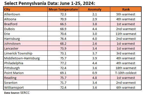
-
Temperatures soared into the upper 80s and even the 90s today. High temperatures included: Bridgeport: 90° Islip: 90° New York City-Central Park: 90° New York City-JFK Airport: 91° New York City-LaGuardia Airport: 91° Newark: 94° Tomorrow will be very warm and humid. The potential exists for strong or severe thunderstorms to develop during the afternoon as a cold front approaches. Much of the region will see the temperature top out at 90° or above. Following the frontal passage, somewhat cooler air will arrive and remain in place through the weekend. Following New York City's 4th warmest spring and Philadelphia's 6th warmest spring, it is very likely that June 2024 will rank among the 10 warmest Junes on record in both cities. Records go back to 1869 in New York City and 1874 in Philadelphia. The latest summer guidance continues to suggest a warmer to much warmer than normal summer lies ahead. The ENSO Region 1+2 anomaly was -0.9°C and the Region 3.4 anomaly was 0.3°C for the week centered around June 19. For the past six weeks, the ENSO Region 1+2 anomaly has averaged -0.88°C and the ENSO Region 3.4 anomaly has averaged +0.15°C. Neutral ENSO conditions will likely evolve into a La Niña event during the late summer or early fall. The SOI was +10.97 today. The preliminary Arctic Oscillation (AO) was +1.398 yesterday. Based on sensitivity analysis applied to the latest guidance, there is an implied near 100% probability that New York City will have a warmer than normal June (1991-2020 normal). June will likely finish with a mean temperature near 75.6° (3.6° above normal). That would make June 2024 the second warmest June on record.
-
Occasional Thoughts on Climate Change
donsutherland1 replied to donsutherland1's topic in Climate Change
That figure came from a handwritten observation sheet. Interestingly enough, while the June 1851 data from that Washington, DC site at Foggy Bottom has been incorporated into the GHCN database, the 1853 one hasn't been entered. The Foggy Bottom site experiences less of a cooling effect from the Potomac River than does Reagan National Airport. -
Occasional Thoughts on Climate Change
donsutherland1 replied to donsutherland1's topic in Climate Change
Yes. It seems that in the short range, the ECMWF can have some unrealistically high temperatures. The GFS sometimes has unrealistically high temperatures show up in the extended range. -
Today provided a respite from the recent heat and humidity that had gripped the region. Despite plenty of sunshine, temperatures remained in the upper 70s and lower 80s in many parts of the region. A stiff breeze provided refreshment. Tomorrow and Wednesday will be very warm days. Much of the region will see the temperature top out at 90° or above. Somewhat cooler air will arrive afterward and remain in place through the weekend. Following New York City's 4th warmest spring and Philadelphia's 6th warmest spring, it is very likely that June 2024 will rank among the 10 warmest Junes on record in both cities. Records go back to 1869 in New York City and 1874 in Philadelphia. The latest summer guidance continues to suggest a warmer to much warmer than normal summer lies ahead. The ENSO Region 1+2 anomaly was -0.9°C and the Region 3.4 anomaly was 0.3°C for the week centered around June 19. For the past six weeks, the ENSO Region 1+2 anomaly has averaged -0.88°C and the ENSO Region 3.4 anomaly has averaged +0.15°C. Neutral ENSO conditions will likely evolve into a La Niña event during the late summer or early fall. The SOI was -14.97 today. The preliminary Arctic Oscillation (AO) was +1.398 today. Based on sensitivity analysis applied to the latest guidance, there is an implied near 100% probability that New York City will have a warmer than normal June (1991-2020 normal). June will likely finish with a mean temperature near 75.6° (3.6° above normal). That would make June 2024 the second warmest June on record.
-
Occasional Thoughts on Climate Change
donsutherland1 replied to donsutherland1's topic in Climate Change
Reframing the message as a "major" or "severe" June heat event might have been more accurate from a meteorological standpoint than the NY Governor's claim that the heatwave would be "unprecedented." But the emphasis was on protecting health and lives. Even yesterday, parts of the Mid-Atlantic region into the Midwast experienced very high rates of heat-related emergency room visits. So, the heat not only set daily and even monthly records, but was also impactful on human health. A disaster specialist might be in a better position to address whether the tradeoff in somewhat overstating the heat risk paid off in reduced heat-related issues. It should also be noted that some on Social Media actually attempted to dismiss the heat as essentially being ordinary for June. Those claims were far more inaccurate than the Governor's exaggeration. Ordinary heat doesn't set daily, much less monthly or even some all-time records. One should ask oneself: If you were in the news media and were aware that extreme heat had already claimed hundreds of lives in other parts of the world, how would you respond to minimize the threat to human health and lives? Would you be willing to gamble that the heat might be less intense at the risk that if you are incorrect, a much larger share of your audience could wind up exposed to higher-than-expected heat risks?
-
Occasional Thoughts on Climate Change
donsutherland1 replied to donsutherland1's topic in Climate Change
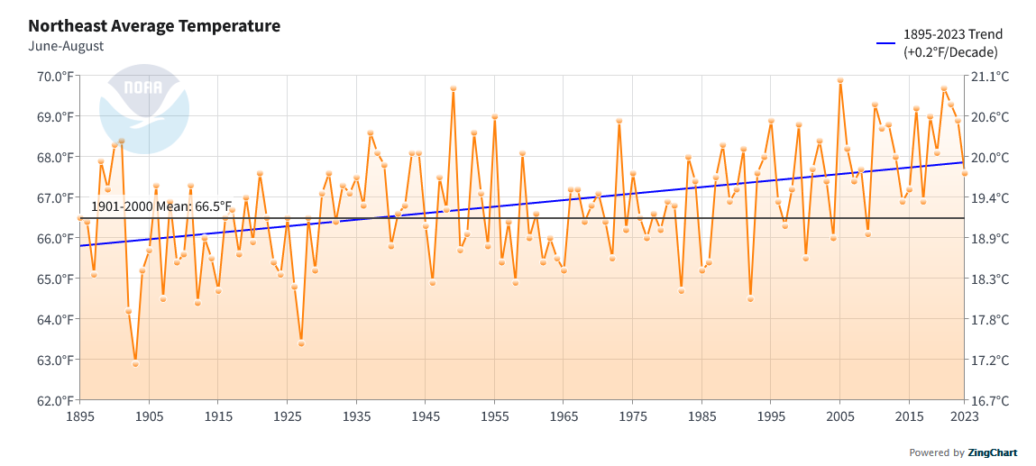
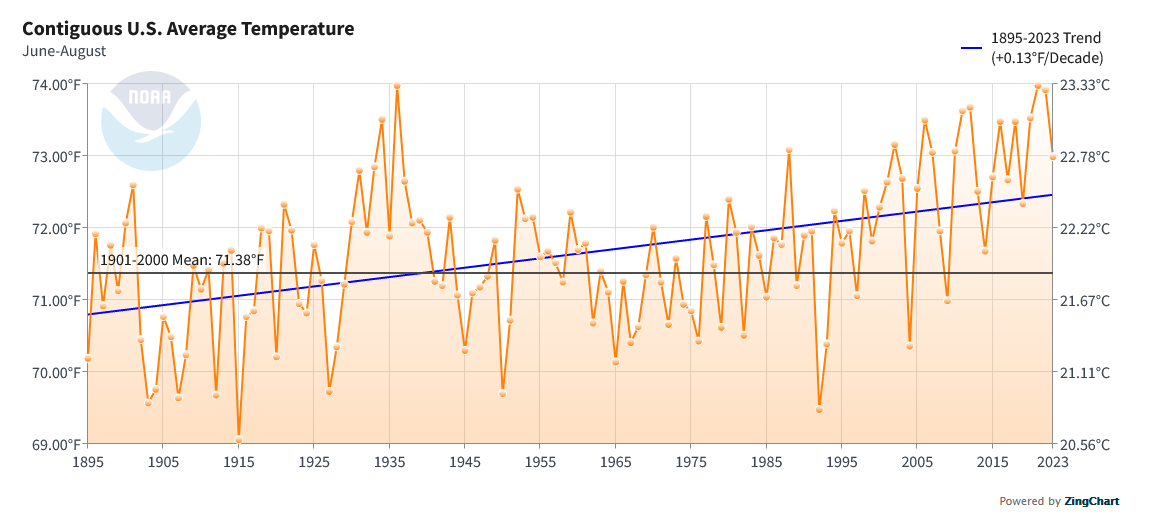
Although the heat was not unprecedented, it was a notable June outbreak. Hundreds of daily high maximum and minimum temperature records were tied or broken. At least 19 monthly high temperature records and 24 monthly high minimum temperature records were tied or broken. Caribou tied its all-time highest temperature. Burlington and Caribou tied their all-time highest minimum temperatures. Fort Kent, where records go back to 1893, demolished its all-time minimum temperature record by 4°. Numerous additional cities came within 1°-2° of their monthly records. Finally, although there are a few regions where there has been no statistical long-range trend (from 1895) for summers, most regions in the U.S. have been experiencing warming summers, as has the contiguous U.S. Northeast: Contiguous United States:

-
Today was another hot day in the Middle Atlantic region. 90° or above high temperatures included: Allentown: 98° (old record: 95°, 1941) Atlantic City: 98° Baltimore: 101° (old record: 100°, 1988) Harrisburg: 99° (old record: 97°, 1988) New York City-Central Park: 93° New York City-LaGuardia Airport: 94° Newark: 95° Philadelphia: 98° Reading: 101° (old record: 96°, 1921) ***highest June temperature since June 26, 1952*** Sterling, VA: 100° (old record: 99°, 1988) Washington, DC: 100° Wilmington, DE: 96° A long stretch of above to much above normal temperatures continues. Tomorrow will be another hot day, but strong to severe thunderstorms could develop. A brief push of cooler air is likely toward the end of the month. More heat could arrive in early July. Baltimore, New York City, Newark, Philadelphia, and Washington, DC are currently experiencing heatwaves. Following New York City's 4th warmest spring and Philadelphia's 6th warmest spring, it is very likely that June 2024 will rank among the 10 warmest Junes on record in both cities. Records go back to 1869 in New York City and 1874 in Philadelphia. The latest summer guidance continues to suggest a warmer to much warmer than normal summer lies ahead. The ENSO Region 1+2 anomaly was -0.6°C and the Region 3.4 anomaly was 0.0°C for the week centered around June 12. For the past six weeks, the ENSO Region 1+2 anomaly has averaged -0.80°C and the ENSO Region 3.4 anomaly has averaged +0.15°C. Neutral ENSO conditions will likely evolve into a La Niña event during the late summer or early fall. The SOI was -9.42 yesterday. The preliminary Arctic Oscillation (AO) was +1.399 today. Based on sensitivity analysis applied to the latest guidance, there is an implied near 100% probability that New York City will have a warmer than normal June (1991-2020 normal). June will likely finish with a mean temperature near 75.7° (3.7° above normal). That would make June 2024 the second warmest June on record.
-
Today was the hottest day so far this summer in parts of the region. High temperatures included: Bridgeport: 91° New York City-Central Park: 94° New York City-JFK Airport: 91° New York City-LaGuardia Airport: 97° Newark: 100° (tied record set in 1953) A long stretch of above to much above normal temperatures is now underway. A brief push of cooler air is likely toward the end of the month. More heat could arrive to start July. Baltimore, Newark, Philadelphia, and Washington, DC are currently experiencing heatwaves. Following New York City's 4th warmest spring and Philadelphia's 6th warmest spring, it is very likely that June 2024 will rank among the 10 warmest Junes on record in both cities. Records go back to 1869 in New York City and 1874 in Philadelphia. The latest summer guidance continues to suggest a warmer to much warmer than normal summer lies ahead. The ENSO Region 1+2 anomaly was -0.6°C and the Region 3.4 anomaly was 0.0°C for the week centered around June 12. For the past six weeks, the ENSO Region 1+2 anomaly has averaged -0.80°C and the ENSO Region 3.4 anomaly has averaged +0.15°C. Neutral ENSO conditions will likely evolve into a La Niña event during the late summer or early fall. The SOI was -13.01 today. The preliminary Arctic Oscillation (AO) was +1.063 today. Based on sensitivity analysis applied to the latest guidance, there is an implied 99% probability that New York City will have a warmer than normal June (1991-2020 normal). June will likely finish with a mean temperature near 75.6° (3.6° above normal). That would make June 2024 the second warmest June on record.
-
Occasional Thoughts on Climate Change
donsutherland1 replied to donsutherland1's topic in Climate Change
It's a fascinating piece. I don't think society is doomed to such an end. At least not yet. Societal simplification or collapse of civilization on a local/regional/global scale is a plausible scenario. Numerous drivers create the risk: climate change where global temperatures rise faster than species/societies can adapt; resource consumption that exceeds global resource production (chronic overshoot) driven by the assumption of perpetual growth unconstrained by sustainability in a finite world; economic systems that are highly efficient within narrow constraints but ill-suited for addressing larger structural issues, etc. There are also important political and geopolitical issues that enhance the impact of the above drivers. Alternative paths also exist. But taking those paths will not be effortless. They will entail challenges that seemingly make the unsustainable status quo approach seem more attractive, as the highest costs of that unsustainable approach still lie in the future. As wonderful as technology is, it may also represent a barrier to departing a familiar, comfortable, but unsustainable status quo. Big things can be done quickly. The Manhattan Plan and Apollo Projects are two examples. The world's coming together to address the threat CFCs posed to the Ozone layer is another. Fossil fuels can be rapidly eliminated. It's a political choice, not a technological one. Defeatist claims that it is impossible have zero merit. Thanks to years and decades of relative inaction, the transition will be bumpier than it would otherwise have been. Additional delay will only make the transition even tougher. That path has largely not been taken, because when it comes to phasing out fossil fuels, the necessary courage, creativity, and leadership have been largely absent. Words set forth at annual COP conferences that are not backed by binding targets and credible enforcement mechanisms ring hollow. COP28 was a failure. The $7 trillion in direct and indirect global subsidies provided to the fossil fuel industry each year feeds the societal addiction and underwrites the industry's ability to distort public policy. Messaging on fossil fuels and climate change is weak and ineffective. Rather than describing heat and heat-related deaths in abstract terms, messaging that would tie the industry to deaths and other harm from the added warming caused by their hazardous products would be better. It would shift the question as to whether the industry should maintain license to take a growing number of lives, just as ultimately became the proposition related to the tobacco industry. The rapid advance of technology has seduced policymakers into an almost blind belief that a technological miracle will rescue them from the consequences of their own inaction. Thus, they cling to that faith and do little. For me, the question is whether there will be a shock of sufficient size that will galvanize humanity to break free from the status quo before an irreversible inflection point is reached at some unknown point in the future. I'm not sure what magnitude is required, but tragically it would likely need to be vastly larger than what the world has already experienced. Otherwise, as has happened in the face of growing heat, drought, and fire disasters, humanity will simply normalize such events and carry on. Should one accept a hopeless fate? No. Humanity still has plenty of agency. So long as humanity can shape the future, catastrophe can be averted. So long as that capacity exists, catastrophe remains a choice, even as some try to assert that choice does not exist. It is a choice, because human society knows what needs to be done and already has the tools to change course. Today, humanity can still avert societal simplification. The effort will be difficult--far more difficult than it would have been decades ago. It should make that effort, if not for the contemporary generation, certainly for future generations who will inherit what is left to them.