batmanbrad
-
Posts
289 -
Joined
-
Last visited
Content Type
Profiles
Blogs
Forums
American Weather
Media Demo
Store
Gallery
Everything posted by batmanbrad
-
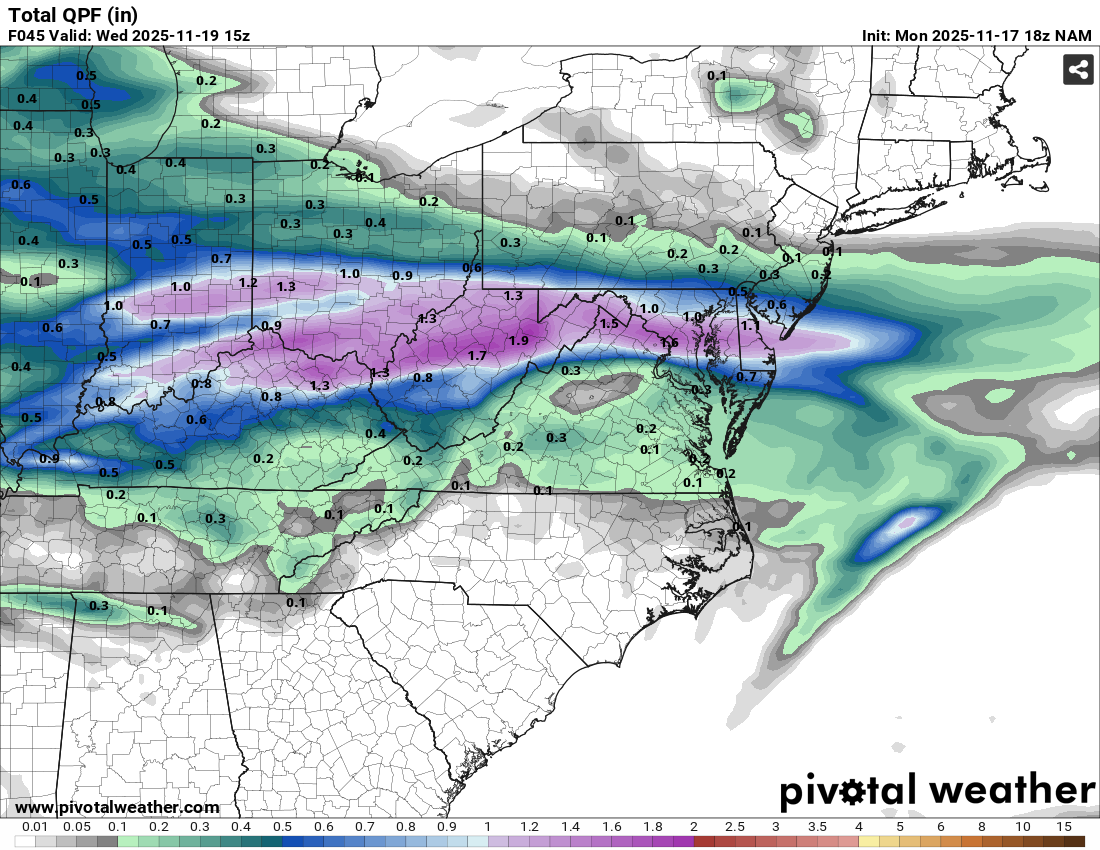
12km NAM doing its NAM thing on us, look at all that 1+" purple!
-
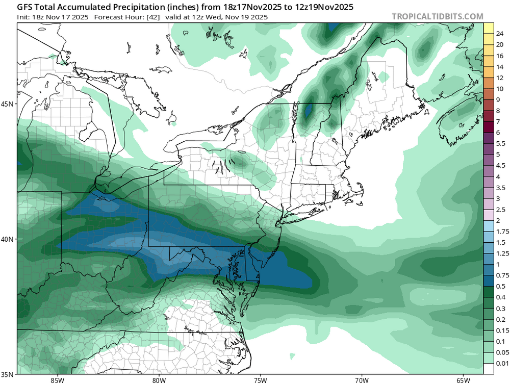
latest 18Z GFS painting over .75" QPF for much of our area, has been trending upward:
-
BWI: 17.8 DCA: 11.4 IAD: 19.5 RIC: 8.5 SBY: 7.5
-
Major Hurricane Melissa - 892mb - 185mph Jamaica landfall
batmanbrad replied to GaWx's topic in Tropical Headquarters
is it stationary because something of an equilibrium has been (temporarily) reached between the competing steering flows? -
Major Hurricane Melissa - 892mb - 185mph Jamaica landfall
batmanbrad replied to GaWx's topic in Tropical Headquarters
both HAFS-A and HAFS-B (12Z) models showing a direct hit to Kingston with around 940mb, yikes -
Major Hurricane Melissa - 892mb - 185mph Jamaica landfall
batmanbrad replied to GaWx's topic in Tropical Headquarters
given that it comes in around Halloween, it would seen that the CMC run is trying to look really... scary. Presumably the 0Z run will be like Monty Python says ("And now for something completely different") -
even more nastiness, yikes: Flash Flood Statement National Weather Service Baltimore MD/Washington DC 540 PM EDT Sat Jul 19 2025 DCC001-MDC031-033-VAC059-200015- /O.CON.KLWX.FF.W.0115.000000T0000Z-250720T0015Z/ /00000.0.ER.000000T0000Z.000000T0000Z.000000T0000Z.OO/ District of Columbia DC-Montgomery MD-Prince Georges MD-Fairfax VA- 540 PM EDT Sat Jul 19 2025 ...FLASH FLOOD WARNING REMAINS IN EFFECT UNTIL 815 PM EDT THIS EVENING FOR THE NORTHWESTERN DISTRICT OF COLUMBIA AND SOUTHEASTERN MONTGOMERY, PRINCE GEORGES AND FAIRFAX COUNTIES... At 540 PM EDT, emergency management reported thunderstorms producing heavy rain in Emergency management reports water rescues in Takoma Park and Silver Spring area. Flood sensors on SLigo Creek at SLigo Creek Parkway and New Hampshire Avenue show a 10 ft rise in 30 mins. . Between 2 and 3.5 inches of rain have fallen. The expected rainfall rate is 1 to 2 inches in 30 minutes. Additional rainfall amounts of 1 to 2 inches are possible in the warned area. Flash flooding is already occurring. HAZARD...Life threatening flash flooding. Thunderstorms producing flash flooding. SOURCE...Emergency management reported. IMPACT...Life threatening flash flooding of creeks and streams, urban areas, highways, streets and underpasses. Some locations that will experience flash flooding include... Bethesda... College Park... Greenbelt... Langley Park... Beltsville... Bladensburg... Fort Totten... American Legion Bridge... University of Maryland... Potomac... North Bethesda... Landover... Hyattsville... Takoma Park... Wolf Trap... East Riverdale... Great Falls... Adelphi... Kemp Mill... New Carrollton...
-
Radarscope has a 2" hail marker on it too edit actually that's the cell SW of Point Of Rocks
-
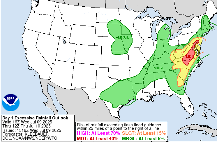
WPC upped parts of our area to MDT risk for flooding per their late morning update...
- 1,378 replies
-
- 1
-

-
- severe
- thunderstorms
- (and 2 more)
-
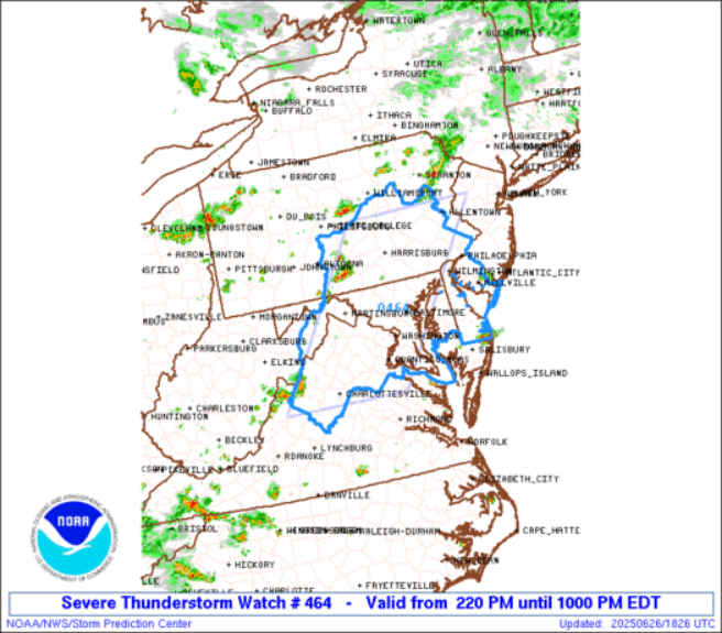
pretty large sized watch area too...
-
and there's our watch as well, just popped up on my phone.
-
DCA: 103 IAD: 101 BWI: 102 RIC: 100
-
at least for now there's what appears to be a decent couplet on that cell north of Winchester... TVS indication per RadarScope
-
not only severe, but WPC says flooding could be a concern too: Mesoscale Precipitation Discussion: #0227 (Issued at 635 PM EDT Mon May 05 2025 ) MPD Selection Mesoscale Precipitation Discussion 0227 NWS Weather Prediction Center College Park MD 635 PM EDT Mon May 05 2025 Areas affected...portions of eastern VA into the DMV and far eastern WV Concerning...Heavy rainfall...Flash flooding possible Valid 052235Z - 060300Z Summary...Training convection will be capable of hourly totals of 1-3" with short-term (3-hr) totals as high as 2-4". Isolated to scattered instances of flash flooding are possible (and may be locally significant in sensitive urban/mountainous terrain). Discussion...Radar and GOES-East satellite imagery indicate the proliferation of convection across portions of eastern VA/NC over the past several hours, moving fairly rapidly (~25 kts) towards the N-NE within nearly unidirectional flow on the eastern periphery of a large, deep layer (850-200 mb) closed low centered over IL/IN/KY. The mesoscale environment in the vicinity and downstream of the aforementioned convection is characterized by SBCAPE of 1000-2000 J/kg, PWATs of 0.8-1.3" (between the 75th and 90th percentile, per IAD sounding climatology), and deep layer (0-6km shear) of 20-40 kts (per 22z SPC SFCOA analysis). The strongest cells have been capable of impressive instantaneous rainfall rates of 3-5"/hr (per MRMS estimates), which has resulted in estimated hourly rainfall totals of up to 2.5" (where deeper convective cells have been able to occasionally train, mainly to the east of I-95 in eastern VA). Recent hi-res CAMs have not handled the evolution of convection particularly well, and recent observational trends (including continued overshooting/cooling cloud tops via GOES-East imagery) suggest that localized hourly totals of 1-3" will continue to manifest farther north (into the more sensitive DMV region) with storm propagation (as a pool of 1500-2000 J/kg of SBCAPE remains untapped). While both of the hourly updating CAMs (HRRR/RRFS) are handling the convection poorly, the 18z HREF suite does still give a good idea of the potential for excessive rainfall through 03z (with 40-km neighborhood probabilities for 2" and 3" exceedance of 20-30% and ~10%, respectively). Given locally sensitive terrain (per FFGs as low as 0.75-1.50" and 1.50-2.50" for 1-hr and 3-hr periods, respectively) over urbanized terrain along and near I-95 and over portions of the Appalachians in the vicinity of northern VA, western MD, and far eastern WV, isolated to scattered instances of flash flooding are possible (and may be locally significant, should 2-4" totals occur over the most sensitive localities). Churchill ATTN...WFO...AKQ...CTP...LWX...RAH... ATTN...RFC...MARFC...SERFC...NWC... LAT...LON 39827743 39597667 39037647 37767669 36447699 36217739 36777738 37437742 38277778 39617833
- 1,378 replies
-
- 4
-
-
- severe
- thunderstorms
- (and 2 more)
-
might have been a "false alarm", but I was getting a TVS on the cell NW of Leesburg on RadarScope for a bit, but it seems to have disappeared.
-
I'm sure DT loves this run, both for it being a jack in his area and because he worships the Euro.
-
1/19 - The Roulette Wheel 29 Black Storm - OBS
batmanbrad replied to DDweatherman's topic in Mid Atlantic
looks like a modest band about to cross I-270 in Moco... and perhaps one more moving east of Winchester, that's about it. -
don't forget... Georgetown 0" snow, all rain
-
January Medium/Long Range: A snowy January ahead?
batmanbrad replied to mappy's topic in Mid Atlantic
now ya got me humming "Kind Of A Drag" by the Buckinghams.... LOL. I'm originally from NJ (not as far northwest as Walt is right now) but I skiied a lot in Vermont and New Hampshire and would always read Walt's discussions with mucho interest and enthusiasm especially during winters. -
January Medium/Long Range: A snowy January ahead?
batmanbrad replied to mappy's topic in Mid Atlantic
I bet nobody would have thought the (healthy) storm we are getting tomorrow would potentially serve as an "appetizer" for what the GFS is advertising for next weekend! -
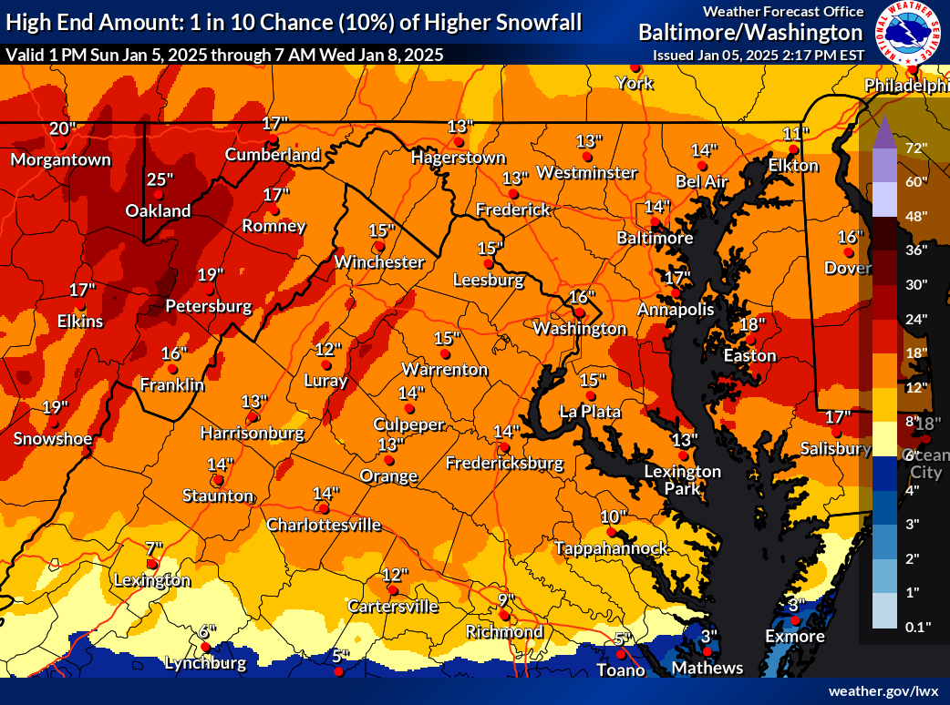
and for all the optimists, here's the corresponding 10% chance map, also has been increased!

-
January: Medium/ Long Range: May the Force be with Us....
batmanbrad replied to Weather Will's topic in Mid Atlantic
along with countless references to the infamous DC Snowhole -
nice fatties near the end of this band coming through Gaithersburg (near Laytonsville)
-
some may have thought this was an underperformer but at the MoCo Airpark they've measured about an inch as of the 2PM obs, and certainly we could squeeze out another 1/4 to 1/2 inch here... since they'd basically been predicting 1-2" areawide today, that seems pretty much on target.
-
radar seems to be showing another line about to (slowly) enter western MoCo soon - maybe not (yet?) quite as potent as the last line that went through recently, but we'll see. Could even have a bit of a training effect as the heavier precip is sliding SW to NE as the line itself gradually pushes east.