batmanbrad
-
Posts
304 -
Joined
-
Last visited
Content Type
Profiles
Blogs
Forums
American Weather
Media Demo
Store
Gallery
Everything posted by batmanbrad
-
2026 Mid-Atlantic Severe Storm General Discussion
batmanbrad replied to Kmlwx's topic in Mid Atlantic
at least 15 minutes of VERY heavy rain here in Gaithersburg (NE side, near Laytonsville). Not much thunder/lightning, but stuck under good radar returns - not exactly training, but in no big hurry to move outta here either. -
2026 Mid-Atlantic Severe Storm General Discussion
batmanbrad replied to Kmlwx's topic in Mid Atlantic
we just got one, so good guess! -
2026 Mid-Atlantic Severe Storm General Discussion
batmanbrad replied to Kmlwx's topic in Mid Atlantic
and in the 1:30PM update the ENH was expanded eastward, now covers all or nearly all of our area. -
2026 Mid-Atlantic Severe Storm General Discussion
batmanbrad replied to Kmlwx's topic in Mid Atlantic
the stuff S/SW of Leesburg between Middleburg and Arcola looking quite healthy -
2026 Mid-Atlantic Severe Storm General Discussion
batmanbrad replied to Kmlwx's topic in Mid Atlantic
Yep just got warned - if it holds together could affect DC given its NE motion... -
2026 Mid-Atlantic Severe Storm General Discussion
batmanbrad replied to Kmlwx's topic in Mid Atlantic
looks like that storm had been moving E or even ENE, but when it ramped up and got tornado warned, it made a right turn and is now headed SE, probably towards the Damascus area. -
2026 Mid-Atlantic Severe Storm General Discussion
batmanbrad replied to Kmlwx's topic in Mid Atlantic
visible does seem to show some decent clearing as you get west of MoCo...
- 1,468 replies
-
- 2
-

-
- severe
- thunderstorms
- (and 7 more)
-
Big Heat (and storms?) Week into July 4th Weekend
batmanbrad replied to yoda's topic in Mid Atlantic
it's got some hail potential according to RadarScope, and it isn't moving very fast either so training and potential flood issues are there if the cell maintains itself. -
2026 Mid-Atlantic Severe Storm General Discussion
batmanbrad replied to Kmlwx's topic in Mid Atlantic
recent discussion from WPC highlights flood potential: Excessive Rainfall Discussion NWS Weather Prediction Center College Park MD 1149 AM EDT Sat Jul 4 2026 Day 2 Valid 12Z Sun Jul 05 2026 - 12Z Mon Jul 06 2026 ...THERE IS A SLIGHT RISK OF EXCESSIVE RAINFALL ACROSS PORTIONS OF THE MID-ATLANTIC... An east-west orientated front boundary will be sprawled across the Northeast/northern Mid-Atlantic region during this period. Moderate instability combined with PW values of 2+ inches are expected to overlap near the frontal boundary to produce periods of heavy rainfall. This area historically is more prone to flash flooding due to terrain influences and more sensitive hydrologic schemes thus maintaining the Slight Risk for excessive rainfall for this part of the region. Backbuilding and training of thunderstorms may be possible. Scattered flash flood concerns exist over the central Mid- Atlantic with an increasing risk of heavy convection over portions of Pennsylvania down through the Washington DC- Baltimore- Philadelphia corridor. A broad Marginal Risk area spans from eastern Oklahoma/Kansas eastward to the Mid- Atlantic/southern portions of the Northeast. -
2026 Mid-Atlantic Severe Storm General Discussion
batmanbrad replied to Kmlwx's topic in Mid Atlantic
looks like few if any changes on the 13z SPC outlook -
2026 Mid-Atlantic Severe Storm General Discussion
batmanbrad replied to Kmlwx's topic in Mid Atlantic
whoa that cell near Manassas sure got itself together in a hurry... could be heading for DC? -
2026 Mid-Atlantic Severe Storm General Discussion
batmanbrad replied to Kmlwx's topic in Mid Atlantic
WPC just issued an MPD for our area - warns of heavy rain leading to possible flash flooding: https://www.wpc.ncep.noaa.gov/metwatch/metwatch_mpd_multi.php?md=0499&yr=2026- 1,468 replies
-
- 1
-
-
- severe
- thunderstorms
- (and 7 more)
-
2026 Mid-Atlantic Severe Storm General Discussion
batmanbrad replied to Kmlwx's topic in Mid Atlantic
for those hoping for at least drought-denting rainfall, WPC shares some decent possibilities in their latest ERO/ERD: ...Central Appalachians to Northeast U.S... Surface low currently analyzed over the western Ohio Valley will gradually lift to the east-northeast with an expectation for the low center to exit off the northern Mid Atlantic coast, dragging a cold front through the Mid Atlantic and Ohio Valley and lifting a warm front ahead of the disturbance. The current indications are for convection to spawn over the eastern Ohio Valley by the early- afternoon as mid-level ascent and increased surface forcing aided by the cold front and area of low pressure will trigger convective initiation just upstream of the terrain in WV and western PA. This area of thunderstorms will migrate eastward, entering a favorable environment within a modest warm sector as you move east of the Appalachian front. Shear profiles across the Mid Atlantic are anticipated to be greatest north of the Mason Dixon, however shear magnitudes are still capable for enabling stronger mid-level mesocyclones to materialize and hold as far south as I-66 leading to prospects for heavier thunderstorms to hold across the urban corridor extending from northern VA up through NYC and western LI. HREF probs for >1" are pretty high for both the neighborhood and EAS fields meaning there's a consensus for areas of heavy rainfall to impact much of the Mid Atlantic with the most pronounced signatures into the Central Appalachians and the urban centers, both are which are susceptible to flash flood concerns. Antecedent soil moisture is dry, so the initial burst of rainfall will be beneficial to those areas not tied completely by urban infrastructure, however, there's a sufficient signal in the QPF means to maintain the previous SLGT risk inherited for the region as 00z CAMs maintained their depictions on a multi-round cycle of convection moving into the area with pockets of 2-3+" forecast across portions of the aforementioned areas. -
2026 Mid-Atlantic Severe Storm General Discussion
batmanbrad replied to Kmlwx's topic in Mid Atlantic
does look clear esp. over MoCo as of now, though there are some clouds to the west so unless those dissipate as they move out of the mountains, we'll probably have intervals of both clear skies and some cloud cover: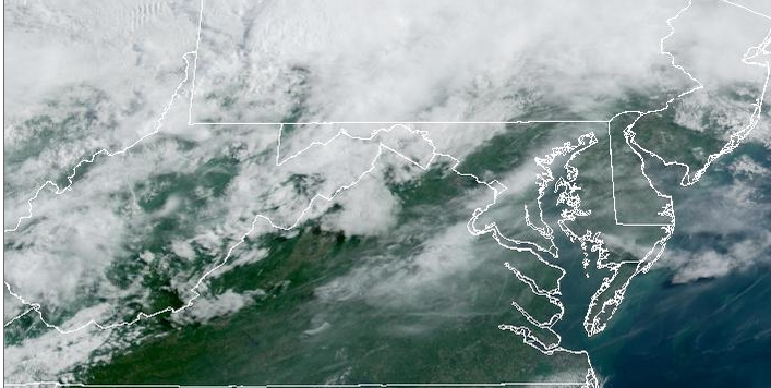
- 1,468 replies
-
- 2
-
-
- severe
- thunderstorms
- (and 7 more)
-
2026 Mid-Atlantic Severe Storm General Discussion
batmanbrad replied to Kmlwx's topic in Mid Atlantic
not much change in the newest SPC day 2 outlook for our area, they held the TOR prob at 2% and mentioned too much uncertainty about degree of destabilization to warrant upgrading to 5% -
2026 Mid-Atlantic Severe Storm General Discussion
batmanbrad replied to Kmlwx's topic in Mid Atlantic
noting we've been put in a SLGT for Sunday as well by SPC -
2026 Mid-Atlantic Severe Storm General Discussion
batmanbrad replied to Kmlwx's topic in Mid Atlantic
SPC did keep the 30 wind area in their 9AM update, but did shift it a bit E/SE, otherwise few changes - as you say, we'll see if anything improves on the CAMs otherwise many of us may (again) be disappointed. -
2026 Mid-Atlantic Severe Storm General Discussion
batmanbrad replied to Kmlwx's topic in Mid Atlantic
I can see some gust front/outflow boundaries pushing out ahead of that line -
2026 Mid-Atlantic Severe Storm General Discussion
batmanbrad replied to Kmlwx's topic in Mid Atlantic
so far the line of storms coming out of WV and western MD seems to be holding together pretty well - wondering what it will do when it comes over the mountains and hits the pea soup air over us right now. If it keeps moving quickly it'll hit before we completely lose sunlight... -
currently right underneath that cell moving through the Germantown/Gaithersburg/Laytonsville area, not much T&L but big time downpour going on for the last 10-15 minutes (and counting), with more behind it this might be flash flood territory if it doesn't move out soon?
-
current radar trends are supporting the earlier thinking that most of the major activity will be north of DC...
-
2026 Mid-Atlantic Severe Storm General Discussion
batmanbrad replied to Kmlwx's topic in Mid Atlantic
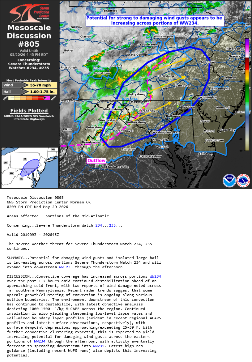
SPC issued another MD for our area, seems to indicate things are continuing to ramp up somewhat: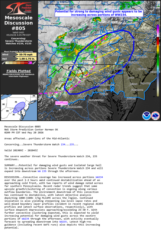
- 1,468 replies
-
- 2
-
-
- severe
- thunderstorms
- (and 7 more)
-
Radarscope showing some increase in hail size, POSH's up to 40-50% on some of those cells out west including the one you mention.
-
2026 Mid-Atlantic Severe Storm General Discussion
batmanbrad replied to Kmlwx's topic in Mid Atlantic
alerted on Radarscope of an MCD issued for our area, 80% chance of a blue box coming. -
2026 Mid-Atlantic Severe Storm General Discussion
batmanbrad replied to Kmlwx's topic in Mid Atlantic
The latest forecast for me (Gaithersburg) STILL has no mention of severe for tomorrow, doesn't mention thunder at all! I checked the point-and-clicks for several other cities/counties in our area... nada.